AL, 90, 2020112800, , BEST, 0, 455N, 181W, 30, 1000, EX
ATL: INVEST 90L - Discussion
Moderator: S2k Moderators
-
Nancy Smar

- Category 5

- Posts: 1081
- Age: 25
- Joined: Wed Aug 16, 2017 10:03 pm
ATL: INVEST 90L - Discussion
Last edited by Nancy Smar on Sat Nov 28, 2020 12:15 am, edited 2 times in total.
0 likes

Re: ATL: INVEST 90L - Discussion
Seasons often produce "interesting" systems like these, which don't develop, as a last sign of life before finally pettering out for the off season.
0 likes
All posts by Dean_175 are NOT official forecasts and should not be used as such. They are just the opinion of the poster and may or may not be backed by sound meteorological data. They are NOT endorsed by any professional institution or storm2k.org. For official information, please refer to the NHC and NWS products.

Re: ATL: INVEST 90L - Discussion
The HWRF has this become a hurricane by Day 4. Hurricane Kappa in early December...only in 2020 lol.
2 likes
Irene '11 Sandy '12 Hermine '16 5/15/2018 Derecho Fay '20 Isaias '20 Elsa '21 Henri '21 Ida '21
I am only a meteorology enthusiast who knows a decent amount about tropical cyclones. Look to the professional mets, the NHC, or your local weather office for the best information.
I am only a meteorology enthusiast who knows a decent amount about tropical cyclones. Look to the professional mets, the NHC, or your local weather office for the best information.
-
Sciencerocks
- Category 5
- Posts: 10186
- Age: 40
- Joined: Thu Jul 06, 2017 1:51 am
Re: ATL: INVEST 90L - Discussion
A non-tropical low pressure system over the far eastern Atlantic is
expected to move southward about midway between Portugal and the
Azores over the weekend. Environmental conditions are forecast to be
marginally conducive for the low to acquire subtropical
characteristics early next week while it meanders just to the north
of the Canary Islands. Additional information on this system can be
found in high seas forecasts issued by Meteo France.
* Formation chance through 48 hours...low...10 percent.
* Formation chance through 5 days...low...30 percent.
0 likes
-
cycloneye

- Admin

- Posts: 149503
- Age: 69
- Joined: Thu Oct 10, 2002 10:54 am
- Location: San Juan, Puerto Rico
Re: ATL: INVEST 90L - Discussion
2 PM.
A strong, non-tropical low pressure system over the far eastern
Atlantic is expected to move southward about midway between Portugal
and the Azores through the weekend. Environmental conditions could
allow the low to acquire subtropical characteristics early next week
while it meanders just to the north of the Canary Islands. By the
middle of next week, environmental conditions are forecast to become
unfavorable for further development. Additional information on this
system can be found in high seas forecasts issued by Meteo France.
* Formation chance through 48 hours...low...20 percent.
* Formation chance through 5 days...low...30 percent.
0 likes
Visit the Caribbean-Central America Weather Thread where you can find at first post web cams,radars
and observations from Caribbean basin members Click Here
and observations from Caribbean basin members Click Here
-
CrazyC83
- Professional-Met

- Posts: 34315
- Joined: Tue Mar 07, 2006 11:57 pm
- Location: Deep South, for the first time!
Re: ATL: INVEST 90L - Discussion
It would be a much more fitting end to the season than the last storm becoming a category 5 monster though. At least this is in a more traditional position for a late-season last hurrah.
1 likes
-
ElectricStorm

- Category 5
- Posts: 5147
- Age: 25
- Joined: Tue Aug 13, 2019 11:23 pm
- Location: Norman, OK
Re: ATL: INVEST 90L - Discussion
I have a feeling this will be the last real chance of development this season. Although the way this year has gone, I wouldn't be surprised if we get another one in December.
0 likes
B.S Meteorology, University of Oklahoma '25
Please refer to the NHC, NWS, or SPC for official information.
Please refer to the NHC, NWS, or SPC for official information.
-
CrazyC83
- Professional-Met
- Posts: 34315
- Joined: Tue Mar 07, 2006 11:57 pm
- Location: Deep South, for the first time!
Re: ATL: INVEST 90L - Discussion
Weather Dude wrote:I have a feeling this will be the last real chance of development this season. Although the way this year has gone, I wouldn't be surprised if we get another one in December.
Some models show a SW Caribbean system next week.
1 likes
-
supercane4867
- Category 5
- Posts: 4966
- Joined: Wed Nov 14, 2012 10:43 am
Re: ATL: INVEST 90L - Discussion
Models seem to be very optimistic on the development of a subtropical storm. I think the chance we get Kappa out of this is high.
1 likes
-
AJC3

- Admin
- Posts: 4156
- Age: 62
- Joined: Tue Aug 31, 2004 7:04 pm
- Location: Ballston Spa, New York
- Contact:
Re: ATL: INVEST 90L - Discussion
A strong and large non-tropical low pressure system over the far
eastern Atlantic is expected to continue moving southward during the
next day or so. This low could acquire subtropical characteristics
in a couple of days while it meanders just to the north of the
Canary Islands. By the middle of the week, environmental conditions
are forecast to become unfavorable for further development.
Additional information on this system can be found in High Seas
Forecasts issued by Meteo France.
* Formation chance through 48 hours...low...20 percent.
* Formation chance through 5 days...low...30 percent.
0 likes
-
cycloneye
- Admin
- Posts: 149503
- Age: 69
- Joined: Thu Oct 10, 2002 10:54 am
- Location: San Juan, Puerto Rico
Re: ATL: INVEST 90L - Discussion
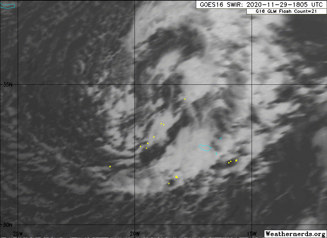
Tropical Weather Outlook
NWS National Hurricane Center Miami FL
700 AM EST Sun Nov 29 2020
For the North Atlantic...Caribbean Sea and the Gulf of Mexico:
A strong and large non-tropical low pressure system over the far
eastern Atlantic is expected to continue moving southward during the
next day or so. The associated shower and thunderstorm activity has
become a little better organized this morning, and the low could
acquire subtropical characteristics in a couple of days while it
meanders just to the north of the Canary Islands. By the middle of
the week, environmental conditions are forecast to become
unfavorable for further development. Regardless of development,
this system could cause strong winds and locally heavy rains in the
Madeira Islands later today through Monday. Additional information
on this system can be found in High Seas Forecasts issued by Meteo
France.
* Formation chance through 48 hours...low...30 percent.
* Formation chance through 5 days...medium...40 percent.
&&
High Seas Forecasts issued by Meteo France can be found under WMO
header FQNT50 LFPW.
$$
Forecaster Beven
0 likes
Visit the Caribbean-Central America Weather Thread where you can find at first post web cams,radars
and observations from Caribbean basin members Click Here
and observations from Caribbean basin members Click Here

-
Sciencerocks
- Category 5
- Posts: 10186
- Age: 40
- Joined: Thu Jul 06, 2017 1:51 am
Re: ATL: INVEST 90L - Discussion
Tropical Weather Outlook
NWS National Hurricane Center Miami FL
100 PM EST Sun Nov 29 2020
Shower and thunderstorm activity associated with a strong and large
non-tropical low pressure system over the far eastern Atlantic has
become a little better organized since yesterday. This low could
acquire subtropical characteristics during the next couple of days
while it meanders just to the north of the Canary Islands. By the
middle of the week, environmental conditions are forecast to become
unfavorable for further development. Regardless of development, this
system should cause strong winds and locally heavy rains in the
Madeira Islands through Monday or Tuesday. Additional information
on this system can be found in High Seas Forecasts issued by Meteo
France.
* Formation chance through 48 hours...medium...40 percent.
* Formation chance through 5 days...medium...40 percent.
0 likes
-
Sciencerocks
- Category 5
- Posts: 10186
- Age: 40
- Joined: Thu Jul 06, 2017 1:51 am
Re: ATL: INVEST 90L - Discussion
This is starting to look less likely to develop. No model, not even the HWRF, shows this concentrating into a tropical or subtropical system, and now there’s a time limit before it gets ripped to shreds. 90L might end up as yet another failed AOI.
0 likes
Irene '11 Sandy '12 Hermine '16 5/15/2018 Derecho Fay '20 Isaias '20 Elsa '21 Henri '21 Ida '21
I am only a meteorology enthusiast who knows a decent amount about tropical cyclones. Look to the professional mets, the NHC, or your local weather office for the best information.
I am only a meteorology enthusiast who knows a decent amount about tropical cyclones. Look to the professional mets, the NHC, or your local weather office for the best information.
-
HurricaneEnzo

- Category 2

- Posts: 744
- Joined: Wed Mar 14, 2018 12:18 pm
- Location: Newport, NC (Hurricane Alley)
Re: ATL: INVEST 90L - Discussion
Doesn't look like it has any tropical characteristics but it sure is a big impressive area of low pressure!
https://www.tropicaltidbits.com/sat/sat ... product=ir
https://www.tropicaltidbits.com/sat/sat ... product=ir
0 likes
Bertha 96' - Fran 96' - Bonnie 98' - Dennis 99' - Floyd 99' - Isabel 03' - Alex 04' - Ophelia 05' - Irene 11' - Arthur 14' - Matthew 16' - Florence 18' - Dorian 19' - Isaias 20' (countless other tropical storms and Hurricane swipes)
I am not a Professional Met just an enthusiast. Get your weather forecasts from the Pros!
I am not a Professional Met just an enthusiast. Get your weather forecasts from the Pros!
-
CrazyC83
- Professional-Met
- Posts: 34315
- Joined: Tue Mar 07, 2006 11:57 pm
- Location: Deep South, for the first time!
Re: ATL: INVEST 90L - Discussion
The low is well defined and clear. Just need central convection closer to the low center.
0 likes
-
CrazyC83
- Professional-Met
- Posts: 34315
- Joined: Tue Mar 07, 2006 11:57 pm
- Location: Deep South, for the first time!
Re: ATL: INVEST 90L - Discussion
The OPC analysis shows a clearly non-frontal low. It seems the lack of convection is the limiting factor - how much more is needed for an STC?
1 likes
-
Hurricanehink

- S2K Supporter

- Posts: 2045
- Joined: Sun Nov 16, 2003 2:05 pm
- Location: New Jersey
Re: ATL: INVEST 90L - Discussion
http://moe.met.fsu.edu/cyclonephase/ - it's still slightly cold core, or neutral, according to its phase diagram. The models have it transitioning overnight though.
1 likes
-
CrazyC83
- Professional-Met
- Posts: 34315
- Joined: Tue Mar 07, 2006 11:57 pm
- Location: Deep South, for the first time!
Re: ATL: INVEST 90L - Discussion
Convection has increased somewhat this evening. It isn't there yet though but might have a shot.
0 likes
Who is online
Users browsing this forum: No registered users and 58 guests