The unnamed Tropical Storm that was upgraded from TD-7-E is up.
Will the same happen to TD 10?
2020 TCRs
Moderator: S2k Moderators
Forum rules

The posts in this forum are NOT official forecasts and should not be used as such. They are just the opinion of the poster and may or may not be backed by sound meteorological data. They are NOT endorsed by any professional institution or STORM2K. For official information, please refer to products from the National Hurricane Center and National Weather Service.
-
cycloneye

- Admin

- Posts: 149712
- Age: 69
- Joined: Thu Oct 10, 2002 10:54 am
- Location: San Juan, Puerto Rico
Re: 2020 TCRs
3 likes
Visit the Caribbean-Central America Weather Thread where you can find at first post web cams,radars
and observations from Caribbean basin members Click Here
and observations from Caribbean basin members Click Here
-
galaxy401

- Category 5

- Posts: 2446
- Age: 30
- Joined: Sat Aug 25, 2012 9:04 pm
- Location: Casa Grande, Arizona
Re: 2020 TCRs
A little surprise to wake up to this morning. First TD in quite a while to be upgraded to a TS post-season I believe.
0 likes
Got my eyes on moving right into Hurricane Alley: Florida.
-
ElectricStorm

- Category 5
- Posts: 5155
- Age: 25
- Joined: Tue Aug 13, 2019 11:23 pm
- Location: Norman, OK
Re: 2020 TCRs
cycloneye wrote:The unnamed Tropical Storm that was upgraded from TD-7-E is up.
Will the same happen to TD 10?
Interesting. I think TD 6-E has a chance to be upgraded also
1 likes
B.S Meteorology, University of Oklahoma '25
Please refer to the NHC, NWS, or SPC for official information.
Please refer to the NHC, NWS, or SPC for official information.

Re: 2020 TCRs
cycloneye wrote:The unnamed Tropical Storm that was upgraded from TD-7-E is up.
Will the same happen to TD 10?
One of the random EPac slop TDs getting upgraded was the last thing I expected. I guess TD10’s chances of getting a post-season TS upgrade just rose.
2 likes
Irene '11 Sandy '12 Hermine '16 5/15/2018 Derecho Fay '20 Isaias '20 Elsa '21 Henri '21 Ida '21
I am only a meteorology enthusiast who knows a decent amount about tropical cyclones. Look to the professional mets, the NHC, or your local weather office for the best information.
I am only a meteorology enthusiast who knows a decent amount about tropical cyclones. Look to the professional mets, the NHC, or your local weather office for the best information.
-
CrazyC83
- Professional-Met

- Posts: 34316
- Joined: Tue Mar 07, 2006 11:57 pm
- Location: Deep South, for the first time!
Re: 2020 TCRs
Quite surprising - also they called it Unnamed TS and not TS 7-E, so if TD 10 is upgraded, that would be the classification?
I do wonder if the system in the central Atlantic in late November could be reclassified? There was a point for at least about 12-24 hours that it looked like a subtropical cyclone.
I do wonder if the system in the central Atlantic in late November could be reclassified? There was a point for at least about 12-24 hours that it looked like a subtropical cyclone.
1 likes
-
Sciencerocks
- Category 5
- Posts: 10193
- Age: 40
- Joined: Thu Jul 06, 2017 1:51 am
Re: 2020 TCRs
aspen wrote:cycloneye wrote:The unnamed Tropical Storm that was upgraded from TD-7-E is up.
Will the same happen to TD 10?
One of the random EPac slop TDs getting upgraded was the last thing I expected. I guess TD10’s chances of getting a post-season TS upgrade just rose.
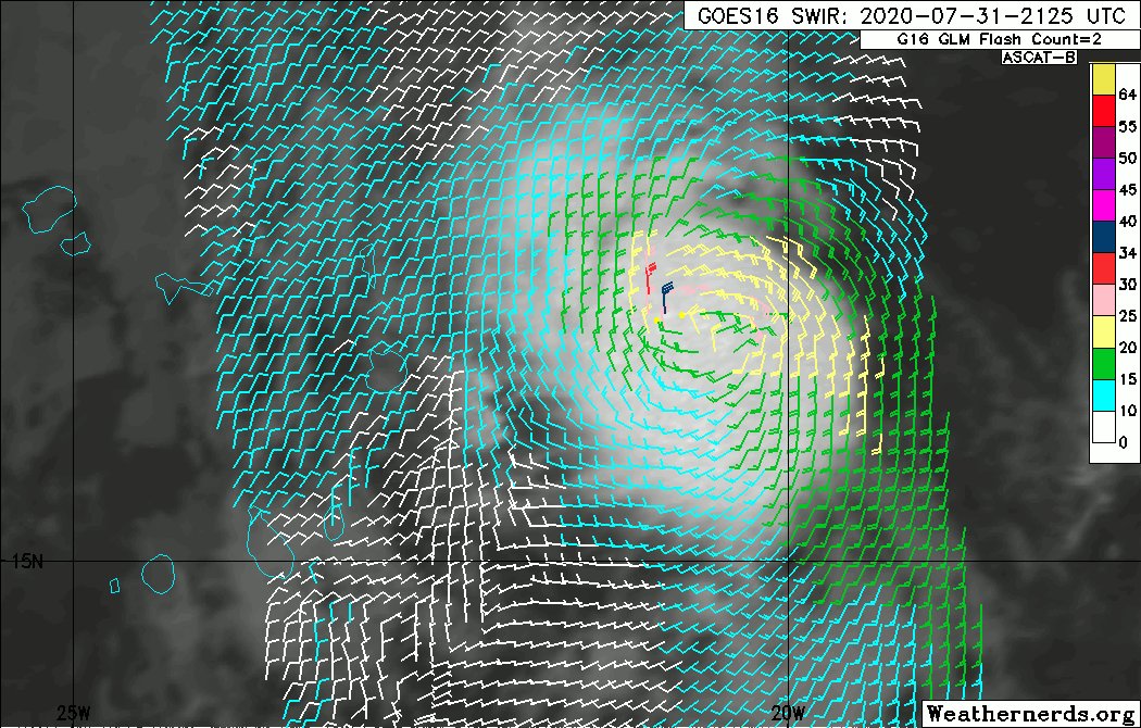
I believe td 10 had ascat showing 35 knot winds and I was floored when it wasn't upgraded. It looked far better then td 7e ever did.
Philippe Papin
@pppapin
We got yet another #ASCAT hit on #TD10 which is just east of the Cape Verde islands. Despite the small size of the vortex, ASCAT found a single >34kt wind barb. A likely upgrade to tropical storm for the 11pm EDT advisory... to cap off a record breaking July for the NATL basin.
1 likes
-
MarioProtVI
- Category 5
- Posts: 1039
- Age: 24
- Joined: Sun Sep 29, 2019 7:33 pm
- Location: New Jersey
Re: 2020 TCRs
Sciencerocks wrote:aspen wrote:cycloneye wrote:The unnamed Tropical Storm that was upgraded from TD-7-E is up.
Will the same happen to TD 10?
One of the random EPac slop TDs getting upgraded was the last thing I expected. I guess TD10’s chances of getting a post-season TS upgrade just rose.
I believe td 10 had ascat showing 35 knot winds and I was floored when it wasn't upgraded. It looked far better then td 7e ever did.
Philippe Papin
@pppapin
We got yet another #ASCAT hit on #TD10 which is just east of the Cape Verde islands. Despite the small size of the vortex, ASCAT found a single >34kt wind barb. A likely upgrade to tropical storm for the 11pm EDT advisory... to cap off a record breaking July for the NATL basin.
https://pbs.twimg.com/tweet_video_thumb/EeS8VgIXYAE8SFK.jpg
I’m not sold on a likely upgrade for 10L...iirc the convection started degrading shortly afterwards and the barb could have been contaminated.
0 likes
-
ElectricStorm
- Category 5
- Posts: 5155
- Age: 25
- Joined: Tue Aug 13, 2019 11:23 pm
- Location: Norman, OK
Re: 2020 TCRs
MarioProtVI wrote:Sciencerocks wrote:aspen wrote:One of the random EPac slop TDs getting upgraded was the last thing I expected. I guess TD10’s chances of getting a post-season TS upgrade just rose.
I believe td 10 had ascat showing 35 knot winds and I was floored when it wasn't upgraded. It looked far better then td 7e ever did.
Philippe Papin
@pppapin
We got yet another #ASCAT hit on #TD10 which is just east of the Cape Verde islands. Despite the small size of the vortex, ASCAT found a single >34kt wind barb. A likely upgrade to tropical storm for the 11pm EDT advisory... to cap off a record breaking July for the NATL basin.
https://pbs.twimg.com/tweet_video_thumb/EeS8VgIXYAE8SFK.jpg
I’m not sold on a likely upgrade for 10L...iirc the convection started degrading shortly afterwards and the barb could have been contaminated.
I'm with you. I feel like if they're going to use that ASCAT pass to upgrade, they would have done it operationally
0 likes
B.S Meteorology, University of Oklahoma '25
Please refer to the NHC, NWS, or SPC for official information.
Please refer to the NHC, NWS, or SPC for official information.

Re: 2020 TCRs
Weather Dude wrote:MarioProtVI wrote:Sciencerocks wrote:
I believe td 10 had ascat showing 35 knot winds and I was floored when it wasn't upgraded. It looked far better then td 7e ever did.
Philippe Papin
@pppapin
We got yet another #ASCAT hit on #TD10 which is just east of the Cape Verde islands. Despite the small size of the vortex, ASCAT found a single >34kt wind barb. A likely upgrade to tropical storm for the 11pm EDT advisory... to cap off a record breaking July for the NATL basin.
https://pbs.twimg.com/tweet_video_thumb/EeS8VgIXYAE8SFK.jpg
I’m not sold on a likely upgrade for 10L...iirc the convection started degrading shortly afterwards and the barb could have been contaminated.
I'm with you. I feel like if they're going to use that ASCAT pass to upgrade, they would have done it operationally
But the ASCAT passes aren’t always timed so well in-between advisory cycles. This system was so small that it fluctuated quickly.
I think it is very likely NHC will upgrade TD10 since the last advisory mentioned that earlier it appeared to “possibly” be a TS, but you gotta read in-between the lines there. I just think it was so short lived in-between advisory cycles that giving it a name operationally was pointless.
If it gets the upgrade, its TS timeline i’d imagine will be very short, possibly on a few hours or so but the NHC will probably mention that ASCAT pass in the report.
1 likes
-
ElectricStorm
- Category 5
- Posts: 5155
- Age: 25
- Joined: Tue Aug 13, 2019 11:23 pm
- Location: Norman, OK
Re: 2020 TCRs
ClarCari wrote:Weather Dude wrote:MarioProtVI wrote:
I’m not sold on a likely upgrade for 10L...iirc the convection started degrading shortly afterwards and the barb could have been contaminated.
I'm with you. I feel like if they're going to use that ASCAT pass to upgrade, they would have done it operationally
But the ASCAT passes aren’t always timed so well in-between advisory cycles. This system was so small that it fluctuated quickly.
I think it is very likely NHC will upgrade TD10 since the last advisory mentioned that earlier it appeared to “possibly” be a TS, but you gotta read in-between the lines there. I just think it was so short lived in-between advisory cycles that giving it a name operationally was pointless.
If it gets the upgrade, its TS timeline i’d imagine will be very short, possibly on a few hours or so but the NHC will probably mention that ASCAT pass in the report.
Yeah. I think an upgrade is possible, but maybe not likely. Maybe like a 20% chance. IMO
0 likes
B.S Meteorology, University of Oklahoma '25
Please refer to the NHC, NWS, or SPC for official information.
Please refer to the NHC, NWS, or SPC for official information.
-
CrazyC83
- Professional-Met
- Posts: 34316
- Joined: Tue Mar 07, 2006 11:57 pm
- Location: Deep South, for the first time!
Re: 2020 TCRs
Weather Dude wrote:ClarCari wrote:Weather Dude wrote:I'm with you. I feel like if they're going to use that ASCAT pass to upgrade, they would have done it operationally
But the ASCAT passes aren’t always timed so well in-between advisory cycles. This system was so small that it fluctuated quickly.
I think it is very likely NHC will upgrade TD10 since the last advisory mentioned that earlier it appeared to “possibly” be a TS, but you gotta read in-between the lines there. I just think it was so short lived in-between advisory cycles that giving it a name operationally was pointless.
If it gets the upgrade, its TS timeline i’d imagine will be very short, possibly on a few hours or so but the NHC will probably mention that ASCAT pass in the report.
Yeah. I think an upgrade is possible, but maybe not likely. Maybe like a 20% chance. IMO
I also think the central Atlantic system in late November should be revisited. I'm looking at archived satellite images and I believe it was a subtropical storm on November 26-27. It seemed to develop strong enough core convection around 12-18Z November 26 until about 18Z on November 27 (after which it appeared the incoming front began to merge with it). It also appeared to be non-frontal the whole time, hence not extratropical.
2 likes
-
CyclonicFury

- Category 5
- Posts: 2038
- Age: 27
- Joined: Sun Jul 02, 2017 12:32 pm
- Location: NC
- Contact:
Re: 2020 TCRs
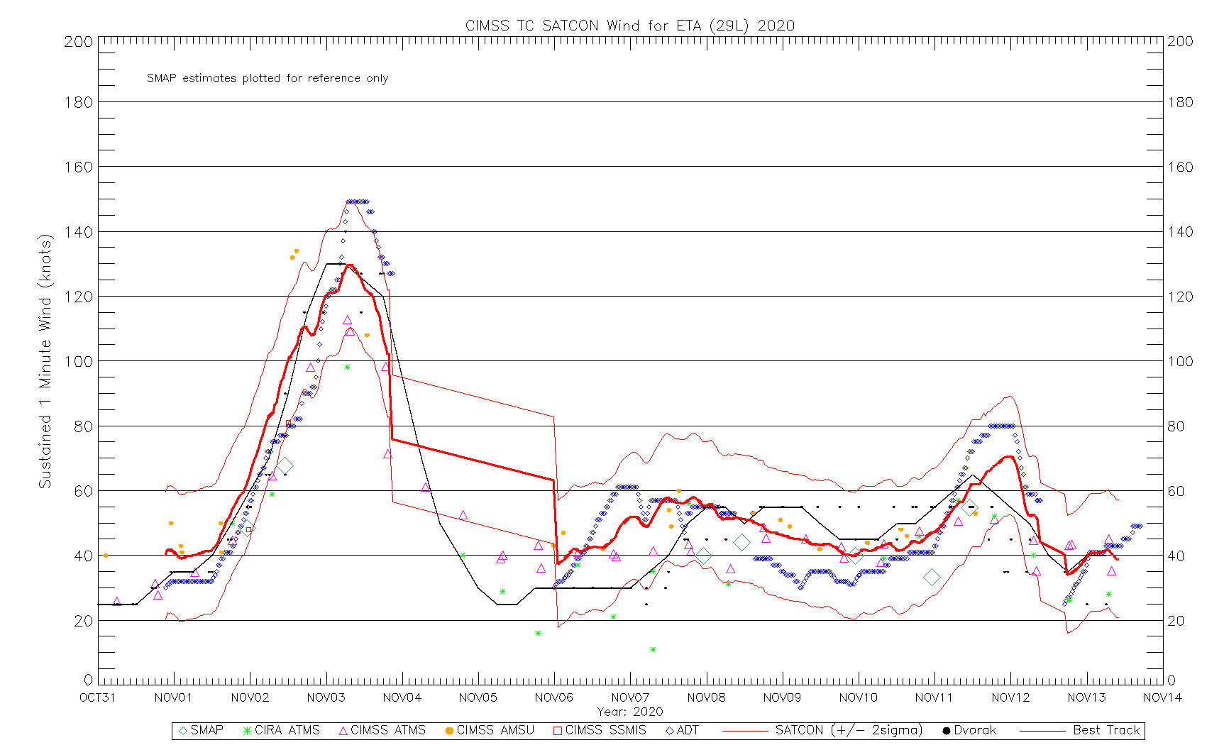
I've had some time to look into Eta some more, and I'm honestly beginning to think the NHC's 130 knot intensity is reasonable. I don't think there's any convincing evidence that it ever reached Category 5 intensity.
The maximum 700mb flight level wind observed by recon was 137 knots (at 2:18 UTC on November 3). The SFMR instrument recorded several values between 124 and 135 knots, though nearly all of them were flagged. The 135 knot SFMR value, in particular, had very high rain rates. It should be noted that the SFMR instrument may have a high bias at extreme intensities. While it is possible recon may have undersampled the maximum winds, it appears unlikely that recon would have found the 148-150+ knot flight level winds that would be needed to justify an upgrade to Category 5 status. Although the northwestern quadrant (the right-front quadrant) was not fully sampled, Eta was not moving particularly fast (about 7 mph), so it is unlikely the northwestern quadrant was significantly stronger than the sampled north side. Eta's central pressure fell approximately 3 mb between the two recon passes that evening. I wouldn't be surprised if Eta's MSLP bottomed out somewhere around 920-922 mb, but I don't think it got any lower than that. Considering Eta was still deepening during that flight, I think it's pretty clear that Eta did not reach Category 5 status prior to that mission. In fact, I wouldn't be surprised to see the 00z point from November 3 revised downward to 125 knots.
It seems unlikely Eta got much stronger after the recon mission late on November 2 left. From the 10:00 p.m. EST discussion on November 2:
By that time, concentric eyewalls were already noted to be possibly forming. Recon left shortly after 03z, and raw T-numbers begun to slowly drop after that time.
From the 4:00 a.m. EST on November 3:
By the 09z public advisory, raw ADT T-values had fallen below 7.0, and NHC notes that radar data suggests Eta has "at least one" concentric eyewall, which has likely stopped the rapid deepening process. NHC claims Dvorak estimates from both TAFB and SAB support an intensity of 130 knots, and there is no mention that this is intensity may be conservative (as we common see). By 12z the next morning, recon had reported the central pressure had risen to 936 mb. It seems likely the weakening trend began sometime around 06z November 3.
Among Dvorak estimates, only the Advanced Dvorak Technique (ADT) supported Category 5 intensity. Raw T numbers in Eta were extremely high - reaching as high as T8.4 at one point around 03:00 UTC November 3 (right around the time recon left). However, subjective estimates from SAB peaked at only T6.5 (about 125-130 knots), and the SATCON consensus only supported around 130 knots as well:http://tropic.ssec.wisc.edu/real-time/satcon/202029L_wind_ssmis.gif
The maximum 700mb flight level wind observed by recon was 137 knots (at 2:18 UTC on November 3). The SFMR instrument recorded several values between 124 and 135 knots, though nearly all of them were flagged. The 135 knot SFMR value, in particular, had very high rain rates. It should be noted that the SFMR instrument may have a high bias at extreme intensities. While it is possible recon may have undersampled the maximum winds, it appears unlikely that recon would have found the 148-150+ knot flight level winds that would be needed to justify an upgrade to Category 5 status. Although the northwestern quadrant (the right-front quadrant) was not fully sampled, Eta was not moving particularly fast (about 7 mph), so it is unlikely the northwestern quadrant was significantly stronger than the sampled north side. Eta's central pressure fell approximately 3 mb between the two recon passes that evening. I wouldn't be surprised if Eta's MSLP bottomed out somewhere around 920-922 mb, but I don't think it got any lower than that. Considering Eta was still deepening during that flight, I think it's pretty clear that Eta did not reach Category 5 status prior to that mission. In fact, I wouldn't be surprised to see the 00z point from November 3 revised downward to 125 knots.
It seems unlikely Eta got much stronger after the recon mission late on November 2 left. From the 10:00 p.m. EST discussion on November 2:
The radar data also suggest that concentric eyewalls may be forming,
which would be an indication of the onset of an eyewall replacement
cycle (ERC) and a capping of Eta's intensity and also an end to the
rapid intensification cycle of the past 36 hours.
which would be an indication of the onset of an eyewall replacement
cycle (ERC) and a capping of Eta's intensity and also an end to the
rapid intensification cycle of the past 36 hours.
By that time, concentric eyewalls were already noted to be possibly forming. Recon left shortly after 03z, and raw T-numbers begun to slowly drop after that time.
From the 4:00 a.m. EST on November 3:
Based on
continuity from the earlier Hurricane Hunter observations and
Dvorak classifications from TAFB and SAB, the current intensity
estimate remains 130 kt. Images from the San Andres radar show
at least one concentric eyewall, and this structure has likely
stopped the rapid deepening process.
continuity from the earlier Hurricane Hunter observations and
Dvorak classifications from TAFB and SAB, the current intensity
estimate remains 130 kt. Images from the San Andres radar show
at least one concentric eyewall, and this structure has likely
stopped the rapid deepening process.
By the 09z public advisory, raw ADT T-values had fallen below 7.0, and NHC notes that radar data suggests Eta has "at least one" concentric eyewall, which has likely stopped the rapid deepening process. NHC claims Dvorak estimates from both TAFB and SAB support an intensity of 130 knots, and there is no mention that this is intensity may be conservative (as we common see). By 12z the next morning, recon had reported the central pressure had risen to 936 mb. It seems likely the weakening trend began sometime around 06z November 3.
Among Dvorak estimates, only the Advanced Dvorak Technique (ADT) supported Category 5 intensity. Raw T numbers in Eta were extremely high - reaching as high as T8.4 at one point around 03:00 UTC November 3 (right around the time recon left). However, subjective estimates from SAB peaked at only T6.5 (about 125-130 knots), and the SATCON consensus only supported around 130 knots as well:http://tropic.ssec.wisc.edu/real-time/satcon/202029L_wind_ssmis.gif
6 likes
NCSU B.S. in Meteorology Class of 2021. Tropical weather blogger at http://www.cyclonicfury.com. My forecasts and thoughts are NOT official, for official forecasts please consult the National Hurricane Center.
-
cycloneye
- Admin
- Posts: 149712
- Age: 69
- Joined: Thu Oct 10, 2002 10:54 am
- Location: San Juan, Puerto Rico
Re: 2020 TCRs
The reports from TD-Ten, yes remained as TD, TS René and EPAC TD-Six-E and TD-Ten-E are up.
0 likes
Visit the Caribbean-Central America Weather Thread where you can find at first post web cams,radars
and observations from Caribbean basin members Click Here
and observations from Caribbean basin members Click Here
-
CyclonicFury
- Category 5
- Posts: 2038
- Age: 27
- Joined: Sun Jul 02, 2017 12:32 pm
- Location: NC
- Contact:
Re: 2020 TCRs
Rene was actually downgraded from 45 to 40 knots, which seems reasonable since ASCAT data never supported an intensity that high.
1 likes
NCSU B.S. in Meteorology Class of 2021. Tropical weather blogger at http://www.cyclonicfury.com. My forecasts and thoughts are NOT official, for official forecasts please consult the National Hurricane Center.
-
ElectricStorm
- Category 5
- Posts: 5155
- Age: 25
- Joined: Tue Aug 13, 2019 11:23 pm
- Location: Norman, OK
Re: 2020 TCRs
Now that we're past the holidays, I would imagine these reports will start coming out pretty quickly, especially the weaker storms like the ones released today.
0 likes
B.S Meteorology, University of Oklahoma '25
Please refer to the NHC, NWS, or SPC for official information.
Please refer to the NHC, NWS, or SPC for official information.
Re: 2020 TCRs
CyclonicFury wrote:Rene was actually downgraded from 45 to 40 knots, which seems reasonable since ASCAT data never supported an intensity that high.
Poor Rene. It had pretty decent potential, but even with low shear, it constantly struggled with dry air and fell WAY below the NHC forecast intensity estimates.
I’m guessing Vicky and Wilfred’s TCRs should be coming out soon, since they were very similar to Rene: weak and unimpressive slop MDR storms in September. They shouldn’t need much time devoted to them.
0 likes
Irene '11 Sandy '12 Hermine '16 5/15/2018 Derecho Fay '20 Isaias '20 Elsa '21 Henri '21 Ida '21
I am only a meteorology enthusiast who knows a decent amount about tropical cyclones. Look to the professional mets, the NHC, or your local weather office for the best information.
I am only a meteorology enthusiast who knows a decent amount about tropical cyclones. Look to the professional mets, the NHC, or your local weather office for the best information.
-
ElectricStorm
- Category 5
- Posts: 5155
- Age: 25
- Joined: Tue Aug 13, 2019 11:23 pm
- Location: Norman, OK
Re: 2020 TCRs
aspen wrote:CyclonicFury wrote:Rene was actually downgraded from 45 to 40 knots, which seems reasonable since ASCAT data never supported an intensity that high.
Poor Rene. It had pretty decent potential, but even with low shear, it constantly struggled with dry air and fell WAY below the NHC forecast intensity estimates.
I’m guessing Vicky and Wilfred’s TCRs should be coming out soon, since they were very similar to Rene: weak and unimpressive slop MDR storms in September. They shouldn’t need much time devoted to them.
Yeah Rene was definitely the underperformance of the year. It's a shame since it had potential to be a solid fish storm, but nope, it couldn't get the job done in only 10kts of shear, while Paulette had 40kts of shear and survived.
1 likes
B.S Meteorology, University of Oklahoma '25
Please refer to the NHC, NWS, or SPC for official information.
Please refer to the NHC, NWS, or SPC for official information.
-
cycloneye
- Admin
- Posts: 149712
- Age: 69
- Joined: Thu Oct 10, 2002 10:54 am
- Location: San Juan, Puerto Rico
Re: 2020 TCRs
From report on why they didn't upgrade TD Ten to TS.
Although an ASCAT-B pass around 2300 UTC 31 July
showed maximum winds around 35 kt, these winds appear to be rain inflated and were located in
the southwest quadrant of the circulation, an area where you would not expect to find the
maximum winds in a northwestward moving tropical cyclone.
showed maximum winds around 35 kt, these winds appear to be rain inflated and were located in
the southwest quadrant of the circulation, an area where you would not expect to find the
maximum winds in a northwestward moving tropical cyclone.
3 likes
Visit the Caribbean-Central America Weather Thread where you can find at first post web cams,radars
and observations from Caribbean basin members Click Here
and observations from Caribbean basin members Click Here

Re: 2020 TCRs
Weather Dude wrote:aspen wrote:CyclonicFury wrote:Rene was actually downgraded from 45 to 40 knots, which seems reasonable since ASCAT data never supported an intensity that high.
Poor Rene. It had pretty decent potential, but even with low shear, it constantly struggled with dry air and fell WAY below the NHC forecast intensity estimates.
I’m guessing Vicky and Wilfred’s TCRs should be coming out soon, since they were very similar to Rene: weak and unimpressive slop MDR storms in September. They shouldn’t need much time devoted to them.
Yeah Rene was definitely the underperformance of the year. It's a shame since it had potential to be a solid fish storm, but nope, it couldn't get the job done in only 10kts of shear, while Paulette had 40kts of shear and survived.
Really shows how much of a dent the monsoon trough location put in 2020's MDR activity. Even Paulette, which survived by being further west, was flung north over cooler waters and into the shear wall as it rotated around it.
0 likes
The above post is not official and should not be used as such. It is the opinion of the poster and may or may not be backed by sound meteorological data. It is not endorsed by any professional institution or storm2k.org. For official information, please refer to the NHC and NWS products.
-
cycloneye
- Admin
- Posts: 149712
- Age: 69
- Joined: Thu Oct 10, 2002 10:54 am
- Location: San Juan, Puerto Rico
Re: 2020 TCRs
Tropical Storm Cristobal is up.
0 likes
Visit the Caribbean-Central America Weather Thread where you can find at first post web cams,radars
and observations from Caribbean basin members Click Here
and observations from Caribbean basin members Click Here
Who is online
Users browsing this forum: Ed_2001, pepecool20 and 206 guests