The Euro and GFS show very weak trades if not westerly winds in the EPAC for a little while. Likely won't do much to change anything but Nino regions 3 and 1+2 should start warming up soon.
Moderator: S2k Moderators


cycloneye wrote:Indeed, La Niña does not look to go away anytime soon.
https://i.imgur.com/Tadaky1.png


cycloneye wrote:https://twitter.com/bhensonweather/status/1346260204275572739

Kingarabian wrote:Anyone know when ONI will be updated? I remember in a blog from the CPC back in Spring 2020 that they said they are confident that the ONI update will nerf the warm tri-monthlies and will not support an El Nino event for 2020. Curious to see if this will happen or not.
cycloneye wrote:Kingarabian wrote:Anyone know when ONI will be updated? I remember in a blog from the CPC back in Spring 2020 that they said they are confident that the ONI update will nerf the warm tri-monthlies and will not support an El Nino event for 2020. Curious to see if this will happen or not.
Here is the OND update at -1.3C.
https://origin.cpc.ncep.noaa.gov/produc ... ONI_v5.php
Finally, there’s another issue that is likely coming into play here. The tropical Pacific is experiencing climate change along with the rest of the world, and it’s affecting the “average.” What counts as “average” is getting warmer over time. NOAA uses a 30-year period to define average, and right now that is 1986–2015 for the Oceanic Niño Index. In January of 2021, we’ll update the average period to 1991–2020. Lots more detail here and here.
This update will result in changes to the ONI values dating back to 2006. Some seasons that were warm enough to qualify as El Niño when compared to the older (cooler) average won’t be when compared to the more recent (warmer) average. Since winter 2019–2020 was right on the edge, it’s likely that at least one season will drop to 0.4°C, and we’ll no longer have five consecutive seasons at or above the El Niño threshold.
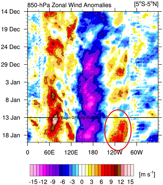


Kingarabian wrote:GFS and Euro show a moderate and expansive EPAC WWB that will last for 2 weeks.
https://i.postimg.cc/6QRnb7Fg/gfsw-wbs.png
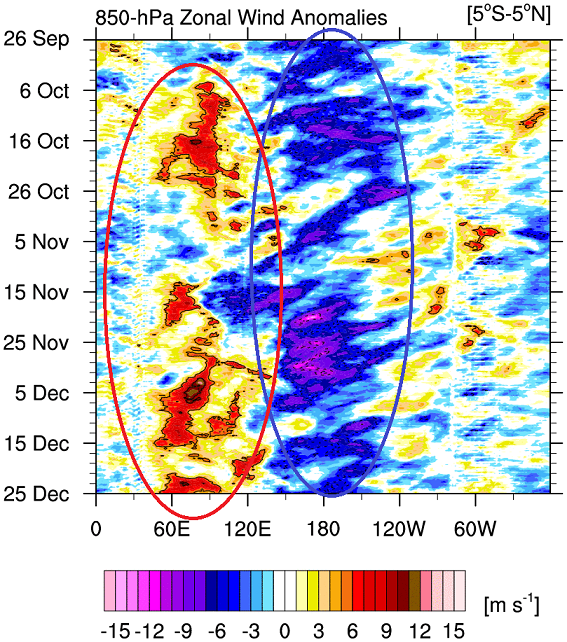
In regards to ENSO what matters most is the wind anomalies near the dateline @ 180. Even in the 850mb wind charts It's clear and obvious that La Nina is in full control. But this EPAC WWB will help to slow down upwelling over the Nino 3+4, Nino 3, and Nino 1+2 regions. It looks substantial enough to bring SST anomalies in those regions back to neutral because it will also have help from a downwelling Kelvin wave. In the next few months current downwelling Kelvin wave should be in the CPAC and EPAC. Some of those anomalies will reach the surface and it's possible to see positive anomalies by mid/end of Spring.
After that time it's very unlikely we'll see any more downwelling Kelvin waves because the base state is clearly La Nina. As we enter the summer, the July trades should come back and help the La Nina recover. For reference, this is what happened in 2012 and 2017.


Kingarabian wrote:Looking at the subsurface, since the summer there has been downwelling Kelvin waves developing but getting shunted before reaching the dateline. That's due to the prolonged strong trades near the dateline. Have to watch and see what happens in December and January, if trades can slow down and this ample amount of subsurface warmth can breach 180 and get to the CPAC.
https://i.imgur.com/OGDzwMS.png
cycloneye wrote:CPC January update has La Niña dominating but a possible change to ENSO Neutral may occur by late Spring or Summer. Notice that the blue line that is La Niña goes up slightly by JAS and ASO.
https://i.imgur.com/2SMW1EE.png
https://www.cpc.ncep.noaa.gov/products/ ... disc.shtml
Users browsing this forum: Google Adsense [Bot] and 45 guests