
 Looking like February is gonna kick things off on quite the chilly side with this next front this Monday. Tuesday morning lows should dip into the 30's for much of North & Central. Beautiful beach weather Tuesday & Wednesday (for Eskimo's
 Florida Weather
Moderator: S2k Moderators
Forum rules

The posts in this forum are NOT official forecast and should not be used as such. They are just the opinion of the poster and may or may not be backed by sound meteorological data. They are NOT endorsed by any professional institution or STORM2K.
Re: Florida Weather
Looking like February is gonna kick things off on quite the chilly side with this next front this Monday. Tuesday morning lows should dip into the 30's for much of North & Central. Beautiful beach weather Tuesday & Wednesday (for Eskimo's
0 likes
Andy D
(For official information, please refer to the NHC and NWS products.)
(For official information, please refer to the NHC and NWS products.)
Re: Florida Weather
Good cool shot incoming for sure. Sub 60 high already in NWS forecast for Tuesday. Looks like a typical windy, chilly invasion we've seen many times this winter. Looks like a southeast ridge is showing up long term while the west gets the cold..
0 likes
-
gatorcane

- S2K Supporter

- Posts: 23708
- Age: 48
- Joined: Sun Mar 13, 2005 3:54 pm
- Location: Boca Raton, FL
Re: Florida Weather
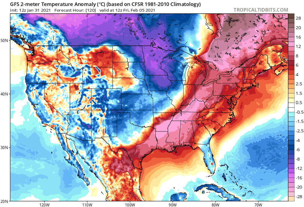
The GFS has trended towards possibly the strongest front of the season so far in the medium-range going colder than the previous runs. Looks like arctic air straight from Canada. This is the next front to watch after the one this week which will be cold for the peninsula as well
0 likes
-
gatorcane
- S2K Supporter
- Posts: 23708
- Age: 48
- Joined: Sun Mar 13, 2005 3:54 pm
- Location: Boca Raton, FL
Re: Florida Weather
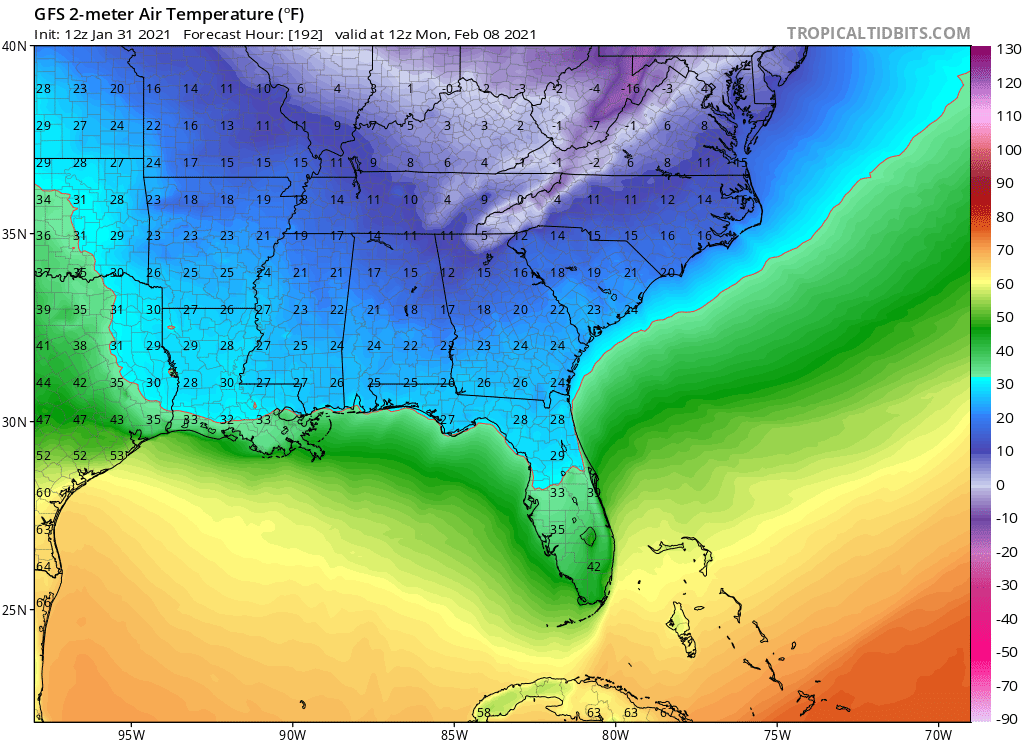
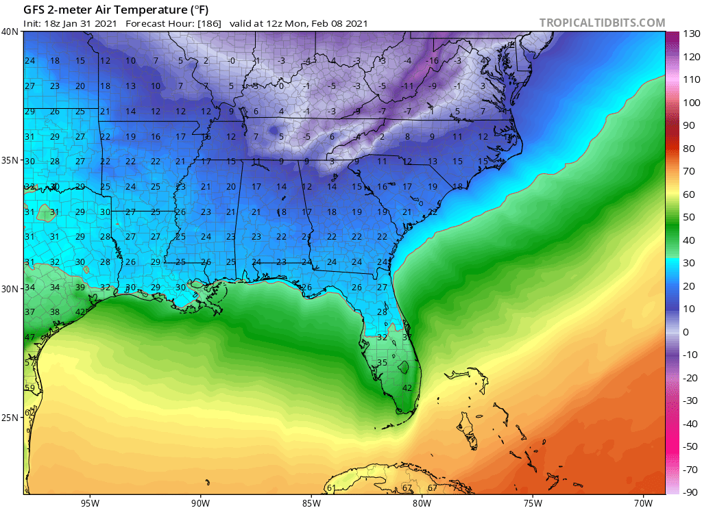
12Z Euro with a freeze for parts of the Tampa area even into (northern) Pinellas County (32) as well as Orlando (32) for the next front (192 hours) 
Obviously plenty of time for things to change but bears watching with both reliable models on board.
Obviously plenty of time for things to change but bears watching with both reliable models on board.
1 likes
Re: Florida Weather
0 likes
Re: Florida Weather
gatorcane wrote:12Z Euro with a freeze for parts of the Tampa area even into (northern) Pinellas County (32) as well as Orlando (32) for the next front (192 hours)
Obviously plenty of time for things to change but bears watching with both reliable models on board.
definitely worth watching and I will certainly be tuned in. We haven't even had a scare this year...no freeze or frost headlines at all. And January is cashed in
Last edited by psyclone on Sun Jan 31, 2021 2:23 pm, edited 1 time in total.
0 likes
-
gatorcane
- S2K Supporter
- Posts: 23708
- Age: 48
- Joined: Sun Mar 13, 2005 3:54 pm
- Location: Boca Raton, FL
Re: Florida Weather
When the GFS has support from the Euro and we are talking medium range and not fantasy range, chances do go up of a significant cold front week after this week. Will there be a freeze into Central Florida? Maybe not but winter over doesn’t seem the call yet at this point.
Also one thing to note, the Super Bowl may be impacted by the front so we will have to keep an eye on that.
3 likes
Re: Florida Weather
gatorcane wrote::uarrow:
When the GFS has support from the Euro and we are talking medium range and not fantasy range, chances do go up of a significant cold front week after this week. Will there be a freeze into Central Florida? Maybe not but winter-cancel doesn’t seem the call yet at this point.
Also one thing to note, the Super Bowl may be impacted by the front so we will have to keep an eye on that.
well it is fair to say that there's a lot of cold in the cannon so we'll see. I will be watching the CPC maps with interest to see if those recently depicted warm anoms fade away. If they do...i will get a lot more intrigued.
0 likes
-
toad strangler

- S2K Supporter
- Posts: 4546
- Joined: Sun Jul 28, 2013 3:09 pm
- Location: Earth
- Contact:
Re: Florida Weather
gatorcane wrote::uarrow:
When the GFS has support from the Euro and we are talking medium range and not fantasy range, chances do go up of a significant cold front week after this week. Will there be a freeze into Central Florida? Maybe not but winter over doesn’t seem the call yet at this point.
Also one thing to note, the Super Bowl may be impacted by the front so we will have to keep an eye on that.
This one has legs. I'm tuned in. It's been a very easy past month and a half on my AC system and looks like that streak grows.
1 likes
My Weather Station
https://www.wunderground.com/dashboard/pws/KFLPORTS603
https://www.wunderground.com/dashboard/pws/KFLPORTS603
Re: Florida Weather
we are definitely in an active pattern with lots of storm action and cold up north...and if the stars align we can get serious chill yanked down here. plus we coming into peak climo for noreasters in the mid atlantic and northeast...which do well swinging strong cold fronts this way
0 likes
Re: Florida Weather
well the CPC outlooks definitely trended cooler compared to yesterday...it's a trend worth watching
0 likes
-
gatorcane
- S2K Supporter
- Posts: 23708
- Age: 48
- Joined: Sun Mar 13, 2005 3:54 pm
- Location: Boca Raton, FL
Re: Florida Weather
18Z GFS has trended a little colder as well with the freeze line deeper into Central Florida right along the I-4 corridor. Lines up with the Euro quite well actually.
0 likes
Re: Florida Weather
psyclone wrote::uarrow: your last post (1-16) was a GFS fantasty freeze scheduled for 1-28. It didn't happen. not even close. Why should anyone believe this one? I'm sure it's possible...but the number of false alarms has savaged the cred of the long term GFS. CPC has been depicting a southeast ridge with the cold dominating the west and the north. That's more believable long term...but the cold is strong enough to keep an eye on for sure. Meanwhile...we are running the clock out on winter as the great pollen storm has commenced.. In the near term...the current cold front is going to be solid with lots wind and chilly weather...mid to upper 50's on Tuesday for a max in the bay area..but no freeze and a late week warming trend..
I think I view that 12 day long range forecast you referenced as having been a bit more "GFS-half full" LOL. I mean c'mon, 4 days and perhaps 6 degrees off is hardly a whiff in my book. I've learned quite some time ago to view any long range forecast as more of a fuzzy view into the future rather then a literal proclamation. As for that next possible arctic front, i'm apt to think it'll be mid-upper 30 lows & upper 50 highs for Central Florida. Then again...... if it turns out to be a couple days sooner or later, or a tad colder or warmer.... what's a few degrees between friends
0 likes
Andy D
(For official information, please refer to the NHC and NWS products.)
(For official information, please refer to the NHC and NWS products.)
Re: Florida Weather
I could be wrong but it seems the GFS gets a tad ahead of itself wrt cold invasions. It's interesting that we have had many chilly days and nights with no freeze threats...so far. I'm hoping the trend continues. I have kind of enjoyed the chill this year..even though it's not my first choice. Hoodie/comfort food weather is pretty good stuff. As for some legit cold in the pipeline...I need to see it to believe it...too many long range fake outs. But watching with interest as always.
0 likes
-
NotSparta

- Professional-Met

- Posts: 1677
- Age: 24
- Joined: Fri Aug 18, 2017 8:24 am
- Location: Naples, FL
- Contact:
Re: Florida Weather
Man, I'm missing last winter, lol. Not a fan of the frequent cold. I preferred the warmth we had like a week ago
1 likes
This post was probably an opinion of mine, and in no way is official. Please refer to http://www.hurricanes.gov for official tropical analysis and advisories.
My website, with lots of tropical wx graphics, including satellite and recon: http://cyclonicwx.com
My website, with lots of tropical wx graphics, including satellite and recon: http://cyclonicwx.com
Re: Florida Weather
NotSparta wrote:Man, I'm missing last winter, lol. Not a fan of the frequent cold. I preferred the warmth we had like a week ago
No kidding. Warm weather fans cashed in with about 4 or 5 consecutive torches before this year. Now even a "near normal" winter feels cold. At least we're past peak freeze season and headed in the right direction over time
1 likes
Re: Florida Weather
gatorcane wrote:12Z Euro with a freeze for parts of the Tampa area even into (northern) Pinellas County (32) as well as Orlando (32) for the next front (192 hours)
Obviously plenty of time for things to change but bears watching with both reliable models on board.
Next weekend's Arctic outbreak will certainly contain significantly colder air for much of the E. CONUS. So far though I am not seeing either the EURO or GFS (0Z or 6Z) projecting those low-low 500mb heights being nearly as sharp and far south for late next weekend, as our present early week cold intrusion that we're about to experience today through Wednesday. In plain English, next weekend's cold air affecting most of E. CONUS would certainly be in place to potentially put Florida into the "deep-freeze" but so far I'm not seeing the mid level transport system presently forecast to actually bring that colder air down here yet. Regardless, cold air advection will still bring down more cold air to our peninsula but a practically zonal west to east mid level flow over most of Florida would blunt night time temps from being anywhere as cold as a northwesterly or northerly mid level flow potentially could. That could change of course and we'll have to see if updated model runs trend status quo or begin to suggest sharper and lowered height troughing as far south as Florida. Last week I saw repetitious 500mb forecasts suggesting the widespread night-time temps into the 30's for much of Florida and here we are now. Seems like the Melbourne NWS was a bit slow to "bite" on forecasting these low temps out of suspicion that models would back off on their previous weeks suggestion that such sharp troughing would extend as far south as it is now.
0 likes
Andy D
(For official information, please refer to the NHC and NWS products.)
(For official information, please refer to the NHC and NWS products.)
Re: Florida Weather
6-10 day flips blue but keeps the extreme low anomalies over the midwest. Hopefully we squeak by with a glancing blow like we have so far this winter...
0 likes
Re: Florida Weather
Holy smokes is it chilly out. Not seeing any apocalyptic GFS maps. that must be good news. Come on Spring!
0 likes
-
HURRICANELONNY
- Category 5

- Posts: 1392
- Joined: Wed May 07, 2003 6:48 am
- Location: HOLLYWOOD.FL
Re: Florida Weather
Nice and cool tonight. Windows will be closed though. 40's a little too cold for open windows down here. As for next week. I haven't looked at the globals but it looks like right now, not as cold as this front. According to the Miami NWS:
Global models then depict cyclogenesis off the mid-Atlantic coast
in response to an upper level jet streak, which allows for a
secondary boundary to develop and aid the first front in pushing
across South Florida early next week. There are no present
indications cooler air returns behind this next front, but keep in
mind, details are subject to change given the usual variability
between guidance members in timing/location/intensity/impacts this
far out.
0 likes
hurricanelonny
Return to “USA & Caribbean Weather”
Who is online
Users browsing this forum: Greener and 100 guests