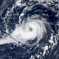
The NOAA SAB classified this system as a tropical storm. https://www.ssd.noaa.gov/PS/TROP/storms/01Q.html
The ASCAS passes missed the cyclone in the daytime but around 00 UTC they measured maximum winds around 40 kt, however they suggested that the circulation still was connected with the front. But based on the satellite animation, indeed it looks like that it aquired more tropical chaaracteristics for a short time, before the convection started to weakening in the late afternoon hours.
SATL: 01Q
Moderator: S2k Moderators
- Vince_and_Grace_fan
- Category 1
- Posts: 316
- Joined: Thu Nov 03, 2016 9:25 am
- Location: Szombathely (Hungary)
SATL: 01Q
5 likes
Re: SATL: 01Q
Nice post
Weak, but looks purely tropical on satellite. Compact wind field, pressure field, and a (small) plume of convection over the center. Though heavily sheared with almost all of its convection in a relatively small area on the south side, this is one of the most impressive looking system in the south Atlantic in years. Most are rather disorganized borderline subtropical systems.
However, like most south Atlantic systems- it will have a short life: GFS is showing it getting blown to the southeast and get absorbed into a frontal system tomorrow morning.
This is one of many systems forming in the south Atlantic in the past 10 years. In the 1990s and 2000s there were hardly any, while there has been a significant uptick around 2010 or 2015. Has the south Atlantic become more active or is it simply that more are getting recognition? If it has gotten more active, why could that be? I am not a statistician but I think the South Atlantic will see another hurricane within 20-30 years.
1 likes
All posts by Dean_175 are NOT official forecasts and should not be used as such. They are just the opinion of the poster and may or may not be backed by sound meteorological data. They are NOT endorsed by any professional institution or storm2k.org. For official information, please refer to the NHC and NWS products.
-
- Category 5
- Posts: 8788
- Age: 38
- Joined: Thu Jul 06, 2017 1:51 am
Re: SATL: 01Q
Looks better then any of the systems upgraded and named by the south American meteorological agency last year.
1. Looks subtropical in wind field
2. At least some convection near the center.
3. Isn't super clear that it is attached to any front to me. IMO.
should have gotten named.
1. Looks subtropical in wind field
2. At least some convection near the center.
3. Isn't super clear that it is attached to any front to me. IMO.
should have gotten named.
2 likes
- Vince_and_Grace_fan
- Category 1
- Posts: 316
- Joined: Thu Nov 03, 2016 9:25 am
- Location: Szombathely (Hungary)
Re: SATL: 01Q
Yes, it is interesting that the Brasilian met. service didn't name this system since they classified much more disorganized and extratropical-looking systems as a subtropical storm in the past. There was also a similar (and a bit more tropical) looking cyclone in last March which didn't got classification. [Youtube]https://www.youtube.com/watch?v=Uz5PZN4V6u8[/Youtube]
In this case, there was a long occlusion front near the small cyclone, but it is questionable how it was attached to each other. The ASCAT pass at 22:50 UTC indicated that the circulation had some connection with the front. So it was at least subtropical, and maybe tropical for a short time.
Dean_175: I think that this basin is very similar to the Mediterranean Sea. It is very likely that subtropical and rarely tropical cyclone occurred in the past too, but they hadn't got attention. But some true increase in the numbers of storms are possible in the last years, most likely due to the warming of the ocean, but it is worth to noting that like in the MED basin, the mid and upper level conditions (mostly the strong wind shear or the dry air) often limited the development. And since blocking pattern is needed for the development in the SATL, maybe these also have became more common.
0 likes
Who is online
Users browsing this forum: No registered users and 0 guests