2021 Indicators: SST's / SAL / MSLP / Shear / Steering / Instability / Sat Images
Moderator: S2k Moderators
Forum rules

The posts in this forum are NOT official forecasts and should not be used as such. They are just the opinion of the poster and may or may not be backed by sound meteorological data. They are NOT endorsed by any professional institution or STORM2K. For official information, please refer to products from the National Hurricane Center and National Weather Service.
-
BYG Jacob
Re: 2021 Indicators: SST's / SAL / MSLP / Shear / Steering / Instability / Sat Images
Gonna be another long year
1 likes
-
Iceresistance

- Category 5

- Posts: 9592
- Age: 22
- Joined: Sat Oct 10, 2020 9:45 am
- Location: Tecumseh, OK/Norman, OK
Re: 2021 Indicators: SST's / SAL / MSLP / Shear / Steering / Instability / Sat Images
End of April SST Anomalies in the Atlantic, this is not looking good . . .

6 likes
Bill 2015 & Beta 2020
Winter 2020-2021
All observations are in Tecumseh, OK unless otherwise noted.
Winter posts are focused mainly for Oklahoma & Texas.
Take any of my forecasts with a grain of salt, refer to the NWS, SPC, and NHC for official information
Never say Never with weather! Because ANYTHING is possible!
Winter 2020-2021
All observations are in Tecumseh, OK unless otherwise noted.
Winter posts are focused mainly for Oklahoma & Texas.
Take any of my forecasts with a grain of salt, refer to the NWS, SPC, and NHC for official information
Never say Never with weather! Because ANYTHING is possible!
-
Category5Kaiju

- Category 5
- Posts: 4335
- Joined: Thu Dec 24, 2020 12:45 pm
- Location: Seattle during the summer, Phoenix during the winter
Re: 2021 Indicators: SST's / SAL / MSLP / Shear / Steering / Instability / Sat Images
Iceresistance wrote:End of April SST Anomalies in the Atlantic, this is not looking good . . .
https://s3.gifyu.com/images/crw_ssta_natl.png
That Canary Current is clearly abnormally warm; also Atlantic Nino 3 is expected to significantly warm up in the coming months; currently the sst anomalies off the west coast of Africa south of the equator are also quite high.
1 likes
Unless explicitly stated, all information in my posts is based on my own opinions and observations. Tropical storms and hurricanes can be extremely dangerous. Refer to an accredited weather research agency or meteorologist if you need to make serious decisions regarding an approaching storm.
-
Shell Mound
- Category 5
- Posts: 2432
- Age: 33
- Joined: Thu Sep 07, 2017 3:39 pm
- Location: St. Petersburg, FL → Scandinavia
Re: 2021 Indicators: SST's / SAL / MSLP / Shear / Steering / Instability / Sat Images
4 likes
CVW / MiamiensisWx / Shell Mound
The posts in this forum are NOT official forecasts and should not be used as such. They are just the opinion of the poster and may or may not be backed by sound meteorological data. They are NOT endorsed by any professional institution or STORM2K. For official information, please refer to products from the NHC and NWS.
-
AutoPenalti
- Category 5
- Posts: 4091
- Age: 29
- Joined: Mon Aug 17, 2015 4:16 pm
- Location: Ft. Lauderdale, Florida
Re: 2021 Indicators: SST's / SAL / MSLP / Shear / Steering / Instability / Sat Images
SFLcane wrote:For those of us in SFL better hope this isn't correct with regards to the CFS. The mean position of the trough in August is basically the same as Irma in 2017. Lots of time still but an eye opener for sure.
https://i.imgur.com/BuB5LPk.png
https://i.imgur.com/FVqjCKB.png
That is NOT. GOOD.
0 likes
The posts in this forum are NOT official forecasts and should not be used as such. They are just the opinion of the poster and may or may not be backed by sound meteorological data. They are NOT endorsed by any professional institution or STORM2K. For official information, please refer to products from the NHC and NWS.
Model Runs Cheat Sheet:
GFS (5:30 AM/PM, 11:30 AM/PM)
HWRF, GFDL, UKMET, NAVGEM (6:30-8:00 AM/PM, 12:30-2:00 AM/PM)
ECMWF (1:45 AM/PM)
TCVN is a weighted averaged
-
AutoPenalti
- Category 5
- Posts: 4091
- Age: 29
- Joined: Mon Aug 17, 2015 4:16 pm
- Location: Ft. Lauderdale, Florida
Re: 2021 Indicators: SST's / SAL / MSLP / Shear / Steering / Instability / Sat Images
0 likes
The posts in this forum are NOT official forecasts and should not be used as such. They are just the opinion of the poster and may or may not be backed by sound meteorological data. They are NOT endorsed by any professional institution or STORM2K. For official information, please refer to products from the NHC and NWS.
Model Runs Cheat Sheet:
GFS (5:30 AM/PM, 11:30 AM/PM)
HWRF, GFDL, UKMET, NAVGEM (6:30-8:00 AM/PM, 12:30-2:00 AM/PM)
ECMWF (1:45 AM/PM)
TCVN is a weighted averaged

Re: 2021 Indicators: SST's / SAL / MSLP / Shear / Steering / Instability / Sat Images
AutoPenalti wrote:https://twitter.com/tropicalblognet/status/1387492549254844419
Woah, the ITCZ is really far south. Does its position at this time of year have any impact on its position by ASO?
0 likes
Irene '11 Sandy '12 Hermine '16 5/15/2018 Derecho Fay '20 Isaias '20 Elsa '21 Henri '21 Ida '21
I am only a meteorology enthusiast who knows a decent amount about tropical cyclones. Look to the professional mets, the NHC, or your local weather office for the best information.
I am only a meteorology enthusiast who knows a decent amount about tropical cyclones. Look to the professional mets, the NHC, or your local weather office for the best information.
-
DorkyMcDorkface

- Category 5
- Posts: 1019
- Age: 28
- Joined: Mon Sep 30, 2019 1:32 pm
- Location: Mid-Atlantic
Re: 2021 Indicators: SST's / SAL / MSLP / Shear / Steering / Instability / Sat Images
aspen wrote:AutoPenalti wrote:https://twitter.com/tropicalblognet/status/1387492549254844419
Woah, the ITCZ is really far south. Does its position at this time of year have any impact on its position by ASO?
It's actually only slightly S of average at the present time.


It's going to continue to gradually rise into the summer so the current position doesn't hold too much significance really. At the same time though you don't want the ITCZ to come too far north because that's how you get potent SAL outbreaks in addition to waves running into cooler SSTs.
3 likes
Please note the thoughts expressed by this account are solely those of the user and are from a hobbyist perspective. For more comprehensive analysis, consult an actual professional meteorologist or meteorological agency.
Floyd 1999 | Isabel 2003 | Hanna 2008 | Irene 2011 | Sandy 2012 | Isaias 2020
-
AutoPenalti
- Category 5
- Posts: 4091
- Age: 29
- Joined: Mon Aug 17, 2015 4:16 pm
- Location: Ft. Lauderdale, Florida
Re: 2021 Indicators: SST's / SAL / MSLP / Shear / Steering / Instability / Sat Images
I just thought of something, wouldn't the ITCZ being further north combined with an active WAM also create stronger outbreaks of SAL?
0 likes
The posts in this forum are NOT official forecasts and should not be used as such. They are just the opinion of the poster and may or may not be backed by sound meteorological data. They are NOT endorsed by any professional institution or STORM2K. For official information, please refer to products from the NHC and NWS.
Model Runs Cheat Sheet:
GFS (5:30 AM/PM, 11:30 AM/PM)
HWRF, GFDL, UKMET, NAVGEM (6:30-8:00 AM/PM, 12:30-2:00 AM/PM)
ECMWF (1:45 AM/PM)
TCVN is a weighted averaged
-
Category5Kaiju
- Category 5
- Posts: 4335
- Joined: Thu Dec 24, 2020 12:45 pm
- Location: Seattle during the summer, Phoenix during the winter
Re: 2021 Indicators: SST's / SAL / MSLP / Shear / Steering / Instability / Sat Images
AutoPenalti wrote:I just thought of something, wouldn't the ITCZ being further north combined with an active WAM also create stronger outbreaks of SAL?
I think that's what happened last year? Although I am not quite so sure about how last year compares with 2005 in that aspect; at least in 2005 the SAL seemed to not be an issue one bit as two major storms in July occurred.
0 likes
Unless explicitly stated, all information in my posts is based on my own opinions and observations. Tropical storms and hurricanes can be extremely dangerous. Refer to an accredited weather research agency or meteorologist if you need to make serious decisions regarding an approaching storm.
-
NotSparta

- Professional-Met

- Posts: 1677
- Age: 24
- Joined: Fri Aug 18, 2017 8:24 am
- Location: Naples, FL
- Contact:
Re: 2021 Indicators: SST's / SAL / MSLP / Shear / Steering / Instability / Sat Images
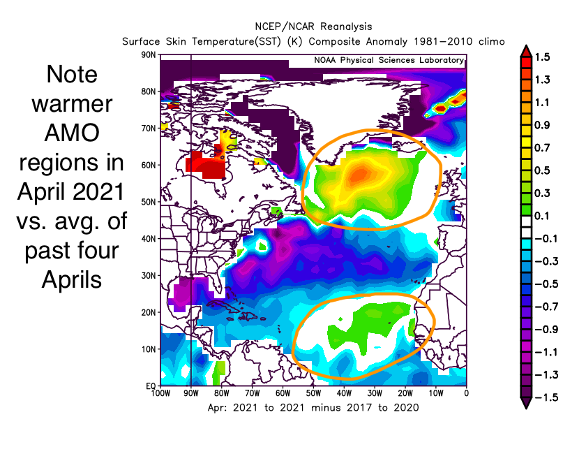
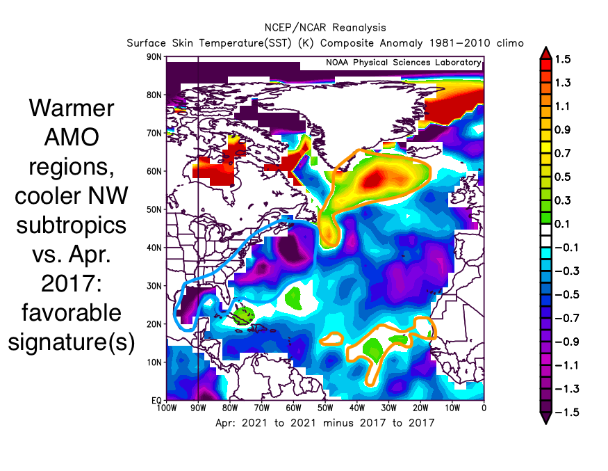
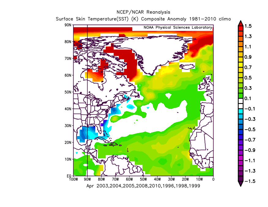
April data isn't quite available yet so you're just comparing to a blank map for now. See April 2017-20:

We'll have to check back with this once the data becomes available in a few days. I, for one, am expecting it is warmer where the Canary current is than it has been the past few years in the data
3 likes
This post was probably an opinion of mine, and in no way is official. Please refer to http://www.hurricanes.gov for official tropical analysis and advisories.
My website, with lots of tropical wx graphics, including satellite and recon: http://cyclonicwx.com
My website, with lots of tropical wx graphics, including satellite and recon: http://cyclonicwx.com
-
cycloneye

- Admin

- Posts: 149508
- Age: 69
- Joined: Thu Oct 10, 2002 10:54 am
- Location: San Juan, Puerto Rico
Re: 2021 Indicators: SST's / SAL / MSLP / Shear / Steering / Instability / Sat Images
Big dust storm in Central Africa and now we wait to see if it emerges Africa so dense like this.
https://twitter.com/RAM_meteo/status/1388482862727446529
https://twitter.com/RAM_meteo/status/1388484158423453698
https://twitter.com/RAM_meteo/status/1388482862727446529
https://twitter.com/RAM_meteo/status/1388484158423453698
1 likes
Visit the Caribbean-Central America Weather Thread where you can find at first post web cams,radars
and observations from Caribbean basin members Click Here
and observations from Caribbean basin members Click Here
-
SFLcane

- S2K Supporter

- Posts: 10281
- Age: 48
- Joined: Sat Jun 05, 2010 1:44 pm
- Location: Lake Worth Florida
Re: 2021 Indicators: SST's / SAL / MSLP / Shear / Steering / Instability / Sat Images
Status quo… busy season still looks very likely. With the steering on the CFS I am quite concerned for Florida this year.
https://twitter.com/bennollweather/status/1388523356069105665
https://twitter.com/bennollweather/status/1388523356069105665
1 likes
-
toad strangler

- S2K Supporter
- Posts: 4546
- Joined: Sun Jul 28, 2013 3:09 pm
- Location: Earth
- Contact:
Re: 2021 Indicators: SST's / SAL / MSLP / Shear / Steering / Instability / Sat Images
SFLcane wrote:For those of us in SFL better hope this isn't correct with regards to the CFS. The mean position of the trough in August is basically the same as Irma in 2017. Lots of time still but an eye opener for sure.
https://i.imgur.com/BuB5LPk.png
https://i.imgur.com/FVqjCKB.png

But will be fully prepped by July that's for sure. As we all should be no matter the long range forecast
0 likes
My Weather Station
https://www.wunderground.com/dashboard/pws/KFLPORTS603
https://www.wunderground.com/dashboard/pws/KFLPORTS603
-
AnnularCane

- S2K Supporter
- Posts: 2962
- Joined: Thu Jun 08, 2006 9:18 am
- Location: Wytheville, VA
Re: 2021 Indicators: SST's / SAL / MSLP / Shear / Steering / Instability / Sat Images
Two weeks till the first TWOs come out.
Barring any surprises.
Barring any surprises.
0 likes
"But it never rained rain. It never snowed snow. And it never blew just wind. It rained things like soup and juice. It snowed mashed potatoes and green peas. And sometimes the wind blew in storms of hamburgers." -- Judi Barrett, Cloudy with a Chance of Meatballs
-
Shell Mound
- Category 5
- Posts: 2432
- Age: 33
- Joined: Thu Sep 07, 2017 3:39 pm
- Location: St. Petersburg, FL → Scandinavia
Re: 2021 Indicators: SST's / SAL / MSLP / Shear / Steering / Instability / Sat Images
SFLcane wrote:Status quo… busy season still looks very likely. With the steering on the CFS I am quite concerned for Florida this year.
https://twitter.com/bennollweather/status/1388523356069105665
https://twitter.com/Nichola76551479/status/1388563882076086276
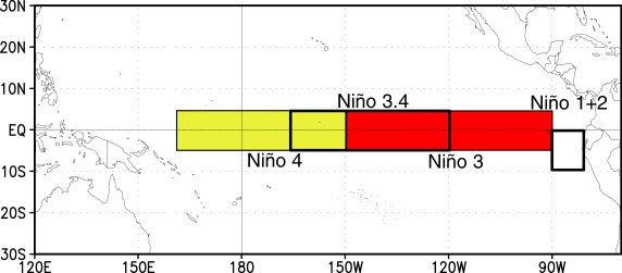
Niño 1+2: 0°–10°S, 90°W–80°W
Niño 3: 5°N–5°S, 150°W–90°W
Niño 3.4 (ONI): 5°N–5°S, 170°W–120°W
Niño 4: 5°N–5°S, 160°E–150°W
Sources: A, B
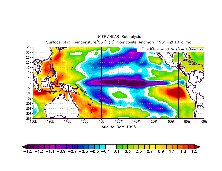
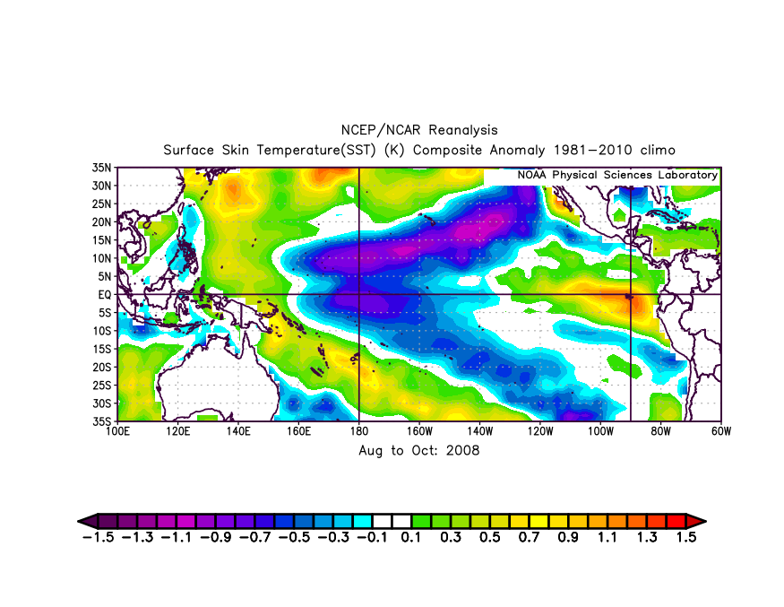
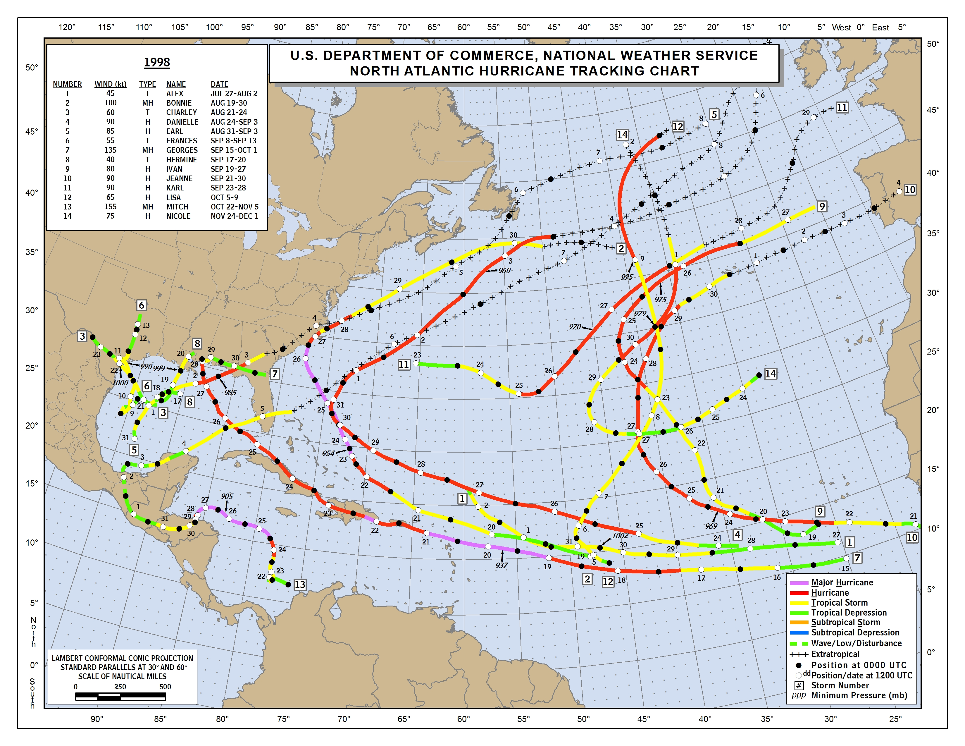
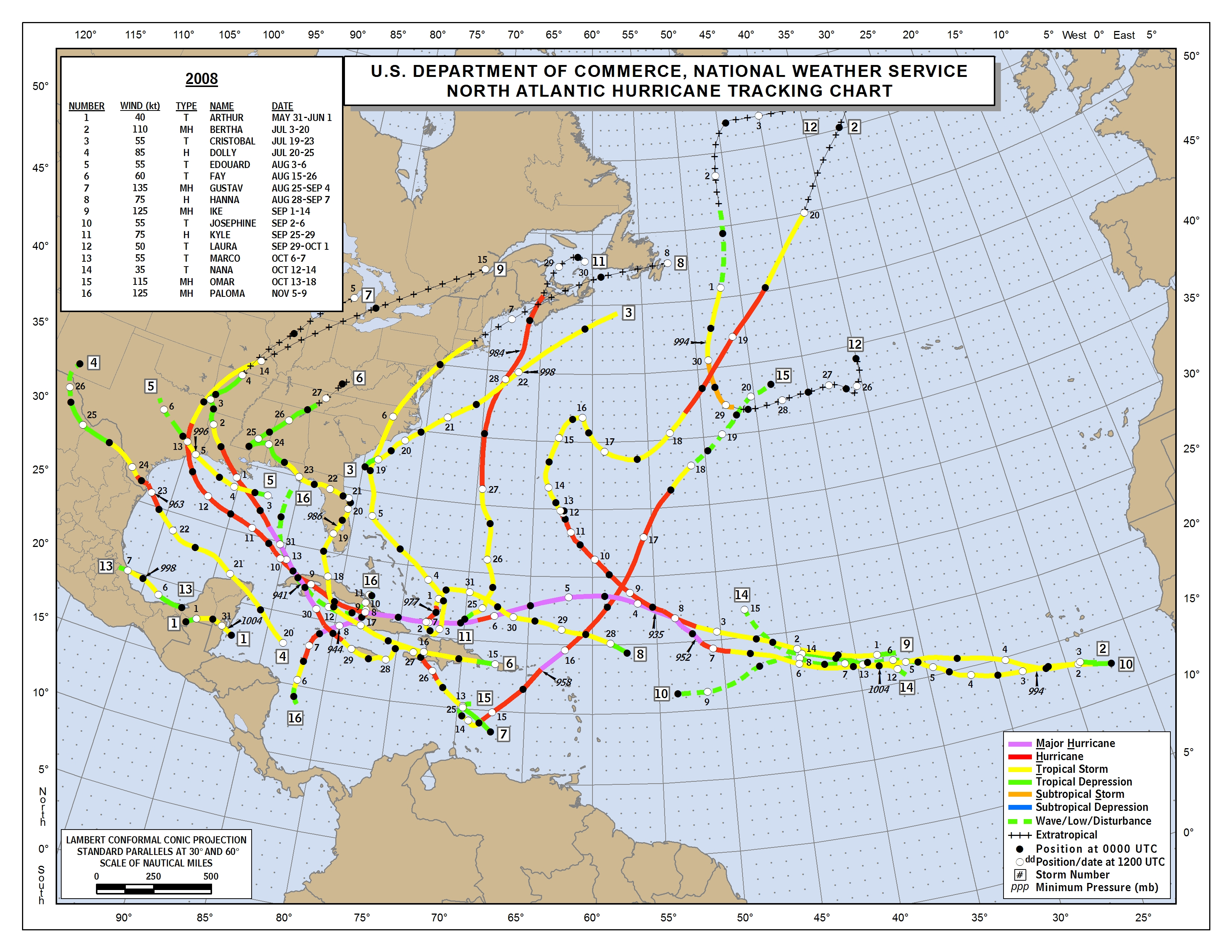
Based on these data, 1998 was actually a classical Niña, with its coldest SST anomalies in Niño 3.4, whereas 2008’s were clearly in Niño 4 (west-based). Clearly, the hyperactive 1998 season ended up with much higher seasonal ACE (~182) than the merely above-normal 2008 (~146) because its Niña was centred farther east, so the easternmost equatorial Pacific was cooler in Niño 1+2 than it was in 2008. So a west-based Niña on the CanSIPS actually would mean warmer SST closer to coastal South America, implying more convection over the EPAC TC-genesis region and thus increased VWS and sinking air over the Caribbean and western MDR. The CanSIPS solution thus would likely result in somewhat less intense Atlantic TC activity and lower ACE, even with the active African monsoon playing a role in negating the unfavourable ramifications somewhat. The CanSIPS solution would also imply a stronger TUTT over the deep tropics and also a Bermuda High that is farther northeast, suggesting a greater potential for storms forming in the (eastern) MDR to curve OTS, whereas a central- or east-based Niña would tend to weaken the TUTT and bring the Bermuda High’s axial extension farther west, increasing the risk of major landfalls in the Caribbean and on the CONUS. So the west-based CanSIPS run is actually relatively good news for the Atlantic vs. a classical or east-based Niña (or a west-based Niño).
Last edited by Shell Mound on Sun May 02, 2021 2:33 am, edited 1 time in total.
2 likes
CVW / MiamiensisWx / Shell Mound
The posts in this forum are NOT official forecasts and should not be used as such. They are just the opinion of the poster and may or may not be backed by sound meteorological data. They are NOT endorsed by any professional institution or STORM2K. For official information, please refer to products from the NHC and NWS.
-
Kingarabian

- S2K Supporter
- Posts: 16366
- Joined: Sat Aug 08, 2009 3:06 am
- Location: Honolulu, Hawaii
Re: 2021 Indicators: SST's / SAL / MSLP / Shear / Steering / Instability / Sat Images
While anything is possible this year, I'm not so sure Modoki La Nina is in the cards yet. It's not even present and other than what some of these models are showing, currently there's nothing to support such a development. The Nino 4 and Nino 3.4 regions are currently much warmer than the Nino 3 and Nino 1+2 regions. In Modoki La Nina's, Nino 4 and Nino 3.4 are much cooler than Nino 3 and Nino 1+2.
4 likes
RIP Kobe Bryant
-
Shell Mound
- Category 5
- Posts: 2432
- Age: 33
- Joined: Thu Sep 07, 2017 3:39 pm
- Location: St. Petersburg, FL → Scandinavia
Re: 2021 Indicators: SST's / SAL / MSLP / Shear / Steering / Instability / Sat Images
Kingarabian wrote:While anything is possible this year, I'm not so sure Modoki La Nina is in the cards yet. It's not even present and other than what some of these models are showing, currently there's nothing to support such a development. The Nino 4 and Nino 3.4 regions are currently much warmer than the Nino 3 and Nino 1+2 regions. In Modoki La Nina's, Nino 4 and Nino 3.4 are much cooler than Nino 3 and Nino 1+2.
The April ECMWF plume for Niño 1+2 seems to have verified considerably better than the March forecast, and it shows significant warming during MJJ, with a west-based Niña evolving by ASO. The CanSIPS shows this general evolution as well, likely due to CCKW activity + active MJO + subsurface warming. So I think there is a good chance that the warm anomalies in Niño 4+3.4 will subside over the coming months, while westerly wind anomalies focused over the eastern Niño zones will result in considerable warming there, especially relative to the western zones. This will end up reinforcing the “Modoki”-type Niña signature, given MJO-modulated periods of enhanced trades will tend to concentrate near the IDL. This will, in my view, end up being at least somewhat detrimental to Atlantic TC activity, particularly ACE, and also result in a less conducive steering regime to landfalls. We shall see.
0 likes
CVW / MiamiensisWx / Shell Mound
The posts in this forum are NOT official forecasts and should not be used as such. They are just the opinion of the poster and may or may not be backed by sound meteorological data. They are NOT endorsed by any professional institution or STORM2K. For official information, please refer to products from the NHC and NWS.

Re: 2021 Indicators: SST's / SAL / MSLP / Shear / Steering / Instability / Sat Images
There doesn’t seem to be alot of evidence for La Niña, Modiki or actual La Niña for this season just as much there not being much evidence for a warm ENSO.
I don’t care how much the SUBsurface East ENSO regions warm, it means nothing for this year if the actual surface doesn’t sufficiently warm for this season and I don’t see that happening for 2021.
Even Cool Neutral ENSO technically means a slightly more active EPAC season than what we saw last year and 2010 and therefor a not-as-much favorable as 2020 and 2005 Caribbean year, ( hence the slightly drier than average moisture models over the Caribbean) but I’d be fooling myself and everybody else into thinking that will impact the overall potential hyperactivity in the ATL for 2021 that much.
0 likes
-
Category5Kaiju
- Category 5
- Posts: 4335
- Joined: Thu Dec 24, 2020 12:45 pm
- Location: Seattle during the summer, Phoenix during the winter
Re: 2021 Indicators: SST's / SAL / MSLP / Shear / Steering / Instability / Sat Images
Many of these models (CanSIPS especially) are predicting a wetter than average Bahamas and Florida
0 likes
Unless explicitly stated, all information in my posts is based on my own opinions and observations. Tropical storms and hurricanes can be extremely dangerous. Refer to an accredited weather research agency or meteorologist if you need to make serious decisions regarding an approaching storm.
Who is online
Users browsing this forum: cycloneye and 228 guests