Texas Spring 2021
Moderator: S2k Moderators
Forum rules

The posts in this forum are NOT official forecast and should not be used as such. They are just the opinion of the poster and may or may not be backed by sound meteorological data. They are NOT endorsed by any professional institution or STORM2K.
-
rwfromkansas
- Category 5

- Posts: 3026
- Joined: Sat Aug 27, 2005 12:47 am
- Location: North Fort Worth
Re: Texas Spring 2021
The front dryline doesn’t appear truly stationary but has slowed a lot. I think all of DFW is at risk.
0 likes

Re: Texas Spring 2021
Tornado Watch 133< Previous WW Public|Counties|Probabilities|Aviation|Warnings|Initial RADAR
HazardTornadoesEF2+ TornadoesLikelihoodModerateModerateSevere Wind65 kt+ WindHighModerateSevere Hail2"+ HailModerateModerate
Note: The expiration time in the watch graphic is amended if the watch is replaced, cancelled or extended.
Note: Click for Watch Status Reports.
SEL3 URGENT - IMMEDIATE BROADCAST REQUESTED Tornado Watch Number 133 NWS Storm Prediction Center Norman OK 350 PM CDT Mon May 3 2021 The NWS Storm Prediction Center has issued a * Tornado Watch for portions of Southeast Oklahoma North-central Texas * Effective this Monday afternoon and evening from 350 PM until 1100 PM CDT. * Primary threats include... A few tornadoes likely with a couple intense tornadoes possible Scattered damaging winds and isolated significant gusts to 80 mph likely Scattered large hail and isolated very large hail events to 3.5 inches in diameter likely SUMMARY...Intense supercells are expected to initiate along the dryline in north-central Texas and the surface front in southeast Oklahoma by about 6 PM CDT. Very large hail will be the primary initial threat, but tornadoes and significant severe winds will be possible as well. Supercells should grow upscale into one or more clusters with an increasing risk of damaging winds this evening. The tornado watch area is approximately along and 60 statute miles east and west of a line from 10 miles northeast of Muskogee OK to 40 miles southwest of Waco TX. For a complete depiction of the watch see the associated watch outline update (WOUS64 KWNS WOU3). PRECAUTIONARY/PREPAREDNESS ACTIONS... REMEMBER...A Tornado Watch means conditions are favorable for tornadoes and severe thunderstorms in and close to the watch area. Persons in these areas should be on the lookout for threatening weather conditions and listen for later statements and possible warnings. &&
1 likes
-
bubba hotep

- S2K Supporter

- Posts: 6013
- Joined: Wed Dec 28, 2016 1:00 am
- Location: Collin County Texas

-
cheezyWXguy

- Category 5
- Posts: 6282
- Joined: Mon Feb 13, 2006 12:29 am
- Location: Dallas, TX
Re: Texas Spring 2021
EnnisTx wrote:Small returns popping up on radar out West.
Already getting stronger. This is like 2 hours ahead of the HRRR
0 likes
-
bubba hotep
- S2K Supporter
- Posts: 6013
- Joined: Wed Dec 28, 2016 1:00 am
- Location: Collin County Texas
Re: Texas Spring 2021
These first attempts might not take hold depending on if they can ger surface based as they push off that boundary but the dryline/front is clearly evident on radar..
0 likes
Winter time post are almost exclusively focused on the DFW area.
-
bubba hotep
- S2K Supporter
- Posts: 6013
- Joined: Wed Dec 28, 2016 1:00 am
- Location: Collin County Texas
Re: Texas Spring 2021
bubba hotep wrote:These first attempts might not take hold depending on if they can ger surface based as they push off that boundary but the dryline/front is clearly evident on radar..
Nope, these are the real deal.
3 likes
Winter time post are almost exclusively focused on the DFW area.


-
rwfromkansas
- Category 5
- Posts: 3026
- Joined: Sat Aug 27, 2005 12:47 am
- Location: North Fort Worth
-
bubba hotep
- S2K Supporter
- Posts: 6013
- Joined: Wed Dec 28, 2016 1:00 am
- Location: Collin County Texas

-
HockeyTx82
- S2K Supporter
- Posts: 2787
- Joined: Tue Oct 27, 2009 11:17 am
- Location: Ponder, TX
Re: Texas Spring 2021
I guess the line forming is a good thing...... less Tornado more smaller hail and wind?
0 likes
Don't hold me accountable for anything I post on this forum. Leave the real forecasting up to the professionals.
Location: Ponder, TX (all observation posts are this location unless otherwise noted)
Location: Ponder, TX (all observation posts are this location unless otherwise noted)

Re: Texas Spring 2021
HockeyTx82 wrote:I guess the line forming is a good thing...... less Tornado more smaller hail and wind?
Yeah the quicker they line up the more likely it shifts to some hail and high wind threat. The southernmost end likely has more tornadic threat.
0 likes
The above post and any post by Ntxw is NOT an official forecast and should not be used as such. It is just the opinion of the poster and may or may not be backed by sound meteorological data. It is NOT endorsed by any professional institution including Storm2k. For official information, please refer to NWS products.
Help support Storm2K!
-
cheezyWXguy
- Category 5
- Posts: 6282
- Joined: Mon Feb 13, 2006 12:29 am
- Location: Dallas, TX
Re: Texas Spring 2021
Ntxw wrote:HockeyTx82 wrote:I guess the line forming is a good thing...... less Tornado more smaller hail and wind?
Yeah the quicker they line up the more likely it shifts to some hail and high wind threat. The southernmost end likely has more tornadic threat.
Agreed. I have a bad feeling about that storm near granbury if it doesn’t get washed out by anything to the south
0 likes
Re: Texas Spring 2021
Ntxw wrote:HockeyTx82 wrote:I guess the line forming is a good thing...... less Tornado more smaller hail and wind?
Yeah the quicker they line up the more likely it shifts to some hail and high wind threat. The southernmost end likely has more tornadic threat.
The storm headed towards Tarrant County looks like the best bet for become tornadic.
0 likes
-
ElectricStorm

- Category 5
- Posts: 5141
- Age: 25
- Joined: Tue Aug 13, 2019 11:23 pm
- Location: Norman, OK
Re: Texas Spring 2021
cheezyWXguy wrote:Ntxw wrote:HockeyTx82 wrote:I guess the line forming is a good thing...... less Tornado more smaller hail and wind?
Yeah the quicker they line up the more likely it shifts to some hail and high wind threat. The southernmost end likely has more tornadic threat.
Agreed. I have a bad feeling about that storm near granbury if it doesn’t get washed out by anything to the south
Good call. It's confirmed now
0 likes
B.S Meteorology, University of Oklahoma '25
Please refer to the NHC, NWS, or SPC for official information.
Please refer to the NHC, NWS, or SPC for official information.
-
Texas Snowman

- Storm2k Moderator

- Posts: 6197
- Joined: Fri Jan 25, 2008 11:29 am
- Location: Denison, Texas
Re: Texas Spring 2021
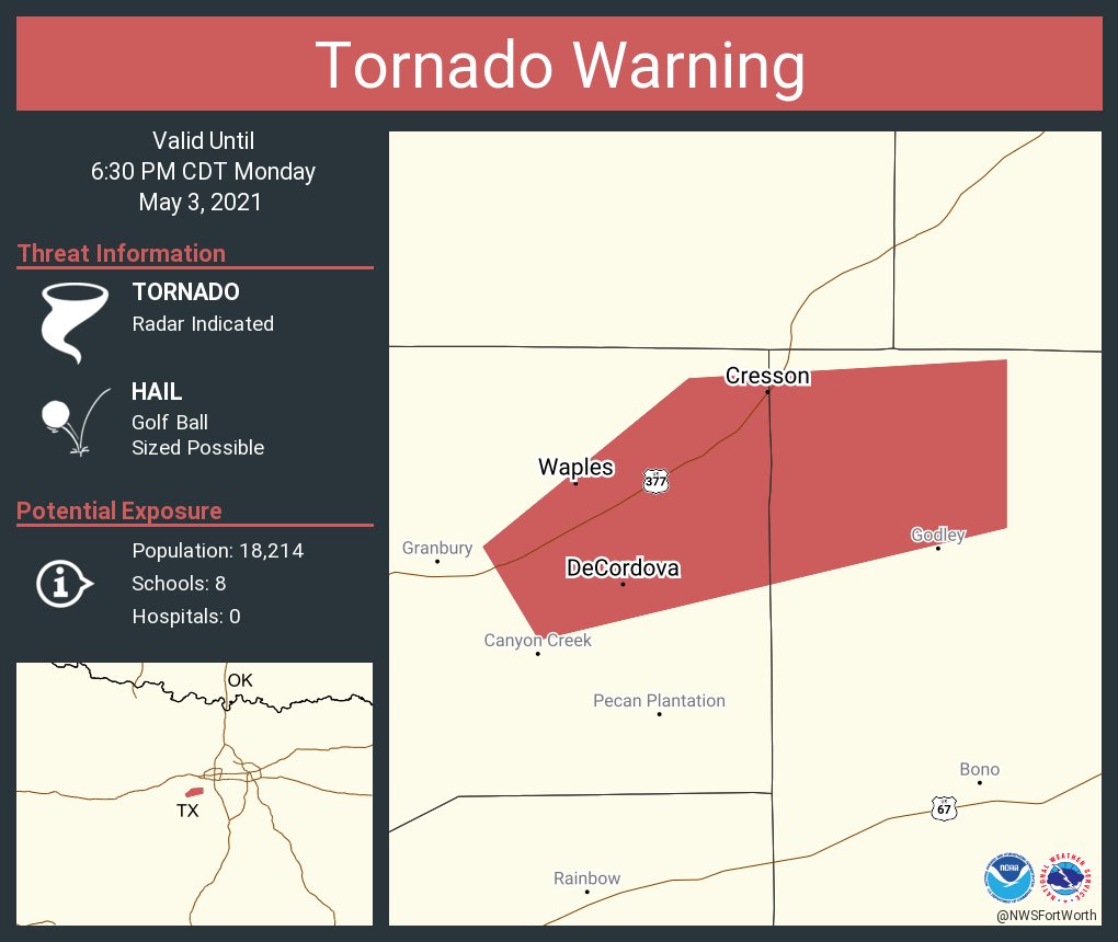
462
WFUS54 KFWD 032302
TORFWD
TXC221-251-032330-
/O.NEW.KFWD.TO.W.0009.210503T2302Z-210503T2330Z/
BULLETIN - EAS ACTIVATION REQUESTED
Tornado Warning
National Weather Service Fort Worth TX
602 PM CDT Mon May 3 2021
The National Weather Service in Fort Worth has issued a
* Tornado Warning for...
Northwestern Johnson County in north central Texas...
Northeastern Hood County in north central Texas...
* Until 630 PM CDT.
* At 601 PM CDT, trained spotters have reported a tornado near
Granbury, moving east at 10 mph.
HAZARD...Damaging tornado and golf ball size hail.
SOURCE...Weather spotters confirmed tornado.
IMPACT...Flying debris will be dangerous to those caught without
shelter. Mobile homes will be damaged or destroyed.
Damage to roofs, windows, and vehicles will occur. Tree
damage is likely.
* The tornado will be near...
Godley around 630 PM CDT.
PRECAUTIONARY/PREPAREDNESS ACTIONS...
To repeat, a tornado is on the ground. TAKE COVER NOW! Move to an
interior room on the lowest floor of a sturdy building. Avoid
windows. If you are outdoors, in a mobile home, or in a vehicle, move
to the closest substantial shelter and protect yourself from flying
debris.
&&
LAT...LON 3245 9779 3255 9767 3255 9749 3246 9749
3238 9775
TIME...MOT...LOC 2301Z 248DEG 10KT 3244 9772
TORNADO...OBSERVED
HAIL...1.75IN
$$
--
0 likes
The above post and any post by Texas Snowman is NOT an official forecast and should not be used as such. It is just the opinion of the poster and may or may not be backed by sound meteorological data. It is NOT endorsed by any professional institution including storm2k.org. For official information, please refer to NWS products.
Re: Texas Spring 2021
There's a good hook on the storm passing SW Denton county near Justin. This one may get a tor warning soon if one isn't already imminent or on the ground.
0 likes
The above post and any post by Ntxw is NOT an official forecast and should not be used as such. It is just the opinion of the poster and may or may not be backed by sound meteorological data. It is NOT endorsed by any professional institution including Storm2k. For official information, please refer to NWS products.
Help support Storm2K!
Help support Storm2K!
-
bubba hotep
- S2K Supporter
- Posts: 6013
- Joined: Wed Dec 28, 2016 1:00 am
- Location: Collin County Texas
-
bubba hotep
- S2K Supporter
- Posts: 6013
- Joined: Wed Dec 28, 2016 1:00 am
- Location: Collin County Texas
Re: Texas Spring 2021
It looked like things were going to quickly line out but now it's looking like we might be getting 3 dominate supercells or clusters. That will be problematic if they don't trend back towards a line here soon.
1 likes
Winter time post are almost exclusively focused on the DFW area.
-
cheezyWXguy
- Category 5
- Posts: 6282
- Joined: Mon Feb 13, 2006 12:29 am
- Location: Dallas, TX
Re: Texas Spring 2021
Weather Dude wrote:cheezyWXguy wrote:Ntxw wrote:
Yeah the quicker they line up the more likely it shifts to some hail and high wind threat. The southernmost end likely has more tornadic threat.
Agreed. I have a bad feeling about that storm near granbury if it doesn’t get washed out by anything to the south
Good call. It's confirmed now
Friend out in granbury actually saw it. Sounds like it didn’t last long though.
0 likes
Return to “USA & Caribbean Weather”
Who is online
Users browsing this forum: AnnularCane, MHTX5 and 109 guests