2021 Indicators: SST's / SAL / MSLP / Shear / Steering / Instability / Sat Images

This is the general tropical discussion area. Anyone can take their shot at predicting a storms path.

Moderator: S2k Moderators

Forum rules

The posts in this forum are NOT official forecasts and should not be used as such. They are just the opinion of the poster and may or may not be backed by sound meteorological data. They are NOT endorsed by any professional institution or STORM2K. For official information, please refer to products from the National Hurricane Center and National Weather Service.

Help Support Storm2K
Message
Author
User avatar
DorkyMcDorkface
Category 3
Category 3
Posts: 888
Age: 27
Joined: Mon Sep 30, 2019 1:32 pm
Location: Mid-Atlantic

Re: 2021 Indicators: SST's / SAL / MSLP / Shear / Steering / Instability / Sat Images

#361 Postby DorkyMcDorkface » Fri May 07, 2021 6:11 pm


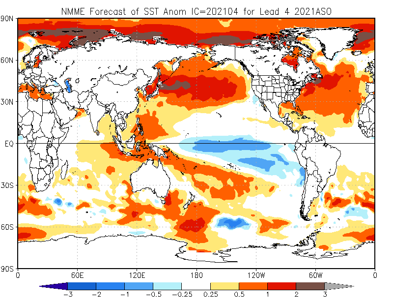
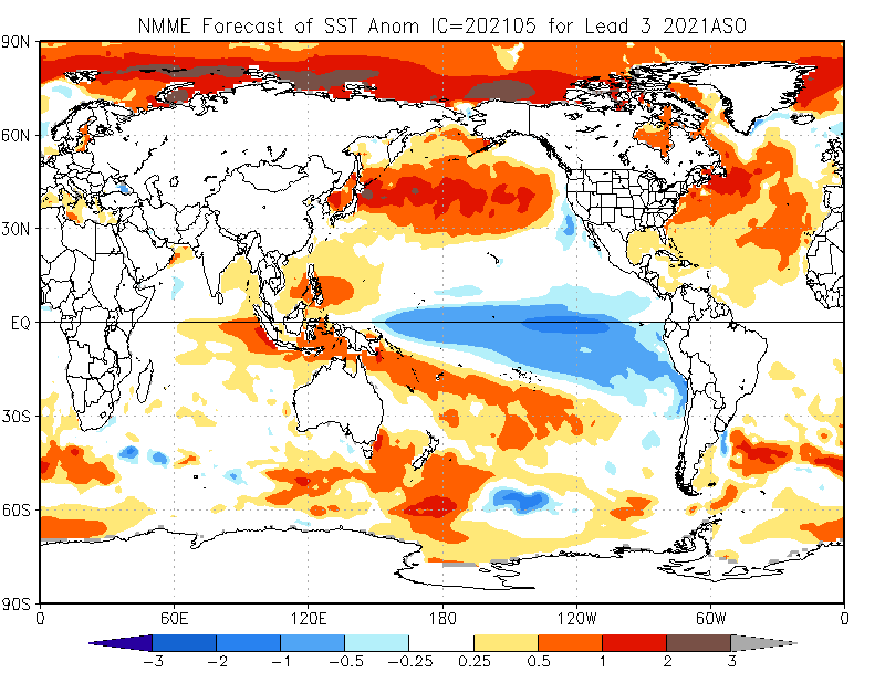
Little interesting that the PDO and PMM look more negative than last year. Would be a plus for the Atlantic should it verify as convection over the Eastern/Central Pacific likely wouldn't be as enhanced, thus lessening shear. Suppose that may be one thing this year may have over last year (although granted it really didn't make much of a difference last season as the Niña proved to be suppressive enough in the EPAC in its own right).
1 likes   
Please note the thougths expressed by this account are solely those of the user and are from a hobbyist perspective. For more comprehensive analysis, consult an actual professional meteorologist or meteorology agency.


Floyd 1999 | Isabel 2003 | Hanna 2008 | Irene 2011 | Sandy 2012 | Isaias 2020

Shell Mound
Category 5
Category 5
Posts: 2434
Age: 32
Joined: Thu Sep 07, 2017 3:39 pm
Location: St. Petersburg, FL → Scandinavia

Re: 2021 Indicators: SST's / SAL / MSLP / Shear / Steering / Instability / Sat Images

#362 Postby Shell Mound » Sat May 08, 2021 5:21 am

Image
Image
Image

The latest NMME for ASO 2021 is almost a perfect match relative to the years that featured major-hurricane landfalls on metropolitan South Florida. Note the below-average precipitation anomalies over the northwestern Caribbean, the western two-thirds of the Gulf, and the Great Plains region (due to heat ridging). Bermuda is also drier than normal due to a strong, west-based Bermuda High, as is the Upper Midwest (Great Lakes region). The NMME is clearly indicating a kind of “ridge-bridge” similar to that in the years that featured MH strikes on South FL. This is clearly different from the pattern projected for ASO 2020, but matches the ESRL composite for years with MH impacts on South FL.
0 likes   
CVW / MiamiensisWx / Shell Mound
The posts in this forum are NOT official forecasts and should not be used as such. They are just the opinion of the poster and may or may not be backed by sound meteorological data. They are NOT endorsed by any professional institution or STORM2K. For official information, please refer to products from the NHC and NWS.

User avatar
SFLcane
S2K Supporter
S2K Supporter
Posts: 10163
Age: 47
Joined: Sat Jun 05, 2010 1:44 pm
Location: Lake Worth Florida

Re: 2021 Indicators: SST's / SAL / MSLP / Shear / Steering / Instability / Sat Images

#363 Postby SFLcane » Sat May 08, 2021 9:07 am

Shell Mound wrote:https://www.cpc.ncep.noaa.gov/products/NMME/archive/2020050800/current/images/NMME_ensemble_prate_us_season3.png
https://www.cpc.ncep.noaa.gov/products/NMME/current/images/NMME_ensemble_prate_us_season3.png
https://i.postimg.cc/g2Pswm86/FLprecipitation-1.png

The latest NMME for ASO 2021 is almost a perfect match relative to the years that featured major-hurricane landfalls on metropolitan South Florida. Note the below-average precipitation anomalies over the northwestern Caribbean, the western two-thirds of the Gulf, and the Great Plains region (due to heat ridging). Bermuda is also drier than normal due to a strong, west-based Bermuda High, as is the Upper Midwest (Great Lakes region). The NMME is clearly indicating a kind of “ridge-bridge” similar to that in the years that featured MH strikes on South FL. This is clearly different from the pattern projected for ASO 2020, but matches the ESRL composite for years with MH impacts on South FL.


Great post but remember 2020 was pretty wet over Florida on NMME. Also magnitude of wetness looks quite small in 2021
0 likes   

User avatar
Category5Kaiju
Category 5
Category 5
Posts: 4096
Joined: Thu Dec 24, 2020 12:45 pm
Location: Seattle

Re: 2021 Indicators: SST's / SAL / MSLP / Shear / Steering / Instability / Sat Images

#364 Postby Category5Kaiju » Sat May 08, 2021 9:48 am

SFLcane wrote:
Shell Mound wrote:https://www.cpc.ncep.noaa.gov/products/NMME/archive/2020050800/current/images/NMME_ensemble_prate_us_season3.png
https://www.cpc.ncep.noaa.gov/products/NMME/current/images/NMME_ensemble_prate_us_season3.png
https://i.postimg.cc/g2Pswm86/FLprecipitation-1.png

The latest NMME for ASO 2021 is almost a perfect match relative to the years that featured major-hurricane landfalls on metropolitan South Florida. Note the below-average precipitation anomalies over the northwestern Caribbean, the western two-thirds of the Gulf, and the Great Plains region (due to heat ridging). Bermuda is also drier than normal due to a strong, west-based Bermuda High, as is the Upper Midwest (Great Lakes region). The NMME is clearly indicating a kind of “ridge-bridge” similar to that in the years that featured MH strikes on South FL. This is clearly different from the pattern projected for ASO 2020, but matches the ESRL composite for years with MH impacts on South FL.


Great post but remember 2020 was pretty wet over Florida on NMME. Also magnitude of wetness looks quite small in 2021


If I recall correctly last year was way wetter over the Western Gulf than Florida, at least the precip prediction maps frequently displayed that
0 likes   
Unless explicitly stated, all info in my posts is based on my own opinions and observations. Tropical storms and hurricanes can be extremely dangerous. Do not think you can beat Mother Nature. Refer to an accredited weather research agency or meteorologist if you need to make serious decisions regarding an approaching storm.

Shell Mound
Category 5
Category 5
Posts: 2434
Age: 32
Joined: Thu Sep 07, 2017 3:39 pm
Location: St. Petersburg, FL → Scandinavia

Re: 2021 Indicators: SST's / SAL / MSLP / Shear / Steering / Instability / Sat Images

#365 Postby Shell Mound » Sat May 08, 2021 10:23 am

Category5Kaiju wrote:
SFLcane wrote:
Shell Mound wrote:https://www.cpc.ncep.noaa.gov/products/NMME/archive/2020050800/current/images/NMME_ensemble_prate_us_season3.png
https://www.cpc.ncep.noaa.gov/products/NMME/current/images/NMME_ensemble_prate_us_season3.png
https://i.postimg.cc/g2Pswm86/FLprecipitation-1.png

The latest NMME for ASO 2021 is almost a perfect match relative to the years that featured major-hurricane landfalls on metropolitan South Florida. Note the below-average precipitation anomalies over the northwestern Caribbean, the western two-thirds of the Gulf, and the Great Plains region (due to heat ridging). Bermuda is also drier than normal due to a strong, west-based Bermuda High, as is the Upper Midwest (Great Lakes region). The NMME is clearly indicating a kind of “ridge-bridge” similar to that in the years that featured MH strikes on South FL. This is clearly different from the pattern projected for ASO 2020, but matches the ESRL composite for years with MH impacts on South FL.

Great post but remember 2020 was pretty wet over Florida on NMME. Also magnitude of wetness looks quite small in 2021

If I recall correctly last year was way wetter over the Western Gulf than Florida, at least the precip prediction maps frequently displayed that

Compared to April’s, May’s NMME is notably wetter over the Caribbean and the southwestern North Atlantic, including the Greater Antilles and the Bahamas:
Image
Image

Also, as mentioned previously, the precipitation pattern on May’s run closely resembles that of years with major hits in South FL (note the dry GoM):
Image

Additionally, note that May’s NMME has trended toward more of a +TNA vs. April’s run, despite overall SST being cooler (yet note the cooler NW Atlantic):
Image
Image

Note the trend, however subtle, toward an +AMO-aligned SST configuration over the northwestern North Atlantic, that is, the subtropics.
1 likes   
CVW / MiamiensisWx / Shell Mound
The posts in this forum are NOT official forecasts and should not be used as such. They are just the opinion of the poster and may or may not be backed by sound meteorological data. They are NOT endorsed by any professional institution or STORM2K. For official information, please refer to products from the NHC and NWS.

User avatar
SFLcane
S2K Supporter
S2K Supporter
Posts: 10163
Age: 47
Joined: Sat Jun 05, 2010 1:44 pm
Location: Lake Worth Florida

Re: 2021 Indicators: SST's / SAL / MSLP / Shear / Steering / Instability / Sat Images

#366 Postby SFLcane » Sat May 08, 2021 12:15 pm

0 likes   

Shell Mound
Category 5
Category 5
Posts: 2434
Age: 32
Joined: Thu Sep 07, 2017 3:39 pm
Location: St. Petersburg, FL → Scandinavia

Re: 2021 Indicators: SST's / SAL / MSLP / Shear / Steering / Instability / Sat Images

#367 Postby Shell Mound » Sat May 08, 2021 12:58 pm

1 likes   
CVW / MiamiensisWx / Shell Mound
The posts in this forum are NOT official forecasts and should not be used as such. They are just the opinion of the poster and may or may not be backed by sound meteorological data. They are NOT endorsed by any professional institution or STORM2K. For official information, please refer to products from the NHC and NWS.

User avatar
Kingarabian
S2K Supporter
S2K Supporter
Posts: 15980
Joined: Sat Aug 08, 2009 3:06 am
Location: Honolulu, Hawaii

Re: 2021 Indicators: SST's / SAL / MSLP / Shear / Steering / Instability / Sat Images

#368 Postby Kingarabian » Sat May 08, 2021 3:13 pm

The recent IMME forecast should be used with some caution. One member has a super La Nina which is very unlikely this year, and as a result has the skewed the forecast.
 https://twitter.com/webberweather/status/1390762706408337408


1 likes   
RIP Kobe Bryant

User avatar
Iceresistance
Category 5
Category 5
Posts: 9288
Age: 21
Joined: Sat Oct 10, 2020 9:45 am
Location: Tecumseh, OK/Norman, OK

Re: 2021 Indicators: SST's / SAL / MSLP / Shear / Steering / Instability / Sat Images

#369 Postby Iceresistance » Sat May 08, 2021 3:32 pm

Kingarabian wrote:The recent IMME forecast should be used with some caution. One member has a super La Nina which is very unlikely this year, and as a result has the skewed the forecast.
https://twitter.com/webberweather/status/1390762706408337408


When was the last time that a Super La Nina existed?
0 likes   
Bill 2015 & Beta 2020

Winter 2020-2021 :cold:

All observations are in Tecumseh, OK unless otherwise noted.

Winter posts are focused mainly for Oklahoma & Texas.

Take any of my forecasts with a grain of salt, refer to the NWS, SPC, and NHC for official information

Never say Never with weather! Because ANYTHING is possible!

User avatar
Category5Kaiju
Category 5
Category 5
Posts: 4096
Joined: Thu Dec 24, 2020 12:45 pm
Location: Seattle

Re: 2021 Indicators: SST's / SAL / MSLP / Shear / Steering / Instability / Sat Images

#370 Postby Category5Kaiju » Sat May 08, 2021 3:47 pm

Iceresistance wrote:
Kingarabian wrote:The recent IMME forecast should be used with some caution. One member has a super La Nina which is very unlikely this year, and as a result has the skewed the forecast.
https://twitter.com/webberweather/status/1390762706408337408


When was the last time that a Super La Nina existed?


2010 I believe. 2007 was also a quite potent La Nina, although if you are wondering the last time we had a La Nina that lasted for more than 2 years was in 1998, going from that year to nearly 2001.
1 likes   
Unless explicitly stated, all info in my posts is based on my own opinions and observations. Tropical storms and hurricanes can be extremely dangerous. Do not think you can beat Mother Nature. Refer to an accredited weather research agency or meteorologist if you need to make serious decisions regarding an approaching storm.

User avatar
Iceresistance
Category 5
Category 5
Posts: 9288
Age: 21
Joined: Sat Oct 10, 2020 9:45 am
Location: Tecumseh, OK/Norman, OK

Re: 2021 Indicators: SST's / SAL / MSLP / Shear / Steering / Instability / Sat Images

#371 Postby Iceresistance » Sat May 08, 2021 3:54 pm

Category5Kaiju wrote:
Iceresistance wrote:
Kingarabian wrote:The recent IMME forecast should be used with some caution. One member has a super La Nina which is very unlikely this year, and as a result has the skewed the forecast.
https://twitter.com/webberweather/status/1390762706408337408


When was the last time that a Super La Nina existed?


2010 I believe. 2007 was also a quite potent La Nina, although if you are wondering the last time we had a La Nina that lasted for more than 2 years was in 1998, going from that year to nearly 2001.

Yes, the 2010 La Nina is the strongest recorded, but, I've noticed a pattern. :darrow:

Every Decade or so, there is a Double La Nina (1998-1999 & 1999-2000) & (2010-2011 & 2011-2012)

Could this be the next Double La Nina?
2 likes   
Bill 2015 & Beta 2020

Winter 2020-2021 :cold:

All observations are in Tecumseh, OK unless otherwise noted.

Winter posts are focused mainly for Oklahoma & Texas.

Take any of my forecasts with a grain of salt, refer to the NWS, SPC, and NHC for official information

Never say Never with weather! Because ANYTHING is possible!

User avatar
Kingarabian
S2K Supporter
S2K Supporter
Posts: 15980
Joined: Sat Aug 08, 2009 3:06 am
Location: Honolulu, Hawaii

Re: 2021 Indicators: SST's / SAL / MSLP / Shear / Steering / Instability / Sat Images

#372 Postby Kingarabian » Sat May 08, 2021 3:58 pm

Iceresistance wrote:
Category5Kaiju wrote:
Iceresistance wrote:
When was the last time that a Super La Nina existed?


2010 I believe. 2007 was also a quite potent La Nina, although if you are wondering the last time we had a La Nina that lasted for more than 2 years was in 1998, going from that year to nearly 2001.

Yes, the 2010 La Nina is the strongest recorded, but, I've noticed a pattern. :darrow:

Every Decade or so, there is a Double La Nina (1998-1999 & 1999-2000) & (2010-2011 & 2011-2012)

Could this be the next Double La Nina?

I think it's possible again this year. 2016-2017, albeit weak. was also a double dip La Nina
0 likes   
RIP Kobe Bryant

User avatar
Category5Kaiju
Category 5
Category 5
Posts: 4096
Joined: Thu Dec 24, 2020 12:45 pm
Location: Seattle

Re: 2021 Indicators: SST's / SAL / MSLP / Shear / Steering / Instability / Sat Images

#373 Postby Category5Kaiju » Sat May 08, 2021 4:50 pm

What I personally am actually more interested to see is when the next true El Nino would occur; the 2018-2019 one was, while almost a moderate El Nino at its peak at roughly 0.9 C if I am not mistaken, it unexpectedly died in the summer of 2019, and so this makes 2015 the last actual El Nino year. I would think next year is somewhat likely to feature an El Nino, although I (as I have said before) am not sure if future WAMs would actually impact the strength and dynamics of these Ninos assuming recent patterns hold.
0 likes   
Unless explicitly stated, all info in my posts is based on my own opinions and observations. Tropical storms and hurricanes can be extremely dangerous. Do not think you can beat Mother Nature. Refer to an accredited weather research agency or meteorologist if you need to make serious decisions regarding an approaching storm.

User avatar
NDG
S2K Supporter
S2K Supporter
Posts: 15446
Joined: Sun Jul 09, 2006 10:14 pm
Location: Orlando, FL

Re: 2021 Indicators: SST's / SAL / MSLP / Shear / Steering / Instability / Sat Images

#374 Postby NDG » Sun May 09, 2021 6:42 am

We usually start seeing signs of what the over all pattern will be like during the hurricane season later in May and June.
If the NAO stays mostly negative like it has so far this Spring I would expect a lot of OTS storms east of Bermuda, the reason why the NMME shows a drier eastern Caribbean.
0 likes   

Shell Mound
Category 5
Category 5
Posts: 2434
Age: 32
Joined: Thu Sep 07, 2017 3:39 pm
Location: St. Petersburg, FL → Scandinavia

Re: 2021 Indicators: SST's / SAL / MSLP / Shear / Steering / Instability / Sat Images

#375 Postby Shell Mound » Mon May 10, 2021 4:34 am

Image
Image
Image
0 likes   
CVW / MiamiensisWx / Shell Mound
The posts in this forum are NOT official forecasts and should not be used as such. They are just the opinion of the poster and may or may not be backed by sound meteorological data. They are NOT endorsed by any professional institution or STORM2K. For official information, please refer to products from the NHC and NWS.

User avatar
Steve
S2K Supporter
S2K Supporter
Posts: 9621
Joined: Sat Apr 05, 2003 11:41 pm
Location: Not a state-caster

Re: 2021 Indicators: SST's / SAL / MSLP / Shear / Steering / Instability / Sat Images

#376 Postby Steve » Mon May 10, 2021 11:33 am

NDG wrote:We usually start seeing signs of what the over all pattern will be like during the hurricane season later in May and June.
If the NAO stays mostly negative like it has so far this Spring I would expect a lot of OTS storms east of Bermuda, the reason why the NMME shows a drier eastern Caribbean.


I know weatherbell addressed the trough in the NEUS and NWAtl for May and said it would migrate with high pressure moving into that area during the heart of the hurricane season (thus their forecast for a lot of hits on the US again).

?
0 likes   

User avatar
cycloneye
Admin
Admin
Posts: 145299
Age: 68
Joined: Thu Oct 10, 2002 10:54 am
Location: San Juan, Puerto Rico

Re: 2021 Indicators: SST's / SAL / MSLP / Shear / Steering / Instability / Sat Images

#377 Postby cycloneye » Mon May 10, 2021 5:30 pm

Much cooler MDR in 2021 than in 2020 for this time of year. We will see how things evolve in the next 3 months.

Image

Image
0 likes   
Visit the Caribbean-Central America Weather Thread where you can find at first post web cams,radars
and observations from Caribbean basin members Click Here

User avatar
toad strangler
S2K Supporter
S2K Supporter
Posts: 4543
Joined: Sun Jul 28, 2013 3:09 pm
Location: Earth
Contact:

Re: 2021 Indicators: SST's / SAL / MSLP / Shear / Steering / Instability / Sat Images

#378 Postby toad strangler » Mon May 10, 2021 6:21 pm

cycloneye wrote:Much cooler MDR in 2021 than in 2020 for this time of year. We will see how things evolve in the next 3 months.


A cooler MDR IRT average could help waves and or pouches to meander further W than they should to terrorize those downstream.
0 likes   

User avatar
CyclonicFury
Category 5
Category 5
Posts: 2025
Age: 26
Joined: Sun Jul 02, 2017 12:32 pm
Location: NC
Contact:

Re: 2021 Indicators: SST's / SAL / MSLP / Shear / Steering / Instability / Sat Images

#379 Postby CyclonicFury » Mon May 10, 2021 6:51 pm

cycloneye wrote:Much cooler MDR in 2021 than in 2020 for this time of year. We will see how things evolve in the next 3 months.

https://i.imgur.com/EChooUp.png

https://i.imgur.com/iwnGPf1.png

That is the 7 day change, not the current SST anomaly, and the CDAS tends to run cooler than other datasets. Regardless, the MDR is cooler than 2020.
7 likes   
NCSU B.S. in Meteorology Class of 2021. Tropical weather blogger at http://www.cyclonicfury.com. My forecasts and thoughts are NOT official, for official forecasts please consult the National Hurricane Center.

Shell Mound
Category 5
Category 5
Posts: 2434
Age: 32
Joined: Thu Sep 07, 2017 3:39 pm
Location: St. Petersburg, FL → Scandinavia

Re: 2021 Indicators: SST's / SAL / MSLP / Shear / Steering / Instability / Sat Images

#380 Postby Shell Mound » Tue May 11, 2021 4:35 am

CyclonicFury wrote:
cycloneye wrote:Much cooler MDR in 2021 than in 2020 for this time of year. We will see how things evolve in the next 3 months.

https://i.imgur.com/EChooUp.png

https://i.imgur.com/iwnGPf1.png

That is the 7 day change, not the current SST anomaly, and the CDAS tends to run cooler than other datasets. Regardless, the MDR is cooler than 2020.

Enhanced low-level easterlies (trades) over most of the MDR have certainly been playing a key role over the past month. Interestingly, the NAO has been strongly negative, albeit west-based, during the same timeframe. Perhaps the expansion of Hadley cells due to climate change means that in the near future -NAO episodes will not correlate as strongly with a warmer MDR, due to the low-level westerlies shifting northward into the subtropics, to be supplanted by net easterlies underneath. Regardless, the SST configuration in the remote North Atlantic, particularly to the immediate south of Iceland, recalls that of a -AMO rather than +AMO, given abundant freshwater intrusion from Greenland vis-à-vis AGW feedback → freshening of the North Atlantic Deep Water (NADW) → weakening of the Atlantic meridional overturning circulation (AMOC).
Image
Image
Image
0 likes   
CVW / MiamiensisWx / Shell Mound
The posts in this forum are NOT official forecasts and should not be used as such. They are just the opinion of the poster and may or may not be backed by sound meteorological data. They are NOT endorsed by any professional institution or STORM2K. For official information, please refer to products from the NHC and NWS.


Return to “Talkin' Tropics”

Who is online

Users browsing this forum: No registered users and 21 guests