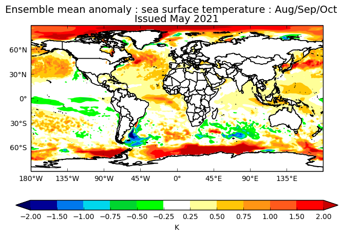
2021 Indicators: SST's / SAL / MSLP / Shear / Steering / Instability / Sat Images

This is the general tropical discussion area. Anyone can take their shot at predicting a storms path.

Moderator: S2k Moderators

Forum rules

The posts in this forum are NOT official forecasts and should not be used as such. They are just the opinion of the poster and may or may not be backed by sound meteorological data. They are NOT endorsed by any professional institution or STORM2K. For official information, please refer to products from the National Hurricane Center and National Weather Service.

Help Support Storm2K
Message
Author
User avatar
Category5Kaiju
Category 5
Category 5
Posts: 4096
Joined: Thu Dec 24, 2020 12:45 pm
Location: Seattle

Re: 2021 Indicators: SST's / SAL / MSLP / Shear / Steering / Instability / Sat Images

#381 Postby Category5Kaiju » Tue May 11, 2021 7:32 am

Shell Mound wrote:
CyclonicFury wrote:
cycloneye wrote:Much cooler MDR in 2021 than in 2020 for this time of year. We will see how things evolve in the next 3 months.

https://i.imgur.com/EChooUp.png

https://i.imgur.com/iwnGPf1.png

That is the 7 day change, not the current SST anomaly, and the CDAS tends to run cooler than other datasets. Regardless, the MDR is cooler than 2020.

Enhanced low-level easterlies (trades) over most of the MDR have certainly been playing a key role over the past month. Interestingly, the NAO has been strongly negative, albeit west-based, during the same timeframe. Perhaps the expansion of Hadley cells due to climate change means that in the near future -NAO episodes will not correlate as strongly with a warmer MDR, due to the low-level westerlies shifting northward into the subtropics, to be supplanted by net easterlies underneath. Regardless, the SST configuration in the remote North Atlantic, particularly to the immediate south of Iceland, recalls that of a -AMO rather than +AMO, given abundant freshwater intrusion from Greenland vis-à-vis AGW feedback → freshening of the North Atlantic Deep Water (NADW) → weakening of the Atlantic meridional overturning circulation (AMOC).
https://i.postimg.cc/50J6kRSY/2021-Uanom-1.gif
https://i.postimg.cc/RZ363f0F/2021-SST-1.gif
https://i.postimg.cc/CxN8pYdC/2021NAO.gif


So in terms of this season's predicted activity, does this have any major implications in one way or another?
0 likes   
Unless explicitly stated, all info in my posts is based on my own opinions and observations. Tropical storms and hurricanes can be extremely dangerous. Do not think you can beat Mother Nature. Refer to an accredited weather research agency or meteorologist if you need to make serious decisions regarding an approaching storm.

User avatar
cycloneye
Admin
Admin
Posts: 145299
Age: 68
Joined: Thu Oct 10, 2002 10:54 am
Location: San Juan, Puerto Rico

Re: 2021 Indicators: SST's / SAL / MSLP / Shear / Steering / Instability / Sat Images

#382 Postby cycloneye » Tue May 11, 2021 7:54 am

UKMET has cool neutral for ASO and has a wetter Caribbean that is different from other models.

 https://twitter.com/AndyHazelton/status/1392099824347095040


2 likes   
Visit the Caribbean-Central America Weather Thread where you can find at first post web cams,radars
and observations from Caribbean basin members Click Here

User avatar
SFLcane
S2K Supporter
S2K Supporter
Posts: 10163
Age: 47
Joined: Sat Jun 05, 2010 1:44 pm
Location: Lake Worth Florida

Re: 2021 Indicators: SST's / SAL / MSLP / Shear / Steering / Instability / Sat Images

#383 Postby SFLcane » Tue May 11, 2021 8:35 am

cycloneye wrote:UKMET has cool neutral for ASO and has a wetter Caribbean that is different from other models.

https://twitter.com/AndyHazelton/status/1392099824347095040


Much more active look then the Euro for sure because it warms the Atlantic. That’s the question mark I see
4 likes   

Shell Mound
Category 5
Category 5
Posts: 2434
Age: 32
Joined: Thu Sep 07, 2017 3:39 pm
Location: St. Petersburg, FL → Scandinavia

Re: 2021 Indicators: SST's / SAL / MSLP / Shear / Steering / Instability / Sat Images

#384 Postby Shell Mound » Tue May 11, 2021 11:00 am

SFLcane wrote:
cycloneye wrote:UKMET has cool neutral for ASO and has a wetter Caribbean that is different from other models.

https://twitter.com/AndyHazelton/status/1392099824347095040

Much more active look then the Euro for sure because it warms the Atlantic. That’s the question mark I see

Although the UKMET is envisioning a somewhat weaker African monsoon than in 2020, it is actually showing more precipitation over the Sahel and the MDR, along with a much drier EPAC, even though the IOD and ENSO are expected to be closer to neutral than Niña. Furthermore, notably, the latest forecast signifies a stronger +AMO than the previous outlook did in 2020. On the latest run the southern half of the Caribbean looks to be roughly as wet as in 2020. Given the drier conditions over the Greater Antilles, along with a warm Gulf of Guinea, this run is likely implying a more active CV season than in 2020, because the weaker African monsoon allows storms to consolidate earlier over a warmer MDR, rather than wait until farther west. The run also seems to imply a -NAO during peak season, hence many OTS tracks and a reduced risk to FL and/or the Eastern Seaboard, as in 2010. Note the absence of abnormally dry conditions over the Great Plains during ASO, hence less of a “ridge-bridge” and a weaker, more suppressed Bermuda High than in 2020. (Incidentally, 2010 also featured a very active MDR and a strong +AMO despite a warm Gulf of Guinea.)

Image
Image
Image
Image
Image
Image
0 likes   
CVW / MiamiensisWx / Shell Mound
The posts in this forum are NOT official forecasts and should not be used as such. They are just the opinion of the poster and may or may not be backed by sound meteorological data. They are NOT endorsed by any professional institution or STORM2K. For official information, please refer to products from the NHC and NWS.

User avatar
SFLcane
S2K Supporter
S2K Supporter
Posts: 10163
Age: 47
Joined: Sat Jun 05, 2010 1:44 pm
Location: Lake Worth Florida

Re: 2021 Indicators: SST's / SAL / MSLP / Shear / Steering / Instability / Sat Images

#385 Postby SFLcane » Tue May 11, 2021 11:11 am

Shell Mound wrote:
SFLcane wrote:
cycloneye wrote:UKMET has cool neutral for ASO and has a wetter Caribbean that is different from other models.

https://twitter.com/AndyHazelton/status/1392099824347095040

Much more active look then the Euro for sure because it warms the Atlantic. That’s the question mark I see

Although the UKMET is envisioning a somewhat weaker African monsoon than in 2020, it is actually showing more precipitation over the Sahel and the MDR, along with a much drier EPAC, even though the IOD and ENSO are expected to be closer to neutral than Niña. Furthermore, notably, the latest forecast signifies a stronger +AMO than the previous outlook did in 2020. On the latest run the southern half of the Caribbean looks to be roughly as wet as in 2020. Given the drier conditions over the Greater Antilles, along with a warm Gulf of Guinea, this run is likely implying a more active CV season than in 2020, because the weaker African monsoon allows storms to consolidate earlier over a warmer MDR, rather than wait until farther west. The run also seems to imply a -NAO during peak season, hence many OTS tracks and a reduced risk to FL and/or the Eastern Seaboard, as in 2010. Note the absence of abnormally dry conditions over the Great Plains during ASO, hence less of a “ridge-bridge” and a weaker, more suppressed Bermuda High than in 2020. (Incidentally, 2010 also featured a very active MDR and a strong +AMO despite a warm Gulf of Guinea.)

https://i.postimg.cc/7Pg06KWj/2020-UKMET-1.png
https://i.postimg.cc/Z5qdw45h/2021-UKMET-1.png
https://i.postimg.cc/g2Pswm86/FLprecipitation-1.png
https://i.postimg.cc/GhdYsk0t/2020-UKMET-2.png
https://i.postimg.cc/Qxm7gHsb/2021-UKMET-2.png


Florida looks wet on the UKMET. October could be driving a lot of that probably. Honestly this is all just clear cut speculation as we can’t even get a forecast right 3-5 days out yet along what will happen in 3 months. As far as i’am concerned everyone living in a coastal community in a hurricane zone is fair game and with no El Niño this year everyone should be ready.
9 likes   

User avatar
CyclonicFury
Category 5
Category 5
Posts: 2025
Age: 26
Joined: Sun Jul 02, 2017 12:32 pm
Location: NC
Contact:

Re: 2021 Indicators: SST's / SAL / MSLP / Shear / Steering / Instability / Sat Images

#386 Postby CyclonicFury » Tue May 11, 2021 11:20 am

Shell Mound wrote:
SFLcane wrote:
cycloneye wrote:UKMET has cool neutral for ASO and has a wetter Caribbean that is different from other models.

https://twitter.com/AndyHazelton/status/1392099824347095040

Much more active look then the Euro for sure because it warms the Atlantic. That’s the question mark I see

Although the UKMET is envisioning a somewhat weaker African monsoon than in 2020, it is actually showing more precipitation over the Sahel and the MDR, along with a much drier EPAC, even though the IOD and ENSO are expected to be closer to neutral than Niña. Furthermore, notably, the latest forecast signifies a stronger +AMO than the previous outlook did in 2020. On the latest run the southern half of the Caribbean looks to be roughly as wet as in 2020. Given the drier conditions over the Greater Antilles, along with a warm Gulf of Guinea, this run is likely implying a more active CV season than in 2020, because the weaker African monsoon allows storms to consolidate earlier over a warmer MDR, rather than wait until farther west. The run also seems to imply a -NAO during peak season, hence many OTS tracks and a reduced risk to FL and/or the Eastern Seaboard, as in 2010. Note the absence of abnormally dry conditions over the Great Plains during ASO, hence less of a “ridge-bridge” and a weaker, more suppressed Bermuda High than in 2020. (Incidentally, 2010 also featured a very active MDR and a strong +AMO despite a warm Gulf of Guinea.)

https://i.postimg.cc/7Pg06KWj/2020-UKMET-1.png
https://i.postimg.cc/Z5qdw45h/2021-UKMET-1.png
https://i.postimg.cc/g2Pswm86/FLprecipitation-1.png
https://i.postimg.cc/GhdYsk0t/2020-UKMET-2.png
https://i.postimg.cc/Qxm7gHsb/2021-UKMET-2.png
https://i.postimg.cc/50TtSQ2X/2010-ASOSST-1.png

It seems like you are always downplaying the risk to Florida. Of course it is possible if not likely South Florida will avoid a big hit again, but NOAA stresses every year in their preseason outlooks that you cannot predict which areas will be affected (or safe) months in advance.
14 likes   
NCSU B.S. in Meteorology Class of 2021. Tropical weather blogger at http://www.cyclonicfury.com. My forecasts and thoughts are NOT official, for official forecasts please consult the National Hurricane Center.

User avatar
Iceresistance
Category 5
Category 5
Posts: 9288
Age: 21
Joined: Sat Oct 10, 2020 9:45 am
Location: Tecumseh, OK/Norman, OK

Re: 2021 Indicators: SST's / SAL / MSLP / Shear / Steering / Instability / Sat Images

#387 Postby Iceresistance » Wed May 12, 2021 8:39 am

SST anomalies in the Atlantic, around 20ºN is where the dividing line is between above normal & below normal SSTs . . .
Image
1 likes   
Bill 2015 & Beta 2020

Winter 2020-2021 :cold:

All observations are in Tecumseh, OK unless otherwise noted.

Winter posts are focused mainly for Oklahoma & Texas.

Take any of my forecasts with a grain of salt, refer to the NWS, SPC, and NHC for official information

Never say Never with weather! Because ANYTHING is possible!

User avatar
SFLcane
S2K Supporter
S2K Supporter
Posts: 10163
Age: 47
Joined: Sat Jun 05, 2010 1:44 pm
Location: Lake Worth Florida

Re: 2021 Indicators: SST's / SAL / MSLP / Shear / Steering / Instability / Sat Images

#388 Postby SFLcane » Wed May 12, 2021 9:39 am

Iceresistance wrote:SST anomalies in the Atlantic, around 20ºN is where the dividing line is between above normal & below normal SSTs . . .
https://s3.gifyu.com/images/crw_sstamean_natl.png


What in the world? That has to be as unfavorable look as I have seen in a while. If this holds look for bunch development in the sub-tropics this season. A break for the mainland let’s hope.
0 likes   

User avatar
JetFuel_SE
Category 1
Category 1
Posts: 282
Age: 25
Joined: Thu Apr 30, 2020 3:57 pm

Re: 2021 Indicators: SST's / SAL / MSLP / Shear / Steering / Instability / Sat Images

#389 Postby JetFuel_SE » Wed May 12, 2021 9:45 am

SFLcane wrote:
Iceresistance wrote:SST anomalies in the Atlantic, around 20ºN is where the dividing line is between above normal & below normal SSTs . . .
https://s3.gifyu.com/images/crw_sstamean_natl.png


What in the world? That has to be as unfavorable look as I have seen in a while. If this holds look for bunch development in the sub-tropics this season. A break for the mainland let’s hope.

That is vs the global mean, which tends to look way less favorable than it actually is.
2 likes   

User avatar
HurricaneEnzo
Category 2
Category 2
Posts: 739
Joined: Wed Mar 14, 2018 12:18 pm
Location: Newport, NC (Hurricane Alley)

Re: 2021 Indicators: SST's / SAL / MSLP / Shear / Steering / Instability / Sat Images

#390 Postby HurricaneEnzo » Wed May 12, 2021 9:58 am

Still 3 weeks before the official start of the season and really the MDR doesn't get cranking til August. Yeah we occasionally get some storms sooner but still plenty of time for things to change. I did figure it would be a little warmer by now though. But as someone said the image above is global mean. The regular anomaly map is still cool but not quite as bad.
0 likes   
Bertha 96' - Fran 96' - Bonnie 98' - Dennis 99' - Floyd 99' - Isabel 03' - Alex 04' - Ophelia 05' - Irene 11' - Arthur 14' - Matthew 16' - Florence 18' - Dorian 19' - Isaias 20' (countless other tropical storms and Hurricane swipes)

I am not a Professional Met just an enthusiast. Get your weather forecasts from the Pros!

User avatar
Category5Kaiju
Category 5
Category 5
Posts: 4096
Joined: Thu Dec 24, 2020 12:45 pm
Location: Seattle

Re: 2021 Indicators: SST's / SAL / MSLP / Shear / Steering / Instability / Sat Images

#391 Postby Category5Kaiju » Wed May 12, 2021 10:06 am

 https://twitter.com/cyclonicwx/status/1392493369050419203


This warmth in the Atlantic Nino region as well as the warm Canary Current imho suggest that while the MDR may not look very favorable now, I personally think it will warm up in the coming months.
0 likes   
Unless explicitly stated, all info in my posts is based on my own opinions and observations. Tropical storms and hurricanes can be extremely dangerous. Do not think you can beat Mother Nature. Refer to an accredited weather research agency or meteorologist if you need to make serious decisions regarding an approaching storm.

User avatar
SFLcane
S2K Supporter
S2K Supporter
Posts: 10163
Age: 47
Joined: Sat Jun 05, 2010 1:44 pm
Location: Lake Worth Florida

Re: 2021 Indicators: SST's / SAL / MSLP / Shear / Steering / Instability / Sat Images

#392 Postby SFLcane » Wed May 12, 2021 10:08 am

HurricaneEnzo wrote:Still 3 weeks before the official start of the season and really the MDR doesn't get cranking til August. Yeah we occasionally get some storms sooner but still plenty of time for things to change. I did figure it would be a little warmer by now though. But as someone said the image above is global mean. The regular anomaly map is still cool but not quite as bad.


It’s clearly running way behind 2020 and most of the warmth is in the sub-tropics thus far. I’d venture to say it’s not a look of a very active season but we shall see lots can change. Reminds me a lot of 2019
3 likes   

User avatar
cycloneye
Admin
Admin
Posts: 145299
Age: 68
Joined: Thu Oct 10, 2002 10:54 am
Location: San Juan, Puerto Rico

Re: 2021 Indicators: SST's / SAL / MSLP / Shear / Steering / Instability / Sat Images

#393 Postby cycloneye » Wed May 12, 2021 10:54 am

Does anyone has a 2020 ssta graphic by this time to compare with 2021 at MDR?
0 likes   
Visit the Caribbean-Central America Weather Thread where you can find at first post web cams,radars
and observations from Caribbean basin members Click Here

OuterBanker
S2K Supporter
S2K Supporter
Posts: 1731
Joined: Wed Feb 26, 2003 10:53 am
Location: Nags Head, NC
Contact:

Re: 2021 Indicators: SST's / SAL / MSLP / Shear / Steering / Instability / Sat Images

#394 Postby OuterBanker » Wed May 12, 2021 11:33 am

Wow. Season over posts already!
10 likes   

User avatar
Category5Kaiju
Category 5
Category 5
Posts: 4096
Joined: Thu Dec 24, 2020 12:45 pm
Location: Seattle

Re: 2021 Indicators: SST's / SAL / MSLP / Shear / Steering / Instability / Sat Images

#395 Postby Category5Kaiju » Wed May 12, 2021 11:45 am

OuterBanker wrote:Wow. Season over posts already!


:lol: Yeah, then again in recent years (even years like 2018 and 2019) the MDR was quite cool in May but significantly warmed up in the summer. I am definitely in the mindset of just wait and see, because if current models hold and a cool neutral pattern or something like that emerges then I am confident that the MDR will warm up. This sst anomaly profile as of now definitely does not mean it will hold into August of course, and as a matter of fact if it does then that would certainly defy all of my expectations.
4 likes   
Unless explicitly stated, all info in my posts is based on my own opinions and observations. Tropical storms and hurricanes can be extremely dangerous. Do not think you can beat Mother Nature. Refer to an accredited weather research agency or meteorologist if you need to make serious decisions regarding an approaching storm.

User avatar
CyclonicFury
Category 5
Category 5
Posts: 2025
Age: 26
Joined: Sun Jul 02, 2017 12:32 pm
Location: NC
Contact:

Re: 2021 Indicators: SST's / SAL / MSLP / Shear / Steering / Instability / Sat Images

#396 Postby CyclonicFury » Wed May 12, 2021 12:19 pm

Category5Kaiju wrote:
OuterBanker wrote:Wow. Season over posts already!


:lol: Yeah, then again in recent years (even years like 2018 and 2019) the MDR was quite cool in May but significantly warmed up in the summer. I am definitely in the mindset of just wait and see, because if current models hold and a cool neutral pattern or something like that emerges then I am confident that the MDR will warm up. This sst anomaly profile as of now definitely does not mean it will hold into August of course, and as a matter of fact if it does then that would certainly defy all of my expectations.

I'd probably lean to this season being a bit more intense than 2018/19 because of the likely cooler ENSO compared to those years. 2018 only had 2 major hurricanes, the fewest since 2015, while 219 only had 6 hurricanes, also the fewest since 2015.
3 likes   
NCSU B.S. in Meteorology Class of 2021. Tropical weather blogger at http://www.cyclonicfury.com. My forecasts and thoughts are NOT official, for official forecasts please consult the National Hurricane Center.

User avatar
Iceresistance
Category 5
Category 5
Posts: 9288
Age: 21
Joined: Sat Oct 10, 2020 9:45 am
Location: Tecumseh, OK/Norman, OK

Re: 2021 Indicators: SST's / SAL / MSLP / Shear / Steering / Instability / Sat Images

#397 Postby Iceresistance » Wed May 12, 2021 12:21 pm

CyclonicFury wrote:
Category5Kaiju wrote:
OuterBanker wrote:Wow. Season over posts already!


:lol: Yeah, then again in recent years (even years like 2018 and 2019) the MDR was quite cool in May but significantly warmed up in the summer. I am definitely in the mindset of just wait and see, because if current models hold and a cool neutral pattern or something like that emerges then I am confident that the MDR will warm up. This sst anomaly profile as of now definitely does not mean it will hold into August of course, and as a matter of fact if it does then that would certainly defy all of my expectations.

I'd probably lean to this season being a bit more intense than 2018/19 because of the likely cooler ENSO compared to those years. 2018 only had 2 major hurricanes, the fewest since 2015, while 219 only had 6 hurricanes, also the fewest since 2015.


Did the year 2019 had 6 hurricanes? :lol:
0 likes   
Bill 2015 & Beta 2020

Winter 2020-2021 :cold:

All observations are in Tecumseh, OK unless otherwise noted.

Winter posts are focused mainly for Oklahoma & Texas.

Take any of my forecasts with a grain of salt, refer to the NWS, SPC, and NHC for official information

Never say Never with weather! Because ANYTHING is possible!

hurricanes1234
Category 5
Category 5
Posts: 2907
Joined: Sat Jul 28, 2012 6:19 pm
Location: Trinidad and Tobago

Re: 2021 Indicators: SST's / SAL / MSLP / Shear / Steering / Instability / Sat Images

#398 Postby hurricanes1234 » Wed May 12, 2021 2:38 pm

Oh also, does anyone know if our first tropical wave has formed yet over Africa?

I know things usually start getting toasty around this time.
:D
0 likes   
PLEASE NOTE: With the exception of information from weather agencies that I may copy and paste here, my posts will NEVER be official, since I am NOT a meteorologist. They are solely my amateur opinion, and may or may not be accurate. Therefore, please DO NOT use them as official details, particularly when making important decisions. Thank you.

USTropics
Professional-Met
Professional-Met
Posts: 2650
Joined: Sun Aug 12, 2007 3:45 am
Location: Florida State University

Re: 2021 Indicators: SST's / SAL / MSLP / Shear / Steering / Instability / Sat Images

#399 Postby USTropics » Wed May 12, 2021 3:09 pm

cycloneye wrote:Does anyone has a 2020 ssta graphic by this time to compare with 2021 at MDR?


Image

Image

Using high-res data from coral reef watch (NOAA) - ftp://ftp.star.nesdis.noaa.gov/pub/sod/mecb/crw/data/5km/v3.1_op/nc/v1.0/daily/ssta
7 likes   

BYG Jacob

Re: 2021 Indicators: SST's / SAL / MSLP / Shear / Steering / Instability / Sat Images

#400 Postby BYG Jacob » Wed May 12, 2021 4:14 pm

I see we're talking about SST anomalies in May as if they mean anything again.
1 likes   


Return to “Talkin' Tropics”

Who is online

Users browsing this forum: No registered users and 22 guests