2021 Indicators: SST's / SAL / MSLP / Shear / Steering / Instability / Sat Images
Moderator: S2k Moderators
Forum rules

The posts in this forum are NOT official forecasts and should not be used as such. They are just the opinion of the poster and may or may not be backed by sound meteorological data. They are NOT endorsed by any professional institution or STORM2K. For official information, please refer to products from the National Hurricane Center and National Weather Service.
-
Category5Kaiju

- Category 5

- Posts: 4335
- Joined: Thu Dec 24, 2020 12:45 pm
- Location: Seattle and Phoenix
Re: 2021 Indicators: SST's / SAL / MSLP / Shear / Steering / Instability / Sat Images
Yeah to be honest I don’t intend to point fingers at specific people or go on a disagreement storm, but I think simply seeing the sst profile now and assuming that will be the case in ASO (when recent years have shown otherwise and when all other signs point toward an above average season) is too premature. As I have stated earlier, a pattern like this in ASO is quite unlikely imho, and if it were to actually manifest then I would be quite stunned.
1 likes
Unless explicitly stated, all info in my posts is based on my own opinions and observations. Tropical storms and hurricanes can be extremely dangerous. Refer to an accredited weather research agency or meteorologist if you need to make serious decisions regarding an approaching storm.
-
cycloneye

- Admin

- Posts: 149508
- Age: 69
- Joined: Thu Oct 10, 2002 10:54 am
- Location: San Juan, Puerto Rico
Re: 2021 Indicators: SST's / SAL / MSLP / Shear / Steering / Instability / Sat Images
USTropics wrote:cycloneye wrote:Does anyone has a 2020 ssta graphic by this time to compare with 2021 at MDR?
https://i.imgur.com/MtxznyN.png
https://i.imgur.com/sJCh3RH.png
Using high-res data from coral reef watch (NOAA) - ftp://ftp.star.nesdis.noaa.gov/pub/sod/mecb/crw/data/5km/v3.1_op/nc/v1.0/daily/ssta
Thank you for the comparison graphics. A little bit cooler MDR and a much warmer subtropical Atlantic in May 2021.
0 likes
Visit the Caribbean-Central America Weather Thread where you can find at first post web cams,radars
and observations from Caribbean basin members Click Here
and observations from Caribbean basin members Click Here
-
toad strangler

- S2K Supporter

- Posts: 4546
- Joined: Sun Jul 28, 2013 3:09 pm
- Location: Earth
- Contact:
Re: 2021 Indicators: SST's / SAL / MSLP / Shear / Steering / Instability / Sat Images
SST's are a significant indicator in general so one can't brush off the current signature BUT it's way too early IMO to attach that to what it means to the meat of the season. This current look isn't overly interesting to me given the date but I know that it is the SST handwringers time of year and on deck are the SAL handwringers 
5 likes
My Weather Station
https://www.wunderground.com/dashboard/pws/KFLPORTS603
https://www.wunderground.com/dashboard/pws/KFLPORTS603
-
IsabelaWeather
- Category 1

- Posts: 316
- Age: 36
- Joined: Tue Jul 07, 2020 7:29 am
- Location: Isabela, Puerto Rico
Re: 2021 Indicators: SST's / SAL / MSLP / Shear / Steering / Instability / Sat Images
hurricanes1234 wrote:Oh also, does anyone know if our first tropical wave has formed yet over Africa?
I know things usually start getting toasty around this time.
I believe so, we just had our first easterly wave roll through the Caribbean the other day. Was pretty weak, but there.
0 likes
-
SFLcane

- S2K Supporter
- Posts: 10281
- Age: 48
- Joined: Sat Jun 05, 2010 1:44 pm
- Location: Lake Worth Florida
Re: 2021 Indicators: SST's / SAL / MSLP / Shear / Steering / Instability / Sat Images
Weather channel increases there numbers to 19/8/4 With the expectations of the Atlantic warming some in the coming months as the CFS is calling for. The Euro says nope so we shall see
1 likes
-
Blown Away

- S2K Supporter
- Posts: 10253
- Joined: Wed May 26, 2004 6:17 am
Re: 2021 Indicators: SST's / SAL / MSLP / Shear / Steering / Instability / Sat Images
SFLcane wrote:Weather channel increases there numbers to 19/8/4 With the expectations of the Atlantic warming some in the coming months as the CFS is calling for. The Euro says nope so we shall see
Cooler MDR will allow those TW's to move farther W before developing and may increase chances of landfalls in Caribbean/CONUS.
0 likes
Hurricane Eye Experience: David 79, Irene 99, Frances 04, Jeanne 04, Wilma 05… Hurricane Brush Experience: Andrew 92, Erin 95, Floyd 99, Matthew 16, Irma 17, Ian 22, Nicole 22…
-
jasons2k

- Storm2k Executive
- Posts: 8290
- Age: 52
- Joined: Wed Jul 06, 2005 12:32 pm
- Location: The Woodlands, TX
Re: 2021 Indicators: SST's / SAL / MSLP / Shear / Steering / Instability / Sat Images
BYG Jacob wrote:I see we're talking about SST anomalies in May as if they mean anything again.
I always start looking at the Gulf in May. The cold front intrusions into the Gulf of Mexico usually cease and if the Gulf is already boiling in May, odds are it will be come peak season.
2 likes

Re: 2021 Indicators: SST's / SAL / MSLP / Shear / Steering / Instability / Sat Images
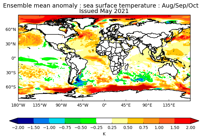
If the exceptionally above-average mid-latitude pattern persists into peak season, there’ll probably be an increased chance of having an active subtropics like 2018 or having rather strong storms above 20N, like Lee ‘17, Lorenzo ‘19, or Epsilon ‘20. A recurving MDR storm could find some very warm waters in the 15-25N range, and going from a lower to a high OHC/SST pocket could cause a phase of significant intensification. Of course, every storm is different and this speculative scenario might not happen depending on what specific recurving tracks are favored.
Regardless, the MDR will be warm enough. It remains to be seen how warm. I think I recall hearing that a cooler MDR compared to the mid-latitudes could increase unfavorable conditions (sinking air, shear, etc) over the MDR. Can someone correct me on this if I’m wrong?
Regardless, the MDR will be warm enough. It remains to be seen how warm. I think I recall hearing that a cooler MDR compared to the mid-latitudes could increase unfavorable conditions (sinking air, shear, etc) over the MDR. Can someone correct me on this if I’m wrong?
0 likes
Irene '11 Sandy '12 Hermine '16 5/15/2018 Derecho Fay '20 Isaias '20 Elsa '21 Henri '21 Ida '21
I am only a meteorology enthusiast who knows a decent amount about tropical cyclones. Look to the professional mets, the NHC, or your local weather office for the best information.
I am only a meteorology enthusiast who knows a decent amount about tropical cyclones. Look to the professional mets, the NHC, or your local weather office for the best information.
-
SFLcane
- S2K Supporter
- Posts: 10281
- Age: 48
- Joined: Sat Jun 05, 2010 1:44 pm
- Location: Lake Worth Florida
Re: 2021 Indicators: SST's / SAL / MSLP / Shear / Steering / Instability / Sat Images
Take with a grain of salt but look out Florida and Carolinas in August. 

0 likes
-
AutoPenalti
- Category 5
- Posts: 4091
- Age: 29
- Joined: Mon Aug 17, 2015 4:16 pm
- Location: Ft. Lauderdale, Florida
Re: 2021 Indicators: SST's / SAL / MSLP / Shear / Steering / Instability / Sat Images
SFLcane wrote:Take with a grain of salt but look out Florida and Carolinas in August.
https://i.imgur.com/TOZx22w.png
Azores high looks predominantly weaker.
0 likes
The posts in this forum are NOT official forecasts and should not be used as such. They are just the opinion of the poster and may or may not be backed by sound meteorological data. They are NOT endorsed by any professional institution or STORM2K. For official information, please refer to products from the NHC and NWS.
Model Runs Cheat Sheet:
GFS (5:30 AM/PM, 11:30 AM/PM)
HWRF, GFDL, UKMET, NAVGEM (6:30-8:00 AM/PM, 12:30-2:00 AM/PM)
ECMWF (1:45 AM/PM)
TCVN is a weighted averaged
-
SFLcane
- S2K Supporter
- Posts: 10281
- Age: 48
- Joined: Sat Jun 05, 2010 1:44 pm
- Location: Lake Worth Florida
Re: 2021 Indicators: SST's / SAL / MSLP / Shear / Steering / Instability / Sat Images
AutoPenalti wrote:SFLcane wrote:Take with a grain of salt but look out Florida and Carolinas in August.
https://i.imgur.com/TOZx22w.png
Azores high looks predominantly weaker.
September also looks like East Coast.

0 likes
-
Shell Mound
- Category 5
- Posts: 2432
- Age: 33
- Joined: Thu Sep 07, 2017 3:39 pm
- Location: St. Petersburg, FL → Scandinavia
Re: 2021 Indicators: SST's / SAL / MSLP / Shear / Steering / Instability / Sat Images
CyclonicFury wrote:Shell Mound wrote:SFLcane wrote:Much more active look then the Euro for sure because it warms the Atlantic. That’s the question mark I see
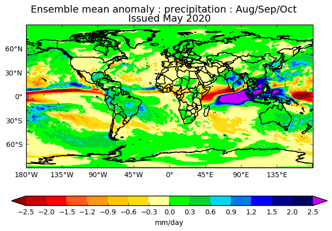
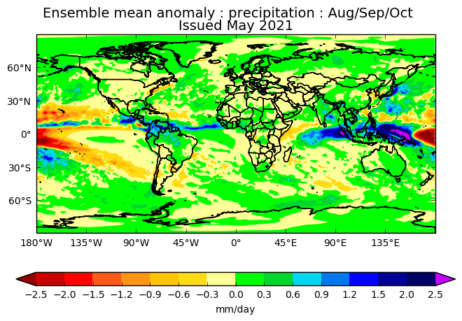
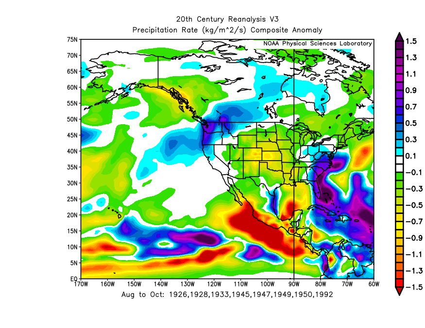
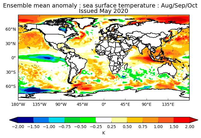
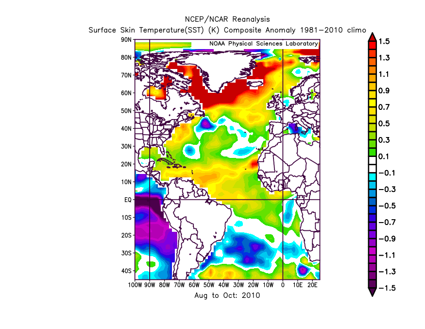
Although the UKMET is envisioning a somewhat weaker African monsoon than in 2020, it is actually showing more precipitation over the Sahel and the MDR, along with a much drier EPAC, even though the IOD and ENSO are expected to be closer to neutral than Niña. Furthermore, notably, the latest forecast signifies a stronger +AMO than the previous outlook did in 2020. On the latest run the southern half of the Caribbean looks to be roughly as wet as in 2020. Given the drier conditions over the Greater Antilles, along with a warm Gulf of Guinea, this run is likely implying a more active CV season than in 2020, because the weaker African monsoon allows storms to consolidate earlier over a warmer MDR, rather than wait until farther west. The run also seems to imply a -NAO during peak season, hence many OTS tracks and a reduced risk to FL and/or the Eastern Seaboard, as in 2010. Note the absence of abnormally dry conditions over the Great Plains during ASO, hence less of a “ridge-bridge” and a weaker, more suppressed Bermuda High than in 2020. (Incidentally, 2010 also featured a very active MDR and a strong +AMO despite a warm Gulf of Guinea.)
https://i.postimg.cc/7Pg06KWj/2020-UKMET-1.png
https://i.postimg.cc/Z5qdw45h/2021-UKMET-1.png
https://i.postimg.cc/g2Pswm86/FLprecipitation-1.png
https://i.postimg.cc/GhdYsk0t/2020-UKMET-2.png
https://i.postimg.cc/Qxm7gHsb/2021-UKMET-2.png
https://i.postimg.cc/50TtSQ2X/2010-ASOSST-1.png
It seems like you are always downplaying the risk to Florida. Of course it is possible if not likely South Florida will avoid a big hit again, but NOAA stresses every year in their preseason outlooks that you cannot predict which areas will be affected (or safe) months in advance.
Actually, in this case I am implying a reduced risk to the entire U.S. East Coast as well as peninsular Florida. The fact that the MDR is currently cooler than the subtropics as well as the global tropics implies that more sinking air, a strongly suppressive factor, will be present over the MDR. Sinking air also tends to indicate a stronger and/or more persistent TUTT, resulting in increased VWS as well as more OTS tracks due to the TUTT inducing weaknesses in the subtropical ridge (Bermuda–Azores High). Note that the ECMWF shows a pronounced TUTT over the central Atlantic, with the ridge displaced well to the north, during August and September, which would encourage more OTS tracks as well. Also, the neutral IOD and warmer Gulf of Guinea would support a weaker African monsoon than we have seen in recent seasons. Given current trends I think the forecasts that call for a very/hyperactive season, notably CSU’s, are increasingly unlikely to verify. ≥ 150 ACE and ≥ four majors? Unlikely.
As an aside, the following is quite interesting:
https://twitter.com/AndyHazelton/status/1392486699830231043
0 likes
CVW / MiamiensisWx / Shell Mound
The posts in this forum are NOT official forecasts and should not be used as such. They are just the opinion of the poster and may or may not be backed by sound meteorological data. They are NOT endorsed by any professional institution or STORM2K. For official information, please refer to products from the NHC and NWS.
-
Category5Kaiju
- Category 5
- Posts: 4335
- Joined: Thu Dec 24, 2020 12:45 pm
- Location: Seattle and Phoenix
Re: 2021 Indicators: SST's / SAL / MSLP / Shear / Steering / Instability / Sat Images
https://twitter.com/philklotzbach/status/1392860160796856325
Btw here's a recent tweet from Klotzbach that I find quite interesting. The chances of El Nino this season is very low, and La Nina (at least according to this prediction chart) could end up resurging in the fall/winter. I personally do not think the ENSO state will disfavor Atlantic activity, although things can change of course.
Btw here's a recent tweet from Klotzbach that I find quite interesting. The chances of El Nino this season is very low, and La Nina (at least according to this prediction chart) could end up resurging in the fall/winter. I personally do not think the ENSO state will disfavor Atlantic activity, although things can change of course.
0 likes
Unless explicitly stated, all info in my posts is based on my own opinions and observations. Tropical storms and hurricanes can be extremely dangerous. Refer to an accredited weather research agency or meteorologist if you need to make serious decisions regarding an approaching storm.
-
DorkyMcDorkface

- Category 5
- Posts: 1018
- Age: 28
- Joined: Mon Sep 30, 2019 1:32 pm
- Location: Mid-Atlantic
Re: 2021 Indicators: SST's / SAL / MSLP / Shear / Steering / Instability / Sat Images
1 likes
Please note the thoughts expressed by this account are solely those of the user and are from a hobbyist perspective. For more comprehensive analysis, consult an actual professional meteorologist or meteorological agency.
Floyd 1999 | Isabel 2003 | Hanna 2008 | Irene 2011 | Sandy 2012 | Isaias 2020
-
NotSparta

- Professional-Met

- Posts: 1677
- Age: 24
- Joined: Fri Aug 18, 2017 8:24 am
- Location: Naples, FL
- Contact:
Re: 2021 Indicators: SST's / SAL / MSLP / Shear / Steering / Instability / Sat Images
Shell Mound wrote:CyclonicFury wrote:Shell Mound wrote:Although the UKMET is envisioning a somewhat weaker African monsoon than in 2020, it is actually showing more precipitation over the Sahel and the MDR, along with a much drier EPAC, even though the IOD and ENSO are expected to be closer to neutral than Niña. Furthermore, notably, the latest forecast signifies a stronger +AMO than the previous outlook did in 2020. On the latest run the southern half of the Caribbean looks to be roughly as wet as in 2020. Given the drier conditions over the Greater Antilles, along with a warm Gulf of Guinea, this run is likely implying a more active CV season than in 2020, because the weaker African monsoon allows storms to consolidate earlier over a warmer MDR, rather than wait until farther west. The run also seems to imply a -NAO during peak season, hence many OTS tracks and a reduced risk to FL and/or the Eastern Seaboard, as in 2010. Note the absence of abnormally dry conditions over the Great Plains during ASO, hence less of a “ridge-bridge” and a weaker, more suppressed Bermuda High than in 2020. (Incidentally, 2010 also featured a very active MDR and a strong +AMO despite a warm Gulf of Guinea.)
https://i.postimg.cc/7Pg06KWj/2020-UKMET-1.png
https://i.postimg.cc/Z5qdw45h/2021-UKMET-1.png
https://i.postimg.cc/g2Pswm86/FLprecipitation-1.png
https://i.postimg.cc/GhdYsk0t/2020-UKMET-2.png
https://i.postimg.cc/Qxm7gHsb/2021-UKMET-2.png
https://i.postimg.cc/50TtSQ2X/2010-ASOSST-1.png
It seems like you are always downplaying the risk to Florida. Of course it is possible if not likely South Florida will avoid a big hit again, but NOAA stresses every year in their preseason outlooks that you cannot predict which areas will be affected (or safe) months in advance.
Actually, in this case I am implying a reduced risk to the entire U.S. East Coast as well as peninsular Florida. The fact that the MDR is currently cooler than the subtropics as well as the global tropics implies that more sinking air, a strongly suppressive factor, will be present over the MDR. Sinking air also tends to indicate a stronger and/or more persistent TUTT, resulting in increased VWS as well as more OTS tracks due to the TUTT inducing weaknesses in the subtropical ridge (Bermuda–Azores High). Note that the ECMWF shows a pronounced TUTT over the central Atlantic, with the ridge displaced well to the north, during August and September, which would encourage more OTS tracks as well. Also, the neutral IOD and warmer Gulf of Guinea would support a weaker African monsoon than we have seen in recent seasons. Given current trends I think the forecasts that call for a very/hyperactive season, notably CSU’s, are increasingly unlikely to verify. ≥ 150 ACE and ≥ four majors? Unlikely.
As an aside, the following is quite interesting:
https://twitter.com/AndyHazelton/status/1392486699830231043
I mean, when's the last time a cold MDR signature like this has stuck around? I'm expecting some reversal by ASO as has happened for years now, just not sure how much. You very well may be right but I'm not so confident things will stick around where they are
4 likes
This post was probably an opinion of mine, and in no way is official. Please refer to http://www.hurricanes.gov for official tropical analysis and advisories.
My website, with lots of tropical wx graphics, including satellite and recon: http://cyclonicwx.com
My website, with lots of tropical wx graphics, including satellite and recon: http://cyclonicwx.com
-
Category5Kaiju
- Category 5
- Posts: 4335
- Joined: Thu Dec 24, 2020 12:45 pm
- Location: Seattle and Phoenix
Re: 2021 Indicators: SST's / SAL / MSLP / Shear / Steering / Instability / Sat Images
DorkyMcDorkface wrote:https://twitter.com/webberweather/status/1392876883130216450
https://twitter.com/DylanFedericoWX/status/1392885296417624065
I remember this composite tweet Eric showed last year and...
1 likes
Unless explicitly stated, all info in my posts is based on my own opinions and observations. Tropical storms and hurricanes can be extremely dangerous. Refer to an accredited weather research agency or meteorologist if you need to make serious decisions regarding an approaching storm.
-
SFLcane
- S2K Supporter
- Posts: 10281
- Age: 48
- Joined: Sat Jun 05, 2010 1:44 pm
- Location: Lake Worth Florida
Re: 2021 Indicators: SST's / SAL / MSLP / Shear / Steering / Instability / Sat Images
DorkyMcDorkface wrote:https://twitter.com/webberweather/status/1392876883130216450
KABOOM! That should wake up everyone on this forum. What an active look across the Atlantic.

Last edited by SFLcane on Thu May 13, 2021 11:57 am, edited 1 time in total.
1 likes
-
Category5Kaiju
- Category 5
- Posts: 4335
- Joined: Thu Dec 24, 2020 12:45 pm
- Location: Seattle and Phoenix
Re: 2021 Indicators: SST's / SAL / MSLP / Shear / Steering / Instability / Sat Images
NotSparta wrote:Shell Mound wrote:CyclonicFury wrote:It seems like you are always downplaying the risk to Florida. Of course it is possible if not likely South Florida will avoid a big hit again, but NOAA stresses every year in their preseason outlooks that you cannot predict which areas will be affected (or safe) months in advance.
Actually, in this case I am implying a reduced risk to the entire U.S. East Coast as well as peninsular Florida. The fact that the MDR is currently cooler than the subtropics as well as the global tropics implies that more sinking air, a strongly suppressive factor, will be present over the MDR. Sinking air also tends to indicate a stronger and/or more persistent TUTT, resulting in increased VWS as well as more OTS tracks due to the TUTT inducing weaknesses in the subtropical ridge (Bermuda–Azores High). Note that the ECMWF shows a pronounced TUTT over the central Atlantic, with the ridge displaced well to the north, during August and September, which would encourage more OTS tracks as well. Also, the neutral IOD and warmer Gulf of Guinea would support a weaker African monsoon than we have seen in recent seasons. Given current trends I think the forecasts that call for a very/hyperactive season, notably CSU’s, are increasingly unlikely to verify. ≥ 150 ACE and ≥ four majors? Unlikely.
As an aside, the following is quite interesting:
https://twitter.com/AndyHazelton/status/1392486699830231043
I mean, when's the last time a cold MDR signature like this has stuck around? I'm expecting some reversal by ASO as has happened for years now, just not sure how much. You very well may be right but I'm not so confident things will stick around where they are
I believe 2014? Of course, that was an El Nino year, although I really cannot think of a recent cool neutral or La Nina year that had a cool MDR in the hurricane season's heart. Maybe 2007 is one exception, although beyond that idk entirely
0 likes
Unless explicitly stated, all info in my posts is based on my own opinions and observations. Tropical storms and hurricanes can be extremely dangerous. Refer to an accredited weather research agency or meteorologist if you need to make serious decisions regarding an approaching storm.
-
Iceresistance

- Category 5
- Posts: 9592
- Age: 22
- Joined: Sat Oct 10, 2020 9:45 am
- Location: Tecumseh, OK/Norman, OK
Re: 2021 Indicators: SST's / SAL / MSLP / Shear / Steering / Instability / Sat Images
Category5Kaiju wrote:NotSparta wrote:Shell Mound wrote:Actually, in this case I am implying a reduced risk to the entire U.S. East Coast as well as peninsular Florida. The fact that the MDR is currently cooler than the subtropics as well as the global tropics implies that more sinking air, a strongly suppressive factor, will be present over the MDR. Sinking air also tends to indicate a stronger and/or more persistent TUTT, resulting in increased VWS as well as more OTS tracks due to the TUTT inducing weaknesses in the subtropical ridge (Bermuda–Azores High). Note that the ECMWF shows a pronounced TUTT over the central Atlantic, with the ridge displaced well to the north, during August and September, which would encourage more OTS tracks as well. Also, the neutral IOD and warmer Gulf of Guinea would support a weaker African monsoon than we have seen in recent seasons. Given current trends I think the forecasts that call for a very/hyperactive season, notably CSU’s, are increasingly unlikely to verify. ≥ 150 ACE and ≥ four majors? Unlikely.
As an aside, the following is quite interesting:
https://twitter.com/AndyHazelton/status/1392486699830231043
I mean, when's the last time a cold MDR signature like this has stuck around? I'm expecting some reversal by ASO as has happened for years now, just not sure how much. You very well may be right but I'm not so confident things will stick around where they are
I believe 2014? Of course, that was an El Nino year, although I really cannot think of a recent cool neutral or La Nina year that had a cool MDR in the hurricane season's heart. Maybe 2007 is one exception, although beyond that idk entirely
2002 was also an El Nino year, but was near average . . .
0 likes
Bill 2015 & Beta 2020
Winter 2020-2021
All observations are in Tecumseh, OK unless otherwise noted.
Winter posts are focused mainly for Oklahoma & Texas.
Take any of my forecasts with a grain of salt, refer to the NWS, SPC, and NHC for official information
Never say Never with weather! Because ANYTHING is possible!
Winter 2020-2021
All observations are in Tecumseh, OK unless otherwise noted.
Winter posts are focused mainly for Oklahoma & Texas.
Take any of my forecasts with a grain of salt, refer to the NWS, SPC, and NHC for official information
Never say Never with weather! Because ANYTHING is possible!
-
Category5Kaiju
- Category 5
- Posts: 4335
- Joined: Thu Dec 24, 2020 12:45 pm
- Location: Seattle and Phoenix
Re: 2021 Indicators: SST's / SAL / MSLP / Shear / Steering / Instability / Sat Images
https://twitter.com/webberweather/status/1392914442677936128
Here's the outlook for wind shear in ASO as posted by Eric Webb. Looks like the Bahamas and Eastern Florida may need to watch out
Here's the outlook for wind shear in ASO as posted by Eric Webb. Looks like the Bahamas and Eastern Florida may need to watch out
0 likes
Unless explicitly stated, all info in my posts is based on my own opinions and observations. Tropical storms and hurricanes can be extremely dangerous. Refer to an accredited weather research agency or meteorologist if you need to make serious decisions regarding an approaching storm.
Who is online
Users browsing this forum: Bing [Bot], Old-TimeCane and 244 guests