
https://twitter.com/yconsor/status/1392926617127768065
2021 Indicators: SST's / SAL / MSLP / Shear / Steering / Instability / Sat Images
Moderator: S2k Moderators
Forum rules

The posts in this forum are NOT official forecasts and should not be used as such. They are just the opinion of the poster and may or may not be backed by sound meteorological data. They are NOT endorsed by any professional institution or STORM2K. For official information, please refer to products from the National Hurricane Center and National Weather Service.
-
SFLcane

- S2K Supporter

- Posts: 10281
- Age: 48
- Joined: Sat Jun 05, 2010 1:44 pm
- Location: Lake Worth Florida
Re: 2021 Indicators: SST's / SAL / MSLP / Shear / Steering / Instability / Sat Images
I think it fits with the idea that Atlantic activity will be east-shifted this year compared to 2020.
0 likes

Re: 2021 Indicators: SST's / SAL / MSLP / Shear / Steering / Instability / Sat Images
This time last year some were talking how "cool" the MDR was.
viewtopic.php?f=31&t=120763&start=520
SFLcane wrote:This cooling in the MDR is no bueno for those wanting an active season. Obviously could easily warm by August but we could easily end with a season like 2016.

viewtopic.php?f=31&t=120763&start=520
3 likes
-
SFLcane
- S2K Supporter
- Posts: 10281
- Age: 48
- Joined: Sat Jun 05, 2010 1:44 pm
- Location: Lake Worth Florida
Re: 2021 Indicators: SST's / SAL / MSLP / Shear / Steering / Instability / Sat Images
NDG wrote:This time last year some were talking how "cool" the MDR was.SFLcane wrote:This cooling in the MDR is no bueno for those wanting an active season. Obviously could easily warm by August but we could easily end with a season like 2016.
https://i.imgur.com/j1X1Buo.jpg
viewtopic.php?f=31&t=120763&start=520
Lol! I stated in my recent post concerning the mdr it was early and things could and will change.
0 likes
-
SFLcane
- S2K Supporter
- Posts: 10281
- Age: 48
- Joined: Sat Jun 05, 2010 1:44 pm
- Location: Lake Worth Florida
Re: 2021 Indicators: SST's / SAL / MSLP / Shear / Steering / Instability / Sat Images
If the same bias correction happened this year, the Atlantic would be favored again.
https://twitter.com/BenNollWeather/status/1392942628442832900
https://twitter.com/BenNollWeather/status/1392942628442832900
0 likes
Re: 2021 Indicators: SST's / SAL / MSLP / Shear / Steering / Instability / Sat Images
SFLcane wrote:NDG wrote:This time last year some were talking how "cool" the MDR was.SFLcane wrote:This cooling in the MDR is no bueno for those wanting an active season. Obviously could easily warm by August but we could easily end with a season like 2016.
https://i.imgur.com/j1X1Buo.jpg
viewtopic.php?f=31&t=120763&start=520
Lol! I stated in my recent post concerning the mdr it was early and things could and will change.
Glad you learned from last year
0 likes
-
SFLcane
- S2K Supporter
- Posts: 10281
- Age: 48
- Joined: Sat Jun 05, 2010 1:44 pm
- Location: Lake Worth Florida
Re: 2021 Indicators: SST's / SAL / MSLP / Shear / Steering / Instability / Sat Images
NDG wrote:SFLcane wrote:NDG wrote:This time last year some were talking how "cool" the MDR was.
viewtopic.php?f=31&t=120763&start=520
Lol! I stated in my recent post concerning the mdr it was early and things could and will change.
Glad you learned from last year
El niño is coming!
1 likes
Re: 2021 Indicators: SST's / SAL / MSLP / Shear / Steering / Instability / Sat Images
SFLcane wrote:If the same bias correction happened this year, the Atlantic would be favored again.
https://twitter.com/BenNollWeather/status/1392942628442832900
A little rising motion over the EPAC is definitely not a season cancel for the Atlantic Basin, especially when we are talking about La Nina most likely coming back during SON and a continuing -PDO.

Last edited by NDG on Thu May 13, 2021 4:15 pm, edited 1 time in total.
4 likes
-
cycloneye

- Admin

- Posts: 149508
- Age: 69
- Joined: Thu Oct 10, 2002 10:54 am
- Location: San Juan, Puerto Rico
Re: 2021 Indicators: SST's / SAL / MSLP / Shear / Steering / Instability / Sat Images
0 likes
Visit the Caribbean-Central America Weather Thread where you can find at first post web cams,radars
and observations from Caribbean basin members Click Here
and observations from Caribbean basin members Click Here
-
Category5Kaiju

- Category 5

- Posts: 4335
- Joined: Thu Dec 24, 2020 12:45 pm
- Location: Seattle and Phoenix
Re: 2021 Indicators: SST's / SAL / MSLP / Shear / Steering / Instability / Sat Images
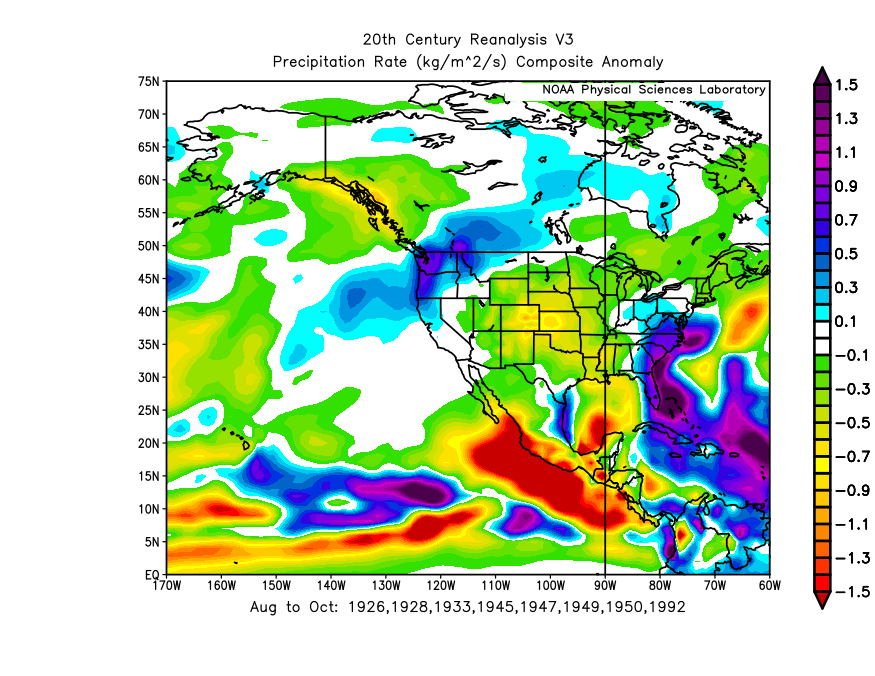
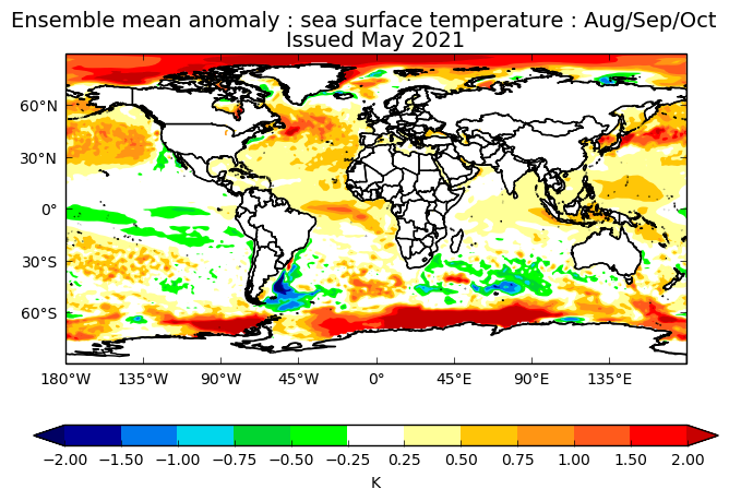
NDG wrote:SFLcane wrote:If the same bias correction happened this year, the Atlantic would be favored again.
https://twitter.com/BenNollWeather/status/1392942628442832900
A little rising motion over the EPAC is definitely not a season cancel for the Atlantic Basin, especially when we are talking about La Nina most likely coming back during SON and a continuing -PDO.
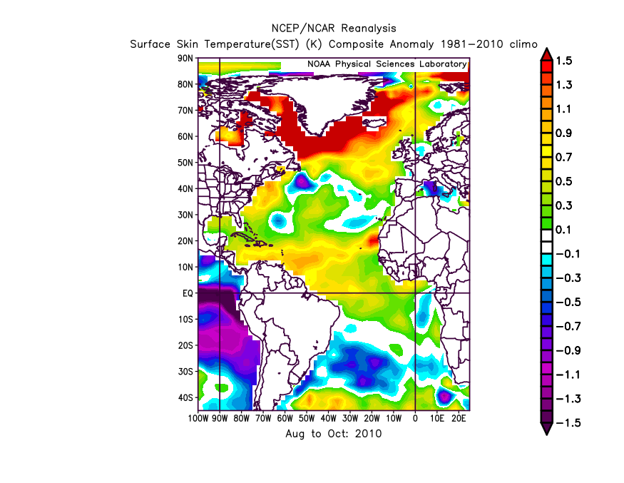
https://i.imgur.com/s4Oydnu.jpg
Hang on a sec, isn't that June-August? So in other words I wonder what the August-October composite would have looked like for those years
0 likes
Unless explicitly stated, all info in my posts is based on my own opinions and observations. Tropical storms and hurricanes can be extremely dangerous. Refer to an accredited weather research agency or meteorologist if you need to make serious decisions regarding an approaching storm.
Re: 2021 Indicators: SST's / SAL / MSLP / Shear / Steering / Instability / Sat Images
Category5Kaiju wrote:NDG wrote:SFLcane wrote:If the same bias correction happened this year, the Atlantic would be favored again.
https://twitter.com/BenNollWeather/status/1392942628442832900
A little rising motion over the EPAC is definitely not a season cancel for the Atlantic Basin, especially when we are talking about La Nina most likely coming back during SON and a continuing -PDO.
https://i.imgur.com/s4Oydnu.jpg
Hang on a sec, isn't that June-August? So in other words I wonder what the August-October composite would have looked like for those years
Not much different than Jun-Aug.
1 likes
-
Category5Kaiju
- Category 5
- Posts: 4335
- Joined: Thu Dec 24, 2020 12:45 pm
- Location: Seattle and Phoenix
Re: 2021 Indicators: SST's / SAL / MSLP / Shear / Steering / Instability / Sat Images
NDG wrote:Category5Kaiju wrote:NDG wrote:
A little rising motion over the EPAC is definitely not a season cancel for the Atlantic Basin, especially when we are talking about La Nina most likely coming back during SON and a continuing -PDO.
https://i.imgur.com/s4Oydnu.jpg
Hang on a sec, isn't that June-August? So in other words I wonder what the August-October composite would have looked like for those years
Not much different than Jun-Aug.
Oh ok
0 likes
Unless explicitly stated, all info in my posts is based on my own opinions and observations. Tropical storms and hurricanes can be extremely dangerous. Refer to an accredited weather research agency or meteorologist if you need to make serious decisions regarding an approaching storm.
-
toad strangler

- S2K Supporter
- Posts: 4546
- Joined: Sun Jul 28, 2013 3:09 pm
- Location: Earth
- Contact:
Re: 2021 Indicators: SST's / SAL / MSLP / Shear / Steering / Instability / Sat Images
SFLcane wrote:Lol! I stated in my recent post concerning the mdr it was early and things could and will change.
haha as did I yesterday IRT the hand wringing already starting about SST's. Just wait till that first big plume of SAL hits
Anyway, We are just one week away from NOAA's outlook and I'm very interested to see if it's in a similar position as CSU is.
6 likes
My Weather Station
https://www.wunderground.com/dashboard/pws/KFLPORTS603
https://www.wunderground.com/dashboard/pws/KFLPORTS603
-
Category5Kaiju
- Category 5
- Posts: 4335
- Joined: Thu Dec 24, 2020 12:45 pm
- Location: Seattle and Phoenix
Re: 2021 Indicators: SST's / SAL / MSLP / Shear / Steering / Instability / Sat Images
https://twitter.com/webberweather/status/1392999697996914689
This a medium range forecast, but it sure has caught the attention of a few mets
This a medium range forecast, but it sure has caught the attention of a few mets
0 likes
Unless explicitly stated, all info in my posts is based on my own opinions and observations. Tropical storms and hurricanes can be extremely dangerous. Refer to an accredited weather research agency or meteorologist if you need to make serious decisions regarding an approaching storm.
-
Shell Mound
- Category 5
- Posts: 2432
- Age: 33
- Joined: Thu Sep 07, 2017 3:39 pm
- Location: St. Petersburg, FL → Scandinavia
Re: 2021 Indicators: SST's / SAL / MSLP / Shear / Steering / Instability / Sat Images
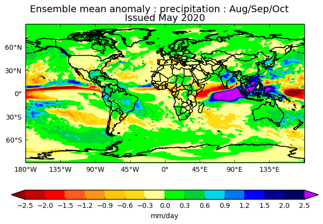
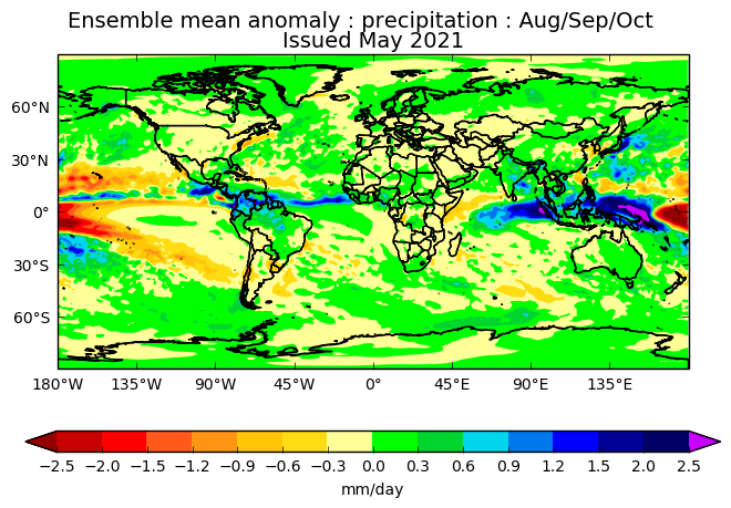
Shell Mound wrote:CyclonicFury wrote:Shell Mound wrote:Although the UKMET is envisioning a somewhat weaker African monsoon than in 2020, it is actually showing more precipitation over the Sahel and the MDR, along with a much drier EPAC, even though the IOD and ENSO are expected to be closer to neutral than Niña. Furthermore, notably, the latest forecast signifies a stronger +AMO than the previous outlook did in 2020. On the latest run the southern half of the Caribbean looks to be roughly as wet as in 2020. Given the drier conditions over the Greater Antilles, along with a warm Gulf of Guinea, this run is likely implying a more active CV season than in 2020, because the weaker African monsoon allows storms to consolidate earlier over a warmer MDR, rather than wait until farther west. The run also seems to imply a -NAO during peak season, hence many OTS tracks and a reduced risk to FL and/or the Eastern Seaboard, as in 2010. Note the absence of abnormally dry conditions over the Great Plains during ASO, hence less of a “ridge-bridge” and a weaker, more suppressed Bermuda High than in 2020. (Incidentally, 2010 also featured a very active MDR and a strong +AMO despite a warm Gulf of Guinea.)
https://i.postimg.cc/7Pg06KWj/2020-UKMET-1.png
https://i.postimg.cc/Z5qdw45h/2021-UKMET-1.png
https://i.postimg.cc/g2Pswm86/FLprecipitation-1.png
https://i.postimg.cc/GhdYsk0t/2020-UKMET-2.png
https://i.postimg.cc/Qxm7gHsb/2021-UKMET-2.png
https://i.postimg.cc/50TtSQ2X/2010-ASOSST-1.png
It seems like you are always downplaying the risk to Florida. Of course it is possible if not likely South Florida will avoid a big hit again, but NOAA stresses every year in their preseason outlooks that you cannot predict which areas will be affected (or safe) months in advance.
Actually, in this case I am implying a reduced risk to the entire U.S. East Coast as well as peninsular Florida. The fact that the MDR is currently cooler than the subtropics as well as the global tropics implies that more sinking air, a strongly suppressive factor, will be present over the MDR. Sinking air also tends to indicate a stronger and/or more persistent TUTT, resulting in increased VWS as well as more OTS tracks due to the TUTT inducing weaknesses in the subtropical ridge (Bermuda–Azores High). Note that the ECMWF shows a pronounced TUTT over the central Atlantic, with the ridge displaced well to the north, during August and September, which would encourage more OTS tracks as well. Also, the neutral IOD and warmer Gulf of Guinea would support a weaker African monsoon than we have seen in recent seasons. Given current trends I think the forecasts that call for a very/hyperactive season, notably CSU’s, are increasingly unlikely to verify. ≥ 150 ACE and ≥ four majors? Unlikely.
As an aside, the following is quite interesting:
https://twitter.com/AndyHazelton/status/1392486699830231043
https://twitter.com/AndyHazelton/status/1392915105483001856
https://twitter.com/cyclonicwx/status/1392942501171015684
Note the strong TUTT imparting enhanced westerly VWS over the eastern Caribbean and portions of the MDR. This could reduce the risk of U.S. MH landfalls.*
*According to HURDAT, roughly 75% of all U.S. MH originated in the MDR, so hostile conditions in the MDR + 2020-type African monsoon → reduced risk.
0 likes
CVW / MiamiensisWx / Shell Mound
The posts in this forum are NOT official forecasts and should not be used as such. They are just the opinion of the poster and may or may not be backed by sound meteorological data. They are NOT endorsed by any professional institution or STORM2K. For official information, please refer to products from the NHC and NWS.
-
Category5Kaiju
- Category 5
- Posts: 4335
- Joined: Thu Dec 24, 2020 12:45 pm
- Location: Seattle and Phoenix
Re: 2021 Indicators: SST's / SAL / MSLP / Shear / Steering / Instability / Sat Images
Shell Mound wrote:Shell Mound wrote:CyclonicFury wrote:It seems like you are always downplaying the risk to Florida. Of course it is possible if not likely South Florida will avoid a big hit again, but NOAA stresses every year in their preseason outlooks that you cannot predict which areas will be affected (or safe) months in advance.
Actually, in this case I am implying a reduced risk to the entire U.S. East Coast as well as peninsular Florida. The fact that the MDR is currently cooler than the subtropics as well as the global tropics implies that more sinking air, a strongly suppressive factor, will be present over the MDR. Sinking air also tends to indicate a stronger and/or more persistent TUTT, resulting in increased VWS as well as more OTS tracks due to the TUTT inducing weaknesses in the subtropical ridge (Bermuda–Azores High). Note that the ECMWF shows a pronounced TUTT over the central Atlantic, with the ridge displaced well to the north, during August and September, which would encourage more OTS tracks as well. Also, the neutral IOD and warmer Gulf of Guinea would support a weaker African monsoon than we have seen in recent seasons. Given current trends I think the forecasts that call for a very/hyperactive season, notably CSU’s, are increasingly unlikely to verify. ≥ 150 ACE and ≥ four majors? Unlikely.
As an aside, the following is quite interesting:
https://twitter.com/AndyHazelton/status/1392486699830231043
https://twitter.com/AndyHazelton/status/1392915105483001856
https://twitter.com/cyclonicwx/status/1392942501171015684
Note the strong TUTT imparting enhanced westerly VWS over the eastern Caribbean and portions of the MDR. This could reduce the risk of U.S. MH landfalls.*
*According to HURDAT, roughly 75% of all U.S. MH originated in the MDR, so hostile conditions in the MDR + 2020-type African monsoon → reduced risk.
Ok, then what about major hurricanes like Katrina, Rita, Wilma, Charley, Opal, Michael, Elena, Camille, King, and Labor Day (1935)? Those are some examples of very notable US major hurricanes that did not really originate in the MDR, so I am not exactly sure how having a hostile MDR would necessarily reduce the risk of landfalling US MHs? Don't get me wrong, I am trying not to undermine your argument, but what I am simply suggesting is at least personally, I am simply not sure if I am ready and confident to believe that this season will be a purely OTS and harmless season, I think it's way too early to think that. I'd rather wait until the ASO timeframe and see.
6 likes
Unless explicitly stated, all info in my posts is based on my own opinions and observations. Tropical storms and hurricanes can be extremely dangerous. Refer to an accredited weather research agency or meteorologist if you need to make serious decisions regarding an approaching storm.
-
Iceresistance

- Category 5
- Posts: 9592
- Age: 22
- Joined: Sat Oct 10, 2020 9:45 am
- Location: Tecumseh, OK/Norman, OK
Re: 2021 Indicators: SST's / SAL / MSLP / Shear / Steering / Instability / Sat Images
Shell Mound wrote:Shell Mound wrote:CyclonicFury wrote:It seems like you are always downplaying the risk to Florida. Of course it is possible if not likely South Florida will avoid a big hit again, but NOAA stresses every year in their preseason outlooks that you cannot predict which areas will be affected (or safe) months in advance.
Actually, in this case I am implying a reduced risk to the entire U.S. East Coast as well as peninsular Florida. The fact that the MDR is currently cooler than the subtropics as well as the global tropics implies that more sinking air, a strongly suppressive factor, will be present over the MDR. Sinking air also tends to indicate a stronger and/or more persistent TUTT, resulting in increased VWS as well as more OTS tracks due to the TUTT inducing weaknesses in the subtropical ridge (Bermuda–Azores High). Note that the ECMWF shows a pronounced TUTT over the central Atlantic, with the ridge displaced well to the north, during August and September, which would encourage more OTS tracks as well. Also, the neutral IOD and warmer Gulf of Guinea would support a weaker African monsoon than we have seen in recent seasons. Given current trends I think the forecasts that call for a very/hyperactive season, notably CSU’s, are increasingly unlikely to verify. ≥ 150 ACE and ≥ four majors? Unlikely.
As an aside, the following is quite interesting:
https://twitter.com/AndyHazelton/status/1392486699830231043
Keep in mind that Hurricanes Hanna & Isaias formed in SINKING air in Late July/Early August 2020 . . .
The Sinking phase of the MJO did NOT prevent storms from forming in 2020, it's simply made it more difficult . . .
0 likes
Bill 2015 & Beta 2020
Winter 2020-2021
All observations are in Tecumseh, OK unless otherwise noted.
Winter posts are focused mainly for Oklahoma & Texas.
Take any of my forecasts with a grain of salt, refer to the NWS, SPC, and NHC for official information
Never say Never with weather! Because ANYTHING is possible!
Winter 2020-2021
All observations are in Tecumseh, OK unless otherwise noted.
Winter posts are focused mainly for Oklahoma & Texas.
Take any of my forecasts with a grain of salt, refer to the NWS, SPC, and NHC for official information
Never say Never with weather! Because ANYTHING is possible!
-
SFLcane
- S2K Supporter
- Posts: 10281
- Age: 48
- Joined: Sat Jun 05, 2010 1:44 pm
- Location: Lake Worth Florida
Re: 2021 Indicators: SST's / SAL / MSLP / Shear / Steering / Instability / Sat Images
Shell Mound wrote:Shell Mound wrote:CyclonicFury wrote:It seems like you are always downplaying the risk to Florida. Of course it is possible if not likely South Florida will avoid a big hit again, but NOAA stresses every year in their preseason outlooks that you cannot predict which areas will be affected (or safe) months in advance.
Actually, in this case I am implying a reduced risk to the entire U.S. East Coast as well as peninsular Florida. The fact that the MDR is currently cooler than the subtropics as well as the global tropics implies that more sinking air, a strongly suppressive factor, will be present over the MDR. Sinking air also tends to indicate a stronger and/or more persistent TUTT, resulting in increased VWS as well as more OTS tracks due to the TUTT inducing weaknesses in the subtropical ridge (Bermuda–Azores High). Note that the ECMWF shows a pronounced TUTT over the central Atlantic, with the ridge displaced well to the north, during August and September, which would encourage more OTS tracks as well. Also, the neutral IOD and warmer Gulf of Guinea would support a weaker African monsoon than we have seen in recent seasons. Given current trends I think the forecasts that call for a very/hyperactive season, notably CSU’s, are increasingly unlikely to verify. ≥ 150 ACE and ≥ four majors? Unlikely.
As an aside, the following is quite interesting:
https://twitter.com/AndyHazelton/status/1392486699830231043
https://twitter.com/AndyHazelton/status/1392915105483001856
https://twitter.com/cyclonicwx/status/1392942501171015684
Note the strong TUTT imparting enhanced westerly VWS over the eastern Caribbean and portions of the MDR. This could reduce the risk of U.S. MH landfalls.*
*According to HURDAT, roughly 75% of all U.S. MH originated in the MDR, so hostile conditions in the MDR + 2020-type African monsoon → reduced risk.
I’ll save this one and revisit in Oct.
3 likes
-
weathaguyry

- Category 5
- Posts: 1273
- Age: 22
- Joined: Wed Jun 15, 2016 5:16 am
- Location: Long Island, NY
Re: 2021 Indicators: SST's / SAL / MSLP / Shear / Steering / Instability / Sat Images
If a -NAO sets up for the peak of the season, an eastern based season somewhat like 2010 could be favored over a west based one. However, the warm Gulf of Guinea and warm subtropics could lead to some dry sinking air and increased VWS over the MDR/Caribbean early on. Maybe something like 2016/2018 in August/Early September could take hold where the SAL hangs on strong until deep into August, with plenty of VWS and TUTTs preventing many of the storms from forming. Especially if the Nino regions creep warmer towards warm-neutral as we enter the hurricane season and impart some borderline Nino conditions in the Atlantic.
1 likes
My posts are only my opinions and NOT official forecasts. For official forecasts, consult the National Hurricane Center or the National Weather Service.
Irene 11', Sandy 12', Fay 20’, Isaias 20’, Elsa 21’, Henri 21’, Ida 21’
Irene 11', Sandy 12', Fay 20’, Isaias 20’, Elsa 21’, Henri 21’, Ida 21’
Who is online
Users browsing this forum: Bing [Bot], Old-TimeCane and 249 guests