a half an inch? are you kidding me?rwfromkansas wrote:NAM really dropping rain amounts for DFW. Maybe a half-inch now.
FWD may have to drop flood talk.
Texas Spring 2021
Moderator: S2k Moderators
Forum rules

The posts in this forum are NOT official forecast and should not be used as such. They are just the opinion of the poster and may or may not be backed by sound meteorological data. They are NOT endorsed by any professional institution or STORM2K.
-
starsfan65

- Category 2

- Posts: 738
- Age: 48
- Joined: Thu Dec 17, 2015 1:18 pm
- Location: Garland,Tx
Re: Texas Spring 2021
0 likes
-
rwfromkansas
- Category 5

- Posts: 2923
- Joined: Sat Aug 27, 2005 12:47 am
- Location: North Fort Worth
Re: Texas Spring 2021
starsfan65 wrote:a half an inch? are you kidding me?rwfromkansas wrote:NAM really dropping rain amounts for DFW. Maybe a half-inch now.
FWD may have to drop flood talk.
Just referring to NAM through Monday. Surely it’s underdone with GFS and Euro.
0 likes


Re: Texas Spring 2021
There's a very good connection to the Eastern Pacific moisture plume below us. Going to be tropical like downpours, very efficient rain producers.

Snippet from the WPC excessive rainfall discussion.
Snippet from the WPC excessive rainfall discussion.
Day 2
...Texas/Oklahoma...
The central U.S. will continue to see heavy precipitation amounts
as a frontal boundary slowly pushes eastward ahead of an upper
level trough axis. Model consensus over the past two days has
placed significant precipitation amounts over portions of
north-central TX into southern OK. A few models have 3 to 4+ inch
bullseyes for these areas with the majority showing at least 2 to
3 inches. Confidence for this region has increased overnight as
models continued the wet trend and thus, a Slight Risk area has
been introduced. PWAT values sit around 2 standard deviations
above climatology for this region with areas creeping near 150% of
normal over the past week in precipitation.
Day 3
...Southern/Central Plains...
This region continues to be of concern as the frontal boundary
brings continued precipitation to areas already seeing 150 to 400%
of normal. Models are struggling to come to agreement on exact
placement of this boundary, but given the history over the past
few days a Marginal Risk area has been introduced to cover pockets
of heaviest precipitation among the models. This area will likely
be adjusted as the event comes closer and models become better
aligned.
Chiari
4 likes
The above post and any post by Ntxw is NOT an official forecast and should not be used as such. It is just the opinion of the poster and may or may not be backed by sound meteorological data. It is NOT endorsed by any professional institution including Storm2k. For official information, please refer to NWS products.
Help support Storm2K!
-
bubba hotep

- S2K Supporter

- Posts: 5946
- Joined: Wed Dec 28, 2016 1:00 am
- Location: Collin County Texas

-
Brent
- S2K Supporter
- Posts: 38632
- Age: 37
- Joined: Sun May 16, 2004 10:30 pm
- Location: Tulsa Oklahoma
- Contact:
Re: Texas Spring 2021
I don't think most of y'all have to worry about not getting rain 
1 likes
#neversummer
-
Iceresistance

- Category 5
- Posts: 9537
- Age: 22
- Joined: Sat Oct 10, 2020 9:45 am
- Location: Tecumseh, OK/Norman, OK
Re: Texas Spring 2021
Brent wrote:I don't think most of y'all have to worry about not getting rain
But, the worry for flooding is increasing! I'm expecing up to 10 inches (LOCALLY), but I'm not in a flood zone, I live on top of a hill . . .
It seems like the worry for a drought can literally gets turned on it's head for the worry of flooding . . .
1 likes
Bill 2015 & Beta 2020
Winter 2020-2021
All observations are in Tecumseh, OK unless otherwise noted.
Winter posts are focused mainly for Oklahoma & Texas.
Take any of my forecasts with a grain of salt, refer to the NWS, SPC, and NHC for official information
Never say Never with weather! Because ANYTHING is possible!
Winter 2020-2021
All observations are in Tecumseh, OK unless otherwise noted.
Winter posts are focused mainly for Oklahoma & Texas.
Take any of my forecasts with a grain of salt, refer to the NWS, SPC, and NHC for official information
Never say Never with weather! Because ANYTHING is possible!
-
rwfromkansas
- Category 5
- Posts: 2923
- Joined: Sat Aug 27, 2005 12:47 am
- Location: North Fort Worth
Re: Texas Spring 2021
Yeah that seems more in line with the pattern. Hopefully flooding won’t be too bad.
0 likes
-
Iceresistance
- Category 5
- Posts: 9537
- Age: 22
- Joined: Sat Oct 10, 2020 9:45 am
- Location: Tecumseh, OK/Norman, OK
Re: Texas Spring 2021
(5/16/2021) 0z GFS QPF to +300 hours (May 28th)

Houston, we have a problem . . .

Houston, we have a problem . . .
1 likes
Bill 2015 & Beta 2020
Winter 2020-2021
All observations are in Tecumseh, OK unless otherwise noted.
Winter posts are focused mainly for Oklahoma & Texas.
Take any of my forecasts with a grain of salt, refer to the NWS, SPC, and NHC for official information
Never say Never with weather! Because ANYTHING is possible!
Winter 2020-2021
All observations are in Tecumseh, OK unless otherwise noted.
Winter posts are focused mainly for Oklahoma & Texas.
Take any of my forecasts with a grain of salt, refer to the NWS, SPC, and NHC for official information
Never say Never with weather! Because ANYTHING is possible!

Re: Texas Spring 2021
Iceresistance wrote:(5/16/2021) 0z GFS QPF to +300 hours (May 28th)
https://s3.gifyu.com/images/qpf_acc.us_sc.png
Houston, we have a problem . . .
Yeah, that amount of water over that big of an area is insane.
0 likes

-
Iceresistance
- Category 5
- Posts: 9537
- Age: 22
- Joined: Sat Oct 10, 2020 9:45 am
- Location: Tecumseh, OK/Norman, OK
Re: Texas Spring 2021
I've never seen a Moderate Risk of Flooding 3 days out from the WPC that does not include a Tropical Cyclone!


1 likes
Bill 2015 & Beta 2020
Winter 2020-2021
All observations are in Tecumseh, OK unless otherwise noted.
Winter posts are focused mainly for Oklahoma & Texas.
Take any of my forecasts with a grain of salt, refer to the NWS, SPC, and NHC for official information
Never say Never with weather! Because ANYTHING is possible!
Winter 2020-2021
All observations are in Tecumseh, OK unless otherwise noted.
Winter posts are focused mainly for Oklahoma & Texas.
Take any of my forecasts with a grain of salt, refer to the NWS, SPC, and NHC for official information
Never say Never with weather! Because ANYTHING is possible!
-
bubba hotep
- S2K Supporter
- Posts: 5946
- Joined: Wed Dec 28, 2016 1:00 am
- Location: Collin County Texas
Re: Texas Spring 2021
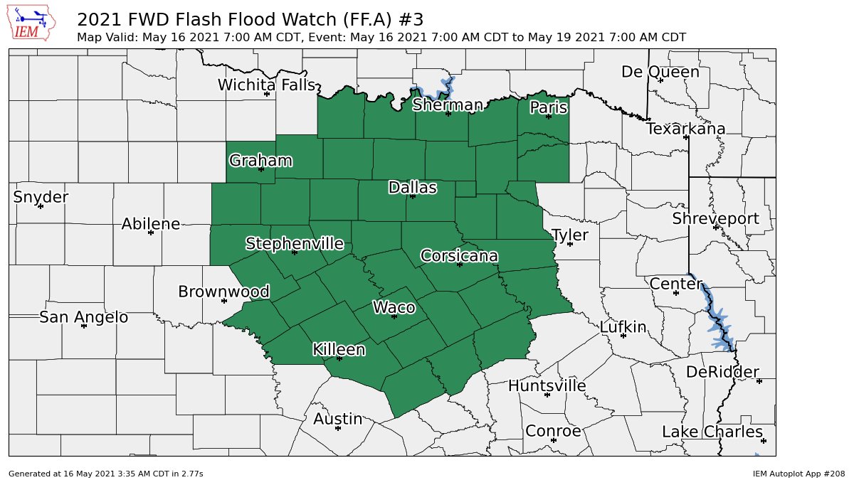
Long duration Flash Flood Watch issued for all of the FWD forecast area.
0 likes
Winter time post are almost exclusively focused on the DFW area.
Re: Texas Spring 2021
bubba hotep wrote:Long duration Flash Flood Watch issued for all of the FWD forecast area.
https://pbs.twimg.com/media/E1fw8U1VUAAtLmx?format=jpg&name=large
This is very much like the set ups in 2015 as well as Fall of 2018. EPAC plume is healthy. Those featured moderate risks of flooding. I think rainfall maxima will be somewhere in southeast TX but for much of Texas this will generate a lot of flooding.
Relying on the NAM recently you can see it has changed tune, but that's just not its wheelbarrow until up close and seeing training.
More importantly it's not just about totals, coverage/vast area is how these river and lake flooding events occur.
Day 3
Valid 12Z Tue May 18 2021 - 12Z Wed May 19 2021
...THERE IS A MODERATE RISK OF EXCESSIVE RAINFALL FROM PORTIONS OF
NE TEXAS TO SW ARKANSAS...
The upper level trough axis drops southward across the Southern
Plains during this period with strong low level winds of 35 to
40kts helping to usher in moist Gulf air into this region. PWAT
values sit near 1.5 inches with a +2 standard deviation anomaly
over in NE TX. These areas already sit at 300 to 500% of normal
and with continued rainfall forecast for Day 1 and Day 2, FFG will
just drop further. Models blanket portions of NE TX into southern
OK with QPF amounts of 3 to 5 inches with 72 hour totals reaching
near 8 inches. Confidence is high for areal flooding to occur
within NE TX and southern OK with the strongest signatures evident
across multiple models. This is where the most robust forcing for
ascent in the low/mid-levels aligned with the strongest moisture
flux anomaly. A bit more spread exists among the models the
further north you go, but the overall footprint suggests scattered
areal flooding for parts of the Central Plains and areas north of
the MO/AR/Ozarks region. However, these areas are still forecast
to have areal averages of 1 to 3 inches over nearly saturated
soils.
Given the impressive amount of moisture forecast the next 3 days
over the Southern Plains, an extensive area will likely see
numerous areas of impactful flooding for Day 3...which includes
several urban/metropolitan areas. A Moderate Risk was hoisted from
NE TX to SW AR, a Slight Risk spans from central TX to southern
MO, and a Marginal Risk encompasses most of the Southern Plains
from south-central TX northwards to KS/MO/IL. With new model
guidance adjustments may be fine tuned with future updates.
2 likes
The above post and any post by Ntxw is NOT an official forecast and should not be used as such. It is just the opinion of the poster and may or may not be backed by sound meteorological data. It is NOT endorsed by any professional institution including Storm2k. For official information, please refer to NWS products.
Help support Storm2K!
Help support Storm2K!
-
Iceresistance
- Category 5
- Posts: 9537
- Age: 22
- Joined: Sat Oct 10, 2020 9:45 am
- Location: Tecumseh, OK/Norman, OK
Re: Texas Spring 2021
Uh oh . . .
BULLETIN - EAS ACTIVATION REQUESTED
Tornado Warning
National Weather Service Corpus Christi TX
1109 AM CDT Sun May 16 2021
The National Weather Service in Corpus Christi has issued a
* Tornado Warning for...
South central Aransas County in south central Texas...
Southeastern San Patricio County in south central Texas...
* Until 1130 AM CDT.
* At 1109 AM CDT, a severe thunderstorm capable of producing a
tornado was located near Port Aransas, moving northeast at 15 mph.
HAZARD...Tornado.
SOURCE...Radar indicated rotation.
IMPACT...Flying debris will be dangerous to those caught without
shelter. Mobile homes will be damaged or destroyed.
Damage to roofs, windows, and vehicles will occur. Tree
damage is likely.
* This dangerous storm will be near...
Aransas Pass around 1115 AM CDT.
Port Aransas around 1120 AM CDT.
PRECAUTIONARY/PREPAREDNESS ACTIONS...
TAKE COVER NOW! Move to a basement or an interior room on the lowest
floor of a sturdy building. Avoid windows. If you are outdoors, in a
mobile home, or in a vehicle, move to the closest substantial shelter
and protect yourself from flying debris.
&&
LAT...LON 2781 9720 2782 9718 2782 9721 2795 9714
2787 9700 2784 9706 2784 9707 2783 9710
2783 9708 2778 9716
TIME...MOT...LOC 1609Z 236DEG 12KT 2782 9715
TORNADO...RADAR INDICATED
HAIL...0.00IN
$$
JCP
0 likes
Bill 2015 & Beta 2020
Winter 2020-2021
All observations are in Tecumseh, OK unless otherwise noted.
Winter posts are focused mainly for Oklahoma & Texas.
Take any of my forecasts with a grain of salt, refer to the NWS, SPC, and NHC for official information
Never say Never with weather! Because ANYTHING is possible!
Winter 2020-2021
All observations are in Tecumseh, OK unless otherwise noted.
Winter posts are focused mainly for Oklahoma & Texas.
Take any of my forecasts with a grain of salt, refer to the NWS, SPC, and NHC for official information
Never say Never with weather! Because ANYTHING is possible!
-
rwfromkansas
- Category 5
- Posts: 2923
- Joined: Sat Aug 27, 2005 12:47 am
- Location: North Fort Worth
Re: Texas Spring 2021
Some areas just about 20 miles or so south of me have already picked up 10” this morning and this is just day 1 
1 likes
-
bubba hotep
- S2K Supporter
- Posts: 5946
- Joined: Wed Dec 28, 2016 1:00 am
- Location: Collin County Texas
Re: Texas Spring 2021
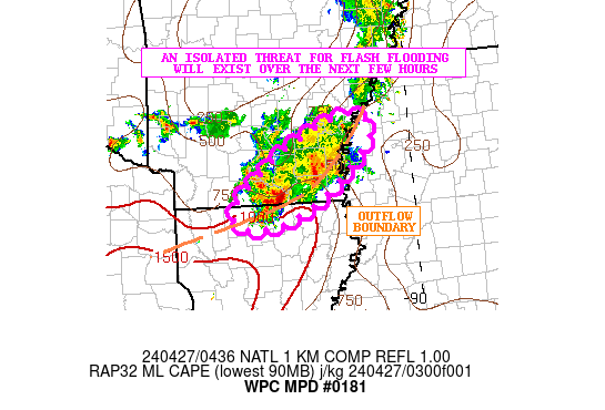
Mesoscale Precipitation Discussion 0181
NWS Weather Prediction Center College Park MD
1216 PM EDT Sun May 16 2021
Areas affected...East-Central Oklahoma through North Texas
Concerning...Heavy rainfall...Flash flooding possible
Valid 161615Z - 162115Z
Summary...Potential for flash-flooding this afternoon along a
moisture/instability axis extending from North Texas into
east-central Oklahoma.
Discussion...A mid-level impulse is lifting northeast through
central OK with an axis of moisture/instability extending north
from south TX ahead of this wave. Scattered thunderstorms have
developed in this axis over North Texas with recent max one hour
rainfall estimates from KFWS of 1.5 to locally 2" over the I-35
corridor including the Dallas metro. PWs of 1.6" to 1.7" will
continue to be reinforced by 25kt southerly 850mb flow with SBCAPE
of 500 to 1000 J/Kg. 1hr FFG is lower through the Dallas
metro/along I-35E (between 2.0" and 2.5"/hr) where the greater
moisture is present. Farther north in east-central OK are PWs
around 1.5" and 1hr FFG is generally just above 2.5"/hr. However,
the mid-level circulation should continue to allow some longer
residence time for moderate to heavy rain, making for a similar
isolated flash flood in parts of central OK to North TX this
afternoon.
Jackson
ATTN...WFO...FWD...OUN...TSA...
ATTN...RFC...ABRFC...LMRFC...WGRFC...NWC...
0 likes
Winter time post are almost exclusively focused on the DFW area.
-
bubba hotep
- S2K Supporter
- Posts: 5946
- Joined: Wed Dec 28, 2016 1:00 am
- Location: Collin County Texas
Re: Texas Spring 2021
I'm becoming increasingly convinced that this is a historic type event setting up for Texas.
4 likes
Winter time post are almost exclusively focused on the DFW area.
-
jasons2k

- Storm2k Executive

- Posts: 8275
- Age: 52
- Joined: Wed Jul 06, 2005 12:32 pm
- Location: The Woodlands, TX
Re: Texas Spring 2021
Mesoscale Discussion 0634
NWS Storm Prediction Center Norman OK
1215 PM CDT Sun May 16 2021
Areas affected...Central/East TX
Concerning...Severe potential...Watch unlikely
Valid 161715Z - 161915Z
Probability of Watch Issuance...20 percent
SUMMARY...A few strong to severe storms possible this afternoon
across portions of central and east TX. Isolated damaging wind gusts
are the primary threat.
DISCUSSION...Regional satellite and radar imagery reveals a pair of
MCVs across the southern Plains, one over central OK and the other
along the middle TX Coast. Modest southerly low-level flow exists
between these two features, roughly along and east of I-35. The
thermodynamic environment is expected to remain only marginally
buoyant, with overall buoyancy tempered by the limited diurnal
heating. Even so, thunderstorms are expected to persist while
gradually drifting eastward throughout the day.
Surface winds have been backing a bit more southeasterly just ahead
of the storms, which, when coupled with the modest low-level
southerly flow and westerly flow aloft, result in a kinematic
profile that could support a supercell or two. Damaging wind gusts
would be the primary threat with any stronger updrafts/supercells,
with some low-probability potential for a brief tornado as well.
Marginal and isolated nature of the severe threat is expected to
preclude the need for a watch.
1 likes
-
bubba hotep
- S2K Supporter
- Posts: 5946
- Joined: Wed Dec 28, 2016 1:00 am
- Location: Collin County Texas
Re: Texas Spring 2021
Flood Advisory issued for portions of Dallas County

1 likes
Winter time post are almost exclusively focused on the DFW area.
Return to “USA & Caribbean Weather”
Who is online
Users browsing this forum: No registered users and 85 guests