AL, 90, 2021052000, , BEST, 0, 304N, 598W, 30, 1013, LO,
ATL: ANA - Post-Tropical - Discussion
Moderator: S2k Moderators
-
Nancy Smar

- Category 5

- Posts: 1081
- Age: 25
- Joined: Wed Aug 16, 2017 10:03 pm
ATL: ANA - Post-Tropical - Discussion
Last edited by Nancy Smar on Sat May 22, 2021 2:23 am, edited 2 times in total.
5 likes
-
Nancy Smar
- Category 5
- Posts: 1081
- Age: 25
- Joined: Wed Aug 16, 2017 10:03 pm
Re: ATL: INVEST 90L - Discussion
AL, 90, 2021052000, , BEST, 0, 304N, 598W, 30, 1013, LO, 34, NEQ, 0, 0, 0, 0, 1017, 150, 60, 0, 0, L, 0, , 0, 0, INVEST, M, 0, , 0, 0, 0, 0, genesis-num, 001, SPAWNINVEST, al712021 to al902021,
ABNT20 KNHC 192316
TWOAT
Tropical Weather Outlook
NWS National Hurricane Center Miami FL
800 PM EDT Wed May 19 2021
For the North Atlantic...Caribbean Sea and the Gulf of Mexico:
A large area of cloudiness and thunderstorms has developed several
hundred miles east of Bermuda. A non-tropical low pressure system is
expected to form within this broad cloud system a few hundred miles
northeast of Bermuda by tomorrow and produce gale-force winds. The
low is then forecast to move westward and southwestward over warmer
waters on Friday, and will likely become a short-lived subtropical
cyclone late Friday and into the weekend near and to the northeast
of Bermuda. The system is expected to move toward the north and
northeast into a more hostile environment by late Sunday into
Monday. For more information on this developing system, please
see High Seas forecasts issued by the Ocean Prediction Center.
* Formation chance through 48 hours...low...30 percent.
* Formation chance through 5 days...medium...60 percent.
&&
High Seas Forecasts for this system can be found under AWIPS header
NFDHSFAT1, WMO header FZNT01 KWBC, and online at
ocean.weather.gov/shtml/NFDHSFAT1.php
$$
Forecaster Stewart
0 likes
-
ElectricStorm

- Category 5
- Posts: 5147
- Age: 25
- Joined: Tue Aug 13, 2019 11:23 pm
- Location: Norman, OK
Re: ATL: INVEST 90L - Discussion
Looks like this has a pretty good chance to get the May streak to 7 years... pretty crazy.
1 likes
B.S Meteorology, University of Oklahoma '25
Please refer to the NHC, NWS, or SPC for official information.
Please refer to the NHC, NWS, or SPC for official information.
-
Shell Mound
- Category 5
- Posts: 2432
- Age: 33
- Joined: Thu Sep 07, 2017 3:39 pm
- Location: St. Petersburg, FL → Scandinavia
Re: ATL: INVEST 90L - Discussion
https://twitter.com/hankd_wx/status/1395110727279681537
https://twitter.com/hankd_wx/status/1395110732228964364
https://twitter.com/hankd_wx/status/1395110735580180483
https://twitter.com/hankd_wx/status/1395110732228964364
https://twitter.com/hankd_wx/status/1395110735580180483
3 likes
CVW / MiamiensisWx / Shell Mound
The posts in this forum are NOT official forecasts and should not be used as such. They are just the opinion of the poster and may or may not be backed by sound meteorological data. They are NOT endorsed by any professional institution or STORM2K. For official information, please refer to products from the NHC and NWS.
-
DorkyMcDorkface

- Category 5
- Posts: 1017
- Age: 28
- Joined: Mon Sep 30, 2019 1:32 pm
- Location: Mid-Atlantic
Re: ATL: INVEST 90L - Discussion
Fun fact: if 90L reaches (S)TS status, it would be the third time that the name "Ana" was used on a pre-season system, the other two times being 2003 and 2015.
10 likes
Please note the thoughts expressed by this account are solely those of the user and are from a hobbyist perspective. For more comprehensive analysis, consult an actual professional meteorologist or meteorological agency.
Floyd 1999 | Isabel 2003 | Hanna 2008 | Irene 2011 | Sandy 2012 | Isaias 2020

Re: ATL: INVEST 90L - Discussion
If named, Ana would also be extend the 3-cycle streak to 4 with regards to forming in any months OTHER than June and July 
No other A name in the six lists has had this 'experience'.
2021: Ana in May?
2015: Ana in May
2009: Ana in August
2003: Ana in April
1997: Ana in June
No other A name in the six lists has had this 'experience'.
2021: Ana in May?
2015: Ana in May
2009: Ana in August
2003: Ana in April
1997: Ana in June
Last edited by Ryxn on Thu May 20, 2021 1:15 am, edited 1 time in total.
2 likes
-
CyclonicFury

- Category 5
- Posts: 2035
- Age: 27
- Joined: Sun Jul 02, 2017 12:32 pm
- Location: NC
- Contact:
Re: ATL: INVEST 90L - Discussion
50/80? That escalated quickly...
000
ABNT20 KNHC 200540
TWOAT
Tropical Weather Outlook
NWS National Hurricane Center Miami FL
200 AM EDT Thu May 20 2021
For the North Atlantic...Caribbean Sea and the Gulf of Mexico:
A non-tropical low pressure system has developed within a broad area
of cloudiness and thunderstorms about 600 miles east-southeast of
Bermuda. The low is expected to develop gale-force winds later today
while it moves generally northward. The low is forecast to move
westward and southwestward over warmer waters on Friday, and will
likely become a short-lived subtropical cyclone near and to the
northeast of Bermuda on Friday. The system is expected to move
toward the north and northeast into a more hostile environment by
late Sunday into Monday. For more information on this developing
low pressure area, please see High Seas forecasts issued by the NOAA
Ocean Prediction Center and forecast products issued by the Bermuda
Weather Service.
* Formation chance through 48 hours...medium...50 percent.
* Formation chance through 5 days...high...80 percent.
&&
High Seas Forecasts for this system can be found under AWIPS header
NFDHSFAT1, WMO header FZNT01 KWBC, and online at
ocean.weather.gov/shtml/NFDHSFAT1.php
$$
Forecaster Stewart
0 likes
NCSU B.S. in Meteorology Class of 2021. Tropical weather blogger at http://www.cyclonicfury.com. My forecasts and thoughts are NOT official, for official forecasts please consult the National Hurricane Center.
-
NXStumpy_Robothing
- Category 1

- Posts: 335
- Age: 25
- Joined: Fri Jun 05, 2020 11:50 pm
- Location: North Georgia
Re: ATL: INVEST 90L - Discussion
Seems like the NHC is all but saying they're going to need to designate this thing as a subtropical storm in the coming days. That's a pretty impressive jump in percentages, going from 0/20 to 50/80 over the past 24 hours.
With the major models being continuously enthusiastic about 90L's chances for subtropical transition (and even, in some cases, tropical transition), I can see why they're bullish. Hopefully we're not all counting our chickens before they hatch - wouldn't be the first time where a high-percentage area of interest doesn't develop as expected.
With the major models being continuously enthusiastic about 90L's chances for subtropical transition (and even, in some cases, tropical transition), I can see why they're bullish. Hopefully we're not all counting our chickens before they hatch - wouldn't be the first time where a high-percentage area of interest doesn't develop as expected.
1 likes
Undergraduate Meteorology Student, Georgia Institute of Technology
-
Shell Mound
- Category 5
- Posts: 2432
- Age: 33
- Joined: Thu Sep 07, 2017 3:39 pm
- Location: St. Petersburg, FL → Scandinavia
Re: ATL: INVEST 90L - Discussion
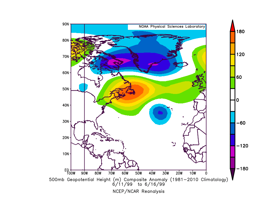
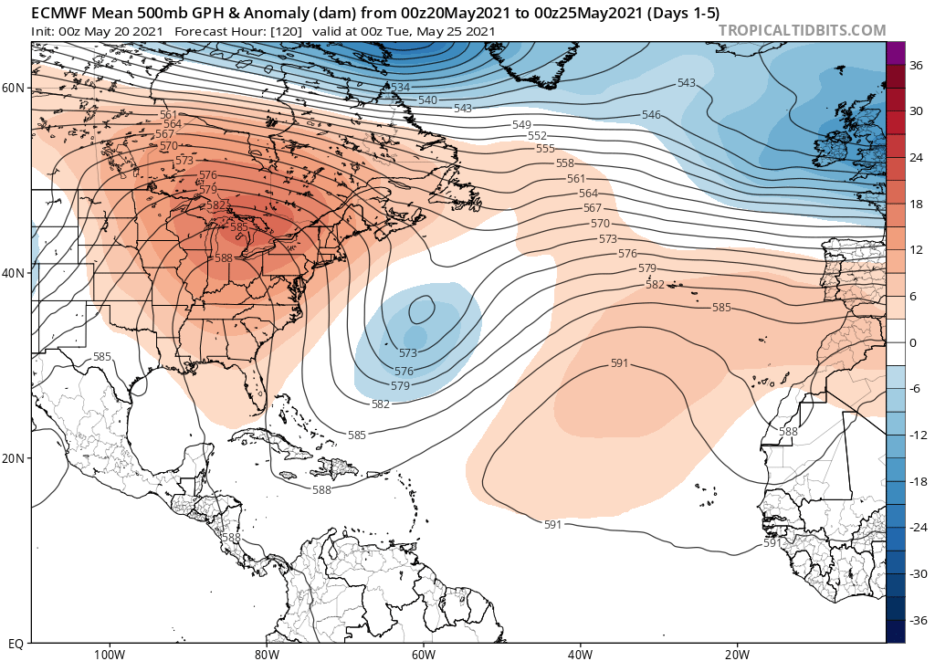
Interestingly, the location, pattern, and projected track are similar to those of Arlene (1999). 1999 is somewhat similar to 2021 in terms of SST configuration.
0 likes
CVW / MiamiensisWx / Shell Mound
The posts in this forum are NOT official forecasts and should not be used as such. They are just the opinion of the poster and may or may not be backed by sound meteorological data. They are NOT endorsed by any professional institution or STORM2K. For official information, please refer to products from the NHC and NWS.
-
Nancy Smar
- Category 5
- Posts: 1081
- Age: 25
- Joined: Wed Aug 16, 2017 10:03 pm
Re: ATL: INVEST 90L - Discussion
ABNT20 KNHC 201157
TWOAT
Tropical Weather Outlook
NWS National Hurricane Center Miami FL
800 AM EDT Thu May 20 2021
For the North Atlantic...Caribbean Sea and the Gulf of Mexico:
A non-tropical low pressure system is located about 800 miles east
of Bermuda. The low is expected to develop gale-force winds later
today while it moves generally northward. The low is then forecast
to move westward and southwestward over warmer waters tonight and
Friday, and it will likely become a subtropical cyclone near and to
the northeast of Bermuda on Friday. The system is expected to move
toward the north and northeast into a more hostile environment by
late Sunday into Monday. For more information on this developing low
pressure area, please see High Seas forecasts issued by the NOAA
Ocean Prediction Center and forecast products issued by the Bermuda
Weather Service.
* Formation chance through 48 hours...high...70 percent.
* Formation chance through 5 days...high...90 percent.
&&
High Seas Forecasts for this system can be found under AWIPS header
NFDHSFAT1, WMO header FZNT01 KWBC, and online at
ocean.weather.gov/shtml/NFDHSFAT1.php
$$
Forecaster Beven
2 likes


Re: ATL: INVEST 90L - Discussion
When was the last time a subtropical storm formed over SSTs only near 70 deg F?
0 likes
-
NotSparta

- Professional-Met

- Posts: 1677
- Age: 24
- Joined: Fri Aug 18, 2017 8:24 am
- Location: Naples, FL
- Contact:
Re: ATL: INVEST 90L - Discussion
NDG wrote:When was the last time a subtropical storm formed over SSTs only near 70 deg F?
I think 2017, with Arlene
2 likes
This post was probably an opinion of mine, and in no way is official. Please refer to http://www.hurricanes.gov for official tropical analysis and advisories.
My website, with lots of tropical wx graphics, including satellite and recon: http://cyclonicwx.com
My website, with lots of tropical wx graphics, including satellite and recon: http://cyclonicwx.com
-
cycloneye

- Admin

- Posts: 149508
- Age: 69
- Joined: Thu Oct 10, 2002 10:54 am
- Location: San Juan, Puerto Rico
Re: ATL: INVEST 90L - Discussion
90L INVEST 210520 1200 32.9N 52.3W ATL 35 1012
0 likes
Visit the Caribbean-Central America Weather Thread where you can find at first post web cams,radars
and observations from Caribbean basin members Click Here
and observations from Caribbean basin members Click Here
-
Iceresistance

- Category 5
- Posts: 9592
- Age: 22
- Joined: Sat Oct 10, 2020 9:45 am
- Location: Tecumseh, OK/Norman, OK
Re: ATL: INVEST 90L - Discussion
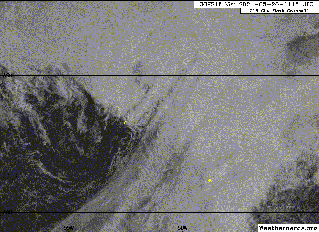
INVEST 90L plot is missing . . .
1 likes
Bill 2015 & Beta 2020
Winter 2020-2021
All observations are in Tecumseh, OK unless otherwise noted.
Winter posts are focused mainly for Oklahoma & Texas.
Take any of my forecasts with a grain of salt, refer to the NWS, SPC, and NHC for official information
Never say Never with weather! Because ANYTHING is possible!
Winter 2020-2021
All observations are in Tecumseh, OK unless otherwise noted.
Winter posts are focused mainly for Oklahoma & Texas.
Take any of my forecasts with a grain of salt, refer to the NWS, SPC, and NHC for official information
Never say Never with weather! Because ANYTHING is possible!
-
DestinHurricane

- Category 4

- Posts: 935
- Joined: Tue May 01, 2018 8:05 am
- Location: New York, NY
Re: ATL: INVEST 90L - Discussion
This will likely be a subtropical storm and won't ever become tropical. I think this won't be the last subtropical storm we see, this year's setup looks particularly favorable to these types of storms. Reminds me of 2019 in a lot of ways, this storm being similar to Andrea.
0 likes
Michael 2018
-
Sciencerocks
- Category 5
- Posts: 10186
- Age: 40
- Joined: Thu Jul 06, 2017 1:51 am

Re: ATL: INVEST 90L - Discussion
I think this will be the first of many storms in the subtropics this year. I'll have to watch out here in Bermuda.
1 likes
Igor 2010, Sandy 2012, Fay 2014, Gonzalo 2014, Joaquin 2015, Nicole 2016, Humberto 2019, Imelda 2025
I am only a tropical weather enthusiast. My predictions are not official and may or may not be backed by sound meteorological data. For official information, please refer to the NHC and NWS products.
I am only a tropical weather enthusiast. My predictions are not official and may or may not be backed by sound meteorological data. For official information, please refer to the NHC and NWS products.
-
cycloneye
- Admin
- Posts: 149508
- Age: 69
- Joined: Thu Oct 10, 2002 10:54 am
- Location: San Juan, Puerto Rico
Re: ATL: INVEST 90L - Discussion
Tropical Weather Outlook
NWS National Hurricane Center Miami FL
200 PM EDT Thu May 20 2021
For the North Atlantic...Caribbean Sea and the Gulf of Mexico:
A non-tropical low pressure system located about 650 miles east-
northeast of Bermuda is now moving northward, and recent satellite
wind data indicate that the system has gale-force winds. The low
is expected to turn westward and west-southwestward over warmer
waters tonight and Friday, and it will likely become a subtropical
cyclone near and to the northeast of Bermuda on Friday. After that
time, the system is expected to move toward the north and northeast
into a more hostile environment by late Sunday into Monday. For more
information on this developing low pressure area, please see High
Seas forecasts issued by the NOAA Ocean Prediction Center and
forecast products, including a tropical storm watch, issued by the
Bermuda Weather Service.
* Formation chance through 48 hours...high...80 percent.
* Formation chance through 5 days...high...90 percent.
&&
High Seas Forecasts for this system can be found under AWIPS header
NFDHSFAT1, WMO header FZNT01 KWBC, and online at
ocean.weather.gov/shtml/NFDHSFAT1.php
$$
Forecaster Beven
0 likes
Visit the Caribbean-Central America Weather Thread where you can find at first post web cams,radars
and observations from Caribbean basin members Click Here
and observations from Caribbean basin members Click Here
-
cycloneye
- Admin
- Posts: 149508
- Age: 69
- Joined: Thu Oct 10, 2002 10:54 am
- Location: San Juan, Puerto Rico
Re: ATL: INVEST 90L - Discussion
90L INVEST 210520 1800 34.4N 53.7W ATL 40 1011
0 likes
Visit the Caribbean-Central America Weather Thread where you can find at first post web cams,radars
and observations from Caribbean basin members Click Here
and observations from Caribbean basin members Click Here

Who is online
Users browsing this forum: No registered users and 32 guests