ATL: INVEST 91L - Discussion
Moderator: S2k Moderators
-
Sciencerocks
- Category 5

- Posts: 10186
- Age: 40
- Joined: Thu Jul 06, 2017 1:51 am
-
wxman57

- Moderator-Pro Met

- Posts: 23175
- Age: 68
- Joined: Sat Jun 21, 2003 8:06 pm
- Location: Houston, TX (southwest)
Re: ATL: INVEST 91L - Discussion
I think NHC may go 50%-70% chance of development in their next outlook. We are initiating advisories on the disturbance now. Moves inland near Matagorda Bay around 1am tomorrow as a depression.
9 likes
-
AutoPenalti
- Category 5
- Posts: 4091
- Age: 29
- Joined: Mon Aug 17, 2015 4:16 pm
- Location: Ft. Lauderdale, Florida
Re: ATL: INVEST 91L - Discussion
Daytime heating may help generate some convection but I don't think it will be enough to make it classifiable.
1 likes
The posts in this forum are NOT official forecasts and should not be used as such. They are just the opinion of the poster and may or may not be backed by sound meteorological data. They are NOT endorsed by any professional institution or STORM2K. For official information, please refer to products from the NHC and NWS.
Model Runs Cheat Sheet:
GFS (5:30 AM/PM, 11:30 AM/PM)
HWRF, GFDL, UKMET, NAVGEM (6:30-8:00 AM/PM, 12:30-2:00 AM/PM)
ECMWF (1:45 AM/PM)
TCVN is a weighted averaged
-
lrak

- S2K Supporter

- Posts: 1770
- Age: 59
- Joined: Thu Jun 21, 2007 2:48 pm
- Location: Corpus Christi, TX
Re: ATL: INVEST 91L - Discussion
Waxing boards!!!
Surf!!! And it's still a little cold lol
Surf!!! And it's still a little cold lol
3 likes
AKA karl
Also
Personal Forecast Disclaimer:
My posts on this forum are NOT official forecast and should not be used as such. My posts are my basic observations and are definitely not backed by any "well some" meteorological knowledge. For official information, please refer to the NHC and NWS products.
Also
Personal Forecast Disclaimer:
My posts on this forum are NOT official forecast and should not be used as such. My posts are my basic observations and are definitely not backed by any "well some" meteorological knowledge. For official information, please refer to the NHC and NWS products.
-
wxman57
- Moderator-Pro Met
- Posts: 23175
- Age: 68
- Joined: Sat Jun 21, 2003 8:06 pm
- Location: Houston, TX (southwest)
Re: ATL: INVEST 91L - Discussion
lrak wrote:Waxing boards!!!
Surf!!! And it's still a little cold lol
Winds are stronger away from this weak low.
1 likes
-
lrak
- S2K Supporter
- Posts: 1770
- Age: 59
- Joined: Thu Jun 21, 2007 2:48 pm
- Location: Corpus Christi, TX
Re: ATL: INVEST 91L - Discussion
Thanks wxman57,
hoping for a little west to northwest wind on Sunday with a long period swell from the east.
The long tail down to the BOC is impressive IMO
hoping for a little west to northwest wind on Sunday with a long period swell from the east.
The long tail down to the BOC is impressive IMO
0 likes
AKA karl
Also
Personal Forecast Disclaimer:
My posts on this forum are NOT official forecast and should not be used as such. My posts are my basic observations and are definitely not backed by any "well some" meteorological knowledge. For official information, please refer to the NHC and NWS products.
Also
Personal Forecast Disclaimer:
My posts on this forum are NOT official forecast and should not be used as such. My posts are my basic observations and are definitely not backed by any "well some" meteorological knowledge. For official information, please refer to the NHC and NWS products.
-
DestinHurricane

- Category 4

- Posts: 935
- Joined: Tue May 01, 2018 8:05 am
- Location: New York, NY
Re: ATL: INVEST 91L - Discussion
I'm not seeing any sign of convection firing on the east side. The dry air really killed this one.
0 likes
Michael 2018

Re: ATL: INVEST 91L - Discussion
I think this one won't have enough time to be classified. 90L only seems a matter of time before it becomes Ana. But theoretically, if both 90L and 91L get named it would only be the 6th time since 1851 that there are 2 depressions in May. The previous times were 1887 (2 TS's), 1951 (cat 1 & TD), 1954 (TD & TS), 1969 (2 TD's), 2012 (2 TS's) and 2020 (2 TS's). Neglecting TD's the only years left would be 1887, 2012 and 2020.
0 likes
-
wxman57
- Moderator-Pro Met
- Posts: 23175
- Age: 68
- Joined: Sat Jun 21, 2003 8:06 pm
- Location: Houston, TX (southwest)
Re: ATL: INVEST 91L - Discussion
lrak wrote:Thanks wxman57,
hoping for a little west to northwest wind on Sunday with a long period swell from the east.
The long tail down to the BOC is impressive IMO
Keep hoping. That wind on Sunday will likely be from the ESE at near 20 kts
0 likes
-
lrak
- S2K Supporter
- Posts: 1770
- Age: 59
- Joined: Thu Jun 21, 2007 2:48 pm
- Location: Corpus Christi, TX
Re: ATL: INVEST 91L - Discussion
wxman57 wrote:lrak wrote:Thanks wxman57,
hoping for a little west to northwest wind on Sunday with a long period swell from the east.
The long tail down to the BOC is impressive IMO
Keep hoping. That wind on Sunday will likely be from the ESE at near 20 kts
Ugh....I will
0 likes
AKA karl
Also
Personal Forecast Disclaimer:
My posts on this forum are NOT official forecast and should not be used as such. My posts are my basic observations and are definitely not backed by any "well some" meteorological knowledge. For official information, please refer to the NHC and NWS products.
Also
Personal Forecast Disclaimer:
My posts on this forum are NOT official forecast and should not be used as such. My posts are my basic observations and are definitely not backed by any "well some" meteorological knowledge. For official information, please refer to the NHC and NWS products.

Re: ATL: INVEST 91L - Discussion
lrak wrote:wxman57 wrote:lrak wrote:Thanks wxman57,
hoping for a little west to northwest wind on Sunday with a long period swell from the east.
The long tail down to the BOC is impressive IMO
Keep hoping. That wind on Sunday will likely be from the ESE at near 20 kts
Ugh....I will
CC is always windy. Every time I go there the wind is nuts.
0 likes
-
ElectricStorm

- Category 5
- Posts: 5148
- Age: 25
- Joined: Tue Aug 13, 2019 11:23 pm
- Location: Norman, OK
Re: ATL: INVEST 91L - Discussion
Yeah I don't see this one getting classified before it runs out of time. Hopefully the rain stays away from all the already flooded areas.
0 likes
B.S Meteorology, University of Oklahoma '25
Please refer to the NHC, NWS, or SPC for official information.
Please refer to the NHC, NWS, or SPC for official information.
-
AnnularCane

- S2K Supporter
- Posts: 2963
- Joined: Thu Jun 08, 2006 9:18 am
- Location: Wytheville, VA
Re: ATL: INVEST 91L - Discussion
Weather Dude wrote:Yeah I don't see this one getting classified before it runs out of time. Hopefully the rain stays away from all the already flooded areas.
You're probably right but after Bertha last year, I wouldn't be too surprised.
1 likes
"But it never rained rain. It never snowed snow. And it never blew just wind. It rained things like soup and juice. It snowed mashed potatoes and green peas. And sometimes the wind blew in storms of hamburgers." -- Judi Barrett, Cloudy with a Chance of Meatballs
-
HurricaneBrain

- S2K Supporter
- Posts: 520
- Joined: Thu Jun 30, 2011 2:07 pm
-
wxman57
- Moderator-Pro Met
- Posts: 23175
- Age: 68
- Joined: Sat Jun 21, 2003 8:06 pm
- Location: Houston, TX (southwest)
Re: ATL: INVEST 91L - Discussion
I had figured NHC would go 50-70% for 91L at 18Z and they're 60%. They will almost certainly start PTC advisories at 4pm. Inland near Mataorda Bay by early tomorrow morning. Not much time.
6 likes

Re: ATL: INVEST 91L - Discussion
Salute!
Along the coast here for last few days, the original GoM low did enuf damage, but it was kinda unsure which way to go and basically sat there and it rained like hell over SE Texas and south Louisiana. Over here in the Panhandle, we were looking hard, but the upper level steering and such kept the thing west.
The new low is on its own, but if it was another hundred miles further south, I would give it a name on Saturday. Apparently the same steering as we saw with the rainmaker this week is in action, and maybe a buncha rain in south Texas, but that's all.
I am still holding out for prediction of no named storm before Memorial Day Somehow, conditions do not resemble what I saw in the 50's and 60's with Audrey and Alma. Had some other in the 90's along the Coast here, but nothing to write home about.
Gums sends...
3 likes
-
Sciencerocks
- Category 5
- Posts: 10186
- Age: 40
- Joined: Thu Jul 06, 2017 1:51 am
Re: ATL: INVEST 91L - Discussion
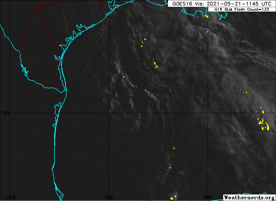
Surface observations and recent satellite wind data indicate that a
well-defined low pressure system over the western Gulf of Mexico has
winds of 30-35 mph near and east of the center. The associated
shower and thunderstorm activity remains limited, but any increase
in this activity may result in the formation of a short-lived
tropical depression or storm before the system moves inland over the
northwestern Gulf coast tonight, and potential tropical cyclone
advisories may be needed as early as this afternoon. Regardless of
development, the system could produce heavy rainfall over portions
of southeastern Texas and southwestern Louisiana through Saturday.
Given the complete saturation of soils with ongoing river flooding
along the Texas and Louisiana coastal areas, heavy rain could lead
to flash, urban, and additional riverine flooding across this
region. Additional information on the rainfall and flooding
potential can be found in products issued by your local National
Weather Service Forecast Office.
* Formation chance through 48 hours...medium...60 percent.
* Formation chance through 5 days...medium...60 percent.
0 likes

Re: ATL: INVEST 91L - Discussion
Starting to pick up a little convection over the warm core so I'd classify it as a depression now.
4 likes

Re: ATL: INVEST 91L - Discussion
1 likes
Andy D
(For official information, please refer to the NHC and NWS products.)
(For official information, please refer to the NHC and NWS products.)
-
Sciencerocks
- Category 5
- Posts: 10186
- Age: 40
- Joined: Thu Jul 06, 2017 1:51 am
Re: ATL: INVEST 91L - Discussion
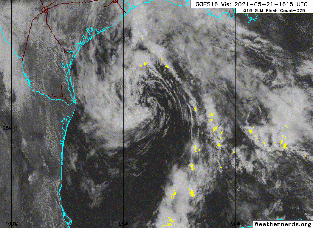
With the increase of convection near the center I agree that it is deserving.
1 likes
Who is online
Users browsing this forum: No registered users and 41 guests