Tropical Weather Outlook...Corrected
NWS National Hurricane Center Miami FL
200 PM EDT Fri May 21 2021
Corrected to add mention of gale-force winds for the Atlantic low
For the North Atlantic...Caribbean Sea and the Gulf of Mexico:
Showers and thunderstorms associated with a non-tropical low
pressure area centered about 300 miles northeast of Bermuda have
diminished somewhat over the past several hours, and the system has
not yet acquired subtropical storm characteristics. However,
the low is producing gale-force winds, and any increase in
organization would result in advisories being initiated on the
system later today or tonight as it moves westward to
west-southwestward to the northeast of Bermuda. Subsequently,
the low is forecast to move northeastward into a more hostile
environment by Saturday night or Sunday. Additional information on
this low pressure area can be found in High Seas forecasts issued by
the NOAA Ocean Prediction Center and forecast products, including a
tropical storm watch, issued by the Bermuda Weather Service.
* Formation chance through 48 hours...high...90 percent.
* Formation chance through 5 days...high...90 percent.
ATL: ANA - Post-Tropical - Discussion
Moderator: S2k Moderators
-
Sciencerocks
- Category 5

- Posts: 10186
- Age: 40
- Joined: Thu Jul 06, 2017 1:51 am
Re: ATL: INVEST 90L - Discussion
0 likes
-
DorkyMcDorkface

- Category 5
- Posts: 1017
- Age: 28
- Joined: Mon Sep 30, 2019 1:32 pm
- Location: Mid-Atlantic
Re: ATL: INVEST 90L - Discussion
Convective activity has waned significantly but the overall lower level structure remains decent:

1 likes
Please note the thoughts expressed by this account are solely those of the user and are from a hobbyist perspective. For more comprehensive analysis, consult an actual professional meteorologist or meteorological agency.
Floyd 1999 | Isabel 2003 | Hanna 2008 | Irene 2011 | Sandy 2012 | Isaias 2020
-
EquusStorm
- Category 5
- Posts: 1649
- Age: 35
- Joined: Thu Nov 07, 2013 1:04 pm
- Location: Jasper, AL
- Contact:
Re: ATL: INVEST 90L - Discussion
Gawd we are so close for BOTH of these with just a little more convection. On the edge of my seat here, running out of time
1 likes
Colors of lost purpose on the canvas of irrelevance
Not a meteorologist, in fact more of an idiot than anything. You should probably check with the NHC or a local NWS office for official information.
Not a meteorologist, in fact more of an idiot than anything. You should probably check with the NHC or a local NWS office for official information.

Re: ATL: INVEST 90L - Discussion
EquusStorm wrote:Gawd we are so close for BOTH of these with just a little more convection. On the edge of my seat here, running out of time
Now it’s a race to see which storm gets named first. 91L is finally starting to flare up some convection so it could be a TD soon. 90L has limited convection but more time and a strong LLC, and over the last hour some more has been glaring up on the east side.
0 likes
Irene '11 Sandy '12 Hermine '16 5/15/2018 Derecho Fay '20 Isaias '20 Elsa '21 Henri '21 Ida '21
I am only a meteorology enthusiast who knows a decent amount about tropical cyclones. Look to the professional mets, the NHC, or your local weather office for the best information.
I am only a meteorology enthusiast who knows a decent amount about tropical cyclones. Look to the professional mets, the NHC, or your local weather office for the best information.
-
Sciencerocks
- Category 5
- Posts: 10186
- Age: 40
- Joined: Thu Jul 06, 2017 1:51 am


Re: ATL: INVEST 90L - Discussion
I think time along with overall dynamics suggest 91 has the better chance of actually getting named.... BUT this will too require increased convection. I'm a little confused by NHS though - "Showers & thunderstorms have diminished somewhat.....". Yet they increased to 90%? Aside from further drop in pressures, would baroclinic forcing alone enhance short term convective increase near center?
Prediction: 91L gets classified as TD first, but 90L gets tagged as STS (Ana)
Prediction: 91L gets classified as TD first, but 90L gets tagged as STS (Ana)
0 likes
Andy D
(For official information, please refer to the NHC and NWS products.)
(For official information, please refer to the NHC and NWS products.)
-
InfernoFlameCat

- Category 5
- Posts: 2127
- Age: 22
- Joined: Mon Dec 14, 2020 10:52 am
- Location: Buford, GA
Re: ATL: INVEST 90L - Discussion
Dude Invest 90 is Thisclose to being named. I see deep convection wrapping around the northern half. This is really close to being named.
0 likes
I am by no means a professional. DO NOT look at my forecasts for official information or make decisions based on what I post.
Goal: to become a registered expert over tropical and subtropical cyclones.
Goal: to become a registered expert over tropical and subtropical cyclones.

Re: ATL: INVEST 90L - Discussion
It would be ironic if, being at 90%, we end up not seeing convection build further and ends up never being designated.
1 likes
The above post is not official and should not be used as such. It is the opinion of the poster and may or may not be backed by sound meteorological data. It is not endorsed by any professional institution or storm2k.org. For official information, please refer to the NHC and NWS products.
-
JW-_-

-
cycloneye

- Admin

- Posts: 149508
- Age: 69
- Joined: Thu Oct 10, 2002 10:54 am
- Location: San Juan, Puerto Rico
Re: ATL: INVEST 90L - Discussion
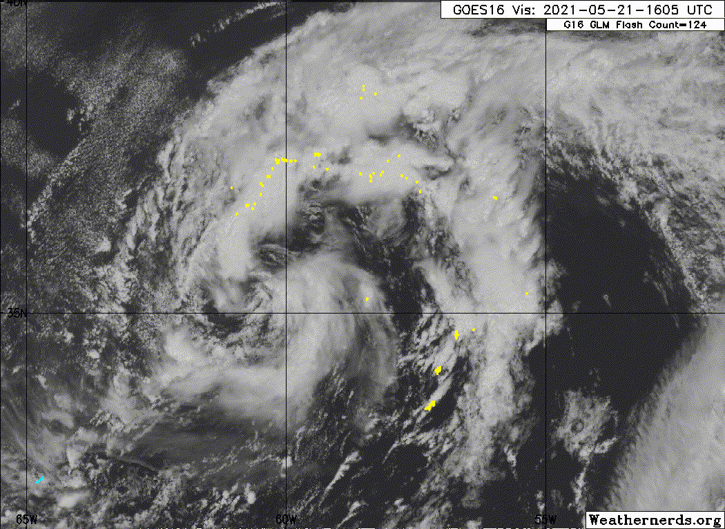
Recent satellite images indicate that the area of low pressure
located about 250 miles northeast of Bermuda is well-defined and is
gradually acquiring subtropical characteristics. In addition,
earlier satellite-derived wind data revealed that the system is
producing gale-force winds. The associated shower and thunderstorm
activity has increased slightly over the past several hours. If that
trend continues, it would result in advisories being initiated on
the system later tonight or Saturday morning while it moves slowly
westward to west-southwestward to the northeast of Bermuda. The
low is forecast to move northeastward into a more hostile
environment by Saturday night or Sunday and the systems development
chances diminish after that time. Additional information on this
low pressure area can be found in High Seas forecasts issued by the
NOAA Ocean Prediction Center and forecast products, including a
tropical storm watch, issued by the Bermuda Weather Service.
* Formation chance through 48 hours...high...90 percent.
* Formation chance through 5 days...high...90 percent.
0 likes
Visit the Caribbean-Central America Weather Thread where you can find at first post web cams,radars
and observations from Caribbean basin members Click Here
and observations from Caribbean basin members Click Here
-
JW-_-
Re: ATL: INVEST 90L - Discussion
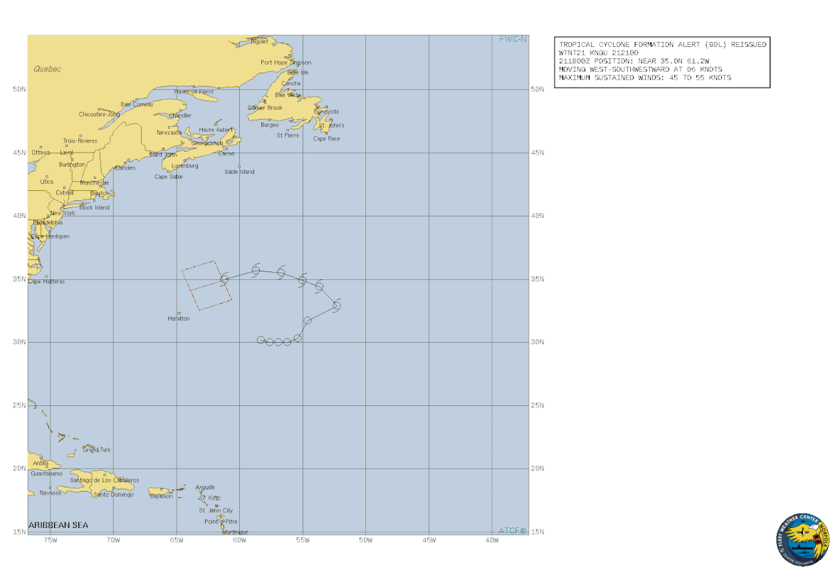
2. A NON-TROPICAL LOW PRESSURE SYSTEM IS SITUATED ABOUT 250 NM
NORTHEAST OF BERMUDA. SATELLITE DERIVED WIND DATA INDICATE THAT
THE SYSTEM IS PRODUCING GALE-FORCE WINDS THAT EXTEND A FEW
HUNDRED MILES NORTH OF THE SURFACE CENTER. SHOWER AND
THUNDERSTORM ACTIVITY IS GRADUALLY BECOMING BETTER ORGANIZED AND
THIS CONVECTIVE TREND SHOULD CONTINUE THROUGH TONIGHT AND SATURDAY
AS THE SYSTEM REMAINS OVER WARMER OCEANIC TEMPERATURES.
CONSEQUENTLY, A SUBTROPICAL DEPRESSION OR STORM IS LIKELY TO FORM
TONIGHT OR SATURDAY MORNING AS THE LOW CONTINUES TO MOVE
WEST-SOUTHWESTWARD, REMAINING NORTHEAST OF BERMUDA.
3. THIS ALERT SUPERSEDES REF A. THIS ALERT WILL BE REISSUED, UPGRADED TO
WARNING OR CANCELLED BY 222100Z.
https://www.metoc.navy.mil/fwcn/product ... 902021.txt
0 likes
-
Sciencerocks
- Category 5
- Posts: 10186
- Age: 40
- Joined: Thu Jul 06, 2017 1:51 am
-
cycloneye
- Admin
- Posts: 149508
- Age: 69
- Joined: Thu Oct 10, 2002 10:54 am
- Location: San Juan, Puerto Rico
Re: ATL: INVEST 90L - Discussion
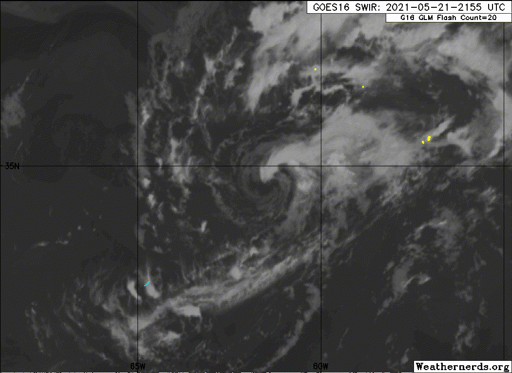
No upgrade at 11 PM.
1 likes
Visit the Caribbean-Central America Weather Thread where you can find at first post web cams,radars
and observations from Caribbean basin members Click Here
and observations from Caribbean basin members Click Here
-
Sciencerocks
- Category 5
- Posts: 10186
- Age: 40
- Joined: Thu Jul 06, 2017 1:51 am
Re: ATL: INVEST 90L - Discussion
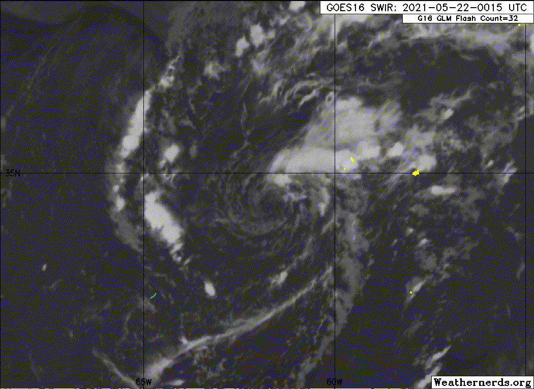
Big increase in convection near the center. This should allow it to be upgraded at 5am.
8 likes

Re: ATL: INVEST 90L - Discussion
If this holds up, we have Ana.

3 likes
Kendall -> SLO -> PBC
Memorable Storms: Katrina (for its Florida landfall...) Wilma Matthew Irma
Memorable Storms: Katrina (for its Florida landfall...) Wilma Matthew Irma
-
Nancy Smar

- Category 5
- Posts: 1081
- Age: 25
- Joined: Wed Aug 16, 2017 10:03 pm
Re: ATL: INVEST 90L - Discussion
Satellite images indicate that the well-defined low pressure area
located about 200 miles northeast of Bermuda continues to produce
gale-force winds and appears to have acquired subtropical
characteristics. In addition, thunderstorm activity has been
gradually increasing near the center, and if that trend continues
advisories will be issued later this morning. The low is expected
to move little today, remaining in the vicinity of Bermuda, but it
is forecast to turn northeastward and move into a more hostile
environment on Sunday. Additional information on this low pressure
area can be found in High Seas forecasts issued by the NOAA Ocean
Prediction Center and forecast products, including a tropical storm
watch, issued by the Bermuda Weather Service.
* Formation chance through 48 hours...high...near 100 percent.
* Formation chance through 5 days...high...near 100 percent.
1 likes
-
JW-_-
Re: ATL: INVEST 90L - Discussion


Needs upgrading to at least, TLC
STS: Subtropical Storm a cyclone with 35kt+ winds, but having both tropical and extratropical characteristics
Last edited by JW-_- on Sat May 22, 2021 1:52 am, edited 1 time in total.
0 likes

Re: ATL: INVEST 90L - Discussion
AL, 90, 2021052206, , BEST, 0, 342N, 621W, 40, 1006, SS, 34, NEQ, 180, 0, 0, 150, 1018, 250, 60, 0, 0, L, 0, , 0, 0, INVEST, M, 0, , 0, 0, 0, 0, genesis-num, 001,
1 likes
-
Nancy Smar
- Category 5
- Posts: 1081
- Age: 25
- Joined: Wed Aug 16, 2017 10:03 pm
Re: ATL: INVEST 90L - Discussion
Subtrop wrote:AL, 90, 2021052206, , BEST, 0, 342N, 621W, 40, 1006, SS, 34, NEQ, 180, 0, 0, 150, 1018, 250, 60, 0, 0, L, 0, , 0, 0, INVEST, M, 0, , 0, 0, 0, 0, genesis-num, 001,
ANA, AL, L, , , , , 01, 2021, SS, O, 2021051618, 9999999999, , 001, , , 8, METWATCH, , AL012021
3 likes
-
Nancy Smar
- Category 5
- Posts: 1081
- Age: 25
- Joined: Wed Aug 16, 2017 10:03 pm
Re: ATL: INVEST 90L - Discussion
AL, 01, 2021052206, , BEST, 0, 342N, 621W, 40, 1006, SS, 34, NEQ, 180, 0, 0, 150, 1018, 250, 60, 0, 0, L, 0, , 0, 0, ANA, M, 0, , 0, 0, 0, 0, genesis-num, 001, TRANSITIONED, alA02021 to al012021,
3 likes
Who is online
Users browsing this forum: No registered users and 23 guests