
ATL: ANA - Post-Tropical - Discussion
Moderator: S2k Moderators
-
EquusStorm
- Category 5

- Posts: 1649
- Age: 35
- Joined: Thu Nov 07, 2013 1:04 pm
- Location: Jasper, AL
- Contact:
Re: ATL: ANA - Subtropical Storm - Discussion
Thrilled it pulled it off and kept the preseason streak going; convection is seriously impressive over the center right now for the sea surface temps and conditions
7 likes
Colors of lost purpose on the canvas of irrelevance
Not a meteorologist, in fact more of an idiot than anything. You should probably check with the NHC or a local NWS office for official information.
Not a meteorologist, in fact more of an idiot than anything. You should probably check with the NHC or a local NWS office for official information.
-
JW-_-
-
Nancy Smar

- Category 5
- Posts: 1081
- Age: 25
- Joined: Wed Aug 16, 2017 10:03 pm
Re: ATL: ANA - Subtropical Storm - Discussion
Recently formed Subtropical Storm Ana remains to the northeast and will continue to drift nearby today before quickly lifting away to the northeast on Sunday. Breezy conditions and periods of showers continue before easing and drying in time for Sunday. Monday then sees the return to fair skies before the gradual approach of a trough and front from the north, poised to reintroduce wet weather. A tropical storm watch remains in effect.
0 likes
-
EquusStorm
- Category 5
- Posts: 1649
- Age: 35
- Joined: Thu Nov 07, 2013 1:04 pm
- Location: Jasper, AL
- Contact:
Re: ATL: ANA - Subtropical Storm - Discussion
Advisory's out, first Atlantic advisory of the year.
Of the past twenty seasons, only five have stayed entirely within the bounds of hurricane season. Wild.
Of the past twenty seasons, only five have stayed entirely within the bounds of hurricane season. Wild.
11 likes
Colors of lost purpose on the canvas of irrelevance
Not a meteorologist, in fact more of an idiot than anything. You should probably check with the NHC or a local NWS office for official information.
Not a meteorologist, in fact more of an idiot than anything. You should probably check with the NHC or a local NWS office for official information.
-
JW-_-
Re: ATL: ANA - Subtropical Storm - Discussion
000
WTNT41 KNHC 220832
TCDAT1
Subtropical Storm Ana Discussion Number 1
NWS National Hurricane Center Miami FL AL012021
500 AM AST Sat May 22 2021
Satellite images indicate that the low pressure system that is
located a couple of hundred miles northeast of Bermuda has become
better organized overnight. The low now has a well-defined center
of circulation, some central deep convection, and thunderstorms that
are organized in curved bands to the north and northeast of the
center. The system is considered a subtropical cyclone rather than
a tropical cyclone since it is still entangled with an upper-level
low as evident in water vapor satellite images, but it does have
some tropical characteristics as well. The initial intensity is
estimated to be 40 kt, which makes the system Subtropical Storm Ana.
Ana is moving slowly to the west-southwest with the initial motion
estimated to be 240/3 kt. An even slower motion is expected later
this morning, and Ana is forecast to meander through tonight while
it remains embedded within the upper-level low in weak steering
currents. However, a mid- to upper-level trough moving off of
Atlantic Canada should cause Ana to turn northeastward thereafter
and accelerate in that direction on Sunday and Monday. The NHC
track forecast lies close to the HCCA and TVCA consensus models.
Ana will likely change little in strength in the short term, but a
combination of increasing shear, dry air, and decreasing SSTs should
cause the storm to gradually weaken tonight and Sunday. Nearly all
of the models show Ana opening up into a trough of low pressure in
about 48 to 60 hours, and so does the NHC forecast. The remnant
trough will likely be absorbed by a front shortly thereafter.
The Bermuda Weather Service has a Tropical Storm Watch in effect
for the island of Bermuda.
FORECAST POSITIONS AND MAX WINDS
INIT 22/0900Z 34.2N 62.2W 40 KT 45 MPH
12H 22/1800Z 34.3N 62.6W 40 KT 45 MPH
24H 23/0600Z 35.1N 61.9W 35 KT 40 MPH
36H 23/1800Z 36.2N 59.6W 35 KT 40 MPH
48H 24/0600Z 37.9N 55.4W 35 KT 40 MPH
60H 24/1800Z...DISSIPATED
$$
Forecaster Cangialosi

1 likes

Re: ATL: ANA - Subtropical Storm - Discussion
I wonder if the WMO is now having second thoughts about keeping the start of hurricane season at June 1st. At least the new start for regular TWOs came in handy with pre-Ana.
6 likes
Irene '11 Sandy '12 Hermine '16 5/15/2018 Derecho Fay '20 Isaias '20 Elsa '21 Henri '21 Ida '21
I am only a meteorology enthusiast who knows a decent amount about tropical cyclones. Look to the professional mets, the NHC, or your local weather office for the best information.
I am only a meteorology enthusiast who knows a decent amount about tropical cyclones. Look to the professional mets, the NHC, or your local weather office for the best information.
-
cycloneye

- Admin

- Posts: 149508
- Age: 69
- Joined: Thu Oct 10, 2002 10:54 am
- Location: San Juan, Puerto Rico
Re: ATL: ANA - Subtropical Storm - Discussion

7 likes
Visit the Caribbean-Central America Weather Thread where you can find at first post web cams,radars
and observations from Caribbean basin members Click Here
and observations from Caribbean basin members Click Here

-
AnnularCane

- S2K Supporter

- Posts: 2962
- Joined: Thu Jun 08, 2006 9:18 am
- Location: Wytheville, VA
Re: ATL: ANA - Subtropical Storm - Discussion
aspen wrote:I wonder if the WMO is now having second thoughts about keeping the start of hurricane season at June 1st. At least the new start for regular TWOs came in handy with pre-Ana.
I don't know if they were really going to do it this year anyway. Maybe next year, and that way they could make the announcement well ahead of time.
Good morning Miss Ana!

1 likes
"But it never rained rain. It never snowed snow. And it never blew just wind. It rained things like soup and juice. It snowed mashed potatoes and green peas. And sometimes the wind blew in storms of hamburgers." -- Judi Barrett, Cloudy with a Chance of Meatballs
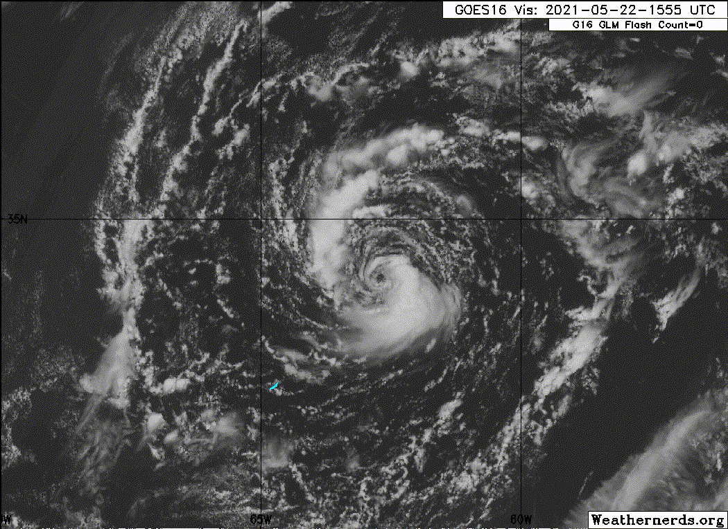
Re: ATL: ANA - Subtropical Storm - Discussion
And here's a nice satellite image as well, good morning Ana indeed.

6 likes
-
Sciencerocks
- Category 5
- Posts: 10186
- Age: 40
- Joined: Thu Jul 06, 2017 1:51 am
Re: ATL: ANA - Subtropical Storm - Discussion
The wind field and the focus of the convection is fairly "tight" to the center so any blow up could possibly transform this into a pure tropical cyclone but time is very limited.

6 likes
-
EquusStorm
- Category 5
- Posts: 1649
- Age: 35
- Joined: Thu Nov 07, 2013 1:04 pm
- Location: Jasper, AL
- Contact:
Re: ATL: ANA - Subtropical Storm - Discussion
It's lost that dense blob over the center it had last night but maintains some pretty standard wrapping convection for a subtropical system vastly better than yesterday; honestly expect another round of better convective organization tonight but that's the last chance it'll have to look good before it starts to feel hostile conditions. Neat to watch nevertheless.
0 likes
Colors of lost purpose on the canvas of irrelevance
Not a meteorologist, in fact more of an idiot than anything. You should probably check with the NHC or a local NWS office for official information.
Not a meteorologist, in fact more of an idiot than anything. You should probably check with the NHC or a local NWS office for official information.
-
captainbarbossa19

- Professional-Met

- Posts: 1094
- Age: 27
- Joined: Wed Aug 21, 2019 11:09 pm
- Location: Beaumont, TX
Re: ATL: ANA - Subtropical Storm - Discussion
EquusStorm wrote:Advisory's out, first Atlantic advisory of the year.
Of the past twenty seasons, only five have stayed entirely within the bounds of hurricane season. Wild.
True, but out of those 15 seasons, how many storms developed early and were only subtropical? Someone pointed out that we have only been naming subtropical storms since 2002 so the idea that we are having more early season activity is somewhat slanted. Other basins would have more early season activity too if they named subtropical storms. This is why I asked in a separate post if perhaps we should come up with a different system of classification for subtropical storms, since the main purpose of naming them is to provide alerts for maritime traffic.
2 likes
-
Yellow Evan

- Professional-Met
- Posts: 16240
- Age: 27
- Joined: Fri Jul 15, 2011 12:48 pm
- Location: Henderson, Nevada/Honolulu, HI
- Contact:
Re: ATL: ANA - Subtropical Storm - Discussion
This is one of the prettiest exposed systems I've seen.
6 likes
-
Sciencerocks
- Category 5
- Posts: 10186
- Age: 40
- Joined: Thu Jul 06, 2017 1:51 am
Re: ATL: ANA - Subtropical Storm - Discussion
This afternoon the outflow looks more anti-cyclonic. Probably not enough to change the characterization, but not far off.
0 likes
-
Sciencerocks
- Category 5
- Posts: 10186
- Age: 40
- Joined: Thu Jul 06, 2017 1:51 am

-
Sciencerocks
- Category 5
- Posts: 10186
- Age: 40
- Joined: Thu Jul 06, 2017 1:51 am


Re: ATL: ANA - Subtropical Storm - Discussion

The wrapping convection around a 'ring' plus earlier microwave data makes me think Ana has some sort of eyewall. It seems these mid latitude tcs are prone to developing eyes at lower intensities in even marginal conditions.
5 likes
Kendall -> SLO -> PBC
Memorable Storms: Katrina (for its Florida landfall...) Wilma Matthew Irma
Memorable Storms: Katrina (for its Florida landfall...) Wilma Matthew Irma
-
Stormybajan

- Category 1

- Posts: 453
- Joined: Thu May 20, 2021 3:21 pm
- Location: Windward Islands
Re: ATL: ANA - Subtropical Storm - Discussion
First post ever but based on the previous post above I would say Ana is indeed a TROPICAL storm given the amount of convection around the center
0 likes
Sad West Indies and Manchester United fan ⚽️
Who is online
Users browsing this forum: No registered users and 44 guests