2021 Indicators: SST's / SAL / MSLP / Shear / Steering / Instability / Sat Images

This is the general tropical discussion area. Anyone can take their shot at predicting a storms path.

Moderator: S2k Moderators

Forum rules

The posts in this forum are NOT official forecasts and should not be used as such. They are just the opinion of the poster and may or may not be backed by sound meteorological data. They are NOT endorsed by any professional institution or STORM2K. For official information, please refer to products from the National Hurricane Center and National Weather Service.

Help Support Storm2K
Message
Author
USTropics
Category 5
Category 5
Posts: 2635
Joined: Sun Aug 12, 2007 3:45 am
Location: Florida State University

Re: 2021 Indicators: SST's / SAL / MSLP / Shear / Steering / Instability / Sat Images

#561 Postby USTropics » Wed May 26, 2021 12:08 am

Also the notion the MDR is cooling is simply false if we're going by simply sea surface skins:

Image

This is reflected in the 7-day SST trend animation below:
Image

Depending on which data set you're using, we're slightly above or below the climo average baseline in the MDR:

Image

Image

We are starting at a lower base compared to hyperactive years at this point, so those type of strong MDR signals are not present currently. This is not an unfavorable look either, so to say the season will bust based on the current SST configuration would be premature.
10 likes   

USTropics
Category 5
Category 5
Posts: 2635
Joined: Sun Aug 12, 2007 3:45 am
Location: Florida State University

Re: 2021 Indicators: SST's / SAL / MSLP / Shear / Steering / Instability / Sat Images

#562 Postby USTropics » Wed May 26, 2021 3:30 am

This was from 2020, but is just as important for this year:

 https://twitter.com/philklotzbach/status/1266107330417979392


3 likes   

Shell Mound
Category 5
Category 5
Posts: 2434
Age: 32
Joined: Thu Sep 07, 2017 3:39 pm
Location: St. Petersburg, FL → Scandinavia

Re: 2021 Indicators: SST's / SAL / MSLP / Shear / Steering / Instability / Sat Images

#563 Postby Shell Mound » Wed May 26, 2021 3:56 am

USTropics wrote:This was from 2020, but is just as important for this year:

https://twitter.com/philklotzbach/status/1266107330417979392

Image
Image
Image

Overall, based on monthly OISSTv2 data to date (image at middle), there seems to be a weakly positive signal for enhanced activity, but not to the degree that CSU is forecasting. The SST gradient is more zonal than meridional so far, befitting EOF2 +AMO (image at bottom). That is why I think a slightly-above-average season with ACE of ~120 or so is more likely than a season with ACE ≥ 150, given that the EOF2 signature is taking its time to transition to EOF1. A similar situation, if I recall, existed in 2019 and the EOF2 +AMO never completed its transition to EOF1 +AMO by ASO.
0 likes   
CVW / MiamiensisWx / Shell Mound
The posts in this forum are NOT official forecasts and should not be used as such. They are just the opinion of the poster and may or may not be backed by sound meteorological data. They are NOT endorsed by any professional institution or STORM2K. For official information, please refer to products from the NHC and NWS.

User avatar
toad strangler
S2K Supporter
S2K Supporter
Posts: 4543
Joined: Sun Jul 28, 2013 3:09 pm
Location: Earth
Contact:

Re: 2021 Indicators: SST's / SAL / MSLP / Shear / Steering / Instability / Sat Images

#564 Postby toad strangler » Wed May 26, 2021 6:38 am

USTropics wrote:Also the notion the MDR is cooling is simply false if we're going by simply sea surface skins:


Handwringing, just like with SAL. It's quite entertaining TBH. You would think the MDR has icebergs floating around in it. In reality, it's a tik off with 3 months to go.
10 likes   

User avatar
SFLcane
S2K Supporter
S2K Supporter
Posts: 10162
Age: 47
Joined: Sat Jun 05, 2010 1:44 pm
Location: Lake Worth Florida

Re: 2021 Indicators: SST's / SAL / MSLP / Shear / Steering / Instability / Sat Images

#565 Postby SFLcane » Wed May 26, 2021 8:08 am

Yeah we're running behind 2020 and 2017 but not as cool as say 2018. Seems reasonable to expect an active season but not hyperactive maybe.
0 likes   

User avatar
Category5Kaiju
Category 5
Category 5
Posts: 4051
Joined: Thu Dec 24, 2020 12:45 pm
Location: Seattle

Re: 2021 Indicators: SST's / SAL / MSLP / Shear / Steering / Instability / Sat Images

#566 Postby Category5Kaiju » Wed May 26, 2021 8:49 am

So maybe I think the important question here would be are there common distinguishing early indications of a to-be hyperactive season versus a to-be above average season and how 2021 fits into the hyperactive or above average comparisons. I am no expert on this and perhaps somebody else may have better ideas on this, but I do wonder if there are any early tangible indicators common and unique to all hyperactive seasons...
0 likes   
Unless explicitly stated, all info in my posts is based on my own opinions and observations. Tropical storms and hurricanes can be extremely dangerous. Do not think you can beat Mother Nature. Refer to an accredited weather research agency or meteorologist if you need to make serious decisions regarding an approaching storm.

User avatar
toad strangler
S2K Supporter
S2K Supporter
Posts: 4543
Joined: Sun Jul 28, 2013 3:09 pm
Location: Earth
Contact:

Re: 2021 Indicators: SST's / SAL / MSLP / Shear / Steering / Instability / Sat Images

#567 Postby toad strangler » Wed May 26, 2021 9:02 am

SFLcane wrote:Yeah we're running behind 2020 and 2017 but not as cool as say 2018. Seems reasonable to expect an active season but not hyperactive maybe.


Whatever storms are going to form are going to form regardless if SST's are a hair or two below "normal". So perhaps ACE could be effected but I don't buy for a second that storms just won't appear because SST's are a bit off. If this season come in under projection it will be for multiple reasons above and beyond SST's
1 likes   

User avatar
SFLcane
S2K Supporter
S2K Supporter
Posts: 10162
Age: 47
Joined: Sat Jun 05, 2010 1:44 pm
Location: Lake Worth Florida

Re: 2021 Indicators: SST's / SAL / MSLP / Shear / Steering / Instability / Sat Images

#568 Postby SFLcane » Wed May 26, 2021 9:28 am

toad strangler wrote:
SFLcane wrote:Yeah we're running behind 2020 and 2017 but not as cool as say 2018. Seems reasonable to expect an active season but not hyperactive maybe.


Whatever storms are going to form are going to form regardless if SST's are a hair or two below "normal". So perhaps ACE could be effected but I don't buy for a second that storms just won't appear because SST's are a bit off. If this season come in under projection it will be for multiple reasons above and beyond SST's


Yeah although SST affects stability too. That's gonna hinder the season until ~August probably.
1 likes   

User avatar
Category5Kaiju
Category 5
Category 5
Posts: 4051
Joined: Thu Dec 24, 2020 12:45 pm
Location: Seattle

Re: 2021 Indicators: SST's / SAL / MSLP / Shear / Steering / Instability / Sat Images

#569 Postby Category5Kaiju » Wed May 26, 2021 9:47 am

If I am not mistaken last year was in a way hindered until August too, like we did not get out first major hurricane until the end of August and I specifically recall people yelling "season cancelled" in July and early August because they thought the SAL would ruin the entire season. Heck, 2017-2019 were also in a way hindered until August once Harvey, Florence, and Dorian occurred. So my overall point is, if we simple were to look at sst anomalies as the deciding factor in this season's activity (it isn't, but just as a theoretical thought process), assuming there indeed is a gradual warmup until the ASO timeframe, this season if anything could be a backloaded one. Sure, we may not get major July hurricanes, but how many seasons in the recent past have featured this anyways (we get it 2005, you were just going crazy back then :D )?

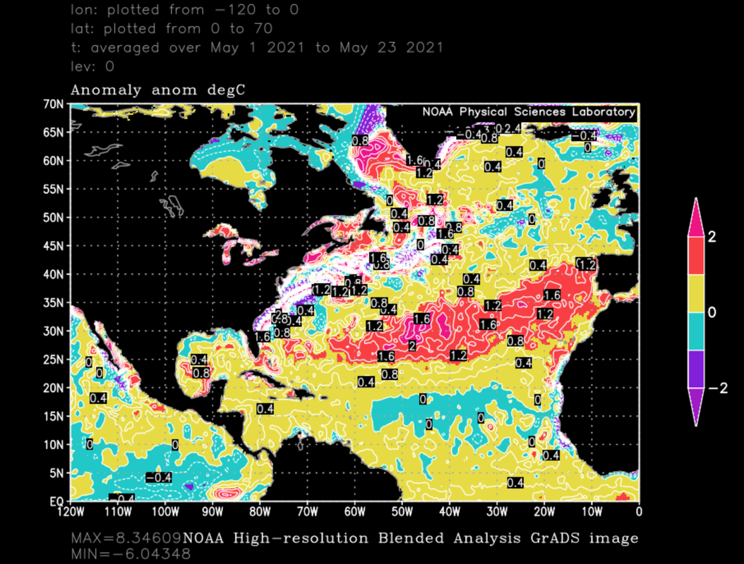
An additional point I would like to make is if I am also not mistaken, 2020 may have had warmer sst anomalies than 2021, but one thing I believe is working in 2021's favor is that the SAL is not as potent and extensive as it was at this point in time last year.
9 likes   
Unless explicitly stated, all info in my posts is based on my own opinions and observations. Tropical storms and hurricanes can be extremely dangerous. Do not think you can beat Mother Nature. Refer to an accredited weather research agency or meteorologist if you need to make serious decisions regarding an approaching storm.

tolakram
Admin
Admin
Posts: 19990
Age: 61
Joined: Sun Aug 27, 2006 8:23 pm
Location: Florence, KY (name is Mark)

Re: 2021 Indicators: SST's / SAL / MSLP / Shear / Steering / Instability / Sat Images

#570 Postby tolakram » Wed May 26, 2021 7:08 pm

I've had to move some useless posts into the moderation room. Please, it's not ok to make fun of others just because you don't like an opinion. If you replied to one of these your post is probably gone as well. Don't worry, but it's a good time for this friendly reminder:

If you have an issue with a post and think it violates S2K rules report it. Yes, every year we go through the same thing with SST's and SAL and no storms until August, and season cancel. It's all part of the conversation, and is only a problem if it's obviously trolling.

Thanks.
2 likes   
M a r k
- - - - -
Join us in chat: Storm2K Chatroom Invite. Android and IOS apps also available.

The posts in this forum are NOT official forecasts and should not be used as such. Posts are NOT endorsed by any professional institution or STORM2K.org. For official information and forecasts, please refer to NHC and NWS products.

User avatar
toad strangler
S2K Supporter
S2K Supporter
Posts: 4543
Joined: Sun Jul 28, 2013 3:09 pm
Location: Earth
Contact:

Re: 2021 Indicators: SST's / SAL / MSLP / Shear / Steering / Instability / Sat Images

#571 Postby toad strangler » Thu May 27, 2021 1:25 pm

Ben Noll acknowledging the SST change in May over 2020 but doesn't say anything about it's significance. Which I don't think is much at this point. Again, these are anomalies and I just don't see anything about this signature that says anything other than the warmer anomalies are in the sub tropics. Meat of the season still nearly 2.5 months out from beginning. Something to keep an eye on for sure.
 http://twitter.com/BenNollWeather/status/1397945440809754634


1 likes   

User avatar
HurricaneEnzo
Category 2
Category 2
Posts: 739
Joined: Wed Mar 14, 2018 12:18 pm
Location: Newport, NC (Hurricane Alley)

Re: 2021 Indicators: SST's / SAL / MSLP / Shear / Steering / Instability / Sat Images

#572 Postby HurricaneEnzo » Thu May 27, 2021 1:56 pm

toad strangler wrote:Ben Noll acknowledging the SST change in May over 2020 but doesn't say anything about it's significance. Which I don't think is much at this point. Again, these are anomalies and I just don't see anything about this signature that says anything other than the warmer anomalies are in the sub tropics. Meat of the season still nearly 2.5 months out from beginning. Something to keep an eye on for sure.
http://twitter.com/BenNollWeather/status/1397945440809754634?s=20


Looking at the map he is using I honestly don't see any massive differences. Yes the MDR is slightly cooler and Sub-tropics slightly warmer but I wouldn't say it is an absurd level of difference. I would say the EPAC looks better for Atlantic activity than 2020 as it is cooler over a larger area. Yeah last year overall might be a little better look but I don't see anything that looks like much of a deterrent for this season as it currently stands (strictly looking at SSTs). Still think we are looking at an active season just not 30 named storms active.
Last edited by HurricaneEnzo on Fri May 28, 2021 9:32 am, edited 1 time in total.
1 likes   
Bertha 96' - Fran 96' - Bonnie 98' - Dennis 99' - Floyd 99' - Isabel 03' - Alex 04' - Ophelia 05' - Irene 11' - Arthur 14' - Matthew 16' - Florence 18' - Dorian 19' - Isaias 20' (countless other tropical storms and Hurricane swipes)

I am not a Professional Met just an enthusiast. Get your weather forecasts from the Pros!

Shell Mound
Category 5
Category 5
Posts: 2434
Age: 32
Joined: Thu Sep 07, 2017 3:39 pm
Location: St. Petersburg, FL → Scandinavia

Re: 2021 Indicators: SST's / SAL / MSLP / Shear / Steering / Instability / Sat Images

#573 Postby Shell Mound » Fri May 28, 2021 2:59 am

With the MJO entering a low amplitude in Phase 7/8 over the next few weeks, this should be and already is promoting prolonged low-level westerlies over the MDR. Seven-day CDAS trends are finally showing substantial warming setting in over the past few days, just as the 850-mb westerlies (U-anomalies or zonal winds) have begun to kick in on the Hovmöller diagram(s). More importantly, the mid-latitude or subtropical Atlantic has been steadily cooling over the past week and a half, which supports further warming over the MDR, in line with CFSv2 forecasts for early June. Given the increasing likelihood of cool neutral ENSO persisting through ASO, with the warmest anomalies being concentrated near the IDL vs. Niño 1+2, I think I am finally beginning to sign onto the likelihood of a potentially hyperactive season, and have adjusted my seasonal forecast accordingly. A busy Atlantic season looks more and more likely.

Image

On another note, some forecasters are already “sounding the alarm” about 2021 possibly being to peninsular Florida what 2020 was to Louisiana:

But a shift in upper-air patterns over the United States has one leading meteorologist concerned the Bermuda-Azores high will forsake its 2020 stronghold in the western Atlantic – a move that could leave Florida more vulnerable to a tropical attack from the east.

Dan Kottlowski, a senior hurricane forecaster at the Pennsylvania-based AccuWeather...

“The Bermuda High will still nose into the Gulf of Mexico but we don’t think it will do it nearly as frequently,” Kottlowski said. “All we’re saying is that it's a more dangerous pattern for the East Coast.” ...

...National Hurricane Center Director Ken Graham said he is concerned Florida’s reputation as being stormproof last year may lead to a false sense of security.

He has been questioned enough about the lack of tropical cyclones hitting Florida that he made a graphic to show how the state would have faired had the Bermuda High been more to the east, similar to what AccuWeather is predicting.

Image

Instead of Louisiana being in 2020's tropical crosshairs, it would have been Florida with storm landfalls or hurricane-force winds ripping into Panama City, Tampa, Miami and Jacksonville.

“If the community thinks it wasn’t too bad for us last year, well, it wouldn’t take much of a change for that to be very different,” Graham said during a May hurricane preparation meeting. “Think about the high pressure in the Atlantic moving east and then Florida is in the way.

Climate and weather modelers at the University of Miami's Rosenstiel School of Marine and Atmospheric Science are studying the movement of the Bermuda High, including how it is reacting to the slowing of the Gulf Stream current in reaction to climate change. ...

UM professor Ben Kirtman said a slower Gulf Stream is correlating with a westerly movement of the Bermuda high that could mean more rain for the southeast United States.


More information:

“Florida got really lucky last year given how many storms were out there,” Klotzbach said. “But now the big concern is that one of these storms is going to actually hit a major metropolitan area and cause massive amounts of damage.

That’s especially the case for Tampa-St. Petersburg, which is so, so prone to storm surge.”
3 likes   
CVW / MiamiensisWx / Shell Mound
The posts in this forum are NOT official forecasts and should not be used as such. They are just the opinion of the poster and may or may not be backed by sound meteorological data. They are NOT endorsed by any professional institution or STORM2K. For official information, please refer to products from the NHC and NWS.

User avatar
SFLcane
S2K Supporter
S2K Supporter
Posts: 10162
Age: 47
Joined: Sat Jun 05, 2010 1:44 pm
Location: Lake Worth Florida

Re: 2021 Indicators: SST's / SAL / MSLP / Shear / Steering / Instability / Sat Images

#574 Postby SFLcane » Sat May 29, 2021 4:29 pm

0 likes   

User avatar
DorkyMcDorkface
Category 3
Category 3
Posts: 820
Age: 27
Joined: Mon Sep 30, 2019 1:32 pm
Location: Mid-Atlantic

Re: 2021 Indicators: SST's / SAL / MSLP / Shear / Steering / Instability / Sat Images

#575 Postby DorkyMcDorkface » Sun May 30, 2021 1:37 pm

1 likes   
Please note the thougths expressed by this account are solely those of the user and are from a hobbyist perspective. For more comprehensive analysis, consult an actual professional meteorologist or meteorology agency.


Floyd 1999 | Isabel 2003 | Hanna 2008 | Irene 2011 | Sandy 2012 | Isaias 2020

User avatar
aspen
Category 5
Category 5
Posts: 8812
Joined: Sat Oct 12, 2019 7:10 pm
Location: Connecticut, USA

Re: 2021 Indicators: SST's / SAL / MSLP / Shear / Steering / Instability / Sat Images

#576 Postby aspen » Sun May 30, 2021 2:44 pm

Took longer than anticipated, but the MDR is clearly warming up. While still a little cooler than normal, SSTs are indeed rising, and the 7-day anomaly change map shows warming throughout much of the MDR, Caribbean, and Gulf.
Image
Image
Image
4 likes   
Irene '11 Sandy '12 Hermine '16 5/15/2018 Derecho Fay '20 Isaias '20 Elsa '21 Henri '21 Ida '21

I am only a meteorology enthusiast who knows a decent amount about tropical cyclones. Look to the professional mets, the NHC, or your local weather office for the best information.

User avatar
cycloneye
Admin
Admin
Posts: 143865
Age: 68
Joined: Thu Oct 10, 2002 10:54 am
Location: San Juan, Puerto Rico

Re: 2021 Indicators: SST's / SAL / MSLP / Shear / Steering / Instability / Sat Images

#577 Postby cycloneye » Mon May 31, 2021 9:17 am

0 likes   
Visit the Caribbean-Central America Weather Thread where you can find at first post web cams,radars
and observations from Caribbean basin members Click Here

User avatar
JetFuel_SE
Category 1
Category 1
Posts: 280
Age: 25
Joined: Thu Apr 30, 2020 3:57 pm

Re: 2021 Indicators: SST's / SAL / MSLP / Shear / Steering / Instability / Sat Images

#578 Postby JetFuel_SE » Mon May 31, 2021 9:23 am

aspen wrote:Took longer than anticipated, but the MDR is clearly warming up. While still a little cooler than normal, SSTs are indeed rising, and the 7-day anomaly change map shows warming throughout much of the MDR, Caribbean, and Gulf.
https://i.imgur.com/z3Gq6dG.png
https://i.imgur.com/CEt7ivP.png
https://i.imgur.com/XNL8XRo.png

It's not really colder than average, CDAS has a cold bias, at least in the MDR.
0 likes   

User avatar
toad strangler
S2K Supporter
S2K Supporter
Posts: 4543
Joined: Sun Jul 28, 2013 3:09 pm
Location: Earth
Contact:

Re: 2021 Indicators: SST's / SAL / MSLP / Shear / Steering / Instability / Sat Images

#579 Postby toad strangler » Mon May 31, 2021 9:31 am

JetFuel_SE wrote:
aspen wrote:Took longer than anticipated, but the MDR is clearly warming up. While still a little cooler than normal, SSTs are indeed rising, and the 7-day anomaly change map shows warming throughout much of the MDR, Caribbean, and Gulf.
https://i.imgur.com/z3Gq6dG.png
https://i.imgur.com/CEt7ivP.png
https://i.imgur.com/XNL8XRo.png

It's not really colder than average, CDAS has a cold bias, at least in the MDR.


And it didn't take longer than anticipated either. There is next to nothing amiss with MDR SST's in relation to average. There hasn't been. I think people get fooled by the negative blue colors of a anomaly map and react like it's far too cool when temps are just off by fractions in reality.
5 likes   

User avatar
SFLcane
S2K Supporter
S2K Supporter
Posts: 10162
Age: 47
Joined: Sat Jun 05, 2010 1:44 pm
Location: Lake Worth Florida

Re: 2021 Indicators: SST's / SAL / MSLP / Shear / Steering / Instability / Sat Images

#580 Postby SFLcane » Mon May 31, 2021 10:09 am

It would be an interesting dig to look up ridges and front maps from late May in 2004. Florida’s rainy season started on the late side. Interested to look up NWS Miami AFDs from late May in 2004. Obviously nothing scientific in nature but definitely some similarities.
0 likes   


Return to “Talkin' Tropics”

Who is online

Users browsing this forum: No registered users and 967 guests