2021 Indicators: SST's / SAL / MSLP / Shear / Steering / Instability / Sat Images
Moderator: S2k Moderators
Forum rules

The posts in this forum are NOT official forecasts and should not be used as such. They are just the opinion of the poster and may or may not be backed by sound meteorological data. They are NOT endorsed by any professional institution or STORM2K. For official information, please refer to products from the National Hurricane Center and National Weather Service.
-
captainbarbossa19

- Professional-Met

- Posts: 1094
- Age: 27
- Joined: Wed Aug 21, 2019 11:09 pm
- Location: Beaumont, TX
Re: 2021 Indicators: SST's / SAL / MSLP / Shear / Steering / Instability / Sat Images
How many times must we go through this? Looking at the current SST Atlantic configuration and trying to predict its peak season configuration is like trying to tell me what the weather will be in 5 years at a specific spot. Didn't we all learn this the hard way a few years ago? Seems to me many said that the configuration would be a problem a few years ago and yet somehow, the SST managed to rebound in the tropical Atlantic and became one of the warmest spots at peak season. We do not know what is going to happen. There may be some similar analog years that we can look at, but it is honestly way too early to know what will transpire at peak season now. Also, let's not start on the SAL either. We have seen years when SAL was very thick early and still managed to have a hyperactive season. We have also seen SAL with rather thin levels and hyperactive seasons. Let us see what will happen and stop trying to correlate one or two events as the direct link to seasonal activity. 
8 likes

Re: 2021 Indicators: SST's / SAL / MSLP / Shear / Steering / Instability / Sat Images
captainbarbossa19 wrote:How many times must we go through this? Looking at the current SST Atlantic configuration and trying to predict its peak season configuration is like trying to tell me what the weather will be in 5 years at a specific spot. Didn't we all learn this the hard way a few years ago? Seems to me many said that the configuration would be a problem a few years ago and yet somehow, the SST managed to rebound in the tropical Atlantic and became one of the warmest spots at peak season. We do not know what is going to happen. There may be some similar analog years that we can look at, but it is honestly way too early to know what will transpire at peak season now. Also, let's not start on the SAL either. We have seen years when SAL was very thick early and still managed to have a hyperactive season. We have also seen SAL with rather thin levels and hyperactive seasons. Let us see what will happen and stop trying to correlate one or two events as the direct link to seasonal activity.
Well said. I made a post similar to this a few days ago but then deleted it lol
2 likes
-
tolakram
- Admin

- Posts: 20186
- Age: 62
- Joined: Sun Aug 27, 2006 8:23 pm
- Location: Florence, KY (name is Mark)
Re: 2021 Indicators: SST's / SAL / MSLP / Shear / Steering / Instability / Sat Images
captainbarbossa19 wrote:How many times must we go through this? Looking at the current SST Atlantic configuration and trying to predict its peak season configuration is like trying to tell me what the weather will be in 5 years at a specific spot. Didn't we all learn this the hard way a few years ago? Seems to me many said that the configuration would be a problem a few years ago and yet somehow, the SST managed to rebound in the tropical Atlantic and became one of the warmest spots at peak season. We do not know what is going to happen. There may be some similar analog years that we can look at, but it is honestly way too early to know what will transpire at peak season now. Also, let's not start on the SAL either. We have seen years when SAL was very thick early and still managed to have a hyperactive season. We have also seen SAL with rather thin levels and hyperactive seasons. Let us see what will happen and stop trying to correlate one or two events as the direct link to seasonal activity.
It's the indicators thread, we discuss indicators.
Look, I have to do the same thing every year. People in global model threads say don't look too far out. People in storm model threads say don't pay attention to the models until there's a center. It get's old. I feel like posts such as this (sorry to pick on you, this isn't unique) are attempting to shutdown conversation and I don't like it. We're in a thread to discuss indicators.
10 likes
M a r k
- - - - -
Join us in chat: Storm2K Chatroom Invite. Android and IOS apps also available.
The posts in this forum are NOT official forecasts and should not be used as such. Posts are NOT endorsed by any professional institution or STORM2K.org. For official information and forecasts, please refer to NHC and NWS products.
-
Category5Kaiju

- Category 5

- Posts: 4336
- Joined: Thu Dec 24, 2020 12:45 pm
- Location: Seattle during the summer, Phoenix during the winter
Re: 2021 Indicators: SST's / SAL / MSLP / Shear / Steering / Instability / Sat Images
Don't look at the 6z GFS from today 
0 likes
Unless explicitly stated, all information in my posts is based on my own opinions and observations. Tropical storms and hurricanes can be extremely dangerous. Refer to an accredited weather research agency or meteorologist if you need to make serious decisions regarding an approaching storm.
-
BYG Jacob
Re: 2021 Indicators: SST's / SAL / MSLP / Shear / Steering / Instability / Sat Images
Looks like we're in for a long and busy year based on the indicators so far, it won't be as busy and hellish as last year (knock on wood), but I'd say we're on track for a 15-20 6-9 2-4 kind of year.
0 likes
-
Shell Mound
- Category 5
- Posts: 2432
- Age: 33
- Joined: Thu Sep 07, 2017 3:39 pm
- Location: St. Petersburg, FL → Scandinavia
Re: 2021 Indicators: SST's / SAL / MSLP / Shear / Steering / Instability / Sat Images
https://twitter.com/WxTca/status/1401199864550154246
https://twitter.com/SteveBowenWx/status/1401875565481709572
https://twitter.com/antmasiello/status/1401885444787388420
https://twitter.com/SimonLeeWx/status/1401579646144192513
https://twitter.com/SteveBowenWx/status/1401875565481709572
https://twitter.com/antmasiello/status/1401885444787388420
https://twitter.com/SimonLeeWx/status/1401579646144192513
Last edited by Shell Mound on Mon Jun 07, 2021 9:10 am, edited 1 time in total.
0 likes
CVW / MiamiensisWx / Shell Mound
The posts in this forum are NOT official forecasts and should not be used as such. They are just the opinion of the poster and may or may not be backed by sound meteorological data. They are NOT endorsed by any professional institution or STORM2K. For official information, please refer to products from the NHC and NWS.

Re: 2021 Indicators: SST's / SAL / MSLP / Shear / Steering / Instability / Sat Images
Shell Mound wrote:https://twitter.com/WxTca/status/1401199864550154246
A further south ITCZ helps explain the Euro’s above-average ACE estimate, which is very high for the Euro. This would keep AEWs from being too north that they develop over cooler water and end up struggling like last year, so a southern ITCZ could lead to more long-trackers and high ACE storms.
1 likes
Irene '11 Sandy '12 Hermine '16 5/15/2018 Derecho Fay '20 Isaias '20 Elsa '21 Henri '21 Ida '21
I am only a meteorology enthusiast who knows a decent amount about tropical cyclones. Look to the professional mets, the NHC, or your local weather office for the best information.
I am only a meteorology enthusiast who knows a decent amount about tropical cyclones. Look to the professional mets, the NHC, or your local weather office for the best information.
-
BYG Jacob
Re: 2021 Indicators: SST's / SAL / MSLP / Shear / Steering / Instability / Sat Images
aspen wrote:Shell Mound wrote:https://twitter.com/WxTca/status/1401199864550154246
A further south ITCZ helps explain the Euro’s above-average ACE estimate, which is very high for the Euro. This would keep AEWs from being too north that they develop over cooler water and end up struggling like last year, so a southern ITCZ could lead to more long-trackers and high ACE storms.
It also allows storms to get much farther west before turning north
0 likes
Re: 2021 Indicators: SST's / SAL / MSLP / Shear / Steering / Instability / Sat Images
BYG Jacob wrote:aspen wrote:Shell Mound wrote:https://twitter.com/WxTca/status/1401199864550154246
A further south ITCZ helps explain the Euro’s above-average ACE estimate, which is very high for the Euro. This would keep AEWs from being too north that they develop over cooler water and end up struggling like last year, so a southern ITCZ could lead to more long-trackers and high ACE storms.
It also allows storms to get much farther west before turning north
Definitely a concerning model forecast. How well has the Euro been in forecasting seasonal indicators? I’m asking this because it usually has a dry bias and has been awful with TCG for the last year and a half.
0 likes
Irene '11 Sandy '12 Hermine '16 5/15/2018 Derecho Fay '20 Isaias '20 Elsa '21 Henri '21 Ida '21
I am only a meteorology enthusiast who knows a decent amount about tropical cyclones. Look to the professional mets, the NHC, or your local weather office for the best information.
I am only a meteorology enthusiast who knows a decent amount about tropical cyclones. Look to the professional mets, the NHC, or your local weather office for the best information.
-
SFLcane

- S2K Supporter

- Posts: 10281
- Age: 48
- Joined: Sat Jun 05, 2010 1:44 pm
- Location: Lake Worth Florida
Re: 2021 Indicators: SST's / SAL / MSLP / Shear / Steering / Instability / Sat Images
Cant help but think the euro is way too dry on those maps bias in full affect.
1 likes
-
Hurricaneman

- Category 5
- Posts: 7404
- Age: 45
- Joined: Tue Aug 31, 2004 3:24 pm
- Location: central florida
Re: 2021 Indicators: SST's / SAL / MSLP / Shear / Steering / Instability / Sat Images
Shell Mound wrote:https://twitter.com/WxTca/status/1401199864550154246
This may be important as if the Euro is right with the ITCZ we have to watch for possible long track hurricanes
0 likes
-
Shell Mound
- Category 5
- Posts: 2432
- Age: 33
- Joined: Thu Sep 07, 2017 3:39 pm
- Location: St. Petersburg, FL → Scandinavia
Re: 2021 Indicators: SST's / SAL / MSLP / Shear / Steering / Instability / Sat Images
SFLcane wrote:New June Euro steering is out…Don’t look now Florida. Rather ominous
It’s dry bias though is ridiculous
https://i.postimg.cc/t4wrjkhM/3678-C3-E3-C1-AE-4-AED-9-F95-4644-D5-CEEBDC.jpg
https://i.postimg.cc/mgtdJJF9/F685505-B-BA53-4726-800-D-2-D9-EF0-D4-BCC0.jpg
That ridge is actually too far north for landfalls to occur along most of the U.S. East Coast, much less Florida. The EC’s precipitation outlook suggests OTS tracks:
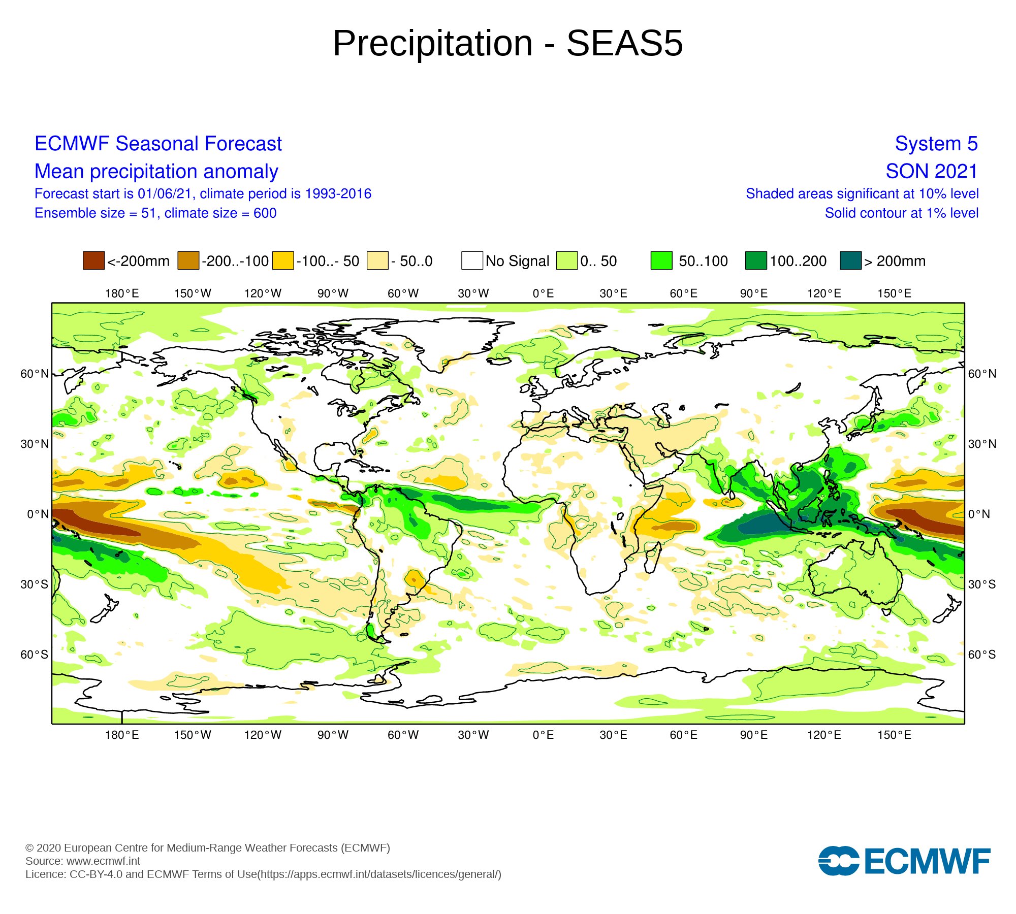
Note the pronounced dryness in the Gulf, over/near peninsular Florida, and just offshore of the Southeastern U.S. Most storms seem to curve over the subtropics.
0 likes
CVW / MiamiensisWx / Shell Mound
The posts in this forum are NOT official forecasts and should not be used as such. They are just the opinion of the poster and may or may not be backed by sound meteorological data. They are NOT endorsed by any professional institution or STORM2K. For official information, please refer to products from the NHC and NWS.
-
Loveweather12
- Tropical Storm

- Posts: 136
- Joined: Thu Aug 20, 2020 2:37 pm
Re: 2021 Indicators: SST's / SAL / MSLP / Shear / Steering / Instability / Sat Images
So are you saying that their won’t be landfalls this year? I’m a rookie in weather and just wanted to understand.
Shell Mound wrote:SFLcane wrote:New June Euro steering is out…Don’t look now Florida. Rather ominous
It’s dry bias though is ridiculous
https://i.postimg.cc/t4wrjkhM/3678-C3-E3-C1-AE-4-AED-9-F95-4644-D5-CEEBDC.jpg
https://i.postimg.cc/mgtdJJF9/F685505-B-BA53-4726-800-D-2-D9-EF0-D4-BCC0.jpg
That ridge is actually too far north for landfalls to occur along most of the U.S. East Coast, much less Florida. The EC’s precipitation outlook suggests OTS tracks:
https://pbs.twimg.com/media/E3IPryhWYAg-Z--?format=jpg&name=large
Note the pronounced dryness in the Gulf, over/near peninsular Florida, and just offshore of the Southeastern U.S. Most storms seem to curve over the subtropics.
0 likes
-
tolakram
- Admin
- Posts: 20186
- Age: 62
- Joined: Sun Aug 27, 2006 8:23 pm
- Location: Florence, KY (name is Mark)
Re: 2021 Indicators: SST's / SAL / MSLP / Shear / Steering / Instability / Sat Images
Shell Mound wrote:SFLcane wrote:New June Euro steering is out…Don’t look now Florida. Rather ominous
It’s dry bias though is ridiculous
https://i.postimg.cc/t4wrjkhM/3678-C3-E3-C1-AE-4-AED-9-F95-4644-D5-CEEBDC.jpg
https://i.postimg.cc/mgtdJJF9/F685505-B-BA53-4726-800-D-2-D9-EF0-D4-BCC0.jpg
That ridge is actually too far north for landfalls to occur along most of the U.S. East Coast, much less Florida. The EC’s precipitation outlook suggests OTS tracks:
https://pbs.twimg.com/media/E3IPryhWYAg-Z--?format=jpg&name=large
Note the pronounced dryness in the Gulf, over/near peninsular Florida, and just offshore of the Southeastern U.S. Most storms seem to curve over the subtropics.
That's a misreading of the long range forecast in my opinion. It's showing a ridging pattern but not exactly where it will set up. There is always at least a 95% chance (made up number, but a high chance) any storm will recurve before the coast in any year. The way I look at these is in identifying conditions that might indicate if these odds change at all. Maybe only a 93% chance of a recurve for example.
7 likes
M a r k
- - - - -
Join us in chat: Storm2K Chatroom Invite. Android and IOS apps also available.
The posts in this forum are NOT official forecasts and should not be used as such. Posts are NOT endorsed by any professional institution or STORM2K.org. For official information and forecasts, please refer to NHC and NWS products.
- - - - -
Join us in chat: Storm2K Chatroom Invite. Android and IOS apps also available.
The posts in this forum are NOT official forecasts and should not be used as such. Posts are NOT endorsed by any professional institution or STORM2K.org. For official information and forecasts, please refer to NHC and NWS products.
-
Category5Kaiju
- Category 5
- Posts: 4336
- Joined: Thu Dec 24, 2020 12:45 pm
- Location: Seattle during the summer, Phoenix during the winter
Re: 2021 Indicators: SST's / SAL / MSLP / Shear / Steering / Instability / Sat Images
Loveweather12 wrote:So are you saying that their won’t be landfalls this year? I’m a rookie in weather and just wanted to understand.Shell Mound wrote:SFLcane wrote:New June Euro steering is out…Don’t look now Florida. Rather ominous
It’s dry bias though is ridiculous
https://i.postimg.cc/t4wrjkhM/3678-C3-E3-C1-AE-4-AED-9-F95-4644-D5-CEEBDC.jpg
https://i.postimg.cc/mgtdJJF9/F685505-B-BA53-4726-800-D-2-D9-EF0-D4-BCC0.jpg
That ridge is actually too far north for landfalls to occur along most of the U.S. East Coast, much less Florida. The EC’s precipitation outlook suggests OTS tracks:
https://pbs.twimg.com/media/E3IPryhWYAg-Z--?format=jpg&name=large
Note the pronounced dryness in the Gulf, over/near peninsular Florida, and just offshore of the Southeastern U.S. Most storms seem to curve over the subtropics.
Well not exactly, this is one model run and things can change if another run was performed, and especially in wx there's a saying to not put too much faith in one model run. Rather, a consensus with many model runs done over a certain period of time is what is more important.
Also just because a pattern looks like it will support many OTS tracks does not mean it is going to make 100% of every storm that forms recurve. Remember 2019, for instance. That was a heavy recurve year unless you remember Dorian, which just happened to get trapped under a ridge of high pressure and enter the right conditions for disaster to strike. 2011 also, Irene.
Btw it's ok to be a rookie; welcome to the tropical wx community! I myself started tracking hurricanes in 2017, and while I am a biology major, tracking hurricanes and tropical weather has been and will always be my favorite hobby outside of the life science field that I am in!
8 likes
Unless explicitly stated, all information in my posts is based on my own opinions and observations. Tropical storms and hurricanes can be extremely dangerous. Refer to an accredited weather research agency or meteorologist if you need to make serious decisions regarding an approaching storm.
-
USTropics
- Professional-Met
- Posts: 2739
- Joined: Sun Aug 12, 2007 3:45 am
- Location: Florida State University
Re: 2021 Indicators: SST's / SAL / MSLP / Shear / Steering / Instability / Sat Images
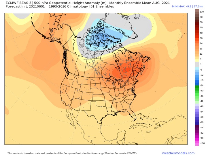
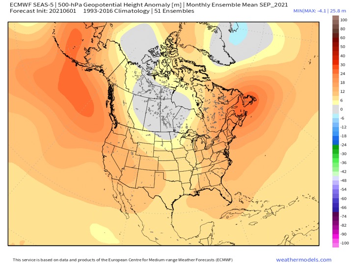
I would hesitate to use seasonal precipitation rate anomalies to forecast tropical system tracks, their signatures are not accurately depicted when we're using 3-month seasonal forecasts. I plotted the ECMWF June forecast for ASO from 2020 below and the actual observed precip anomalies observed during ASO from last year for verification. These are 1920x1080 so download them to zoom in:


7 likes

Re: 2021 Indicators: SST's / SAL / MSLP / Shear / Steering / Instability / Sat Images
tolakram wrote:Shell Mound wrote:SFLcane wrote:New June Euro steering is out…Don’t look now Florida. Rather ominous
It’s dry bias though is ridiculous
https://i.postimg.cc/t4wrjkhM/3678-C3-E3-C1-AE-4-AED-9-F95-4644-D5-CEEBDC.jpg
https://i.postimg.cc/mgtdJJF9/F685505-B-BA53-4726-800-D-2-D9-EF0-D4-BCC0.jpg
That ridge is actually too far north for landfalls to occur along most of the U.S. East Coast, much less Florida. The EC’s precipitation outlook suggests OTS tracks:
https://pbs.twimg.com/media/E3IPryhWYAg-Z--?format=jpg&name=large
Note the pronounced dryness in the Gulf, over/near peninsular Florida, and just offshore of the Southeastern U.S. Most storms seem to curve over the subtropics.
That's a misreading of the long range forecast in my opinion. It's showing a ridging pattern but not exactly where it will set up. There is always at least a 95% chance (made up number, but a high chance) any storm will recurve before the coast in any year. The way I look at these is in identifying conditions that might indicate if these odds change at all. Maybe only a 93% chance of a recurve for example.
Obviously one must view these and other indicators with proper perspective. Assuming that the Euro's August and September Height anomaly projections verify, I would agree that an eastward or southeast approaching tropical cyclone might pose an increased risk to the Bahamas, Florida, and North Gulf Coast (from Louisiana to the Fla Panhandle). I see this as a plausible solution primarily as a result of the suggested orientation of the forecast anomalous mid level ridging. Still, the specific dynamics for any given week during the season could have enough deviation where the greatest heights could also be a bit further east which then could result in a threat to the Mid-Atlantic. My take-away does not preclude that poleward recurving simply will not occur, but those that would recurve are more likely to represent a cluster of tracks that originate from further east and perhaps a bit further north of the normal MDR. On the other hand, those systems that develop near (or west of 60W) might be those that the suggested mean steering forecast might result in a ridge trapping pattern with a primarily westward track.
The Euro precip anomaly forecast offers much less insight as far as I'm concerned. First off, this is a "mean precip anomaly forecast" for September, October, and November. Two-thirds of this period largely take in climo periods where I wouldn't be even looking much east of the Lesser Antilles for potential threat. The map might imply an active but southward suppression of the ITCZ but all in all suggesting neutral conditions for the far W. Atlantic, Caribbean, and GOM. It certainly doesn't suggest recurrent development or storm tracks in the Caribbean, Gulf, or off the S.E. Seaboard...... but it also does not dismiss the one or two that might occur either.
Overall conditions for development notwithstanding, the few grains of salt that I "might" take away from all the above would be that August/early Sept might pose more threat to the Bahamas and S.E. CONUS then later Sept. or October development would. Again though, these are just a few grains of salt.
1 likes
Andy D
(For official information, please refer to the NHC and NWS products.)
(For official information, please refer to the NHC and NWS products.)
-
AutoPenalti
- Category 5
- Posts: 4091
- Age: 29
- Joined: Mon Aug 17, 2015 4:16 pm
- Location: Ft. Lauderdale, Florida
Re: 2021 Indicators: SST's / SAL / MSLP / Shear / Steering / Instability / Sat Images
Shellmound is anything but a rookie, definitely has insightful (and at times very confusing to understand) posts based on real-time analysis, of course when it comes down to forecasting into the future, it becomes increasingly ambitious to analyze the little details.
My biggest concern was the increased ACE of 130% from the normally quieter Euro, and the GoG pattern that can potential move the ITCZ further South.
Edit: After publishing this, I noticed that OP was mentioning another user, but still, it's very interesting the amount of detail he puts into the forecasts.
2 likes
The posts in this forum are NOT official forecasts and should not be used as such. They are just the opinion of the poster and may or may not be backed by sound meteorological data. They are NOT endorsed by any professional institution or STORM2K. For official information, please refer to products from the NHC and NWS.
Model Runs Cheat Sheet:
GFS (5:30 AM/PM, 11:30 AM/PM)
HWRF, GFDL, UKMET, NAVGEM (6:30-8:00 AM/PM, 12:30-2:00 AM/PM)
ECMWF (1:45 AM/PM)
TCVN is a weighted averaged
-
GrayLancer18

- Tropical Depression

- Posts: 88
- Joined: Mon Sep 02, 2019 2:45 pm
- Contact:
Re: 2021 Indicators: SST's / SAL / MSLP / Shear / Steering / Instability / Sat Images
3 likes
Hugo (1989) Hortense (1996) Georges (1998) Jeanne (2004) Irene (2011) Maria (2017)
I am NOT a professional meteorologist nor weather professional. Opinions are my own.
Consult with NHC and NOAA for official forecasts and advisories.
I am NOT a professional meteorologist nor weather professional. Opinions are my own.
Consult with NHC and NOAA for official forecasts and advisories.
-
USTropics
- Professional-Met
- Posts: 2739
- Joined: Sun Aug 12, 2007 3:45 am
- Location: Florida State University
Re: 2021 Indicators: SST's / SAL / MSLP / Shear / Steering / Instability / Sat Images
NMME June data just became available, here are the precipitation anomalies for ASO:

Compared to May forecast:

Compared to May forecast:
1 likes