
May forecast:

Moderator: S2k Moderators


USTropics wrote:NMME June Sea Surface Temperature Anomalies for ASO:
https://i.imgur.com/OmXsWZq.png
May forecast:
https://i.imgur.com/uaQkv5c.png


Shell Mound wrote:USTropics wrote:NMME June Sea Surface Temperature Anomalies for ASO:
https://i.imgur.com/OmXsWZq.png
May forecast:
https://i.imgur.com/uaQkv5c.png
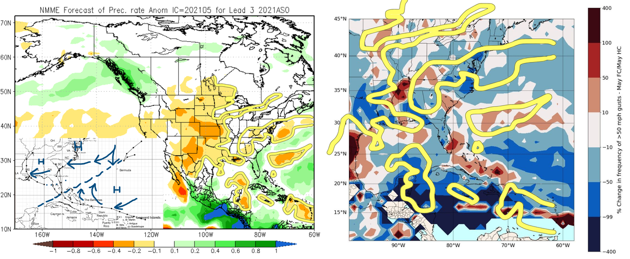
Interestingly, the June forecast suggests a transition toward a blend of EOF1/2 +AMO. Note that the subtropical warm tongue north of the MDR is projected to cool down relative to the MDR, which concomitantly shows signs of warming. Overall, the +AMO looks stronger on the June vs. the May NMME. Also notable is the fact that the ITCZ, while suppressed, is wetter on the most recent run, which also shows a stronger east-based -ENSO signature, with rising air tending to concentrate a bit more over the MC, with sinking air more solidly established over the C/EPAC. This, along with the +AMO trend and a more southerly ITCZ (implying a somewhat weaker African monsoon) vs. 2020, would definitely favour somewhat higher odds of a hyperactive Atlantic season, given the odds of a more active MDR vs. 2020. What’s more disconcerting is that the June NMME has also trended toward a wetter Southeastern U.S., particularly the Florida peninsula, along with a wetter Caribbean vs. the May NMME. This could suggest that both South-Central Florida and the eastern GoM as well as Central America + Yucatán could be at higher-than-normal risk during peak season. The likelihood of elongated, expansive Western Atlantic Ridging (WAR) on the most recent NMME could suggest long-trackers similar to Irma, Georges (1998), or the 1926 Miami/1947 Fort Lauderdale hurricanes, possibly tracking WNW through the Bahamas into Miami/Fort Lauderdale before heading NW toward SE LA (MS River Delta)/MS/AL/western FL Panhandle.
USTropics wrote:NMME June Sea Surface Temperature Anomalies for ASO:
https://i.imgur.com/OmXsWZq.png
May forecast:
https://i.imgur.com/uaQkv5c.png


Kingarabian wrote:Don't forget guys:
https://twitter.com/WxTca/status/1401923723087822858/photo/3
DorkyMcDorkface wrote:Kingarabian wrote:Don't forget guys:
https://twitter.com/WxTca/status/1401923723087822858/photo/3
Even then though the overall consensus seems to be -ENSO by ASO, albeit cool-neutral and not so much La Niña.
SFLcane wrote:Shell Mound wrote:USTropics wrote:NMME June Sea Surface Temperature Anomalies for ASO:
https://i.imgur.com/OmXsWZq.png
May forecast:
https://i.imgur.com/uaQkv5c.png
Interestingly, the June forecast suggests a transition toward a blend of EOF1/2 +AMO. Note that the subtropical warm tongue north of the MDR is projected to cool down relative to the MDR, which concomitantly shows signs of warming. Overall, the +AMO looks stronger on the June vs. the May NMME. Also notable is the fact that the ITCZ, while suppressed, is wetter on the most recent run, which also shows a stronger east-based -ENSO signature, with rising air tending to concentrate a bit more over the MC, with sinking air more solidly established over the C/EPAC. This, along with the +AMO trend and a more southerly ITCZ (implying a somewhat weaker African monsoon) vs. 2020, would definitely favour somewhat higher odds of a hyperactive Atlantic season, given the odds of a more active MDR vs. 2020. What’s more disconcerting is that the June NMME has also trended toward a wetter Southeastern U.S., particularly the Florida peninsula, along with a wetter Caribbean vs. the May NMME. This could suggest that both South-Central Florida and the eastern GoM as well as Central America + Yucatán could be at higher-than-normal risk during peak season. The likelihood of elongated, expansive Western Atlantic Ridging (WAR) on the most recent NMME could suggest long-trackers similar to Irma, Georges (1998), or the 1926 Miami/1947 Fort Lauderdale hurricanes, possibly tracking WNW through the Bahamas into Miami/Fort Lauderdale before heading NW toward SE LA (MS River Delta)/MS/AL/western FL Panhandle.
This is not a strong signal by any means over Florida.


cycloneye wrote:https://twitter.com/BenNollWeather/status/1402257856494190601

NDG wrote:I don't like the trends by the NMME for us here in FL.
https://twitter.com/BenNollWeather/status/1402272956315803651?s=20

Users browsing this forum: Old-TimeCane, Ulf, wwizard and 254 guests
