2021 EPAC Season

This is the general tropical discussion area. Anyone can take their shot at predicting a storms path.

Moderator: S2k Moderators

Forum rules

The posts in this forum are NOT official forecasts and should not be used as such. They are just the opinion of the poster and may or may not be backed by sound meteorological data. They are NOT endorsed by any professional institution or STORM2K. For official information, please refer to products from the National Hurricane Center and National Weather Service.

Help Support Storm2K
Message
Author
User avatar
Kingarabian
S2K Supporter
S2K Supporter
Posts: 15980
Joined: Sat Aug 08, 2009 3:06 am
Location: Honolulu, Hawaii

Re: 2021 EPAC Season

#281 Postby Kingarabian » Wed Jun 09, 2021 5:51 pm

UKMET has been on and off but more bullish compared to the past three invests:
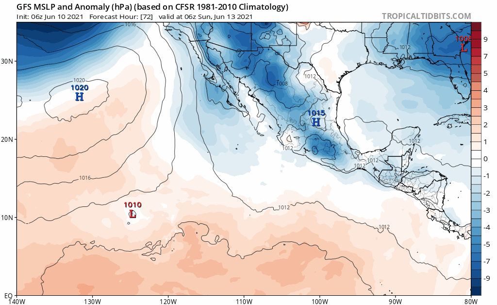
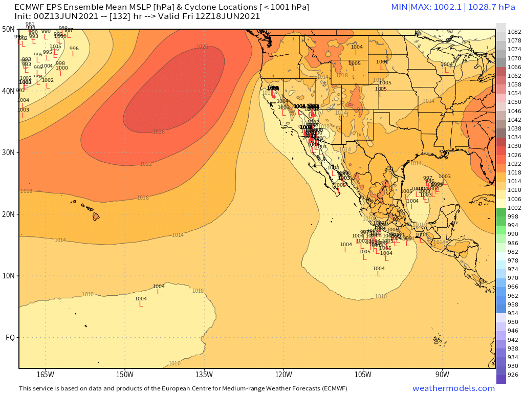
NEW TROPICAL CYCLONE FORECAST TO DEVELOP AFTER 114 HOURS
FORECAST POSITION AT T+114 : 13.9N 94.7W

LEAD CENTRAL MAXIMUM WIND
VERIFYING TIME TIME POSITION PRESSURE (MB) SPEED (KNOTS)
-------------- ---- -------- ------------- -------------
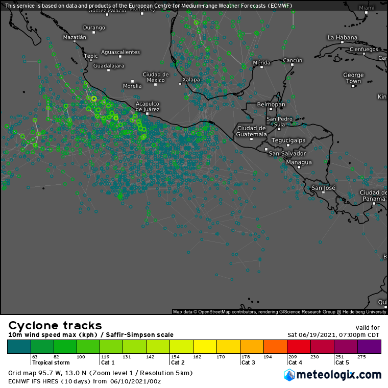
1200UTC 14.06.2021 120 14.1N 95.2W 1004 30
0000UTC 15.06.2021 132 14.5N 94.5W 1002 34
1200UTC 15.06.2021 144 15.8N 94.7W 999 45
0 likes   
RIP Kobe Bryant

User avatar
Yellow Evan
Professional-Met
Professional-Met
Posts: 16143
Age: 27
Joined: Fri Jul 15, 2011 12:48 pm
Location: Henderson, Nevada/Honolulu, HI
Contact:

Re: 2021 EPAC Season

#282 Postby Yellow Evan » Wed Jun 09, 2021 6:19 pm

Image

Image

Image

Image

Likely convective feedback but 18z GFS slams a potent hurricane into Nayarit.
0 likes   

User avatar
cycloneye
Admin
Admin
Posts: 145292
Age: 68
Joined: Thu Oct 10, 2002 10:54 am
Location: San Juan, Puerto Rico

Re: 2021 EPAC Season

#283 Postby cycloneye » Wed Jun 09, 2021 6:45 pm

Tropical Weather Outlook
NWS National Hurricane Center Miami FL
500 PM PDT Wed Jun 9 2021

For the eastern North Pacific...east of 140 degrees west longitude:

1. A broad area of low pressure is expected to form a couple of hundred
miles south of the coasts of southern Mexico and Guatemala during
the next day or two. Environmental conditions appear favorable for
some gradual development thereafter, and a tropical depression could
form this weekend while the system drifts generally northward.
Regardless of development, heavy rainfall could occur over portions
of Central America and southern Mexico late this week and into the
weekend. See products from your local meteorological service for
more information.
* Formation chance through 48 hours...low...near 0 percent.
* Formation chance through 5 days...medium...40 percent.

Forecaster Papin/Stewart
0 likes   
Visit the Caribbean-Central America Weather Thread where you can find at first post web cams,radars
and observations from Caribbean basin members Click Here

User avatar
Kingarabian
S2K Supporter
S2K Supporter
Posts: 15980
Joined: Sat Aug 08, 2009 3:06 am
Location: Honolulu, Hawaii

Re: 2021 EPAC Season

#284 Postby Kingarabian » Thu Jun 10, 2021 2:17 am

00z GFS continues to bring back 92E and continues to show a deep system off of Mexico.

00z Euro attempts to bring 92E and also shows the same system as the GFS off of Mexico.
0 likes   
RIP Kobe Bryant

User avatar
Yellow Evan
Professional-Met
Professional-Met
Posts: 16143
Age: 27
Joined: Fri Jul 15, 2011 12:48 pm
Location: Henderson, Nevada/Honolulu, HI
Contact:

Re: 2021 EPAC Season

#285 Postby Yellow Evan » Thu Jun 10, 2021 4:23 am

A broad trough of low pressure has formed several hundred miles
south of Salina Cruz, Mexico, and is producing a large area of
disorganized showers and thunderstorms. Environmental conditions
appear favorable for gradual development, and a tropical depression
could form this weekend or early next week while the system drifts
generally northward. Regardless of development, heavy rainfall
could occur over portions of Central America and southern Mexico
late this week and into early next week. See products from
your local meteorological service for more information.
* Formation chance through 48 hours...low...near 0 percent.
* Formation chance through 5 days...medium...40 percent.
0 likes   

User avatar
Kingarabian
S2K Supporter
S2K Supporter
Posts: 15980
Joined: Sat Aug 08, 2009 3:06 am
Location: Honolulu, Hawaii

Re: 2021 EPAC Season

#286 Postby Kingarabian » Thu Jun 10, 2021 5:10 am

Appears to be trough/large area of low pressure that comes off Baja California that dips and makes its way into the EPAC. This area will be accompanied with much weaker trades. So there's a good chance for the EPAC waters between 10N-20N to warm up further.
Image
0 likes   
RIP Kobe Bryant

JW-_-

Re: 2021 EPAC Season

#287 Postby JW-_- » Thu Jun 10, 2021 6:07 am

Image

Ens thinking is looking confident, we may see some further activity. Over the 10 days.
0 likes   

User avatar
cycloneye
Admin
Admin
Posts: 145292
Age: 68
Joined: Thu Oct 10, 2002 10:54 am
Location: San Juan, Puerto Rico

Re: 2021 EPAC Season

#288 Postby cycloneye » Thu Jun 10, 2021 7:08 am

Tropical Weather Outlook
NWS National Hurricane Center Miami FL
500 AM PDT Thu Jun 10 2021

For the eastern North Pacific...east of 140 degrees west longitude:

1. A broad trough of low pressure located several hundred miles south
of the coast of southern Mexico is producing a large area of
disorganized showers and thunderstorms. Environmental conditions
appear conducive for gradual development, and a tropical depression
could form this weekend or early next week while the system drifts
generally northward. Regardless of development, heavy rainfall
could occur over portions of Central America and southern Mexico
late this week and into early next week. See products from your
local meteorological service for more information.
* Formation chance through 48 hours...low...near 0 percent.
* Formation chance through 5 days...medium...40 percent.

2. A broad area of low pressure along the eastern Pacific monsoon
trough about 900 miles south-southwest of the southern tip of the
Baja California peninsula is producing a large area of disorganized
showers and thunderstorms. Some gradual development is possible
over the next few days as the system moves slowly westward.
* Formation chance through 48 hours...low...10 percent.
* Formation chance through 5 days...low...20 percent.

Forecaster Reinhart/Beven
0 likes   
Visit the Caribbean-Central America Weather Thread where you can find at first post web cams,radars
and observations from Caribbean basin members Click Here

User avatar
Yellow Evan
Professional-Met
Professional-Met
Posts: 16143
Age: 27
Joined: Fri Jul 15, 2011 12:48 pm
Location: Henderson, Nevada/Honolulu, HI
Contact:

Re: 2021 EPAC Season

#289 Postby Yellow Evan » Thu Jun 10, 2021 1:11 pm

Image

12z GFS no longer develops the 0/40 before landfall, just shows a hurricane into Jalisco/Nayarit.
0 likes   

User avatar
Yellow Evan
Professional-Met
Professional-Met
Posts: 16143
Age: 27
Joined: Fri Jul 15, 2011 12:48 pm
Location: Henderson, Nevada/Honolulu, HI
Contact:

Re: 2021 EPAC Season

#290 Postby Yellow Evan » Thu Jun 10, 2021 1:18 pm

Image

12z ECMWF through 72 hours now showing a 0/40 spinning up in the GOT.
0 likes   

User avatar
Kingarabian
S2K Supporter
S2K Supporter
Posts: 15980
Joined: Sat Aug 08, 2009 3:06 am
Location: Honolulu, Hawaii

Re: 2021 EPAC Season

#291 Postby Kingarabian » Thu Jun 10, 2021 3:24 pm

12z EPS looking pretty active for the next 10 days. The question is whether something will consolidate and become an actual TC.

Image
3 likes   
RIP Kobe Bryant

User avatar
Yellow Evan
Professional-Met
Professional-Met
Posts: 16143
Age: 27
Joined: Fri Jul 15, 2011 12:48 pm
Location: Henderson, Nevada/Honolulu, HI
Contact:

Re: 2021 EPAC Season

#292 Postby Yellow Evan » Fri Jun 11, 2021 3:02 pm

Image

12z GFS still has a broad tropical cyclone in 10 days,
0 likes   

User avatar
Yellow Evan
Professional-Met
Professional-Met
Posts: 16143
Age: 27
Joined: Fri Jul 15, 2011 12:48 pm
Location: Henderson, Nevada/Honolulu, HI
Contact:

Re: 2021 EPAC Season

#293 Postby Yellow Evan » Fri Jun 11, 2021 3:03 pm

12z ECMWF has nothing aside from 93E.
0 likes   

User avatar
Kingarabian
S2K Supporter
S2K Supporter
Posts: 15980
Joined: Sat Aug 08, 2009 3:06 am
Location: Honolulu, Hawaii

Re: 2021 EPAC Season

#294 Postby Kingarabian » Fri Jun 11, 2021 6:29 pm

18z GFS keeps the EPAC active through the next 16 days:
Image

Image
0 likes   
RIP Kobe Bryant

User avatar
Kingarabian
S2K Supporter
S2K Supporter
Posts: 15980
Joined: Sat Aug 08, 2009 3:06 am
Location: Honolulu, Hawaii

Re: 2021 EPAC Season

#295 Postby Kingarabian » Sat Jun 12, 2021 6:02 pm

Large area between 100W/110W might be the next invest tag:
Image

Model solutions are on and off on it, with any development likely delayed until it reaches and begins to rotate just off the Mexican coast.'

Has some EPS support:
Image

www.weathermodels.com
Last edited by Kingarabian on Sat Jun 12, 2021 6:53 pm, edited 1 time in total.
0 likes   
RIP Kobe Bryant

User avatar
Kingarabian
S2K Supporter
S2K Supporter
Posts: 15980
Joined: Sat Aug 08, 2009 3:06 am
Location: Honolulu, Hawaii

Re: 2021 EPAC Season

#296 Postby Kingarabian » Sat Jun 12, 2021 6:06 pm

Just by the amount of convection and the nature of the TC's that are forming or trying to form, I must say I am surprised. It's looking like mid August out there.
Image
3 likes   
RIP Kobe Bryant

User avatar
Kingarabian
S2K Supporter
S2K Supporter
Posts: 15980
Joined: Sat Aug 08, 2009 3:06 am
Location: Honolulu, Hawaii

Re: 2021 EPAC Season

#297 Postby Kingarabian » Sun Jun 13, 2021 4:05 am

Kingarabian wrote:Large area between 100W/110W might be the next invest tag:
[url]https://i.imgur.com/mPIKpLW.png[url]

Model solutions are on and off on it, with any development likely delayed until it reaches and begins to rotate just off the Mexican coast.'

Has some EPS support:
[url]https://i.imgur.com/NdNeKeb.png[url]

http://www.weathermodels.com


Pretty good support for the next AOI in the EPAC. Probably will be circled in a few more days:

Image

http://www.weathermodels.com
0 likes   
RIP Kobe Bryant

User avatar
cycloneye
Admin
Admin
Posts: 145292
Age: 68
Joined: Thu Oct 10, 2002 10:54 am
Location: San Juan, Puerto Rico

Re: 2021 EPAC Season

#298 Postby cycloneye » Sun Jun 13, 2021 12:46 pm

An area of low pressure is expected to form by late this week a
couple of hundred miles offshore of the coast of southwestern
Mexico. Some gradual development is possible thereafter as the
system moves slowly northwestward.
* Formation chance through 48 hours...low...near 0 percent.
* Formation chance through 5 days...low...20 percent.
0 likes   
Visit the Caribbean-Central America Weather Thread where you can find at first post web cams,radars
and observations from Caribbean basin members Click Here

User avatar
Yellow Evan
Professional-Met
Professional-Met
Posts: 16143
Age: 27
Joined: Fri Jul 15, 2011 12:48 pm
Location: Henderson, Nevada/Honolulu, HI
Contact:

Re: 2021 EPAC Season

#299 Postby Yellow Evan » Sun Jun 13, 2021 1:12 pm

Image

12z GFS brings this into Colima.
0 likes   

User avatar
Yellow Evan
Professional-Met
Professional-Met
Posts: 16143
Age: 27
Joined: Fri Jul 15, 2011 12:48 pm
Location: Henderson, Nevada/Honolulu, HI
Contact:

Re: 2021 EPAC Season

#300 Postby Yellow Evan » Sun Jun 13, 2021 7:18 pm

Image

18z GFS brings this into Michoacan.
0 likes   


Return to “Talkin' Tropics”

Who is online

Users browsing this forum: Ulf, USTropics and 42 guests