ATL: CLAUDETTE - Models
Moderator: S2k Moderators
-
cycloneye

- Admin

- Posts: 149550
- Age: 69
- Joined: Thu Oct 10, 2002 10:54 am
- Location: San Juan, Puerto Rico
ATL: CLAUDETTE - Models
Only model runs here.
0 likes
Visit the Caribbean-Central America Weather Thread where you can find at first post web cams,radars
and observations from Caribbean basin members Click Here
and observations from Caribbean basin members Click Here


-
cycloneye
- Admin
- Posts: 149550
- Age: 69
- Joined: Thu Oct 10, 2002 10:54 am
- Location: San Juan, Puerto Rico
Re: ATL: INVEST 92L - Models
GFS ensembles.

1 likes
Visit the Caribbean-Central America Weather Thread where you can find at first post web cams,radars
and observations from Caribbean basin members Click Here
and observations from Caribbean basin members Click Here

Re: ATL: INVEST 92L - Models
92L becomes a moderate TS in the 12z HWRF-P run for 93E, peaking on Monday night/Tuesday morning.
1 likes
Irene '11 Sandy '12 Hermine '16 5/15/2018 Derecho Fay '20 Isaias '20 Elsa '21 Henri '21 Ida '21
I am only a meteorology enthusiast who knows a decent amount about tropical cyclones. Look to the professional mets, the NHC, or your local weather office for the best information.
I am only a meteorology enthusiast who knows a decent amount about tropical cyclones. Look to the professional mets, the NHC, or your local weather office for the best information.
-
hurricane2025
- Category 1

- Posts: 254
- Joined: Thu Apr 08, 2021 10:36 am
-
captainbarbossa19

- Professional-Met

- Posts: 1094
- Age: 27
- Joined: Wed Aug 21, 2019 11:09 pm
- Location: Beaumont, TX
Re: ATL: INVEST 92L - Models
Did anyone see that the Euro is wanting to drop about 40 inches of rain in Central Louisiana from this system? That is really bad.
1 likes
-
Kingarabian

- S2K Supporter

- Posts: 16373
- Joined: Sat Aug 08, 2009 3:06 am
- Location: Honolulu, Hawaii
Re: ATL: INVEST 92L - Models
aspen wrote:92L becomes a moderate TS in the 12z HWRF-P run for 93E, peaking on Monday night/Tuesday morning.
Don't think systems on the HWRF-P are valid other than what the run is designated for. They can be very erroneous.
1 likes
RIP Kobe Bryant
-
Iceresistance

- Category 5

- Posts: 9598
- Age: 22
- Joined: Sat Oct 10, 2020 9:45 am
- Location: Tecumseh, OK/Norman, OK
Re: ATL: INVEST 92L - Models
captainbarbossa19 wrote:Did anyone see that the Euro is wanting to drop about 40 inches of rain in Central Louisiana from this system? That is really bad.
I did, can Louisiana get a break from this?
1 likes
Bill 2015 & Beta 2020
Winter 2020-2021
All observations are in Tecumseh, OK unless otherwise noted.
Winter posts are focused mainly for Oklahoma & Texas.
Take any of my forecasts with a grain of salt, refer to the NWS, SPC, and NHC for official information
Never say Never with weather! Because ANYTHING is possible!
Winter 2020-2021
All observations are in Tecumseh, OK unless otherwise noted.
Winter posts are focused mainly for Oklahoma & Texas.
Take any of my forecasts with a grain of salt, refer to the NWS, SPC, and NHC for official information
Never say Never with weather! Because ANYTHING is possible!
Re: ATL: INVEST 92L - Models
Kingarabian wrote:aspen wrote:92L becomes a moderate TS in the 12z HWRF-P run for 93E, peaking on Monday night/Tuesday morning.
Don't think systems on the HWRF-P are valid other than what the run is designated for. They can be very erroneous.
The 18z HWRF has a similar result: mid 990s, winds around 45-50 kt. In this run so far, 92L has not been pushed on shore as of midday Tuesday and remains over water.
0 likes
Irene '11 Sandy '12 Hermine '16 5/15/2018 Derecho Fay '20 Isaias '20 Elsa '21 Henri '21 Ida '21
I am only a meteorology enthusiast who knows a decent amount about tropical cyclones. Look to the professional mets, the NHC, or your local weather office for the best information.
I am only a meteorology enthusiast who knows a decent amount about tropical cyclones. Look to the professional mets, the NHC, or your local weather office for the best information.
-
Kingarabian
- S2K Supporter
- Posts: 16373
- Joined: Sat Aug 08, 2009 3:06 am
- Location: Honolulu, Hawaii
Re: ATL: INVEST 92L - Models
aspen wrote:Kingarabian wrote:aspen wrote:92L becomes a moderate TS in the 12z HWRF-P run for 93E, peaking on Monday night/Tuesday morning.
Don't think systems on the HWRF-P are valid other than what the run is designated for. They can be very erroneous.
The 18z HWRF has a similar result: mid 990s, winds around 45-50 kt. In this run so far, 92L has not been pushed on shore as of midday Tuesday and remains over water.
18z HWRF:

0 likes
RIP Kobe Bryant
-
PTrackerLA

- Category 5
- Posts: 5281
- Age: 42
- Joined: Thu Oct 10, 2002 8:40 pm
- Location: Lafayette, LA
Re: ATL: INVEST 92L - Models
captainbarbossa19 wrote:Did anyone see that the Euro is wanting to drop about 40 inches of rain in Central Louisiana from this system? That is really bad.
Yeah 39.8" directly over my house. No thank you.
0 likes
Re: ATL: INVEST 92L - Models
Kingarabian wrote:aspen wrote:Kingarabian wrote:Don't think systems on the HWRF-P are valid other than what the run is designated for. They can be very erroneous.
The 18z HWRF has a similar result: mid 990s, winds around 45-50 kt. In this run so far, 92L has not been pushed on shore as of midday Tuesday and remains over water.
18z HWRF:
https://i.imgur.com/oCkro8q.png
For this run, 92L actually remains fairly well stacked with a decent moisture pocket. While there is some offset and dry air trying to get in, it’s far better than 03E and not enough to kill it. The system also remains off the coast at least through mid-week, meaning that if it survives the onslaught of shear from the huge ridge, then it could be in a decent spot to recover once shear drops.
But that’s all assuming it even develops close to the time and position this single HWRF run predicts it’ll be. I won’t be surprised if even the next run shows some heavily tilted slop-storm being pushed into Mexico.
3 likes
Irene '11 Sandy '12 Hermine '16 5/15/2018 Derecho Fay '20 Isaias '20 Elsa '21 Henri '21 Ida '21
I am only a meteorology enthusiast who knows a decent amount about tropical cyclones. Look to the professional mets, the NHC, or your local weather office for the best information.
I am only a meteorology enthusiast who knows a decent amount about tropical cyclones. Look to the professional mets, the NHC, or your local weather office for the best information.
-
BigB0882
- S2K Supporter
- Posts: 2292
- Joined: Thu Jul 03, 2003 12:08 am
- Location: Baton Rouge, LA
- Contact:
Re: ATL: INVEST 92L - Models
PTrackerLA wrote:captainbarbossa19 wrote:Did anyone see that the Euro is wanting to drop about 40 inches of rain in Central Louisiana from this system? That is really bad.
Yeah 39.8" directly over my house. No thank you.
What is it showing for BTR? I am hoping it is a sharp gradient. That was enough rain to flood us in 2016 and we nearly had water in the house a few weeks ago with the insane downpours that resulted in a foot of rain in a few hours. Too much PTSD.
And for the record, I hope it is just plain wrong for everyone. No one needs or can handle 40 inches of rain.
2 likes
-
Kingarabian
- S2K Supporter
- Posts: 16373
- Joined: Sat Aug 08, 2009 3:06 am
- Location: Honolulu, Hawaii
Re: ATL: INVEST 92L - Models
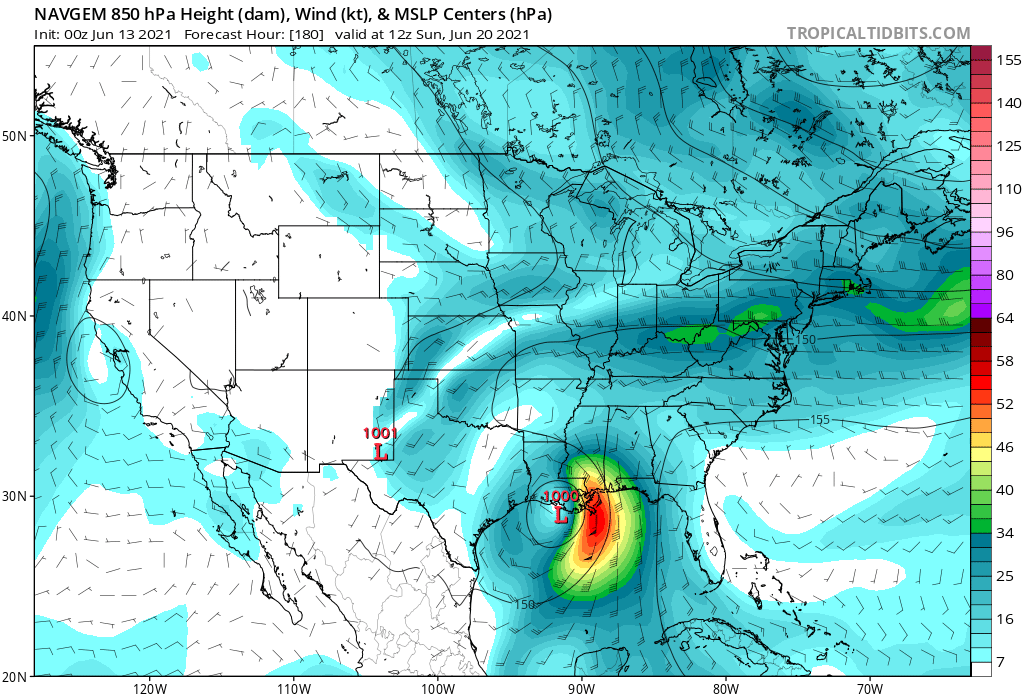
aspen wrote:Kingarabian wrote:aspen wrote:The 18z HWRF has a similar result: mid 990s, winds around 45-50 kt. In this run so far, 92L has not been pushed on shore as of midday Tuesday and remains over water.
18z HWRF:
https://i.imgur.com/oCkro8q.png
For this run, 92L actually remains fairly well stacked with a decent moisture pocket. While there is some offset and dry air trying to get in, it’s far better than 03E and not enough to kill it. The system also remains off the coast at least through mid-week, meaning that if it survives the onslaught of shear from the huge ridge, then it could be in a decent spot to recover once shear drops.
But that’s all assuming it even develops close to the time and position this single HWRF run predicts it’ll be. I won’t be surprised if even the next run shows some heavily tilted slop-storm being pushed into Mexico.
18z HMON makes this a hurricane... but in the EPAC lol. The Mexican terrain makes the models do a bunch of weird stuff.
This setup is going to give the HWRF/HMON a big fit.

HMON crosses over 92L into the EPAC and makes it a hurricane in the exact same spot it makes 93E a hurricane. HWRF crosses over 93E to the BOC and makes it a hurricane in the exact same spot it makes 92L a moderate TS.
1 likes
RIP Kobe Bryant
-
captainbarbossa19
- Professional-Met
- Posts: 1094
- Age: 27
- Joined: Wed Aug 21, 2019 11:09 pm
- Location: Beaumont, TX
Re: ATL: INVEST 92L - Models
BigB0882 wrote:PTrackerLA wrote:captainbarbossa19 wrote:Did anyone see that the Euro is wanting to drop about 40 inches of rain in Central Louisiana from this system? That is really bad.
Yeah 39.8" directly over my house. No thank you.
What is it showing for BTR? I am hoping it is a sharp gradient. That was enough rain to flood us in 2016 and we nearly had water in the house a few weeks ago with the insane downpours that resulted in a foot of rain in a few hours. Too much PTSD.
And for the record, I hope it is just plain wrong for everyone. No one needs or can handle 40 inches of rain.
Euro shows 20+ inches for BTR. GFS has around 1.5 inches. Ummm....that's quite a dispute.
1 likes
-
JW-_-
Re: ATL: INVEST 92L - Models

https://imgur.com/UFekKat
Is looking possibly an entry-level cane on the 18z.

12Z eps was more to the east with moisture flooding potential.
0 likes
-
jaxfladude
- Category 5
- Posts: 1249
- Joined: Wed Aug 24, 2005 9:36 pm
- Location: Jacksonville, Fla
Re: ATL: INVEST 92L - Models
Great 2021 trying go full 2020....prayers if this verifies.....
0 likes
Stay safe y'all
-
JW-_-
Re: ATL: INVEST 92L - Models


GFS 00Z


...............................................................................................................................................................
00Z EC deterministic doesn't do much @ all with this. Its the outliner on the current 00z's global models run.
2 likes
-
JW-_-


-
Hypercane_Kyle

- Category 5
- Posts: 3465
- Joined: Sat Mar 07, 2015 7:58 pm
- Location: Cape Canaveral, FL
Re: ATL: INVEST 92L - Models
Mostly good model consensus for at least a moderate tropical storm this morning. 00z Euro being the usual outlier with no development.
1 likes
My posts are my own personal opinion, defer to the National Hurricane Center (NHC) and other NOAA products for decision making during hurricane season.
Who is online
Users browsing this forum: No registered users and 22 guests