
93L INVEST 210614 0000 32.3N 77.1W ATL 20 1008
ATL: BILL - Post-Tropical - Discussion
Moderator: S2k Moderators
-
Sciencerocks
- Category 5

- Posts: 10186
- Age: 40
- Joined: Thu Jul 06, 2017 1:51 am
Re: ATL: INVEST 93L - Discussion
wow, this isn't kidding. This may get named before 92L based on the circulation and convection blowing up over it!
2 likes
-
NXStumpy_Robothing
- Category 1

- Posts: 335
- Age: 25
- Joined: Fri Jun 05, 2020 11:50 pm
- Location: North Georgia
Re: ATL: INVEST 93L - Discussion
Now 30/30.
2. A well-defined, non-tropical low pressure system is located about
100 miles southeast of Wilmington, North Carolina. Satellite and
radar data indicate that showers and thunderstorms have become a
little more concentrated near the center this morning. Furthermore,
recent satellite-derived wind data and surface observations indicate
that the circulation has become better defined, although the system
is still interacting with a frontal boundary. The low is forecast to
move northeastward for the next few days while passing over or near
the warm Gulf Stream today and Tuesday, which could allow for some
tropical development to occur while the system moves away from the
United States. The low should move over colder waters south of Nova
Scotia by early Wednesday, ending any opportunity for further
development.
* Formation chance through 48 hours...low...30 percent.
* Formation chance through 5 days...low...30 percent.
Forecaster Stewart
0 likes
Undergraduate Meteorology Student, Georgia Institute of Technology
-
Sciencerocks
- Category 5
- Posts: 10186
- Age: 40
- Joined: Thu Jul 06, 2017 1:51 am
-
ElectricStorm

- Category 5
- Posts: 5148
- Age: 25
- Joined: Tue Aug 13, 2019 11:23 pm
- Location: Norman, OK
Re: ATL: INVEST 93L - Discussion
Kinda came out of nowhere. Might steal Bill from 92L even.
0 likes
B.S Meteorology, University of Oklahoma '25
Please refer to the NHC, NWS, or SPC for official information.
Please refer to the NHC, NWS, or SPC for official information.
Re: ATL: INVEST 93L - Discussion
Special tropical weather outlook issued to update the discussion of
the low-pressure system offshore the North Carolina coast.
Updated: A well-defined, non-tropical low pressure system is
located about 120 miles south of Cape Hatteras, North Carolina.
Satellite and radar data indicate that thunderstorm activity has
continued to increase and become more concentrated near the center
of the low early this morning, and environmental conditions are
expected to be at least marginally conducive for tropical cyclone
formation. If this recent development trend continues, then a
short-lived tropical depression or tropical storm could form later
today while the system moves northeastward away from the United
States. The low will move over colder waters south of Nova Scotia
on Wednesday, ending any opportunity for further development.
* Formation chance through 48 hours...medium...50 percent.
* Formation chance through 5 days...medium...50 percent.
1 likes

Re: ATL: INVEST 93L - Discussion
I think it warrants far higher than 50%. Too bad there's no site at Hatteras anymore.

4 likes
The above post is not official and should not be used as such. It is the opinion of the poster and may or may not be backed by sound meteorological data. It is not endorsed by any professional institution or storm2k.org. For official information, please refer to the NHC and NWS products.
-
Shell Mound
- Category 5
- Posts: 2432
- Age: 33
- Joined: Thu Sep 07, 2017 3:39 pm
- Location: St. Petersburg, FL → Scandinavia
Re: ATL: INVEST 93L - Discussion
Hammy wrote:I think it warrants far higher than 50%. Too bad there's no site at Hatteras anymore.
https://i.imgur.com/1rYCTMN.gif
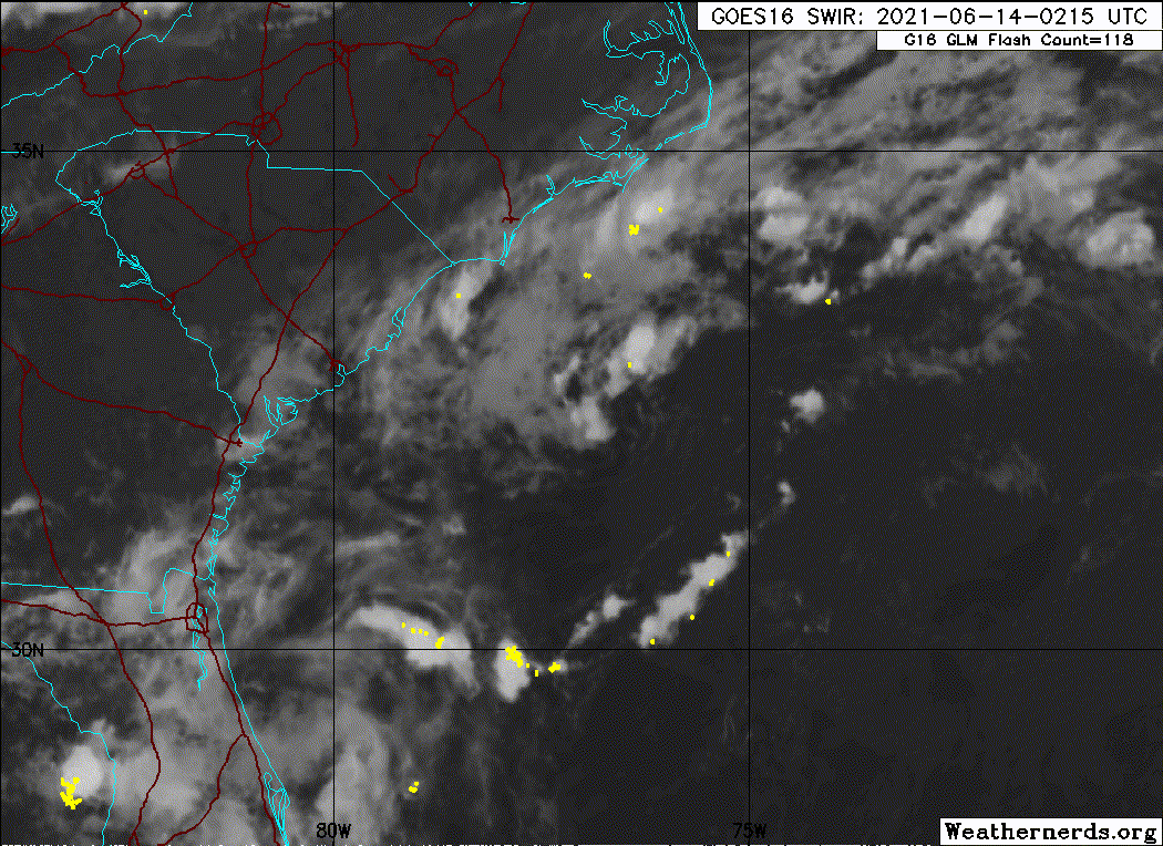
The vigorous MLC is a bit displaced from the LLC to its WSW, but storm-relative VWS is lessening due to favourable interaction with the trough, along with increasing divergence with height. 93L already looks to be very close to TS status, and will almost certainly become TS Bill within the next few hours. The latest shortwave imagery definitely indicates an increasingly organised system that is on the very cusp of TS-level intensity. The velocities on radar definitely support this. On the other hand, there are some potential issues in regard to classification:
https://twitter.com/webberweather/status/1404380846274928644
https://twitter.com/webberweather/status/1404382968995401733
https://twitter.com/webberweather/status/1404384034772246537
https://twitter.com/webberweather/status/1404385562778161154
0 likes
CVW / MiamiensisWx / Shell Mound
The posts in this forum are NOT official forecasts and should not be used as such. They are just the opinion of the poster and may or may not be backed by sound meteorological data. They are NOT endorsed by any professional institution or STORM2K. For official information, please refer to products from the NHC and NWS.
-
Aric Dunn
- Category 5
- Posts: 21238
- Age: 43
- Joined: Sun Sep 19, 2004 9:58 pm
- Location: Ready for the Chase.
- Contact:
Re: ATL: INVEST 93L - Discussion
We shall see.. would not take much more sustained convection to break whats left of that attachment.
The thing about the definition "attached" to a trough is ....that it does not say how far from the center.... essentially within its little "bubble" currently its almost certainly tropical. the attachment to the trough is well away from overall circ. if the outer fringe of the circ interacts with a trough does that magically stop it from being tropical .. no... the physics are still at play..
its only a definition.
2 likes
Note: If I make a post that is brief. Please refer back to previous posts for the analysis or reasoning. I do not re-write/qoute what my initial post said each time.
If there is nothing before... then just ask
Space & Atmospheric Physicist, Embry-Riddle Aeronautical University,
I believe the sky is falling...
If there is nothing before... then just ask
Space & Atmospheric Physicist, Embry-Riddle Aeronautical University,
I believe the sky is falling...
Re: ATL: INVEST 93L - Discussion
The 3km NAM blew that up yesterday on the 06z run, but nothing else backed it up and the 12z did not develop it.
0 likes
-
Aric Dunn
- Category 5
- Posts: 21238
- Age: 43
- Joined: Sun Sep 19, 2004 9:58 pm
- Location: Ready for the Chase.
- Contact:
Re: ATL: INVEST 93L - Discussion
xironman wrote:The 3km NAM blew that up yesterday on the 06z run, but nothing else backed it up and the 12z did not develop it.
Models miss things ALL THE TIME.
1 likes
Note: If I make a post that is brief. Please refer back to previous posts for the analysis or reasoning. I do not re-write/qoute what my initial post said each time.
If there is nothing before... then just ask
Space & Atmospheric Physicist, Embry-Riddle Aeronautical University,
I believe the sky is falling...
If there is nothing before... then just ask
Space & Atmospheric Physicist, Embry-Riddle Aeronautical University,
I believe the sky is falling...
-
Aric Dunn
- Category 5
- Posts: 21238
- Age: 43
- Joined: Sun Sep 19, 2004 9:58 pm
- Location: Ready for the Chase.
- Contact:
Re: ATL: INVEST 93L - Discussion
the last 30 min or so has seen what appears to the start of a proto inner core structure on radar..
they will likely have to pull the trigger on this one here shortly.

they will likely have to pull the trigger on this one here shortly.
4 likes
Note: If I make a post that is brief. Please refer back to previous posts for the analysis or reasoning. I do not re-write/qoute what my initial post said each time.
If there is nothing before... then just ask
Space & Atmospheric Physicist, Embry-Riddle Aeronautical University,
I believe the sky is falling...
If there is nothing before... then just ask
Space & Atmospheric Physicist, Embry-Riddle Aeronautical University,
I believe the sky is falling...

Re: ATL: INVEST 93L - Discussion
Aric Dunn wrote:the last 30 min or so has seen what appears to the start of a proto inner core structure on radar..
they will likely have to pull the trigger on this one here shortly.
https://i.ibb.co/JnKw8q8/Capture.png
I’d say they increase the development odds to 70/70 and wait for 93L to sustain this look before they pull the trigger.
0 likes
Irene '11 Sandy '12 Hermine '16 5/15/2018 Derecho Fay '20 Isaias '20 Elsa '21 Henri '21 Ida '21
I am only a meteorology enthusiast who knows a decent amount about tropical cyclones. Look to the professional mets, the NHC, or your local weather office for the best information.
I am only a meteorology enthusiast who knows a decent amount about tropical cyclones. Look to the professional mets, the NHC, or your local weather office for the best information.
-
Aric Dunn
- Category 5
- Posts: 21238
- Age: 43
- Joined: Sun Sep 19, 2004 9:58 pm
- Location: Ready for the Chase.
- Contact:
Re: ATL: INVEST 93L - Discussion
aspen wrote:Aric Dunn wrote:the last 30 min or so has seen what appears to the start of a proto inner core structure on radar..
they will likely have to pull the trigger on this one here shortly.
https://i.ibb.co/JnKw8q8/Capture.png
I’d say they increase the development odds to 70/70 and wait for 93L to sustain this look before they pull the trigger.
8 am it should go up for sure.
if they don't at 11am and it continues on this trend.. 5pm should be Bill.
0 likes
Note: If I make a post that is brief. Please refer back to previous posts for the analysis or reasoning. I do not re-write/qoute what my initial post said each time.
If there is nothing before... then just ask
Space & Atmospheric Physicist, Embry-Riddle Aeronautical University,
I believe the sky is falling...
If there is nothing before... then just ask
Space & Atmospheric Physicist, Embry-Riddle Aeronautical University,
I believe the sky is falling...
-
Aric Dunn
- Category 5
- Posts: 21238
- Age: 43
- Joined: Sun Sep 19, 2004 9:58 pm
- Location: Ready for the Chase.
- Contact:
Re: ATL: INVEST 93L - Discussion
Partial 'eyewall' structure starting to develop...

5 likes
Note: If I make a post that is brief. Please refer back to previous posts for the analysis or reasoning. I do not re-write/qoute what my initial post said each time.
If there is nothing before... then just ask
Space & Atmospheric Physicist, Embry-Riddle Aeronautical University,
I believe the sky is falling...
If there is nothing before... then just ask
Space & Atmospheric Physicist, Embry-Riddle Aeronautical University,
I believe the sky is falling...
-
Aric Dunn
- Category 5
- Posts: 21238
- Age: 43
- Joined: Sun Sep 19, 2004 9:58 pm
- Location: Ready for the Chase.
- Contact:
Re: ATL: INVEST 93L - Discussion
Tropical Weather Outlook
NWS National Hurricane Center Miami FL
800 AM EDT Mon Jun 14 2021
For the North Atlantic...Caribbean Sea and the Gulf of Mexico:
Satellite, radar and surface observations indicate that a
well-defined low pressure system located about 90 miles southeast of
Cape Hatteras, North Carolina, is acquiring more tropical
characteristics. Environmental conditions appear conducive for
further development, and a tropical depression or tropical storm is
likely to form later today or tonight. This system is expected to
move northeastward away from the United States and move over colder
waters south of Nova Scotia on Wednesday, ending any opportunity for
further development by midweek.
* Formation chance through 48 hours...high...70 percent.
* Formation chance through 5 days...high...70 percent.
0 likes
Note: If I make a post that is brief. Please refer back to previous posts for the analysis or reasoning. I do not re-write/qoute what my initial post said each time.
If there is nothing before... then just ask
Space & Atmospheric Physicist, Embry-Riddle Aeronautical University,
I believe the sky is falling...
If there is nothing before... then just ask
Space & Atmospheric Physicist, Embry-Riddle Aeronautical University,
I believe the sky is falling...
-
MGC

- S2K Supporter

- Posts: 5940
- Joined: Sun Mar 23, 2003 9:05 pm
- Location: Pass Christian MS, or what is left.
Re: ATL: INVEST 93L - Discussion
Gulf Stream working its magic, should be Bill later today.....MGC
0 likes
-
Aric Dunn
- Category 5
- Posts: 21238
- Age: 43
- Joined: Sun Sep 19, 2004 9:58 pm
- Location: Ready for the Chase.
- Contact:
Re: ATL: INVEST 93L - Discussion
The Trends continue pretty quickly right now..
probably will be bill at 11 am.
probably will be bill at 11 am.
1 likes
Note: If I make a post that is brief. Please refer back to previous posts for the analysis or reasoning. I do not re-write/qoute what my initial post said each time.
If there is nothing before... then just ask
Space & Atmospheric Physicist, Embry-Riddle Aeronautical University,
I believe the sky is falling...
If there is nothing before... then just ask
Space & Atmospheric Physicist, Embry-Riddle Aeronautical University,
I believe the sky is falling...
-
Iceresistance

- Category 5
- Posts: 9598
- Age: 22
- Joined: Sat Oct 10, 2020 9:45 am
- Location: Tecumseh, OK/Norman, OK
Re: ATL: INVEST 93L - Discussion
Spotted a impressive rainband, & a lot of Lightning in there as well on Satellite.
On the Mobile version of S2K
On the Mobile version of S2K
0 likes
Bill 2015 & Beta 2020
Winter 2020-2021
All observations are in Tecumseh, OK unless otherwise noted.
Winter posts are focused mainly for Oklahoma & Texas.
Take any of my forecasts with a grain of salt, refer to the NWS, SPC, and NHC for official information
Never say Never with weather! Because ANYTHING is possible!
Winter 2020-2021
All observations are in Tecumseh, OK unless otherwise noted.
Winter posts are focused mainly for Oklahoma & Texas.
Take any of my forecasts with a grain of salt, refer to the NWS, SPC, and NHC for official information
Never say Never with weather! Because ANYTHING is possible!
-
Nancy Smar

- Category 5
- Posts: 1081
- Age: 25
- Joined: Wed Aug 16, 2017 10:03 pm
Re: ATL: INVEST 93L - Discussion
TXNT26 KNES 141146
TCSNTL
A. TROPICAL DISTURBANCE (93L)
B. 14/1131Z
C. 34.5N
D. 74.5W
E. THREE/GOES-E
F. T1.0/1.0
G. IR/EIR/VIS
H. REMARKS...>2/10 BANDING AROUND LLCC YIELDS DT OF 1.0. MET AND PT
AGREE AND FT IS BASED ON DT.
I. ADDL POSITIONS
NIL
...MLEVINE
TCSNTL
A. TROPICAL DISTURBANCE (93L)
B. 14/1131Z
C. 34.5N
D. 74.5W
E. THREE/GOES-E
F. T1.0/1.0
G. IR/EIR/VIS
H. REMARKS...>2/10 BANDING AROUND LLCC YIELDS DT OF 1.0. MET AND PT
AGREE AND FT IS BASED ON DT.
I. ADDL POSITIONS
NIL
...MLEVINE
0 likes
Who is online
Users browsing this forum: No registered users and 18 guests