ATL: INVEST 94L - Discussion
Moderator: S2k Moderators
-
CrazyC83
- Professional-Met

- Posts: 34315
- Joined: Tue Mar 07, 2006 11:57 pm
- Location: Deep South, for the first time!
Re: ATL: INVEST 94L - Discussion
An active wave train early seems to lead to busy seasons in the deep tropics. Thinking 2017, 2010 and 1996 among them.
1 likes
-
ScottNAtlanta

- Category 5

- Posts: 2535
- Joined: Sat May 25, 2013 3:11 pm
- Location: Atlanta, GA
Re: ATL: INVEST 94L - Discussion
While the MDR might not be as warm as previous years...it will be "warm enough". SSTs are just one piece of the thermodynamic puzzle that includes how the temps are in the atmospheric as you go up and the temperatures in the adjacent waters.
6 likes
The posts in this forum are NOT official forecast and should not be used as such. They are just the opinion of the poster and may or may not be backed by sound meteorological data. They are NOT endorsed by any professional institution or storm2k.org. For official information, please refer to the NHC and NWS products.
-
Stormybajan

- Category 1

- Posts: 453
- Joined: Thu May 20, 2021 3:21 pm
- Location: Windward Islands
Re: ATL: INVEST 94L - Discussion
Interestingly, 18z gfs doesnt seem to be as enthusiastic on developing 94L as previous runs did
0 likes
Sad West Indies and Manchester United fan ⚽️
-
cycloneye

- Admin

- Posts: 149550
- Age: 69
- Joined: Thu Oct 10, 2002 10:54 am
- Location: San Juan, Puerto Rico
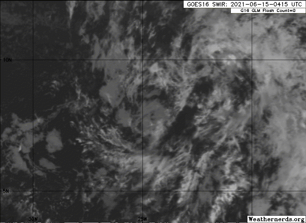
Re: ATL: INVEST 94L - Discussion
A strong tropical wave located several hundred miles south of the
Cabo Verde Islands is producing a large area of cloudiness and a few
showers and thunderstorms. Some development of this system is
possible during the next few days before a combination of dry air
aloft and strong upper-level winds limit any chance of formation
while the wave is over the central tropical Atlantic Ocean late this
week.
* Formation chance through 48 hours...low...10 percent.
* Formation chance through 5 days...low...20 percent.
0 likes
Visit the Caribbean-Central America Weather Thread where you can find at first post web cams,radars
and observations from Caribbean basin members Click Here
and observations from Caribbean basin members Click Here
-
toad strangler

- S2K Supporter

- Posts: 4546
- Joined: Sun Jul 28, 2013 3:09 pm
- Location: Earth
- Contact:
Re: ATL: INVEST 94L - Discussion
94L will struggle and ultimately meet it's demise but at the same time it's at LEAST a full month ahead of it's time.
1 likes
My Weather Station
https://www.wunderground.com/dashboard/pws/KFLPORTS603
https://www.wunderground.com/dashboard/pws/KFLPORTS603
-
cycloneye
- Admin
- Posts: 149550
- Age: 69
- Joined: Thu Oct 10, 2002 10:54 am
- Location: San Juan, Puerto Rico
Re: ATL: INVEST 94L - Discussion
AL, 94, 2021061500, , BEST, 0, 81N, 239W, 25, 1010, DB
0 likes
Visit the Caribbean-Central America Weather Thread where you can find at first post web cams,radars
and observations from Caribbean basin members Click Here
and observations from Caribbean basin members Click Here
-
cycloneye
- Admin
- Posts: 149550
- Age: 69
- Joined: Thu Oct 10, 2002 10:54 am
- Location: San Juan, Puerto Rico
Re: ATL: INVEST 94L - Discussion
5 likes
Visit the Caribbean-Central America Weather Thread where you can find at first post web cams,radars
and observations from Caribbean basin members Click Here
and observations from Caribbean basin members Click Here
-
MarioProtVI
- Category 5
- Posts: 1034
- Age: 24
- Joined: Sun Sep 29, 2019 7:33 pm
- Location: New Jersey
Re: ATL: INVEST 94L - Discussion
94L will probably serve more as a warning sign for the MDR this year, kind of like 2017 with Bret (which came from a similar wave at a similar latitude). Don’t expect Claudette/Danny from this though.
2 likes

Re: ATL: INVEST 94L - Discussion
toad strangler wrote:94L will struggle and ultimately meet it's demise but at the same time it's at LEAST a full month ahead of it's time.
I do recall 1996 having a few fairly strong waves like this in 1996 (and similarly a system form off the Carolinas around this time)--a year that was quite active in the MDR despite none forming quite yet.
0 likes
The above post is not official and should not be used as such. It is the opinion of the poster and may or may not be backed by sound meteorological data. It is not endorsed by any professional institution or storm2k.org. For official information, please refer to the NHC and NWS products.
-
Shell Mound
- Category 5
- Posts: 2432
- Age: 33
- Joined: Thu Sep 07, 2017 3:39 pm
- Location: St. Petersburg, FL → Scandinavia
Re: ATL: INVEST 94L - Discussion
MarioProtVI wrote:94L will probably serve more as a warning sign for the MDR this year, kind of like 2017 with Bret (which came from a similar wave at a similar latitude). Don’t expect Claudette/Danny from this though.
I respectfully disagree. We’ve seen Ana, Bill, and future Claudette (92L) all form in the subtropics vs. the MDR/Caribbean thus far. If anything, this suggests a less active season. Many inactive seasons feature lots of early- and/or preseason storms in the subtropics. If we were seeing tropical storms in the MDR by now, I would be more concerned. But an INVEST designation so far east, at this time of the year, is insufficient cause for alarm, in my view. I can also recall plenty of inactive years that featured at least a few abnormally vigorous, well-organised African easterly waves in June.
1 likes
CVW / MiamiensisWx / Shell Mound
The posts in this forum are NOT official forecasts and should not be used as such. They are just the opinion of the poster and may or may not be backed by sound meteorological data. They are NOT endorsed by any professional institution or STORM2K. For official information, please refer to products from the NHC and NWS.
-
Stormybajan
- Category 1
- Posts: 453
- Joined: Thu May 20, 2021 3:21 pm
- Location: Windward Islands
Re: ATL: INVEST 94L - Discussion
Shell Mound wrote:MarioProtVI wrote:94L will probably serve more as a warning sign for the MDR this year, kind of like 2017 with Bret (which came from a similar wave at a similar latitude). Don’t expect Claudette/Danny from this though.
I respectfully disagree. We’ve seen Ana, Bill, and future Claudette (92L) all form in the subtropics vs. the MDR/Caribbean thus far. If anything, this suggests a less active season. Many inactive seasons feature lots of early- and/or preseason storms in the subtropics. If we were seeing tropical storms in the MDR by now, I would be more concerned. But an INVEST designation so far east, at this time of the year, is insufficient cause for alarm, in my view. I can also recall plenty of inactive years that featured at least a few abnormally vigorous, well-organised African easterly waves in June.
I have two arguments against that:
1. AEW based invests in the MDR are rare in June, this tells me the WAM and the strength of the tropical waves are above average and are usually a precursor for an active season (2010,2017)
2. I dont believe having early development in the subtropics hints at a below average season, plenty of our recent seasons in this 5 years active streak (2016-2020) have had develop in the subtropics, it shouldnt be a cause for alarm nor be seen as a sign of a slow season
8 likes
Sad West Indies and Manchester United fan ⚽️
-
Sciencerocks
- Category 5
- Posts: 10186
- Age: 40
- Joined: Thu Jul 06, 2017 1:51 am
-
ElectricStorm

- Category 5
- Posts: 5148
- Age: 25
- Joined: Tue Aug 13, 2019 11:23 pm
- Location: Norman, OK
Re: ATL: INVEST 94L - Discussion
Shell Mound wrote:MarioProtVI wrote:94L will probably serve more as a warning sign for the MDR this year, kind of like 2017 with Bret (which came from a similar wave at a similar latitude). Don’t expect Claudette/Danny from this though.
I respectfully disagree. We’ve seen Ana, Bill, and future Claudette (92L) all form in the subtropics vs. the MDR/Caribbean thus far. If anything, this suggests a less active season. Many inactive seasons feature lots of early- and/or preseason storms in the subtropics. If we were seeing tropical storms in the MDR by now, I would be more concerned. But an INVEST designation so far east, at this time of the year, is insufficient cause for alarm, in my view. I can also recall plenty of inactive years that featured at least a few abnormally vigorous, well-organised African easterly waves in June.
Last year had quite a bit of early activity in the subtropics and look what happened... I don't think early activity in the subtropics leads to an inactive season. But I do get what you're saying though as yes, there have been inactive seasons with early activity. But to me, I think this is more of a signal of an above average season to come, not below average.
3 likes
B.S Meteorology, University of Oklahoma '25
Please refer to the NHC, NWS, or SPC for official information.
Please refer to the NHC, NWS, or SPC for official information.

Re: ATL: INVEST 94L - Discussion
Shell Mound wrote:MarioProtVI wrote:94L will probably serve more as a warning sign for the MDR this year, kind of like 2017 with Bret (which came from a similar wave at a similar latitude). Don’t expect Claudette/Danny from this though.
I respectfully disagree. We’ve seen Ana, Bill, and future Claudette (92L) all form in the subtropics vs. the MDR/Caribbean thus far. If anything, this suggests a less active season. Many inactive seasons feature lots of early- and/or preseason storms in the subtropics. If we were seeing tropical storms in the MDR by now, I would be more concerned. But an INVEST designation so far east, at this time of the year, is insufficient cause for alarm, in my view. I can also recall plenty of inactive years that featured at least a few abnormally vigorous, well-organised African easterly waves in June.
All of the last several active seasons had June or July storms in the subtropics. However, if 2021 only has subtropic systems in July, then it’ll be a potential signal of an inactive year (see the seasonal indicators thread).
With a wave like this in mid June during a SAL outbreak, it seems probable that a MDR TC could form in July when conditions have improved.
0 likes
Irene '11 Sandy '12 Hermine '16 5/15/2018 Derecho Fay '20 Isaias '20 Elsa '21 Henri '21 Ida '21
I am only a meteorology enthusiast who knows a decent amount about tropical cyclones. Look to the professional mets, the NHC, or your local weather office for the best information.
I am only a meteorology enthusiast who knows a decent amount about tropical cyclones. Look to the professional mets, the NHC, or your local weather office for the best information.
-
cycloneye
- Admin
- Posts: 149550
- Age: 69
- Joined: Thu Oct 10, 2002 10:54 am
- Location: San Juan, Puerto Rico
Re: ATL: INVEST 94L - Discussion
Showers and thunderstorms have decreased and become less organized
during the past several hours in association with a tropical wave
located a few hundred miles south of the Cabo Verde Islands.
Development, if any, should be slow to occur during the next couple
of days while the wave moves westward. Thereafter, a combination of
dry air aloft and strong upper-level winds should limit the chances
of formation when the wave reaches the central tropical Atlantic.
* Formation chance through 48 hours...low...10 percent.
* Formation chance through 5 days...low...10 percent.
2 likes
Visit the Caribbean-Central America Weather Thread where you can find at first post web cams,radars
and observations from Caribbean basin members Click Here
and observations from Caribbean basin members Click Here
-
Hypercane_Kyle

- Category 5
- Posts: 3465
- Joined: Sat Mar 07, 2015 7:58 pm
- Location: Cape Canaveral, FL
Re: ATL: INVEST 94L - Discussion
Shell Mound wrote:MarioProtVI wrote:94L will probably serve more as a warning sign for the MDR this year, kind of like 2017 with Bret (which came from a similar wave at a similar latitude). Don’t expect Claudette/Danny from this though.
I respectfully disagree. We’ve seen Ana, Bill, and future Claudette (92L) all form in the subtropics vs. the MDR/Caribbean thus far. If anything, this suggests a less active season. Many inactive seasons feature lots of early- and/or preseason storms in the subtropics. If we were seeing tropical storms in the MDR by now, I would be more concerned. But an INVEST designation so far east, at this time of the year, is insufficient cause for alarm, in my view. I can also recall plenty of inactive years that featured at least a few abnormally vigorous, well-organised African easterly waves in June.
Not really? Most of 2020's early season storms formed in the subtropics and look how that turned out for the Caribbean. And 92L is in the Gulf of Mexico, not the subtropics.
0 likes
My posts are my own personal opinion, defer to the National Hurricane Center (NHC) and other NOAA products for decision making during hurricane season.
-
Shell Mound
- Category 5
- Posts: 2432
- Age: 33
- Joined: Thu Sep 07, 2017 3:39 pm
- Location: St. Petersburg, FL → Scandinavia
Re: ATL: INVEST 94L - Discussion
Weather Dude wrote:Shell Mound wrote:MarioProtVI wrote:94L will probably serve more as a warning sign for the MDR this year, kind of like 2017 with Bret (which came from a similar wave at a similar latitude). Don’t expect Claudette/Danny from this though.
I respectfully disagree. We’ve seen Ana, Bill, and future Claudette (92L) all form in the subtropics vs. the MDR/Caribbean thus far. If anything, this suggests a less active season. Many inactive seasons feature lots of early- and/or preseason storms in the subtropics. If we were seeing tropical storms in the MDR by now, I would be more concerned. But an INVEST designation so far east, at this time of the year, is insufficient cause for alarm, in my view. I can also recall plenty of inactive years that featured at least a few abnormally vigorous, well-organised African easterly waves in June.
Last year had quite a bit of early activity in the subtropics and look what happened... I don't think early activity in the subtropics leads to an inactive season. But I do get what you're saying though as yes, there have been inactive seasons with early activity. But to me, I think this is more of a signal of an above average season to come, not below average.
Another point of mine is that it is difficult to gauge how “impressive” 94L is without a thorough database of tropical waves going back several decades.
1 likes
CVW / MiamiensisWx / Shell Mound
The posts in this forum are NOT official forecasts and should not be used as such. They are just the opinion of the poster and may or may not be backed by sound meteorological data. They are NOT endorsed by any professional institution or STORM2K. For official information, please refer to products from the NHC and NWS.
-
hurricanehunter69
- Category 1
- Posts: 344
- Joined: Sun May 16, 2010 5:21 pm
- Location: New Orleans
Re: ATL: INVEST 94L - Discussion
Should we be concerned about the relative lack of SAL so far?
0 likes
-
Stormybajan
- Category 1
- Posts: 453
- Joined: Thu May 20, 2021 3:21 pm
- Location: Windward Islands
Re: ATL: INVEST 94L - Discussion
hurricanehunter69 wrote:Should we be concerned about the relative lack of SAL so far?
Atleast im not the only one who has noticed the SAL plumes so far in June havent been as prevalent as im used to, but im sure in ate June-July they will be right on track im sure
1 likes
Sad West Indies and Manchester United fan ⚽️
-
StPeteMike

- Category 2

- Posts: 656
- Joined: Thu Jun 07, 2018 11:26 pm
Re: ATL: INVEST 94L - Discussion
The past week has seen beneficial rain to west Africa. If the weather pattern stays the same into July and August, we will have more to worry about.
0 likes
The above post is not official and should not be used as such. It is the opinion of the poster and may or may not be backed by sound meteorological data. It is not endorsed by any professional institution or storm2k.org. For official information, please refer to the NHC and NWS products.
Who is online
Users browsing this forum: No registered users and 16 guests