
EPAC: ENRIQUE - Remnants
Moderator: S2k Moderators
-
Sciencerocks
- Category 5

- Posts: 10186
- Age: 40
- Joined: Thu Jul 06, 2017 1:51 am
-
Yellow Evan

- Professional-Met

- Posts: 16240
- Age: 27
- Joined: Fri Jul 15, 2011 12:48 pm
- Location: Henderson, Nevada/Honolulu, HI
- Contact:

-
cycloneye

- Admin

- Posts: 149508
- Age: 69
- Joined: Thu Oct 10, 2002 10:54 am
- Location: San Juan, Puerto Rico
Re: EPAC: INVEST 95E
Tropical Weather Outlook
NWS National Hurricane Center Miami FL
1100 AM PDT Thu Jun 24 2021
For the eastern North Pacific...east of 140 degrees west longitude:
1. Showers and thunderstorms continue to show some signs of
organization in association with a low pressure system located a
couple of hundred miles south of southern Mexico. However, recent
satellite wind data indicates that the circulation is still broad
and elongated. Environmental conditions are conducive for gradual
development, and a tropical depression is expected to form in a day
or two while the disturbance moves west-northwestward at about 10
mph. This system is expected to be near the coast of southern or
southwestern Mexico through the weekend, and interests in those
areas should monitor its potential for development, as well as the
threat of heavy rainfall and flooding.
* Formation chance through 48 hours...high...80 percent.
* Formation chance through 5 days...high...90 percent.
Forecaster Cangialosi
0 likes
Visit the Caribbean-Central America Weather Thread where you can find at first post web cams,radars
and observations from Caribbean basin members Click Here
and observations from Caribbean basin members Click Here
-
Yellow Evan
- Professional-Met
- Posts: 16240
- Age: 27
- Joined: Fri Jul 15, 2011 12:48 pm
- Location: Henderson, Nevada/Honolulu, HI
- Contact:

-
Yellow Evan
- Professional-Met
- Posts: 16240
- Age: 27
- Joined: Fri Jul 15, 2011 12:48 pm
- Location: Henderson, Nevada/Honolulu, HI
- Contact:

-
Kingarabian

- S2K Supporter

- Posts: 16366
- Joined: Sat Aug 08, 2009 3:06 am
- Location: Honolulu, Hawaii

-
Yellow Evan
- Professional-Met
- Posts: 16240
- Age: 27
- Joined: Fri Jul 15, 2011 12:48 pm
- Location: Henderson, Nevada/Honolulu, HI
- Contact:
Re: EPAC: INVEST 95E

18z GFS calls for a 977 mbar in 84 hours before this stalls near Socorro Island and eventually weakens as it turns a little towards the east.
0 likes
-
Kingarabian
- S2K Supporter
- Posts: 16366
- Joined: Sat Aug 08, 2009 3:06 am
- Location: Honolulu, Hawaii
Re: EPAC: INVEST 95E
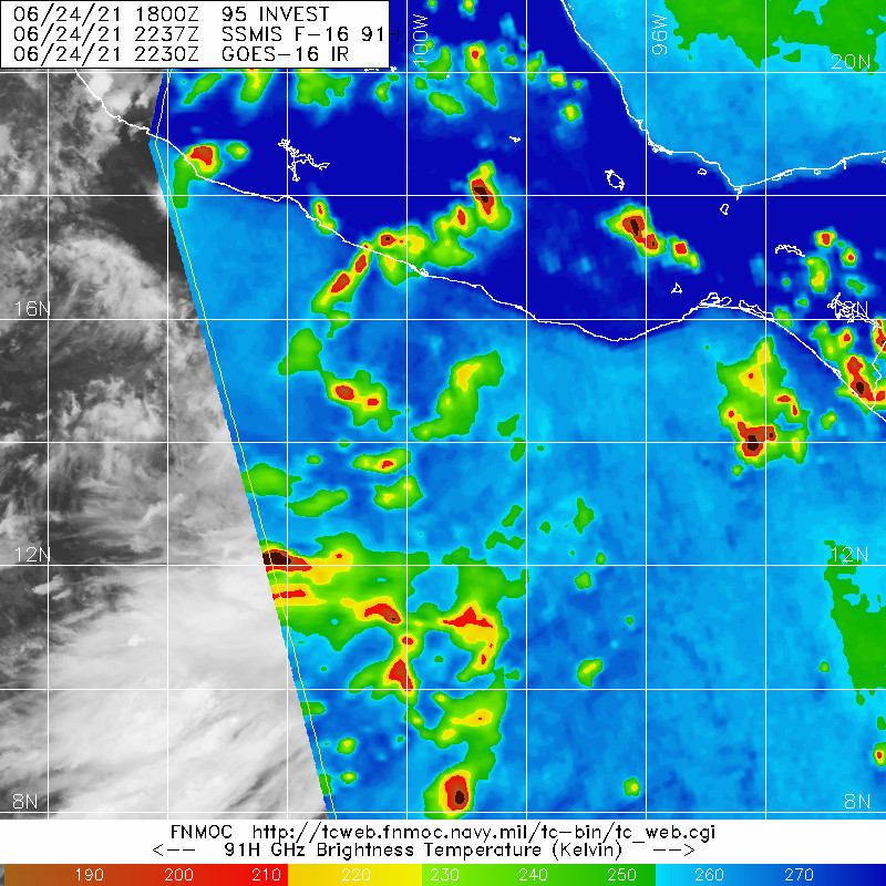
95E is certainly competing with the system to its west:


0 likes
RIP Kobe Bryant
-
Kingarabian
- S2K Supporter
- Posts: 16366
- Joined: Sat Aug 08, 2009 3:06 am
- Location: Honolulu, Hawaii
Re: EPAC: INVEST 95E
For the eastern North Pacific...east of 140 degrees west longitude:
1. Showers and thunderstorms continue to show signs of organization in
association with a low pressure system located about 150 miles
south-southwest of Acapulco, Mexico. However, the low's surface
circulation still appears broad without a well-defined center.
Environmental conditions are conducive for additional development,
and a tropical depression or tropical storm is expected to form in a
day or so while moving slowly west-northwestward at 5 to 10 mph.
This system is expected to be near the coast of southwestern Mexico
through early next week, and interests there should monitor its
potential for development, as well as the threat of heavy rainfall
and flooding. For additional information on this system, please
refer to High Seas Forecasts issued by the National Weather Service.
* Formation chance through 48 hours...high...90 percent.
* Formation chance through 5 days...high...90 percent.
0 likes
RIP Kobe Bryant
-
Sciencerocks
- Category 5
- Posts: 10186
- Age: 40
- Joined: Thu Jul 06, 2017 1:51 am

-
Yellow Evan
- Professional-Met
- Posts: 16240
- Age: 27
- Joined: Fri Jul 15, 2011 12:48 pm
- Location: Henderson, Nevada/Honolulu, HI
- Contact:
Re: EPAC: INVEST 95E
Is slowly but steadily organizing. Probably classifiable at this point.
5 likes
-
Kingarabian
- S2K Supporter
- Posts: 16366
- Joined: Sat Aug 08, 2009 3:06 am
- Location: Honolulu, Hawaii
Re: EPAC: INVEST 95E
Very close now, deep circular blue around the NHC center fix on this SSMIS MW pass:
0 likes
RIP Kobe Bryant
-
ElectricStorm

- Category 5
- Posts: 5147
- Age: 25
- Joined: Tue Aug 13, 2019 11:23 pm
- Location: Norman, OK
Re: EPAC: INVEST 95E
95E INVEST 210625 0000 14.8N 100.4W EPAC 30 1007
0 likes
B.S Meteorology, University of Oklahoma '25
Please refer to the NHC, NWS, or SPC for official information.
Please refer to the NHC, NWS, or SPC for official information.
-
Kingarabian
- S2K Supporter
- Posts: 16366
- Joined: Sat Aug 08, 2009 3:06 am
- Location: Honolulu, Hawaii

-
Yellow Evan
- Professional-Met
- Posts: 16240
- Age: 27
- Joined: Fri Jul 15, 2011 12:48 pm
- Location: Henderson, Nevada/Honolulu, HI
- Contact:

-
Sciencerocks
- Category 5
- Posts: 10186
- Age: 40
- Joined: Thu Jul 06, 2017 1:51 am
Re: EPAC: INVEST 95E
Tropical Weather Outlook
NWS National Hurricane Center Miami FL
1100 PM PDT Thu Jun 24 2021
For the eastern North Pacific...east of 140 degrees west longitude:
Recent satellite wind data indicates that the circulation
associated with the area of low pressure located about 170 miles
south-southwest of Acapulco, Mexico, has become better defined and
that winds near tropical-storm force are occurring southeast of the
center. In addition, the associated shower activity is becoming
better organized. If current trends continue, advisories will be
initiated on a tropical depression or tropical storm sometime on
Friday as the system moves west-northwestward at 5 to 10 mph.
This system is expected to be near the coast of southwestern Mexico
through early next week, and interests there should monitor its
potential for development, as well as the threat of heavy rainfall
and flooding. For additional information on this system, please
refer to High Seas Forecasts issued by the National Weather Service.
* Formation chance through 48 hours...high...near 100 percent.
* Formation chance through 5 days...high...near 100 percent.
&&
High Seas Forecasts issued by the National Weather Service can be
found under AWIPS header NFDHSFEPI, WMO header FZPN02 KWBC, and on
the web at ocean.weather.gov/shtml/NFDHSFEPI.php
$$
Forecaster Beven
0 likes
-
Sciencerocks
- Category 5
- Posts: 10186
- Age: 40
- Joined: Thu Jul 06, 2017 1:51 am

-
Kingarabian
- S2K Supporter
- Posts: 16366
- Joined: Sat Aug 08, 2009 3:06 am
- Location: Honolulu, Hawaii
Re: EPAC: INVEST 95E
TXPZ24 KNES 250617
TCSENP
A. TROPICAL DISTURBANCE (95E)
B. 24/2330Z
C. 14.7N
D. 100.0W
E. FIVE/GOES-E
F. T1.5/1.5
G. IR/EIR/VIS
H. REMARKS...SYSTEM HAS 3/10 BANDING RESULTING IN A DT OF 1.5. MET IS
1.0 AND PT IS 1.5. FT IS BASED ON DT.
I. ADDL POSITIONS
NIL
...PATEL
TCSENP
A. TROPICAL DISTURBANCE (95E)
B. 24/2330Z
C. 14.7N
D. 100.0W
E. FIVE/GOES-E
F. T1.5/1.5
G. IR/EIR/VIS
H. REMARKS...SYSTEM HAS 3/10 BANDING RESULTING IN A DT OF 1.5. MET IS
1.0 AND PT IS 1.5. FT IS BASED ON DT.
I. ADDL POSITIONS
NIL
...PATEL
0 likes
RIP Kobe Bryant
-
Nancy Smar

- Category 5
- Posts: 1081
- Age: 25
- Joined: Wed Aug 16, 2017 10:03 pm
Re: EPAC: INVEST 95E
EP052021 - Tropical Storm INVEST
TXPZ24 KNES 250624
TCSENP
A. TROPICAL DISTURBANCE (95E)
B. 25/0530Z
C. 15.1N
D. 100.9W
E. THREE/GOES-E
F. T2.0/2.0
G. IR/EIR/SWIR
H. REMARKS...SYSTEM HAS A CIRCULAR DEFINED LLCC AS INDICATED BY RECENT
0310Z ASCAT PASS NEAR THE LARGE COLD OVERCAST RESULTING IN A SHEAR
PATTERN DT OF 2.0. MET IS 1.5 AND PT IS 2.0. FT IS BASED ON DT.
I. ADDL POSITIONS
NIL
...PATEL
Last edited by Nancy Smar on Fri Jun 25, 2021 3:17 am, edited 1 time in total.
0 likes
-
Nancy Smar
- Category 5
- Posts: 1081
- Age: 25
- Joined: Wed Aug 16, 2017 10:03 pm
Re: EPAC: INVEST 95E
EP, 05, 2021062506, , BEST, 0, 149N, 1012W, 35, 1006, TS, 34, NEQ, 0, 60, 0, 0, 1010, 160, 60, 45, 0, E, 0, , 0, 0, INVEST, M, 0, , 0, 0, 0, 0, genesis-num, 008, TRANSITIONED, epA52021 to ep052021,
1 likes
Who is online
Users browsing this forum: No registered users and 52 guests