ATL: DANNY - Post-Tropical - Discussion
Moderator: S2k Moderators
-
ScottNAtlanta

- Category 5

- Posts: 2535
- Joined: Sat May 25, 2013 3:11 pm
- Location: Atlanta, GA
Re: ATL: INVEST 96L - Discussion
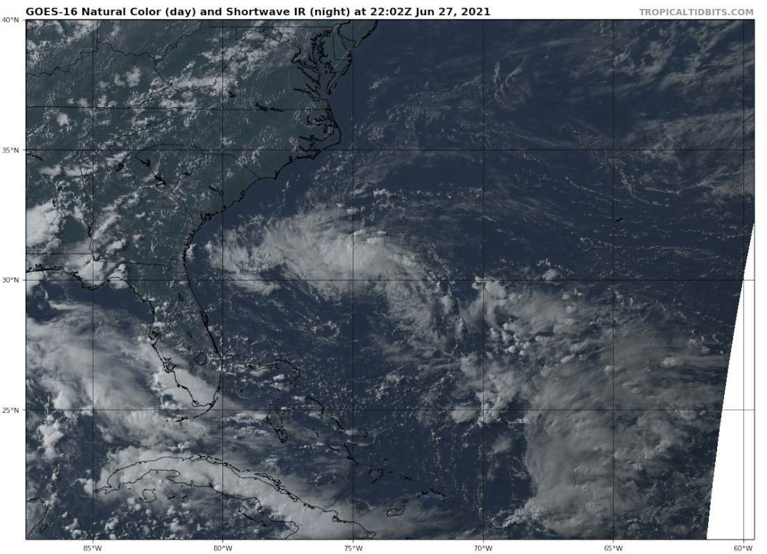
The LLC has pretty much decoupled from the MLC...I dont see an upgrade unless it starts firing over the center again or the center reforms.
0 likes
The posts in this forum are NOT official forecast and should not be used as such. They are just the opinion of the poster and may or may not be backed by sound meteorological data. They are NOT endorsed by any professional institution or storm2k.org. For official information, please refer to the NHC and NWS products.


Re: ATL: INVEST 96L - Discussion
With the LLC moving slower and becoming exposed, it will likely prevent further development tonight. However it will allow the ULL to the west to move further away and possibly making a less hostile environment, it will also give it more time over the gulfstream.
I would bet on this becoming a depression tomorrow. As I posted earlier, the water west of the gulfstream along the Georgia and SC coast is significantly cooler so once this system moves west of the gulfstream it will lose a lot of potential ocean energy....even if this strengthens significantly over the gulfstream tomorrow it will most likely weaken before landfall.
I would bet on this becoming a depression tomorrow. As I posted earlier, the water west of the gulfstream along the Georgia and SC coast is significantly cooler so once this system moves west of the gulfstream it will lose a lot of potential ocean energy....even if this strengthens significantly over the gulfstream tomorrow it will most likely weaken before landfall.
0 likes
-
AlphaToOmega
- Category 5
- Posts: 1448
- Joined: Sat Jun 26, 2021 10:51 am
- Location: Somewhere in Massachusetts
Re: ATL: INVEST 96L - Discussion
Based on what has happened before, I would give this a high chance of development. Tropical Storms Bertha (2020) and Bill (2021) developed out of the blue, and it is possible Invest 96L is added to that list.
1 likes
-
Aric Dunn
- Category 5
- Posts: 21238
- Age: 43
- Joined: Sun Sep 19, 2004 9:58 pm
- Location: Ready for the Chase.
- Contact:
Re: ATL: INVEST 96L - Discussion
Jr0d wrote:With the LLC moving slower and becoming exposed, it will likely prevent further development tonight. However it will allow the ULL to the west to move further away and possibly making a less hostile environment, it will also give it more time over the gulfstream.
I would bet on this becoming a depression tomorrow. As I posted earlier, the water west of the gulfstream along the Georgia and SC coast is significantly cooler so once this system moves west of the gulfstream it will lose a lot of potential ocean energy....even if this strengthens significantly over the gulfstream tomorrow it will most likely weaken before landfall.
water temps all the way up to the coast are in the low 80s.
and yeah as the ULL moves farther away it should alow for this too deepen ovenight.
0 likes
Note: If I make a post that is brief. Please refer back to previous posts for the analysis or reasoning. I do not re-write/qoute what my initial post said each time.
If there is nothing before... then just ask
Space & Atmospheric Physicist, Embry-Riddle Aeronautical University,
I believe the sky is falling...
If there is nothing before... then just ask
Space & Atmospheric Physicist, Embry-Riddle Aeronautical University,
I believe the sky is falling...
-
wxman57

- Moderator-Pro Met

- Posts: 23175
- Age: 68
- Joined: Sat Jun 21, 2003 8:06 pm
- Location: Houston, TX (southwest)
Re: ATL: INVEST 96L - Discussion
Scatterometer data from 1120Z indicate a sharp trof axis at the surface. Any circulation may be aloft. It may have peaked earlier today. Will be inland in about 24 hours.
2 likes
Re: ATL: INVEST 96L - Discussion
Aric Dunn wrote:water temps all the way up to the coast are in the low 80s.
and yeah as the ULL moves farther away it should alow for this too deepen ovenight.
2 to 3°++ cooler near the coast...Tybee Island is at 80.6°, Myrtle Beach is at 78.8°.
There is a lot of water below 80° along the coast of Georgia and South Carolina....this should inhibit significant development after this moves west of the Gulfstream.
0 likes

Re: ATL: INVEST 96L - Discussion
i don’t think this will do too much.
Last edited by robbielyn on Sun Jun 27, 2021 5:22 pm, edited 1 time in total.
0 likes
Robbielyn McCrary
I know just about enough to sound like I know what I'm talking about sometimes. But for your safety please follow the nhc for truly professional forecasting.
I know just about enough to sound like I know what I'm talking about sometimes. But for your safety please follow the nhc for truly professional forecasting.
-
Aric Dunn
- Category 5
- Posts: 21238
- Age: 43
- Joined: Sun Sep 19, 2004 9:58 pm
- Location: Ready for the Chase.
- Contact:
Re: ATL: INVEST 96L - Discussion
Jr0d wrote:Aric Dunn wrote:water temps all the way up to the coast are in the low 80s.
and yeah as the ULL moves farther away it should alow for this too deepen ovenight.
2 to 3°++ cooler near the coast...Tybee Island is at 80.6°, Myrtle Beach is at 78.8°.
There is a lot of water below 80° along the coast of Georgia and South Carolina....this should inhibit significant development after this moves west of the Gulfstream.
check the nearby bouys currently where its at.. they are 79F it has actually been traversing a cool spot left over from the week long stalled front in this area.
bouys less then 20 miles off shore are in the low 80s.. temps go up not down..
anything right along the coast wont effect the system that close to shore.
SO yeah SSTs wont be a problem starting overnight tonight.

2 likes
Note: If I make a post that is brief. Please refer back to previous posts for the analysis or reasoning. I do not re-write/qoute what my initial post said each time.
If there is nothing before... then just ask
Space & Atmospheric Physicist, Embry-Riddle Aeronautical University,
I believe the sky is falling...
If there is nothing before... then just ask
Space & Atmospheric Physicist, Embry-Riddle Aeronautical University,
I believe the sky is falling...
Re: ATL: INVEST 96L - Discussion
AlphaToOmega wrote:Based on what has happened before, I would give this a high chance of development. Tropical Storms Bertha (2020) and Bill (2021) developed out of the blue, and it is possible Invest 96L is added to that list.
yeah but you know how pesky those upper level lows can be.
0 likes
Robbielyn McCrary
I know just about enough to sound like I know what I'm talking about sometimes. But for your safety please follow the nhc for truly professional forecasting.
I know just about enough to sound like I know what I'm talking about sometimes. But for your safety please follow the nhc for truly professional forecasting.

Re: ATL: INVEST 96L - Discussion
What happened to the recon mission? It hasn't updated since 18z.
0 likes
The above post is not official and should not be used as such. It is the opinion of the poster and may or may not be backed by sound meteorological data. It is not endorsed by any professional institution or storm2k.org. For official information, please refer to the NHC and NWS products.
Re: ATL: INVEST 96L - Discussion
Aric Dunn wrote:Jr0d wrote:Aric Dunn wrote:water temps all the way up to the coast are in the low 80s.
and yeah as the ULL moves farther away it should alow for this too deepen ovenight.
2 to 3°++ cooler near the coast...Tybee Island is at 80.6°, Myrtle Beach is at 78.8°.
There is a lot of water below 80° along the coast of Georgia and South Carolina....this should inhibit significant development after this moves west of the Gulfstream.
check the nearby bouys currently where its at.. they are 79F it has actually been traversing a cool spot left over from the week long stalled front in this area.
bouys less then 20 miles off shore are in the low 80s.. temps go up not down..
anything right along the coast wont effect the system that close to shore.
SO yeah SSTs wont be a problem starting overnight tonight.
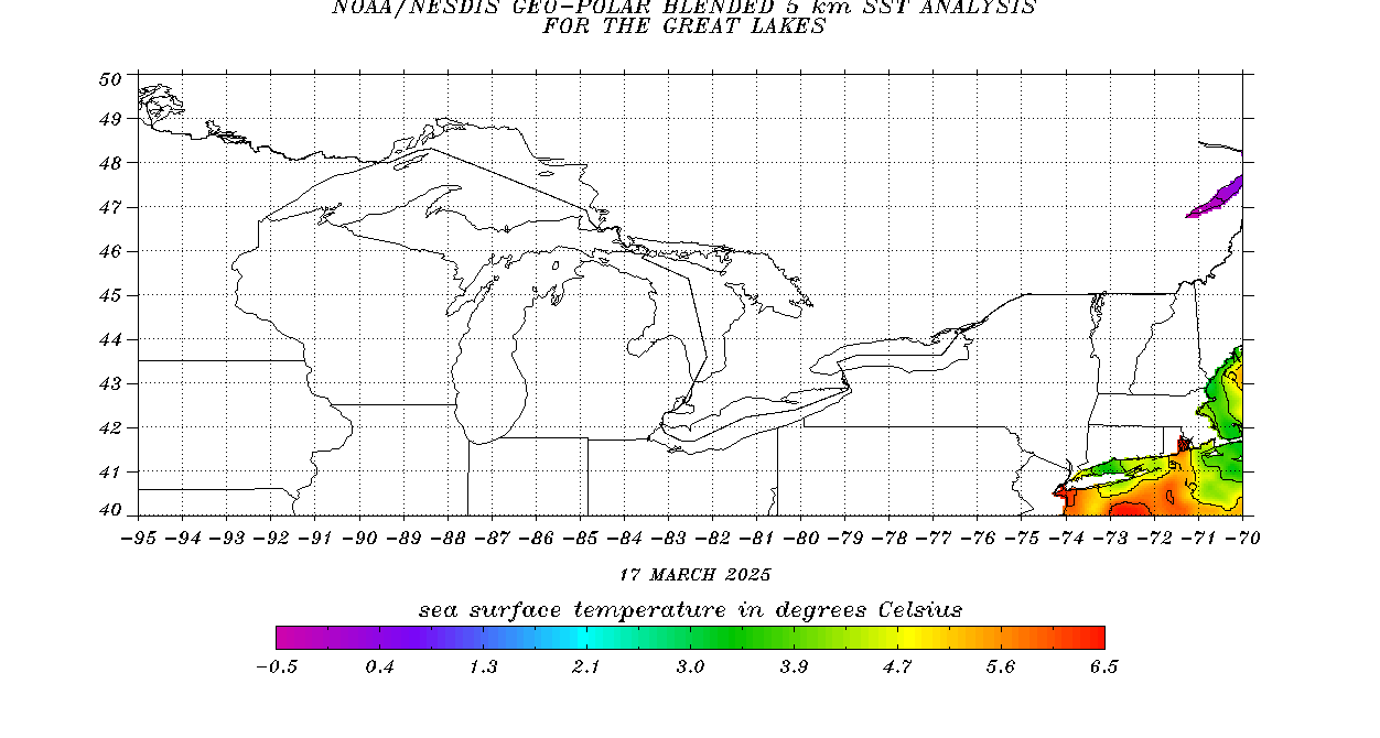
https://i.ibb.co/b1ZjVbR/1.png
Check the temps along the shore....mostly right at 80 or below along the coast of SC and GA....once this moves west of the Gulfstream it will lose a lot of latent heat from the ocean.
Also look at the SSTs on the satellite....a lot of sub 80 water west of the Gulfstream...that buoy maybe in a pool of relatively warmer water compared to the general area.
Last edited by Jr0d on Sun Jun 27, 2021 6:17 pm, edited 1 time in total.
0 likes
-
Aric Dunn
- Category 5
- Posts: 21238
- Age: 43
- Joined: Sun Sep 19, 2004 9:58 pm
- Location: Ready for the Chase.
- Contact:
Re: ATL: INVEST 96L - Discussion
Jr0d wrote:Aric Dunn wrote:Jr0d wrote:
2 to 3°++ cooler near the coast...Tybee Island is at 80.6°, Myrtle Beach is at 78.8°.
There is a lot of water below 80° along the coast of Georgia and South Carolina....this should inhibit significant development after this moves west of the Gulfstream.
check the nearby bouys currently where its at.. they are 79F it has actually been traversing a cool spot left over from the week long stalled front in this area.
bouys less then 20 miles off shore are in the low 80s.. temps go up not down..
anything right along the coast wont effect the system that close to shore.
SO yeah SSTs wont be a problem starting overnight tonight.
https://i.ibb.co/b1ZjVbR/1.png
Check the temps along the shore....mostly right at 80 or below along the coast of SC and GA....once this moves west of the Gulfstream it will lose a lot of latent heat from the ocean.
as mentioned ... the immediate coastal temps will have almost no effect on it. especially moving at 10 to 15 mph.
0 likes
Note: If I make a post that is brief. Please refer back to previous posts for the analysis or reasoning. I do not re-write/qoute what my initial post said each time.
If there is nothing before... then just ask
Space & Atmospheric Physicist, Embry-Riddle Aeronautical University,
I believe the sky is falling...
If there is nothing before... then just ask
Space & Atmospheric Physicist, Embry-Riddle Aeronautical University,
I believe the sky is falling...

Re: ATL: INVEST 96L - Discussion
Hammy wrote:What happened to the recon mission? It hasn't updated since 18z.
It’s an Air Force recon mission. Good communications are rare with any of those. Odds are it’s either inside the storm or has landed back at a base due to technical issues.
2 likes
Irene '11 Sandy '12 Hermine '16 5/15/2018 Derecho Fay '20 Isaias '20 Elsa '21 Henri '21 Ida '21
I am only a meteorology enthusiast who knows a decent amount about tropical cyclones. Look to the professional mets, the NHC, or your local weather office for the best information.
I am only a meteorology enthusiast who knows a decent amount about tropical cyclones. Look to the professional mets, the NHC, or your local weather office for the best information.
-
CyclonicFury

- Category 5
- Posts: 2035
- Age: 27
- Joined: Sun Jul 02, 2017 12:32 pm
- Location: NC
- Contact:
Re: ATL: INVEST 96L - Discussion
aspen wrote:Hammy wrote:What happened to the recon mission? It hasn't updated since 18z.
It’s an Air Force recon mission. Good communications are rare with any of those. Odds are it’s either inside the storm or has landed back at a base due to technical issues.
I don't think recon was supposed to investigate 96L until tomorrow. The plane was probably just heading to a spot closer so it wouldn't have to fly as far tomorrow.
2 likes
NCSU B.S. in Meteorology Class of 2021. Tropical weather blogger at http://www.cyclonicfury.com. My forecasts and thoughts are NOT official, for official forecasts please consult the National Hurricane Center.
-
AlphaToOmega
- Category 5
- Posts: 1448
- Joined: Sat Jun 26, 2021 10:51 am
- Location: Somewhere in Massachusetts
Re: ATL: INVEST 96L - Discussion
Aric Dunn wrote:as mentioned ... the immediate coastal temps will have almost no effect on it. especially moving at 10 to 15 mph.
It will be over warmer temperature tomorrow....in the vicinity of the gulfstream...after that water temps drop off by a few degrees.
I can not find a detailed SST map for the GA and SC coast...but this one showing N.Fl and GA gives an idea of what the potential energy of the water west of the Gulfstream.
https://www.ospo.noaa.gov/data/sst/cont ... fmex.c.gif
0 likes
-
Aric Dunn
- Category 5
- Posts: 21238
- Age: 43
- Joined: Sun Sep 19, 2004 9:58 pm
- Location: Ready for the Chase.
- Contact:
Re: ATL: INVEST 96L - Discussion
Jr0d wrote:Aric Dunn wrote:as mentioned ... the immediate coastal temps will have almost no effect on it. especially moving at 10 to 15 mph.
It will be over warmer temperature tomorrow....in the vicinity of the gulfstream...after that water temps drop off by a few degrees.
I can not find a detailed SST map for the GA and SC coast...but this one showing N.Fl and GA gives an idea of what the potential energy of the water west of the Gulfstream.
https://www.ospo.noaa.gov/data/sst/cont ... fmex.c.gif
again.. point is... temps along the path are 80 or above .. and near shore, along the coast, will have no effect on it.. especially at 10 to 15kts.
0 likes
Note: If I make a post that is brief. Please refer back to previous posts for the analysis or reasoning. I do not re-write/qoute what my initial post said each time.
If there is nothing before... then just ask
Space & Atmospheric Physicist, Embry-Riddle Aeronautical University,
I believe the sky is falling...
If there is nothing before... then just ask
Space & Atmospheric Physicist, Embry-Riddle Aeronautical University,
I believe the sky is falling...
Re: ATL: INVEST 96L - Discussion
CyclonicFury wrote:aspen wrote:Hammy wrote:What happened to the recon mission? It hasn't updated since 18z.
It’s an Air Force recon mission. Good communications are rare with any of those. Odds are it’s either inside the storm or has landed back at a base due to technical issues.
I don't think recon was supposed to investigate 96L until tomorrow. The plane was probably just heading to a spot closer so it wouldn't have to fly as far tomorrow.
Seems pretty pointless then, it'll be onshore before the mission begins.
0 likes
The above post is not official and should not be used as such. It is the opinion of the poster and may or may not be backed by sound meteorological data. It is not endorsed by any professional institution or storm2k.org. For official information, please refer to the NHC and NWS products.
Re: ATL: INVEST 96L - Discussion
Hammy wrote:CyclonicFury wrote:aspen wrote:It’s an Air Force recon mission. Good communications are rare with any of those. Odds are it’s either inside the storm or has landed back at a base due to technical issues.
I don't think recon was supposed to investigate 96L until tomorrow. The plane was probably just heading to a spot closer so it wouldn't have to fly as far tomorrow.
Seems pretty pointless then, it'll be onshore before the mission begins.
How long will it take to get a recon mission that isn’t scheduled right as a system or disturbance makes landfall?
0 likes
Irene '11 Sandy '12 Hermine '16 5/15/2018 Derecho Fay '20 Isaias '20 Elsa '21 Henri '21 Ida '21
I am only a meteorology enthusiast who knows a decent amount about tropical cyclones. Look to the professional mets, the NHC, or your local weather office for the best information.
I am only a meteorology enthusiast who knows a decent amount about tropical cyclones. Look to the professional mets, the NHC, or your local weather office for the best information.
Re: ATL: INVEST 96L - Discussion
The latest from the NHC did not increase the chances. We will see what happens when it's over the gulfstream tomorrow morning. Only a small window for this to develop...
0 likes
Who is online
Users browsing this forum: No registered users and 14 guests