ATL: DANNY - Post-Tropical - Discussion
Moderator: S2k Moderators

Re: ATL: DANNY - Tropical Storm - Discussion
Is the plane staying up to landfall?
0 likes
The above post is not official and should not be used as such. It is the opinion of the poster and may or may not be backed by sound meteorological data. It is not endorsed by any professional institution or storm2k.org. For official information, please refer to the NHC and NWS products.

Re: ATL: DANNY - Tropical Storm - Discussion
aspen wrote:This is by far the weakest Danny ever. Using my tropical cyclone intensity scale, Danny is only 0.28 units (35 kt and 1013 mbar at peak so far). By comparison, Claudette was 2.28 units, and Enrique was 30.34 units.
The calculation went like this:
[(1015-1013) x (35-25)]/72.5 = 0.28 units
The background pressure is closer to 1020mb. Also, looks like recon has reported 45kt FL/41kt SFMR and 1010mb pressure.
4 likes
Kendall -> SLO -> PBC
Memorable Storms: Katrina (for its Florida landfall...) Wilma Matthew Irma
Memorable Storms: Katrina (for its Florida landfall...) Wilma Matthew Irma
-
MarioProtVI
- Category 5

- Posts: 1034
- Age: 24
- Joined: Sun Sep 29, 2019 7:33 pm
- Location: New Jersey
Re: ATL: DANNY - Tropical Storm - Discussion
Ubuntwo wrote:aspen wrote:This is by far the weakest Danny ever. Using my tropical cyclone intensity scale, Danny is only 0.28 units (35 kt and 1013 mbar at peak so far). By comparison, Claudette was 2.28 units, and Enrique was 30.34 units.
The calculation went like this:
[(1015-1013) x (35-25)]/72.5 = 0.28 units
The background pressure is closer to 1020mb. Also, looks like recon has reported 45kt FL/41kt SFMR and 1010mb pressure.
Mesovortex, not representative of real intensity
0 likes
-
EquusStorm
- Category 5
- Posts: 1649
- Age: 35
- Joined: Thu Nov 07, 2013 1:04 pm
- Location: Jasper, AL
- Contact:
Re: ATL: DANNY - Tropical Storm - Discussion
Making a last second bid for looking pretty good; first time since 1968 with three June named storms which ties the all time record.


10 likes
Colors of lost purpose on the canvas of irrelevance
Not a meteorologist, in fact more of an idiot than anything. You should probably check with the NHC or a local NWS office for official information.
Not a meteorologist, in fact more of an idiot than anything. You should probably check with the NHC or a local NWS office for official information.
Re: ATL: DANNY - Tropical Storm - Discussion
MarioProtVI wrote:Ubuntwo wrote:aspen wrote:This is by far the weakest Danny ever. Using my tropical cyclone intensity scale, Danny is only 0.28 units (35 kt and 1013 mbar at peak so far). By comparison, Claudette was 2.28 units, and Enrique was 30.34 units.
The calculation went like this:
[(1015-1013) x (35-25)]/72.5 = 0.28 units
The background pressure is closer to 1020mb. Also, looks like recon has reported 45kt FL/41kt SFMR and 1010mb pressure.
Mesovortex, not representative of real intensity
I know they throw out mesovortex readings when they're displaced from the center. This one, however, looks to be right over the circulation similar to Bertha '20 and therefore more representative of the cyclone?
3 likes
Kendall -> SLO -> PBC
Memorable Storms: Katrina (for its Florida landfall...) Wilma Matthew Irma
Memorable Storms: Katrina (for its Florida landfall...) Wilma Matthew Irma


Re: ATL: DANNY - Tropical Storm - Discussion
Crazy E/W landfall intensification shows again. Not just Texas.
2 likes
-
cheezyWXguy

- Category 5
- Posts: 6282
- Joined: Mon Feb 13, 2006 12:29 am
- Location: Dallas, TX
Re: ATL: DANNY - Tropical Storm - Discussion
Impressive, but this needs another burst right over the center if it’s going to keep from getting exposed. Radar gives some clues this burst may not last on its own. Specifically, the cell that just moved from se to nw directly through the center. I remember seeing this periodically when Sally was struggling as a cat1 last year, and it’s suggestive of mid level shear.
4 likes
-
AxaltaRacing24
- Category 5
- Posts: 1774
- Age: 25
- Joined: Wed Jul 27, 2016 11:14 am
- Location: Jupiter, FL
Re: ATL: DANNY - Tropical Storm - Discussion
Why does this season feel like 2020 part 2 so far? If 95 and 96L form, this start would end up being more active than last year's. Ominous sign.
0 likes

Re: ATL: DANNY - Tropical Storm - Discussion
AxaltaRacing24 wrote:Why does this season feel like 2020 part 2 so far? If 95 and 96L form, this start would end up being more active than last year's. Ominous sign.
Last year taught us that a large quantity of weak storms early in the season can be an indicator for things to come when conditions improve later in the summer.
2 likes
Igor 2010, Sandy 2012, Fay 2014, Gonzalo 2014, Joaquin 2015, Nicole 2016, Humberto 2019, Imelda 2025
I am only a tropical weather enthusiast. My predictions are not official and may or may not be backed by sound meteorological data. For official information, please refer to the NHC and NWS products.
I am only a tropical weather enthusiast. My predictions are not official and may or may not be backed by sound meteorological data. For official information, please refer to the NHC and NWS products.
-
AlphaToOmega
- Category 5
- Posts: 1448
- Joined: Sat Jun 26, 2021 10:51 am
- Location: Somewhere in Massachusetts
Re: ATL: DANNY - Tropical Storm - Discussion
Tropical Storm Danny could intensify over land à la Erin 2007 et à la Claudette 2021. Just like the coast of Louisiana, the coasts of Georgia and South Carolina are mostly wetlands.
6 likes
-
ScottNAtlanta

- Category 5
- Posts: 2535
- Joined: Sat May 25, 2013 3:11 pm
- Location: Atlanta, GA
Re: ATL: DANNY - Tropical Storm - Discussion
That new burst of convection is right over the center now. The shear must have relaxed just enough for this to intensify.
If this had an extra 24hrs over water...this would be a problem
If this had an extra 24hrs over water...this would be a problem
0 likes
The posts in this forum are NOT official forecast and should not be used as such. They are just the opinion of the poster and may or may not be backed by sound meteorological data. They are NOT endorsed by any professional institution or storm2k.org. For official information, please refer to the NHC and NWS products.
-
Sciencerocks
- Category 5
- Posts: 10186
- Age: 40
- Joined: Thu Jul 06, 2017 1:51 am
-
cheezyWXguy
- Category 5
- Posts: 6282
- Joined: Mon Feb 13, 2006 12:29 am
- Location: Dallas, TX
Re: ATL: DANNY - Tropical Storm - Discussion
ScottNAtlanta wrote:That new burst of convection is right over the center now. The shear must have relaxed just enough for this to intensify.
If this had an extra 24hrs over water...this would be a problem
Honestly I don’t think so. Any semblance of an inner core that was developing an hour or so ago has been wiped away on radar
2 likes
Re: ATL: DANNY - Tropical Storm - Discussion
Now up to 40kt/1009mb. I guess the NHC liked the mesovortex 
5 likes
Kendall -> SLO -> PBC
Memorable Storms: Katrina (for its Florida landfall...) Wilma Matthew Irma
Memorable Storms: Katrina (for its Florida landfall...) Wilma Matthew Irma
Re: ATL: FOUR - Tropical Depression - Discussion
HurricaneEnzo wrote:Geeze those wikipedia peeps are fast lol. Already listed as Danny.
I used to be one the full time peeps on there so I can say for sure people on there sit on go
0 likes
Re: ATL: FOUR - Tropical Depression - Discussion
eastcoastFL wrote:CrazyC83 wrote:This system is embedded in a large ridge so the pressure should remain very high. I think Recon is showing like 1015 mb, which is above standard atmospheric pressure.
1000 mb would likely be a solid hurricane in this environment, for comparison.
That’s super interesting. I forgot that was even possible.
I saw 1014 and had the thought that this may be the case. Came on here to see what others said lol
0 likes
-
captainbarbossa19

- Professional-Met

- Posts: 1094
- Age: 27
- Joined: Wed Aug 21, 2019 11:09 pm
- Location: Beaumont, TX
Re: ATL: DANNY - Tropical Storm - Discussion
Ubuntwo wrote:Now up to 40kt/1009mb. I guess the NHC liked the mesovortex
By that standard, 95L should be a TS too.
0 likes
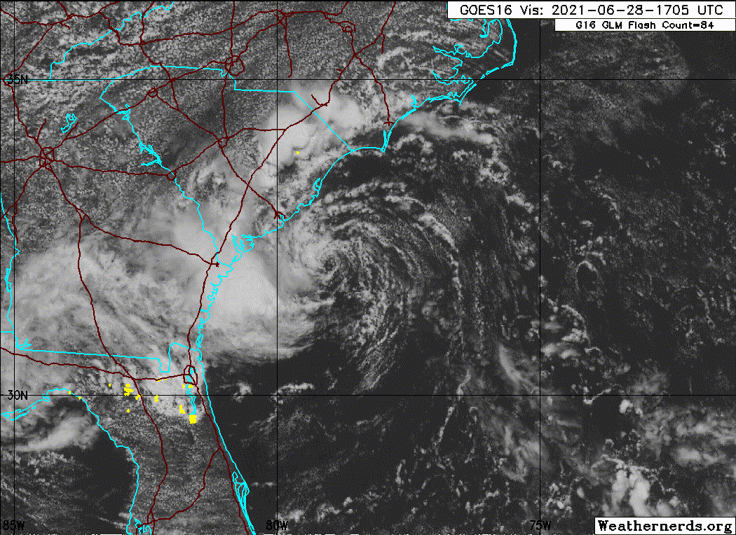
Re: ATL: DANNY - Tropical Storm - Discussion
captainbarbossa19 wrote:Ubuntwo wrote:Now up to 40kt/1009mb. I guess the NHC liked the mesovortex
By that standard, 95L should be a TS too.
95L does not have a closed surface circulation.
DANNY evidently does:

About an hour and a half away from landfall at the current motion.
Last edited by Ubuntwo on Mon Jun 28, 2021 3:55 pm, edited 1 time in total.
7 likes
Kendall -> SLO -> PBC
Memorable Storms: Katrina (for its Florida landfall...) Wilma Matthew Irma
Memorable Storms: Katrina (for its Florida landfall...) Wilma Matthew Irma
Re: ATL: DANNY - Tropical Storm - Discussion
Per radar and trends, we (SAV) look to get the heaviest rainfall from a couple of bands on the west/SW side of Danny rotating SW starting shortly and going for a couple of hours on and off. I wouldn't want to be driving then as tropical bands like this are often very heavy. It looks to be coming at a bad time, drive home time. So far, only occasional very light rain has fallen with light winds. I just heard thunder for the first time this afternoon.
3 likes
Personal Forecast Disclaimer:
The posts in this forum are NOT official forecasts and should not be used as such. They are just the opinion of the poster and may or may not be backed by sound meteorological data. They are NOT endorsed by any professional institution or storm2k.org. For official information, please refer to the NHC and NWS products.
The posts in this forum are NOT official forecasts and should not be used as such. They are just the opinion of the poster and may or may not be backed by sound meteorological data. They are NOT endorsed by any professional institution or storm2k.org. For official information, please refer to the NHC and NWS products.

Re: ATL: DANNY - Tropical Storm - Discussion
I was honestly hoping Danny would be a decent MDR storm, kind of like its 2015 version but not as strong.
0 likes
Irene '11 Sandy '12 Hermine '16 5/15/2018 Derecho Fay '20 Isaias '20 Elsa '21 Henri '21 Ida '21
I am only a meteorology enthusiast who knows a decent amount about tropical cyclones. Look to the professional mets, the NHC, or your local weather office for the best information.
I am only a meteorology enthusiast who knows a decent amount about tropical cyclones. Look to the professional mets, the NHC, or your local weather office for the best information.
Who is online
Users browsing this forum: No registered users and 9 guests