
ATL: ELSA - Models
Moderator: S2k Moderators

-
SconnieCane
- Category 5

- Posts: 1013
- Joined: Thu Aug 02, 2018 5:29 pm
- Location: Madison, WI
-
Weatherboy1

- Category 5
- Posts: 1190
- Age: 50
- Joined: Mon Jul 05, 2004 1:50 pm
- Location: Jupiter/Sarasota, FL
Re: ATL: INVEST 97L - Models
Sooooo Texas through Nova Scotia then? Glad we got that “settled”
In all seriousness, though, just underscores how far out 97 is still … and how it’s too early to nail down much!
1 likes
-
eastcoastFL

- Category 5
- Posts: 3996
- Age: 44
- Joined: Thu Apr 12, 2007 12:29 pm
- Location: Palm City, FL
Re: ATL: INVEST 97L - Models

0 likes
Personal Forecast Disclaimer:
The posts in this forum are NOT official forecast and should not be used as such. They are just the opinion of the poster and may or may not be backed by sound meteorological data. They are NOT endorsed by any professional institution or storm2k.org. For official information, please refer to the NHC and NWS products.
The posts in this forum are NOT official forecast and should not be used as such. They are just the opinion of the poster and may or may not be backed by sound meteorological data. They are NOT endorsed by any professional institution or storm2k.org. For official information, please refer to the NHC and NWS products.
-
Blown Away

- S2K Supporter

- Posts: 10253
- Joined: Wed May 26, 2004 6:17 am
Re: ATL: INVEST 97L - Models


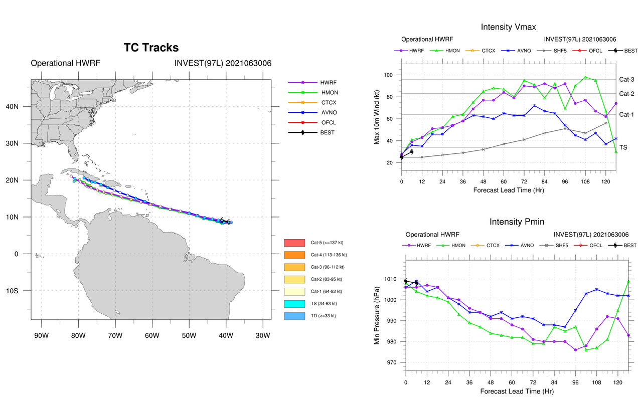
12z... Shockingly the intensity models seem to be showing a good upper air pattern down the road for 97L to become a modest Cat 1-2 hurricane and the only limiting factor appears to be the Hispaniola/Cuba land interaction... I've always been a strong believer in "Climatology" but so many rare things happening over past 10 years, like a June/July hurricane moving WNW through the MDR into the Caribbean...
1 likes
Hurricane Eye Experience: David 79, Irene 99, Frances 04, Jeanne 04, Wilma 05… Hurricane Brush Experience: Andrew 92, Erin 95, Floyd 99, Matthew 16, Irma 17, Ian 22, Nicole 22…
-
SFLcane

- S2K Supporter
- Posts: 10281
- Age: 48
- Joined: Sat Jun 05, 2010 1:44 pm
- Location: Lake Worth Florida
Re: ATL: INVEST 97L - Models
Blown Away wrote:https://i.imgur.com/2Jtx6k3.jpg
https://i.imgur.com/R49pABg.jpg
12z... Shockingly the intensity models seem to be showing a good upper air pattern down the road for 97L to become a modest Cat 1-2 hurricane and the only limiting factor appears to be the Hispaniola/Cuba land interaction... I've always been a strong believer in "Climatology" but so many rare things happening over past 10 years, like a June/July hurricane moving WNW through the MDR into the Caribbean...
I would think if this ever becomes a problem for the Florida peninsula which is highly uncertain it would need to really intensify before crossing cuba.
0 likes
Re: ATL: INVEST 97L - Models
SFLcane wrote:Blown Away wrote:https://i.imgur.com/2Jtx6k3.jpg
https://i.imgur.com/R49pABg.jpg
12z... Shockingly the intensity models seem to be showing a good upper air pattern down the road for 97L to become a modest Cat 1-2 hurricane and the only limiting factor appears to be the Hispaniola/Cuba land interaction... I've always been a strong believer in "Climatology" but so many rare things happening over past 10 years, like a June/July hurricane moving WNW through the MDR into the Caribbean...
I would think if this ever becomes a problem for the Florida peninsula which is highly uncertain it would need to really intensify before crossing cuba.
Depends which part of Cuba it crosses.. only certain sections of the island have high terrain.
0 likes
-
AutoPenalti
- Category 5
- Posts: 4091
- Age: 29
- Joined: Mon Aug 17, 2015 4:16 pm
- Location: Ft. Lauderdale, Florida
Re: ATL: INVEST 97L - Models
Cat5James wrote:SFLcane wrote:Blown Away wrote:https://i.imgur.com/2Jtx6k3.jpg
https://i.imgur.com/R49pABg.jpg
12z... Shockingly the intensity models seem to be showing a good upper air pattern down the road for 97L to become a modest Cat 1-2 hurricane and the only limiting factor appears to be the Hispaniola/Cuba land interaction... I've always been a strong believer in "Climatology" but so many rare things happening over past 10 years, like a June/July hurricane moving WNW through the MDR into the Caribbean...
I would think if this ever becomes a problem for the Florida peninsula which is highly uncertain it would need to really intensify before crossing cuba.
Depends which part of Cuba it crosses.. only certain sections of the island have high terrain.
It's mainly the SE section of the island.

1 likes
The posts in this forum are NOT official forecasts and should not be used as such. They are just the opinion of the poster and may or may not be backed by sound meteorological data. They are NOT endorsed by any professional institution or STORM2K. For official information, please refer to products from the NHC and NWS.
Model Runs Cheat Sheet:
GFS (5:30 AM/PM, 11:30 AM/PM)
HWRF, GFDL, UKMET, NAVGEM (6:30-8:00 AM/PM, 12:30-2:00 AM/PM)
ECMWF (1:45 AM/PM)
TCVN is a weighted averaged

Re: ATL: INVEST 97L - Models
06z HWRF borderline MH landfall on Jamaica. Like the 00z run it shows 97L becoming a hurricane around Friday morning and TS conditions already later today. Elsa strengthens again after the Jamaica landfall and looks to be making another cat 1 landfall on Cuba just after the run ends. The precise path is still very uncertain and climatology is definitely against future Elsa, but I have a bad feeling about this one looking at the consistency of the hurricane models. If this is already possible in late June combined with the very easy cyclogenesis of the previous tropical storms this season, who knows what'll happen once we get to August/September.


Last edited by kevin on Wed Jun 30, 2021 9:46 am, edited 2 times in total.
5 likes

Re: ATL: INVEST 97L - Models
kevin wrote:06z HWRF borderline MH landfall on Jamaica. Like the 00z run it shows 97L becoming a hurricane around Friday morning and TS conditions already later today.
A recent ASCAT pass confirmed that 97L is already producing TS-force winds, so the HWRF seems to be on to something.
4 likes
Irene '11 Sandy '12 Hermine '16 5/15/2018 Derecho Fay '20 Isaias '20 Elsa '21 Henri '21 Ida '21
I am only a meteorology enthusiast who knows a decent amount about tropical cyclones. Look to the professional mets, the NHC, or your local weather office for the best information.
I am only a meteorology enthusiast who knows a decent amount about tropical cyclones. Look to the professional mets, the NHC, or your local weather office for the best information.
-
crownweather

- S2K Supporter
- Posts: 602
- Age: 51
- Joined: Sat Aug 12, 2006 9:21 am
- Location: Sturbridge, Massachusetts
- Contact:
Re: ATL: INVEST 97L - Models
Interesting stats that ***could*** be useful for this season. GFS did best with track and HWRF did best with intensity in 2020.
https://twitter.com/pppapin/status/1410244561545269259
https://twitter.com/pppapin/status/1410244561545269259
5 likes
Rob Lightbown
Crown Weather Services
https://crownweather.com
Crown Weather Services
https://crownweather.com

Re: ATL: INVEST 97L - Models
Cat5James wrote:
Anywhere from TX to the East Coast... that narrows it down.
Not really though. Look at where the cluster is on that run. Heavy number of them pointing toward Florida. A lot of this will be dependent upon that trough and how much it weakens the high over the east coast.
0 likes
Personal Forecast Disclaimer:
The posts in this forum are NOT official forecast and should not be used as such. They are just the opinion of the poster and may or may not be backed by sound meteorological data. They are NOT endorsed by any professional institution or storm2k.org. For official information, please refer to the NHC and NWS products.
The posts in this forum are NOT official forecast and should not be used as such. They are just the opinion of the poster and may or may not be backed by sound meteorological data. They are NOT endorsed by any professional institution or storm2k.org. For official information, please refer to the NHC and NWS products.
-
Shell Mound
- Category 5
- Posts: 2432
- Age: 33
- Joined: Thu Sep 07, 2017 3:39 pm
- Location: St. Petersburg, FL → Scandinavia
Re: ATL: INVEST 97L - Models
aspen wrote:kevin wrote:06z HWRF borderline MH landfall on Jamaica. Like the 00z run it shows 97L becoming a hurricane around Friday morning and TS conditions already later today.
A recent ASCAT pass confirmed that 97L is already producing TS-force winds, so the HWRF seems to be on to something.
Nevertheless, the 06Z HWRF is noticeably weaker with 97L than the 00Z run beyond forty-eight hours, so it is clearly trending toward the GEFS/EPS.
Last edited by Shell Mound on Wed Jun 30, 2021 10:05 am, edited 1 time in total.
0 likes
CVW / MiamiensisWx / Shell Mound
The posts in this forum are NOT official forecasts and should not be used as such. They are just the opinion of the poster and may or may not be backed by sound meteorological data. They are NOT endorsed by any professional institution or STORM2K. For official information, please refer to products from the NHC and NWS.
-
captainbarbossa19

- Professional-Met

- Posts: 1094
- Age: 27
- Joined: Wed Aug 21, 2019 11:09 pm
- Location: Beaumont, TX
Re: ATL: INVEST 97L - Models
Blown Away wrote:https://i.imgur.com/2Jtx6k3.jpg
https://i.imgur.com/R49pABg.jpg
12z... Shockingly the intensity models seem to be showing a good upper air pattern down the road for 97L to become a modest Cat 1-2 hurricane and the only limiting factor appears to be the Hispaniola/Cuba land interaction... I've always been a strong believer in "Climatology" but so many rare things happening over past 10 years, like a June/July hurricane moving WNW through the MDR into the Caribbean...
Since this system is really starting to develop now and conditions appear to be favorable in the Caribbean, I would not rule out the possibility of another Dennis type system. I will not be surprised if the system is much weaker, but we need to watch this closely (which I know we will).
1 likes
-
Hypercane_Kyle

- Category 5
- Posts: 3465
- Joined: Sat Mar 07, 2015 7:58 pm
- Location: Cape Canaveral, FL
Re: ATL: INVEST 97L - Models
crownweather wrote:Interesting stats that ***could*** be useful for this season. GFS did best with track and HWRF did best with intensity in 2020.
https://twitter.com/pppapin/status/1410244561545269259
This is pretty significant and something we need to consider when watching the models for 97L. Pretty damning for the Euro to falling behind the GFS like this. Still a decent model, but it's clearly struggling with its low-bias towards TC intensity and missed genesis events.
3 likes
My posts are my own personal opinion, defer to the National Hurricane Center (NHC) and other NOAA products for decision making during hurricane season.
Re: ATL: INVEST 97L - Models
Shell Mound wrote:aspen wrote:kevin wrote:06z HWRF borderline MH landfall on Jamaica. Like the 00z run it shows 97L becoming a hurricane around Friday morning and TS conditions already later today.
A recent ASCAT pass confirmed that 97L is already producing TS-force winds, so the HWRF seems to be on to something.
Nevertheless, the 06Z HWRF is noticeably weaker with 97L than the 00Z run beyond forty-eight hours, so it is clearly trending toward the GEFS/EPS.
All of the HWRF runs have peaked in the low 970s/high 960s, and that’s exactly where the 06z run falls. It’s not significantly weaker and still gets this to hurricane status in 48-60 hours.
8 likes
Irene '11 Sandy '12 Hermine '16 5/15/2018 Derecho Fay '20 Isaias '20 Elsa '21 Henri '21 Ida '21
I am only a meteorology enthusiast who knows a decent amount about tropical cyclones. Look to the professional mets, the NHC, or your local weather office for the best information.
I am only a meteorology enthusiast who knows a decent amount about tropical cyclones. Look to the professional mets, the NHC, or your local weather office for the best information.

Re: ATL: INVEST 97L - Models
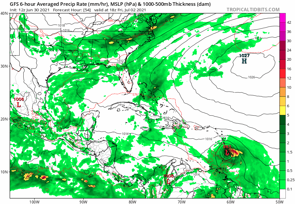
SoupBone wrote:Cat5James wrote:SFLcane wrote:06z GEFS ensembles…
...
Anywhere from TX to the East Coast... that narrows it down.
Not really though. Look at where the cluster is on that run. Heavy number of them pointing toward Florida. A lot of this will be dependent upon that trough and how much it weakens the high over the east coast.
It doesn't seem to make that much sense with the upper pattern on the operational model run. You have a front coming down and stalling out. But that brings a reaction with 97L coming up from the tropics. Seems to be the western edge of embedded Atlantic high pressure (which is embedded in more high pressure) that gives it the boundary and push to come up through Florida. MJO looks to run through Phases 2 and 3 the next few days, so we'll have to see where that's at and if the GFS evolves its 500mb forecast.
0 likes
Who is online
Users browsing this forum: No registered users and 14 guests