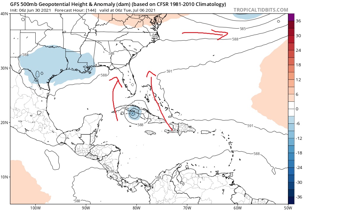
ATL: ELSA - Post-Tropical - Discussion

Moderator: S2k Moderators

Message
Author
User avatar
captainbarbossa19
Category 5
Category 5
Posts: 1081
Joined: Wed Aug 21, 2019 11:09 pm
Location: Starkville, MS (Beaumont, TX for summer)

Re: ATL: INVEST 97L - Discussion

#201 Postby captainbarbossa19 » Wed Jun 30, 2021 10:02 am

SoupBone wrote:
SFLcane wrote:Some speculation you can see the trof on the GFS swing by and weaken the ridge opening the door for 97L to eventually head north. Euro also shows the trof digging

https://i.postimg.cc/63Hf81jf/yea1.jpg


Aren't troughs digging into the south this time of year just as whacky as storms forming? Are we just getting an overall weather pattern change early this year? Seems like those puzzle pieces are fitting together nicely. That path looks like a damn October path. :lol:


I don't trust models that far out. I would not be surprised if it turns out to be a ridge instead of a trough or the trough fails to dig.
0 likes   

User avatar
ElectricStorm
Category 5
Category 5
Posts: 5017
Age: 24
Joined: Tue Aug 13, 2019 11:23 pm
Location: Skiatook, OK / Norman, OK

Re: ATL: INVEST 97L - Discussion

#202 Postby ElectricStorm » Wed Jun 30, 2021 10:03 am

Shell Mound wrote:
SFLcane wrote:Some speculation you can see the trof on the GFS swing by and weaken the ridge opening the door for 97L to eventually head north. Euro also shows the trof digging

https://i.postimg.cc/63Hf81jf/yea1.jpg

97L is likely to dissipate around 70°W, however, so I would not focus beyond the Lesser Antilles at this stage. The Windward Islands should watch closely.

I wouldn't say likely... It's possible, but if it keeps developing at the rate it is now, it could end up coming in as a strong TS maybe even a hurricane and it would be much more likely to survive. So I think people down the line do need to pay attention to it.
8 likes   
I am in no way a professional. Take what I say with a grain of salt as I could be totally wrong. Please refer to the NHC, NWS, or SPC for official information.

Boomer Sooner!

AutoPenalti
Category 5
Category 5
Posts: 4029
Age: 28
Joined: Mon Aug 17, 2015 4:16 pm
Location: Ft. Lauderdale, Florida

Re: ATL: INVEST 97L - Discussion

#203 Postby AutoPenalti » Wed Jun 30, 2021 10:04 am

Shell Mound wrote:
SFLcane wrote:Some speculation you can see the trof on the GFS swing by and weaken the ridge opening the door for 97L to eventually head north. Euro also shows the trof digging

https://i.postimg.cc/63Hf81jf/yea1.jpg

97L is likely to dissipate around 70°W, however, so I would not focus beyond the Lesser Antilles at this stage. The Windward Islands should watch closely.

I would have believed you 2 days ago, but this is highly unlikely now.
10 likes   
The posts in this forum are NOT official forecasts and should not be used as such. They are just the opinion of the poster and may or may not be backed by sound meteorological data. They are NOT endorsed by any professional institution or STORM2K. For official information, please refer to products from the NHC and NWS.


Model Runs Cheat Sheet:
GFS (5:30 AM/PM, 11:30 AM/PM)
HWRF, GFDL, UKMET, NAVGEM (6:30-8:00 AM/PM, 12:30-2:00 AM/PM)
ECMWF (1:45 AM/PM)

TCVN
is a weighted averaged

TJRE
Tropical Storm
Tropical Storm
Posts: 188
Joined: Sun Jun 02, 2013 9:04 am
Location: New Jersey

Re: ATL: INVEST 97L - Discussion

#204 Postby TJRE » Wed Jun 30, 2021 10:09 am


95l giving the SAL (dry air)
a nice break for 97l to track up into ....imho


http://tropic.ssec.wisc.edu/real-time/s ... plit&time=
Last edited by TJRE on Wed Jun 30, 2021 10:10 am, edited 1 time in total.
7 likes   

Aric Dunn
Category 5
Category 5
Posts: 21238
Age: 42
Joined: Sun Sep 19, 2004 9:58 pm
Location: Ready for the Chase.
Contact:

Re: ATL: INVEST 97L - Discussion

#205 Postby Aric Dunn » Wed Jun 30, 2021 10:09 am

Shell Mound wrote:
SFLcane wrote:Some speculation you can see the trof on the GFS swing by and weaken the ridge opening the door for 97L to eventually head north. Euro also shows the trof digging

https://i.postimg.cc/63Hf81jf/yea1.jpg

97L is likely to dissipate around 70°W, however, so I would not focus beyond the Lesser Antilles at this stage. The Windward Islands should watch closely.


No
9 likes   
Note: If I make a post that is brief. Please refer back to previous posts for the analysis or reasoning. I do not re-write/qoute what my initial post said each time.
If there is nothing before... then just ask :)

Space & Atmospheric Physicist, Embry-Riddle Aeronautical University,
I believe the sky is falling...

User avatar
Category5Kaiju
Category 5
Category 5
Posts: 4051
Joined: Thu Dec 24, 2020 12:45 pm
Location: Seattle

Re: ATL: INVEST 97L - Discussion

#206 Postby Category5Kaiju » Wed Jun 30, 2021 10:12 am

Shell Mound wrote:
SFLcane wrote:Some speculation you can see the trof on the GFS swing by and weaken the ridge opening the door for 97L to eventually head north. Euro also shows the trof digging

https://i.postimg.cc/63Hf81jf/yea1.jpg

97L is likely to dissipate around 70°W, however, so I would not focus beyond the Lesser Antilles at this stage. The Windward Islands should watch closely.


Unfortunately I am not exactly sure why it would dissipate there, especially based on looking at the current behavior of the system. I mean, it might, but what specific, concrete evidence do we have that would suggest that?
8 likes   
Unless explicitly stated, all info in my posts is based on my own opinions and observations. Tropical storms and hurricanes can be extremely dangerous. Do not think you can beat Mother Nature. Refer to an accredited weather research agency or meteorologist if you need to make serious decisions regarding an approaching storm.

User avatar
Ubuntwo
Category 5
Category 5
Posts: 1401
Age: 31
Joined: Thu Oct 05, 2017 10:41 pm

Re: ATL: INVEST 97L - Discussion

#207 Postby Ubuntwo » Wed Jun 30, 2021 10:12 am

Shell Mound wrote:
SFLcane wrote:Some speculation you can see the trof on the GFS swing by and weaken the ridge opening the door for 97L to eventually head north. Euro also shows the trof digging

https://i.postimg.cc/63Hf81jf/yea1.jpg

97L is likely to dissipate around 70°W, however, so I would not focus beyond the Lesser Antilles at this stage. The Windward Islands should watch closely.

It's definitely possible that interaction with Hispaniola completely kills off 97L without any reformations down the road. That's just one solution and certainly not 'likely' when considering model guidance as a whole. Two cents. The GFS, UKMet, CMC, Navy, HWRF, HMON, and HAFS all continue the system beyond 70W.
5 likes   
Kendall -> SLO -> PBC

Memorable Storms: Katrina (for its Florida landfall...) Wilma Matthew Irma

User avatar
SFLcane
S2K Supporter
S2K Supporter
Posts: 10162
Age: 47
Joined: Sat Jun 05, 2010 1:44 pm
Location: Lake Worth Florida

Re: ATL: INVEST 97L - Discussion

#208 Postby SFLcane » Wed Jun 30, 2021 10:12 am

Shell Mound wrote:
SFLcane wrote:Some speculation you can see the trof on the GFS swing by and weaken the ridge opening the door for 97L to eventually head north. Euro also shows the trof digging

https://i.postimg.cc/63Hf81jf/yea1.jpg

97L is likely to dissipate around 70°W, however, so I would not focus beyond the Lesser Antilles at this stage. The Windward Islands should watch closely.


We can speculate and discuss the invest and potential threats down the road. Thank you

Season is over :roll:
3 likes   

User avatar
DestinHurricane
Category 4
Category 4
Posts: 935
Joined: Tue May 01, 2018 8:05 am
Location: New York, NY

Re: ATL: INVEST 97L - Discussion

#209 Postby DestinHurricane » Wed Jun 30, 2021 10:14 am

This reminds me so much of Dennis 2005. I don't think it will get that strong, but I think the track will be very similar. @gums @ivanhater this could be one to watch
0 likes   
Michael 2018

SunnyThoughts
Category 5
Category 5
Posts: 2263
Joined: Wed Jul 09, 2003 12:42 pm
Location: Pensacola, Florida

Re: ATL: INVEST 97L - Discussion

#210 Postby SunnyThoughts » Wed Jun 30, 2021 10:16 am

DestinHurricane wrote:This reminds me so much of Dennis 2005. I don't think it will get that strong, but I think the track will be very similar. @gums @ivanhater this could be one to watch


I certainly hope that isn't the case. Dennis did a number on the trees on my property.
0 likes   

Aric Dunn
Category 5
Category 5
Posts: 21238
Age: 42
Joined: Sun Sep 19, 2004 9:58 pm
Location: Ready for the Chase.
Contact:

Re: ATL: INVEST 97L - Discussion

#211 Postby Aric Dunn » Wed Jun 30, 2021 10:16 am

ASCAT-C after after ASCAT-B

Much more uniform. still quite a bit of ambiguity. Very very close to designation..

Since the time of this pass the structure in the low levels and the convective pattern have continued to improve. Just a little more convection and an Upgrade may come 5pm/11pm

Image
5 likes   
Note: If I make a post that is brief. Please refer back to previous posts for the analysis or reasoning. I do not re-write/qoute what my initial post said each time.
If there is nothing before... then just ask :)

Space & Atmospheric Physicist, Embry-Riddle Aeronautical University,
I believe the sky is falling...

User avatar
captainbarbossa19
Category 5
Category 5
Posts: 1081
Joined: Wed Aug 21, 2019 11:09 pm
Location: Starkville, MS (Beaumont, TX for summer)

Re: ATL: INVEST 97L - Discussion

#212 Postby captainbarbossa19 » Wed Jun 30, 2021 10:16 am

Ubuntwo wrote:
Shell Mound wrote:
SFLcane wrote:Some speculation you can see the trof on the GFS swing by and weaken the ridge opening the door for 97L to eventually head north. Euro also shows the trof digging

https://i.postimg.cc/63Hf81jf/yea1.jpg

97L is likely to dissipate around 70°W, however, so I would not focus beyond the Lesser Antilles at this stage. The Windward Islands should watch closely.

It's definitely possible that interaction with Hispaniola completely kills off 97L without any reformations down the road. That's just one solution and certainly not 'likely' when considering model guidance as a whole. Two cents. The GFS, UKMet, CMC, Navy, HWRF, HMON, and HAFS all continue the system beyond 70W.


I would not even count of Hispaniola killing the storm. Remember what happened last year with Laura?
3 likes   

Shell Mound
Category 5
Category 5
Posts: 2434
Age: 32
Joined: Thu Sep 07, 2017 3:39 pm
Location: St. Petersburg, FL → Scandinavia

Re: ATL: INVEST 97L - Discussion

#213 Postby Shell Mound » Wed Jun 30, 2021 10:17 am

Ubuntwo wrote:
Shell Mound wrote:
SFLcane wrote:Some speculation you can see the trof on the GFS swing by and weaken the ridge opening the door for 97L to eventually head north. Euro also shows the trof digging

https://i.postimg.cc/63Hf81jf/yea1.jpg

97L is likely to dissipate around 70°W, however, so I would not focus beyond the Lesser Antilles at this stage. The Windward Islands should watch closely.

It's definitely possible that interaction with Hispaniola completely kills off 97L without any reformations down the road. That's just one solution and certainly not 'likely' when considering model guidance as a whole. Two cents. The GFS, UKMet, CMC, Navy, HWRF, HMON, and HAFS all continue the system beyond 70W.

I am mainly relying on the EPS. While it tends to miss genesis, it is adept at diagnosing the time of dissipation, especially in somewhat marginal setups. In this case I think the combination of interaction with land and climatologically enhanced easterlies will act to destroy the circulation to the immediate south of Hispaniola. Even now, the fact that the centre appears to be consolidating on the northern side of the convective mass suggests that proximity to the dry trade inversion will be a problem within the next two to three days. As soon as this leaves the ITCZ it could fall apart very quickly. Yet we shall see.
1 likes   
CVW / MiamiensisWx / Shell Mound
The posts in this forum are NOT official forecasts and should not be used as such. They are just the opinion of the poster and may or may not be backed by sound meteorological data. They are NOT endorsed by any professional institution or STORM2K. For official information, please refer to products from the NHC and NWS.

User avatar
InfernoFlameCat
Category 5
Category 5
Posts: 2102
Age: 22
Joined: Mon Dec 14, 2020 10:52 am
Location: Buford, GA

Re: ATL: INVEST 97L - Discussion

#214 Postby InfernoFlameCat » Wed Jun 30, 2021 10:20 am

In my eyes, the reason 97L is unlikely to dissipate in the Caribbean is because 95L is over there changing it into a quite favorable environment ie more moisture, less shear, and sucking up the dust and dry air like a vacuum.
Last edited by InfernoFlameCat on Wed Jun 30, 2021 10:20 am, edited 1 time in total.
3 likes   
I am by no means a professional. DO NOT look at my forecasts for official information or make decisions based on what I post.

Goal: to become a registered expert over tropical and subtropical cyclones.

User avatar
captainbarbossa19
Category 5
Category 5
Posts: 1081
Joined: Wed Aug 21, 2019 11:09 pm
Location: Starkville, MS (Beaumont, TX for summer)

Re: ATL: INVEST 97L - Discussion

#215 Postby captainbarbossa19 » Wed Jun 30, 2021 10:20 am

Shell Mound wrote:
Ubuntwo wrote:
Shell Mound wrote:97L is likely to dissipate around 70°W, however, so I would not focus beyond the Lesser Antilles at this stage. The Windward Islands should watch closely.

It's definitely possible that interaction with Hispaniola completely kills off 97L without any reformations down the road. That's just one solution and certainly not 'likely' when considering model guidance as a whole. Two cents. The GFS, UKMet, CMC, Navy, HWRF, HMON, and HAFS all continue the system beyond 70W.

I am mainly relying on the EPS. While it tends to miss genesis, it is adept at diagnosing the time of dissipation, especially in somewhat marginal setups. In this case I think the combination of interaction with land and climatologically enhanced easterlies will act to destroy the circulation to the immediate south of Hispaniola. Even now, the fact that the centre appears to be consolidating on the northern side of the convective mass suggests that proximity to the dry trade inversion will be a problem within the next two to three days. As soon as this leaves the ITCZ it could fall apart very quickly. Yet we shall see.


Those are valid points. Climatology would suggest that this storm will either not survive or perform well. We shall see if this pattern is an anomaly, or if climatology will win in this battle.
0 likes   

User avatar
AdamFirst
S2K Supporter
S2K Supporter
Posts: 2491
Age: 36
Joined: Thu Aug 14, 2008 10:54 am
Location: Port Saint Lucie, FL

Re: ATL: INVEST 97L - Discussion

#216 Postby AdamFirst » Wed Jun 30, 2021 10:21 am

NWS Melbourne acknowledges this system on their morning disco

Monday-Tuesday...While the eastern CONUS trough lifts out over the
NW Atlantic, a lingering weakness in the mid level height field will
persist over the SE CONUS. A strong mid level ridge is progged to
build over the western Atlantic east of Florida, coincident with a
tropical disturbance (currently Atlantic Invest 97L) moving WNW to
NW near the Greater Antilles. This system will have the potential to
impact the local weather early next week, in whatever form it takes.
However, given the inherent uncertainty in timing/location/intensity
of whatever it between now and days 6-7, it`s too soon to speculate
about impacts beyond stating the forecast will obviously maintain
above normal rain chances Mon-Tue.

Residents and visitors should keep close tabs on it over the next
several days. Now is an excellent time to ensure your seasonal
hurricane preparedness plan and supply kit is up to date!
0 likes   
Dolphins Marlins Canes Golden Panthers HEAT
Andrew 1992 - Irene 1999 - Frances 2004 - Jeanne 2004 - Wilma 2005 - Fay 2008 - Isaac 2012 - Matthew 2016 - Irma 2017 - Dorian 2019 - Ian 2022 - Nicole 2022 - Milton 2024

User avatar
InfernoFlameCat
Category 5
Category 5
Posts: 2102
Age: 22
Joined: Mon Dec 14, 2020 10:52 am
Location: Buford, GA

Re: ATL: INVEST 97L - Discussion

#217 Postby InfernoFlameCat » Wed Jun 30, 2021 10:31 am

I find it neat how much 95L is aiding 97L. These types of interactions are for some reason heartwarming to me lol. I’m going to search up major hurricanes that had a disturbance in front of it. Maybe give some insight into that. If y’all know of any scenarios in the past of this, post about it. Then we can draw comparisons between them and the current event and maybe get a better understanding on how much 95L will impact the intensity of 97L. Thanks! Also one note off the top of my head is Delta from last year had Gamma moisten things up, might be partly why Delta had such a massive RI phase.
Last edited by InfernoFlameCat on Wed Jun 30, 2021 10:32 am, edited 1 time in total.
8 likes   
I am by no means a professional. DO NOT look at my forecasts for official information or make decisions based on what I post.

Goal: to become a registered expert over tropical and subtropical cyclones.

AlphaToOmega
Category 5
Category 5
Posts: 1448
Joined: Sat Jun 26, 2021 10:51 am
Location: Somewhere in Massachusetts

Re: ATL: INVEST 97L - Discussion

#218 Postby AlphaToOmega » Wed Jun 30, 2021 10:31 am

Unlike with Invest 95L, I do not think the calendar date will be enough to stop Invest 97L from developing. Invest 95L is "sucking up" that dry air coming from Africa, putting Invest 97L in a favorable environment for cyclogenesis. Invest 97L is also farther south than Invest 95L, meaning it will have warmer waters to play with.
1 likes   

User avatar
eastcoastFL
Category 5
Category 5
Posts: 3900
Age: 43
Joined: Thu Apr 12, 2007 12:29 pm
Location: Palm City, FL

Re: ATL: INVEST 97L - Discussion

#219 Postby eastcoastFL » Wed Jun 30, 2021 10:33 am

Shell Mound wrote:
SFLcane wrote:Some speculation you can see the trof on the GFS swing by and weaken the ridge opening the door for 97L to eventually head north. Euro also shows the trof digging

https://i.postimg.cc/63Hf81jf/yea1.jpg

97L is likely to dissipate around 70°W, however, so I would not focus beyond the Lesser Antilles at this stage. The Windward Islands should watch closely.


I think it’s a bit early to say “likely” to dissipate. There’s still too many factors at this point.
0 likes   
Personal Forecast Disclaimer:
The posts in this forum are NOT official forecast and should not be used as such. They are just the opinion of the poster and may or may not be backed by sound meteorological data. They are NOT endorsed by any professional institution or storm2k.org. For official information, please refer to the NHC and NWS products.

User avatar
SFLcane
S2K Supporter
S2K Supporter
Posts: 10162
Age: 47
Joined: Sat Jun 05, 2010 1:44 pm
Location: Lake Worth Florida

Re: ATL: INVEST 97L - Discussion

#220 Postby SFLcane » Wed Jun 30, 2021 10:35 am

This is a developing tropical cyclone folks. Not to far from being classified

Image
14 likes   


Return to “2021”

Who is online

Users browsing this forum: No registered users and 25 guests