ATL: ELSA - Post-Tropical - Discussion

Moderator: S2k Moderators

Message
Author
User avatar
captainbarbossa19
Professional-Met
Professional-Met
Posts: 1092
Age: 27
Joined: Wed Aug 21, 2019 11:09 pm
Location: Beaumont, TX

Re: ATL: INVEST 97L - Discussion

#341 Postby captainbarbossa19 » Wed Jun 30, 2021 3:17 pm

wxman57 wrote:Remember Gonzalo last year? Models (and NHC) forecasting it to cross in the Caribbean as a hurricane, but it dissipated as it reached the islands. A model forecast of a strong storm by the GFS is no guarantee it will be a strong storm. No guarantee it will survive the strong easterly tradewinds in the eastern Caribbean.


Hopefully this will be more like Gonzalo and less like Dennis.
0 likes   

User avatar
SFLcane
S2K Supporter
S2K Supporter
Posts: 10163
Age: 47
Joined: Sat Jun 05, 2010 1:44 pm
Location: Lake Worth Florida

Re: ATL: INVEST 97L - Discussion

#342 Postby SFLcane » Wed Jun 30, 2021 3:18 pm

Last edited by SFLcane on Wed Jun 30, 2021 3:18 pm, edited 2 times in total.
10 likes   

User avatar
aspen
Category 5
Category 5
Posts: 8818
Joined: Sat Oct 12, 2019 7:10 pm
Location: Connecticut, USA

Re: ATL: INVEST 97L - Discussion

#343 Postby aspen » Wed Jun 30, 2021 3:18 pm

The NHC is, for some reason, going with PTC-5 instead of a TC. We’ll have to wait until post-season analysis for a June 30th upgrade, apparently.
10 likes   
Irene '11 Sandy '12 Hermine '16 5/15/2018 Derecho Fay '20 Isaias '20 Elsa '21 Henri '21 Ida '21

I am only a meteorology enthusiast who knows a decent amount about tropical cyclones. Look to the professional mets, the NHC, or your local weather office for the best information.

User avatar
InfernoFlameCat
Category 5
Category 5
Posts: 2102
Age: 22
Joined: Mon Dec 14, 2020 10:52 am
Location: Buford, GA

Re: ATL: INVEST 97L - Discussion

#344 Postby InfernoFlameCat » Wed Jun 30, 2021 3:19 pm

wxman57 wrote:
AlphaToOmega wrote:
wxman57 wrote:Remember Gonzalo last year? Models (and NHC) forecasting it to cross in the Caribbean as a hurricane, but it dissipated as it reached the islands. A model forecast of a strong storm by the GFS is no guarantee it will be a strong storm. No guarantee it will survive the strong easterly tradewinds in the eastern Caribbean.

What did HWRF say about Gonzalo (2020)?


I'm fairly sure it strengthened it into a hurricane in the eastern Caribbean. Somehow, I lost my folder of 2020 data, including the HWRF plots, though.

Slightly unrelated topic but did you badmouth Harvey? It came straight for you after dying in the Caribbean. Don’t make Elsa mad :cheesy: :cheesy: :cheesy:
4 likes   
I am by no means a professional. DO NOT look at my forecasts for official information or make decisions based on what I post.

Goal: to become a registered expert over tropical and subtropical cyclones.

User avatar
Iceresistance
Category 5
Category 5
Posts: 9288
Age: 21
Joined: Sat Oct 10, 2020 9:45 am
Location: Tecumseh, OK/Norman, OK

Re: ATL: INVEST 97L - Discussion

#345 Postby Iceresistance » Wed Jun 30, 2021 3:19 pm


How much did 2020 have up until June 30th?
Last edited by Iceresistance on Wed Jun 30, 2021 3:24 pm, edited 1 time in total.
0 likes   
Bill 2015 & Beta 2020

Winter 2020-2021 :cold:

All observations are in Tecumseh, OK unless otherwise noted.

Winter posts are focused mainly for Oklahoma & Texas.

Take any of my forecasts with a grain of salt, refer to the NWS, SPC, and NHC for official information

Never say Never with weather! Because ANYTHING is possible!

User avatar
InfernoFlameCat
Category 5
Category 5
Posts: 2102
Age: 22
Joined: Mon Dec 14, 2020 10:52 am
Location: Buford, GA

Re: ATL: INVEST 97L - Discussion

#346 Postby InfernoFlameCat » Wed Jun 30, 2021 3:20 pm

aspen wrote:The NHC is, for some reason, going with PTC-5 instead of a TC. We’ll have to wait until post-season analysis for a June 30th upgrade, apparently.

Wait because EDT still is in June right? Unless they don’t upgrade then
0 likes   
I am by no means a professional. DO NOT look at my forecasts for official information or make decisions based on what I post.

Goal: to become a registered expert over tropical and subtropical cyclones.

User avatar
captainbarbossa19
Professional-Met
Professional-Met
Posts: 1092
Age: 27
Joined: Wed Aug 21, 2019 11:09 pm
Location: Beaumont, TX

Re: ATL: INVEST 97L - Discussion

#347 Postby captainbarbossa19 » Wed Jun 30, 2021 3:20 pm

aspen wrote:The NHC is, for some reason, going with PTC-5 instead of a TC. We’ll have to wait until post-season analysis for a June 30th upgrade, apparently.


Honestly, I thought that they might call it a depression. It seems like most think that this has enough organization to be upgraded to at least that.
0 likes   

User avatar
ElectricStorm
Category 5
Category 5
Posts: 5044
Age: 24
Joined: Tue Aug 13, 2019 11:23 pm
Location: Skiatook, OK / Norman, OK

Re: ATL: INVEST 97L - Discussion

#348 Postby ElectricStorm » Wed Jun 30, 2021 3:21 pm

InfernoFlameCat wrote:
aspen wrote:The NHC is, for some reason, going with PTC-5 instead of a TC. We’ll have to wait until post-season analysis for a June 30th upgrade, apparently.

Wait because EDT still is in June right? Unless they don’t upgrade then

7 pm CDT (8pm EDT) is 0z, so unless they upgrade at the next advisory, then it will be a July named storm
2 likes   
B.S Meteorology, University of Oklahoma '25

Please refer to the NHC, NWS, or SPC for official information.

AutoPenalti
Category 5
Category 5
Posts: 4030
Age: 29
Joined: Mon Aug 17, 2015 4:16 pm
Location: Ft. Lauderdale, Florida

Re: ATL: INVEST 97L - Discussion

#349 Postby AutoPenalti » Wed Jun 30, 2021 3:27 pm

wxman57 wrote:
AlphaToOmega wrote:
wxman57 wrote:Remember Gonzalo last year? Models (and NHC) forecasting it to cross in the Caribbean as a hurricane, but it dissipated as it reached the islands. A model forecast of a strong storm by the GFS is no guarantee it will be a strong storm. No guarantee it will survive the strong easterly tradewinds in the eastern Caribbean.

What did HWRF say about Gonzalo (2020)?


I'm fairly sure it strengthened it into a hurricane in the eastern Caribbean. Somehow, I lost my folder of 2020 data, including the HWRF plots, though.

viewtopic.php?f=90&t=121022&start=20

GFS-P won that model war. Dry air and shear prevented any sort of intensification with Gonzalo.
0 likes   
The posts in this forum are NOT official forecasts and should not be used as such. They are just the opinion of the poster and may or may not be backed by sound meteorological data. They are NOT endorsed by any professional institution or STORM2K. For official information, please refer to products from the NHC and NWS.


Model Runs Cheat Sheet:
GFS (5:30 AM/PM, 11:30 AM/PM)
HWRF, GFDL, UKMET, NAVGEM (6:30-8:00 AM/PM, 12:30-2:00 AM/PM)
ECMWF (1:45 AM/PM)

TCVN
is a weighted averaged

User avatar
InfernoFlameCat
Category 5
Category 5
Posts: 2102
Age: 22
Joined: Mon Dec 14, 2020 10:52 am
Location: Buford, GA

Re: ATL: FIVE - Potential Tropical Cyclone - Discussion

#350 Postby InfernoFlameCat » Wed Jun 30, 2021 3:29 pm

On a broader note, if 2021 usurps 2020 in named storms…
Elsa started it so blame her.
1 likes   
I am by no means a professional. DO NOT look at my forecasts for official information or make decisions based on what I post.

Goal: to become a registered expert over tropical and subtropical cyclones.

Sciencerocks
Category 5
Category 5
Posts: 9155
Age: 39
Joined: Thu Jul 06, 2017 1:51 am

Re: ATL: FIVE - Potential Tropical Cyclone - Discussion

#351 Postby Sciencerocks » Wed Jun 30, 2021 3:31 pm

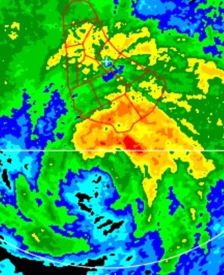
Image
7 likes   

Aric Dunn
Category 5
Category 5
Posts: 21238
Age: 42
Joined: Sun Sep 19, 2004 9:58 pm
Location: Ready for the Chase.
Contact:

Re: ATL: FIVE - Potential Tropical Cyclone - Discussion

#352 Postby Aric Dunn » Wed Jun 30, 2021 3:31 pm

The way the convection is popping now.. by 11pm I don't think they will have much choice. even if they don't get a good ASCAT pass.
9 likes   
Note: If I make a post that is brief. Please refer back to previous posts for the analysis or reasoning. I do not re-write/qoute what my initial post said each time.
If there is nothing before... then just ask :)

Space & Atmospheric Physicist, Embry-Riddle Aeronautical University,
I believe the sky is falling...

AlphaToOmega
Category 5
Category 5
Posts: 1448
Joined: Sat Jun 26, 2021 10:51 am
Location: Somewhere in Massachusetts

Re: ATL: FIVE - Potential Tropical Cyclone - Discussion

#353 Postby AlphaToOmega » Wed Jun 30, 2021 3:31 pm

wxman57 wrote:
AlphaToOmega wrote:
wxman57 wrote:Remember Gonzalo last year? Models (and NHC) forecasting it to cross in the Caribbean as a hurricane, but it dissipated as it reached the islands. A model forecast of a strong storm by the GFS is no guarantee it will be a strong storm. No guarantee it will survive the strong easterly tradewinds in the eastern Caribbean.

What did HWRF say about Gonzalo (2020)?


I'm fairly sure it strengthened it into a hurricane in the eastern Caribbean. Somehow, I lost my folder of 2020 data, including the HWRF plots, though.

I found the strongest HWRF model run for Gonzalo (2020) I could find here. It was a 965 mb hurricane with maximum wind speeds of 102 knots. I would translate that to ~90 knots. The latest HWRF run has this intensifying to 954 mb with maximum wind speeds of 137 knots. I would translate that to ~120 knots. Clearly, HWRF is much more bullish with this system than with Gonzalo (2020).
Last edited by AlphaToOmega on Wed Jun 30, 2021 3:34 pm, edited 1 time in total.
2 likes   

User avatar
AJC3
Admin
Admin
Posts: 3999
Age: 61
Joined: Tue Aug 31, 2004 7:04 pm
Location: Ballston Spa, New York
Contact:

Re: ATL: INVEST 97L - Discussion

#354 Postby AJC3 » Wed Jun 30, 2021 3:32 pm

aspen wrote:The NHC is, for some reason, going with PTC-5 instead of a TC. We’ll have to wait until post-season analysis for a June 30th upgrade, apparently.


As I'm sure you'll see them mention in the TCD, the system has lacked a well-defined, closed LLCC. This is readily apparent in the several scatterometer passes that have been posted today - in particular the METOP-C pass from 1247Z. Is it possible that the center has closed off since then? Perhaps. However it's fast forward speed may still be keeping this an open wave. To start speculating about a post season upgrade, before the initial advisory has even been sent, is quite premature. If there's no solid evidence that the system has become closed off/well defined, then any speculative post-season upgrade likely isn't going to change that (in absence of say, a late-arriving ship report).

If they don't decide to call it a TC at 5 or 11 PM, then there's a strong likelhood that it won't be post-analyzed as such either.
6 likes   

Nuno
Category 2
Category 2
Posts: 597
Joined: Fri Aug 30, 2019 8:35 am
Location: Coral Gables, FL

Re: ATL: INVEST 97L - Discussion

#355 Postby Nuno » Wed Jun 30, 2021 3:32 pm

AlphaToOmega wrote:
wxman57 wrote:
AlphaToOmega wrote:What did HWRF say about Gonzalo (2020)?


I'm fairly sure it strengthened it into a hurricane in the eastern Caribbean. Somehow, I lost my folder of 2020 data, including the HWRF plots, though.

I found the strongest HWRF model run for Gonzalo (2020) I could find here. It was a 965 mb hurricane with maximum wind speeds of 102 knots. I would translate that to ~90 knots. The latest HWRF run has this intensifying to 954 mb with maximum wind speeds of 137 knots. I would translate that to ~120 knots. Clearly, HWRF is much more bullish with this system than with Gonzalo (2020).


Also, proto-Elsa will face much less shear than Gonzalo.
1 likes   
Andrew (1992), Irene (1999), Frances (2004), Katrina (2005), Wilma (2005), Fay (2008), Irma (2017), Eta (2020), Ian (2022)

User avatar
Stormybajan
Category 1
Category 1
Posts: 448
Joined: Thu May 20, 2021 3:21 pm
Location: Windward Islands

Re: ATL: FIVE - Potential Tropical Cyclone - Discussion

#356 Postby Stormybajan » Wed Jun 30, 2021 3:35 pm


This is definitely the most impressive june MDR system I can remember...I expect tropical storm watches to be placed for Dominica all the way down to Grenada..the water only gets warmer from here and the OHC also increases as it goes along. PTC5 has really taken advantage of the path 95L gave it
7 likes   
Sad West Indies and Manchester United fan ⚽️

User avatar
presidentofyes12
Tropical Low
Tropical Low
Posts: 27
Joined: Sat Jun 19, 2021 6:16 am

Re: ATL: FIVE - Potential Tropical Cyclone - Discussion

#357 Postby presidentofyes12 » Wed Jun 30, 2021 3:39 pm

Image
Here's a simulated IR satellite forecast from the HWRF model. It's wind speeds here are about 128 mph.
1 likes   
the above message may be based on reliable weather information, but is not itself reliable weather information. see the national weather service or the national hurricane center for official info.

User avatar
eastcoastFL
Category 5
Category 5
Posts: 3901
Age: 43
Joined: Thu Apr 12, 2007 12:29 pm
Location: Palm City, FL

Re: ATL: FIVE - Potential Tropical Cyclone - Discussion

#358 Postby eastcoastFL » Wed Jun 30, 2021 3:41 pm

presidentofyes12 wrote:https://pipe.miroware.io/5ea73c85ba35b8055638eb96/hwrf_satIR_97L_21.png
Here's a simulated IR satellite forecast from the HWRF model. It's wind speeds here are about 128 mph.


It’s usually pretty close with it’s prediction of IR presentation. But that will depend on land interaction down the line. I am interested in what it depicts for the next 24-48 hours because that should be pretty accurate
0 likes   
Personal Forecast Disclaimer:
The posts in this forum are NOT official forecast and should not be used as such. They are just the opinion of the poster and may or may not be backed by sound meteorological data. They are NOT endorsed by any professional institution or storm2k.org. For official information, please refer to the NHC and NWS products.

User avatar
Iceresistance
Category 5
Category 5
Posts: 9288
Age: 21
Joined: Sat Oct 10, 2020 9:45 am
Location: Tecumseh, OK/Norman, OK

Re: ATL: FIVE - Potential Tropical Cyclone - Discussion

#359 Postby Iceresistance » Wed Jun 30, 2021 3:42 pm

presidentofyes12 wrote:https://pipe.miroware.io/5ea73c85ba35b8055638eb96/hwrf_satIR_97L_21.png
Here's a simulated IR satellite forecast from the HWRF model. It's wind speeds here are about 128 mph.


Oh my, that is close to how strong Dennis was in 2005!
3 likes   
Bill 2015 & Beta 2020

Winter 2020-2021 :cold:

All observations are in Tecumseh, OK unless otherwise noted.

Winter posts are focused mainly for Oklahoma & Texas.

Take any of my forecasts with a grain of salt, refer to the NWS, SPC, and NHC for official information

Never say Never with weather! Because ANYTHING is possible!

User avatar
StPeteMike
Category 2
Category 2
Posts: 631
Joined: Thu Jun 07, 2018 11:26 pm

Re: ATL: FIVE - Potential Tropical Cyclone - Discussion

#360 Postby StPeteMike » Wed Jun 30, 2021 3:43 pm

While on the side discussion of Gonzalo, models also had very less data from airplanes last year than now. That data would had probably helped all the models to show that the environment in the Eastern Caribbean wouldn’t be able to provide favorable conditions for such a little storm.

Future Elsa doesn’t have that issue. More data from international flights for these models to incorporate into their models. And, as mentioned, much larger storm and has 95L to clear the SAL out and provide better conditions than Gonzalo clearly had.
1 likes   
The above post is not official and should not be used as such. It is the opinion of the poster and may or may not be backed by sound meteorological data. It is not endorsed by any professional institution or storm2k.org. For official information, please refer to the NHC and NWS products.


Return to “2021”

Who is online

Users browsing this forum: No registered users and 10 guests