ATL: ELSA - Models

Moderator: S2k Moderators

Message
Author
User avatar
Kingarabian
S2K Supporter
S2K Supporter
Posts: 15979
Joined: Sat Aug 08, 2009 3:06 am
Location: Honolulu, Hawaii

Re: ATL: INVEST 97L - Models

#141 Postby Kingarabian » Wed Jun 30, 2021 2:34 pm

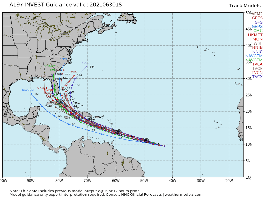
NDG wrote:Another Euro failure in the MDR.

[url]https://i.imgur.com/RfkNomH.gif[/ul]

The Euro can't initialize anything (even the CMC). It can't get initial conditions correct. Eventually, its initialization errors play a role in its predicted track and intensity.
5 likes   
RIP Kobe Bryant

User avatar
SFLcane
S2K Supporter
S2K Supporter
Posts: 10163
Age: 47
Joined: Sat Jun 05, 2010 1:44 pm
Location: Lake Worth Florida

Re: ATL: INVEST 97L - Models

#142 Postby SFLcane » Wed Jun 30, 2021 2:50 pm

Another look at the 18z guidance..

Image
5 likes   

Nuno
Category 2
Category 2
Posts: 597
Joined: Fri Aug 30, 2019 8:35 am
Location: Coral Gables, FL

Re: ATL: INVEST 97L - Models

#143 Postby Nuno » Wed Jun 30, 2021 3:09 pm


So, kind of like 2006 Ernesto?

We'll see how it pans out, not many fare well after the Antilles.
0 likes   
Andrew (1992), Irene (1999), Frances (2004), Katrina (2005), Wilma (2005), Fay (2008), Irma (2017), Eta (2020), Ian (2022)

User avatar
captainbarbossa19
Professional-Met
Professional-Met
Posts: 1092
Age: 27
Joined: Wed Aug 21, 2019 11:09 pm
Location: Beaumont, TX

Re: ATL: INVEST 97L - Models

#144 Postby captainbarbossa19 » Wed Jun 30, 2021 3:23 pm

Nuno wrote:


So, kind of like 2006 Ernesto?

We'll see how it pans out, not many fare well after the Antilles.


Somehow, I will not be surprised if this stays south of the Greater Antilles.
0 likes   

HurricaneFrances04
Category 2
Category 2
Posts: 597
Joined: Mon Jun 25, 2012 8:09 am
Location: Fort Lauderdale, Florida

Re: ATL: FIVE - Models

#145 Postby HurricaneFrances04 » Wed Jun 30, 2021 3:26 pm

Always feel like these fast moving systems go further south and west than what the models expect. I suppose we’ll get a better idea over the next 48 hours.
5 likes   

User avatar
eastcoastFL
Category 5
Category 5
Posts: 3901
Age: 43
Joined: Thu Apr 12, 2007 12:29 pm
Location: Palm City, FL

Re: ATL: FIVE - Models

#146 Postby eastcoastFL » Wed Jun 30, 2021 3:44 pm

Last year HWRF was really good at depicting future IR presentation. This is what it thinks it should look like in 18 hours. I’m interested to see if this plays out

Image
6 likes   
Personal Forecast Disclaimer:
The posts in this forum are NOT official forecast and should not be used as such. They are just the opinion of the poster and may or may not be backed by sound meteorological data. They are NOT endorsed by any professional institution or storm2k.org. For official information, please refer to the NHC and NWS products.

AutoPenalti
Category 5
Category 5
Posts: 4030
Age: 29
Joined: Mon Aug 17, 2015 4:16 pm
Location: Ft. Lauderdale, Florida

Re: ATL: FIVE - Models

#147 Postby AutoPenalti » Wed Jun 30, 2021 3:51 pm

eastcoastFL wrote:Last year HWRF was really good at depicting future IR presentation. This is what it thinks it should look like in 18 hours. I’m interested to see if this plays out

https://www.tropicaltidbits.com/analysis/models/hwrf/2021063012/hwrf_satIR_97L_4.png

Highly doubt it will look similar to this but that does not mean it will look stronger than it does now.
0 likes   
The posts in this forum are NOT official forecasts and should not be used as such. They are just the opinion of the poster and may or may not be backed by sound meteorological data. They are NOT endorsed by any professional institution or STORM2K. For official information, please refer to products from the NHC and NWS.


Model Runs Cheat Sheet:
GFS (5:30 AM/PM, 11:30 AM/PM)
HWRF, GFDL, UKMET, NAVGEM (6:30-8:00 AM/PM, 12:30-2:00 AM/PM)
ECMWF (1:45 AM/PM)

TCVN
is a weighted averaged

AxaltaRacing24
Category 5
Category 5
Posts: 1753
Age: 25
Joined: Wed Jul 27, 2016 11:14 am
Location: Jupiter, FL

Re: ATL: FIVE - Models

#148 Postby AxaltaRacing24 » Wed Jun 30, 2021 3:53 pm

AutoPenalti wrote:
eastcoastFL wrote:Last year HWRF was really good at depicting future IR presentation. This is what it thinks it should look like in 18 hours. I’m interested to see if this plays out

https://www.tropicaltidbits.com/analysis/models/hwrf/2021063012/hwrf_satIR_97L_4.png

Highly doubt it will look similar to this but that does not mean it will look stronger than it does now.

It looks more similar to that image by the minute to my eyes.
8 likes   

User avatar
johngaltfla
Category 5
Category 5
Posts: 2069
Joined: Sun Jul 10, 2005 9:17 pm
Location: Sarasota County, FL
Contact:

Re: ATL: FIVE - Models

#149 Postby johngaltfla » Wed Jun 30, 2021 4:46 pm

Interesting how the Canadian, NAVGEM, and GFS are all confident about SW Florida towards the end of the run. This time of year, that fits the pattern so I wonder if we'll see some upper air readings south of the DR and Cuba to confirm the models soon. I hope they do not stay this consistent.
0 likes   

User avatar
cainjamin
Tropical Storm
Tropical Storm
Posts: 168
Age: 34
Joined: Mon Apr 17, 2017 1:38 pm
Location: Nova Scotia, Canada

Re: ATL: FIVE - Models

#150 Postby cainjamin » Wed Jun 30, 2021 4:56 pm

12Z GFS is coming in. Slightly weaker than the 18Z through the Lesser Antilles due to what looks to be a little more shear.
0 likes   
Noel '07, Kyle '08, Earl '10, Arthur '14, Dorian '19, Teddy '20, Lee '23

AutoPenalti
Category 5
Category 5
Posts: 4030
Age: 29
Joined: Mon Aug 17, 2015 4:16 pm
Location: Ft. Lauderdale, Florida

Re: ATL: FIVE - Models

#151 Postby AutoPenalti » Wed Jun 30, 2021 5:01 pm

cainjamin wrote:12Z GFS is coming in. Slightly weaker than the 18Z through the Lesser Antilles due to what looks to be a little more shear.

You mean the 18z is running?

Looks the same through 66hrs.
0 likes   
The posts in this forum are NOT official forecasts and should not be used as such. They are just the opinion of the poster and may or may not be backed by sound meteorological data. They are NOT endorsed by any professional institution or STORM2K. For official information, please refer to products from the NHC and NWS.


Model Runs Cheat Sheet:
GFS (5:30 AM/PM, 11:30 AM/PM)
HWRF, GFDL, UKMET, NAVGEM (6:30-8:00 AM/PM, 12:30-2:00 AM/PM)
ECMWF (1:45 AM/PM)

TCVN
is a weighted averaged

User avatar
cainjamin
Tropical Storm
Tropical Storm
Posts: 168
Age: 34
Joined: Mon Apr 17, 2017 1:38 pm
Location: Nova Scotia, Canada

Re: ATL: FIVE - Models

#152 Postby cainjamin » Wed Jun 30, 2021 5:03 pm

AutoPenalti wrote:
cainjamin wrote:12Z GFS is coming in. Slightly weaker than the 18Z through the Lesser Antilles due to what looks to be a little more shear.

You mean the 18z is running?

Looks the same through 66hrs.


Whoops! Got my times reversed.
0 likes   
Noel '07, Kyle '08, Earl '10, Arthur '14, Dorian '19, Teddy '20, Lee '23

AutoPenalti
Category 5
Category 5
Posts: 4030
Age: 29
Joined: Mon Aug 17, 2015 4:16 pm
Location: Ft. Lauderdale, Florida

Re: ATL: FIVE - Models

#153 Postby AutoPenalti » Wed Jun 30, 2021 5:06 pm

GFS A LOT STRONGER at 90hr, missed the Islands, going right through the middle.
0 likes   
The posts in this forum are NOT official forecasts and should not be used as such. They are just the opinion of the poster and may or may not be backed by sound meteorological data. They are NOT endorsed by any professional institution or STORM2K. For official information, please refer to products from the NHC and NWS.


Model Runs Cheat Sheet:
GFS (5:30 AM/PM, 11:30 AM/PM)
HWRF, GFDL, UKMET, NAVGEM (6:30-8:00 AM/PM, 12:30-2:00 AM/PM)
ECMWF (1:45 AM/PM)

TCVN
is a weighted averaged

User avatar
cainjamin
Tropical Storm
Tropical Storm
Posts: 168
Age: 34
Joined: Mon Apr 17, 2017 1:38 pm
Location: Nova Scotia, Canada

Re: ATL: FIVE - Models

#154 Postby cainjamin » Wed Jun 30, 2021 5:12 pm

18Z trended a little faster and weaker through the Lesser Antilles, but then stronger as it threaded the needle between Haiti, Jamaica and Cuba. Will definitely have to keep an eye on weather or not a west trend continues.
0 likes   
Noel '07, Kyle '08, Earl '10, Arthur '14, Dorian '19, Teddy '20, Lee '23

User avatar
toad strangler
S2K Supporter
S2K Supporter
Posts: 4543
Joined: Sun Jul 28, 2013 3:09 pm
Location: Earth
Contact:

Re: ATL: FIVE - Models

#155 Postby toad strangler » Wed Jun 30, 2021 5:12 pm

Image
0 likes   

AlphaToOmega
Category 5
Category 5
Posts: 1448
Joined: Sat Jun 26, 2021 10:51 am
Location: Somewhere in Massachusetts

Re: ATL: FIVE - Models

#156 Postby AlphaToOmega » Wed Jun 30, 2021 5:13 pm

Forecasted wind shear:
Image
2005 wind shear:
Image
2005 has <10 kt of wind shear throughout the Caribbean Sea this time of year, but 2021 is forecasted to have ~20 kt of wind shear in next week.
2 likes   

User avatar
SFLcane
S2K Supporter
S2K Supporter
Posts: 10163
Age: 47
Joined: Sat Jun 05, 2010 1:44 pm
Location: Lake Worth Florida

Re: ATL: FIVE - Models

#157 Postby SFLcane » Wed Jun 30, 2021 5:14 pm

AutoPenalti wrote:GFS A LOT STRONGER at 90hr, missed the Islands, going right through the middle.


Yessir…986mb Hurricane approaching Cuba.
1 likes   

Fancy1001
Category 1
Category 1
Posts: 452
Joined: Thu Jul 16, 2020 10:16 pm

Re: ATL: FIVE - Models

#158 Postby Fancy1001 » Wed Jun 30, 2021 5:16 pm

The latest GFS was able to thread the needle, now let's see what happens after it gets off of Cuba
0 likes   

User avatar
toad strangler
S2K Supporter
S2K Supporter
Posts: 4543
Joined: Sun Jul 28, 2013 3:09 pm
Location: Earth
Contact:

Re: ATL: FIVE - Models

#159 Postby toad strangler » Wed Jun 30, 2021 5:19 pm

Hour 144 on 18z GFS Look Out & a tad W of 12Z
0 likes   

User avatar
toad strangler
S2K Supporter
S2K Supporter
Posts: 4543
Joined: Sun Jul 28, 2013 3:09 pm
Location: Earth
Contact:

Re: ATL: FIVE - Models

#160 Postby toad strangler » Wed Jun 30, 2021 5:22 pm

Perilously close to Tampa @156
0 likes   


Return to “2021”

Who is online

Users browsing this forum: No registered users and 2 guests