2021 Indicators: SST's / SAL / MSLP / Shear / Steering / Instability / Sat Images

This is the general tropical discussion area. Anyone can take their shot at predicting a storms path.

Moderator: S2k Moderators

Forum rules

The posts in this forum are NOT official forecasts and should not be used as such. They are just the opinion of the poster and may or may not be backed by sound meteorological data. They are NOT endorsed by any professional institution or STORM2K. For official information, please refer to products from the National Hurricane Center and National Weather Service.

Help Support Storm2K
Message
Author
AlphaToOmega
Category 5
Category 5
Posts: 1448
Joined: Sat Jun 26, 2021 10:51 am
Location: Somewhere in Massachusetts

Re: 2021 Indicators: SST's / SAL / MSLP / Shear / Steering / Instability / Sat Images

#861 Postby AlphaToOmega » Tue Jun 29, 2021 7:23 am

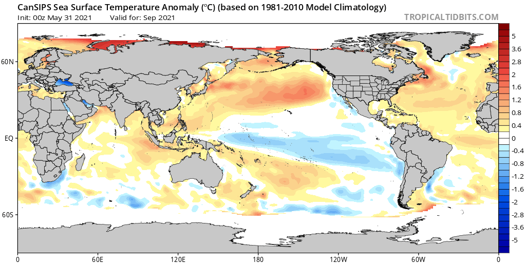
CanSIPS SST anomaly forecast:
Image

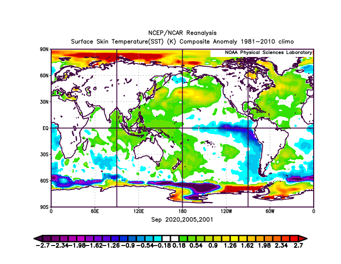
Sept 2020, 2005, and 2001 SST anomalies composite:
Image

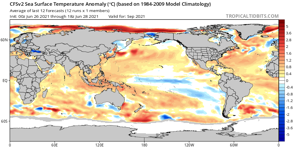
CFSv2 SST anomaly forecast:
Image

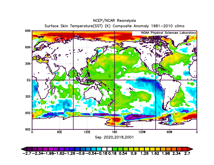
Sept 2020, 2018, and 2001 SST anomalies composite:
Image

SST anomalies tell similar stories to VP anomalies. The CanSIPS is suggesting a season in between 2020, 2005, and 2001, which would yield an ACE of ~180. The CFSv2 is suggesting a season in between 2020, 2018, and 2001, which would yield an ACE of ~140. It is never a good sign when both 2020 and 2005 are potential analogs.
8 likes   

User avatar
toad strangler
S2K Supporter
S2K Supporter
Posts: 4543
Joined: Sun Jul 28, 2013 3:09 pm
Location: Earth
Contact:

Re: 2021 Indicators: SST's / SAL / MSLP / Shear / Steering / Instability / Sat Images

#862 Postby toad strangler » Tue Jun 29, 2021 8:37 am

Almost through June and the SAL handwringing meter is at a record low decibel.
8 likes   

AlphaToOmega
Category 5
Category 5
Posts: 1448
Joined: Sat Jun 26, 2021 10:51 am
Location: Somewhere in Massachusetts

Re: 2021 Indicators: SST's / SAL / MSLP / Shear / Steering / Instability / Sat Images

#863 Postby AlphaToOmega » Tue Jun 29, 2021 8:39 am

toad strangler wrote:Almost through June and the SAL handwringing meter is at a record low decibel.

I told you: no one is going to say "season cancelled" this year! 8-)
0 likes   

User avatar
aspen
Category 5
Category 5
Posts: 8818
Joined: Sat Oct 12, 2019 7:10 pm
Location: Connecticut, USA

Re: 2021 Indicators: SST's / SAL / MSLP / Shear / Steering / Instability / Sat Images

#864 Postby aspen » Tue Jun 29, 2021 8:58 am

toad strangler wrote:Almost through June and the SAL handwringing meter is at a record low decibel.

It’s mostly been SST handwringing lol. Although I think the abnormal amount of strong June waves has helped calm the SAL handwringers by showing the MDR is already trying to form something despite June climatology.

How does this year’s SAL compare to that of other years? It’s definitely nowhere near 2020’s record SAL outbreak.
7 likes   
Irene '11 Sandy '12 Hermine '16 5/15/2018 Derecho Fay '20 Isaias '20 Elsa '21 Henri '21 Ida '21

I am only a meteorology enthusiast who knows a decent amount about tropical cyclones. Look to the professional mets, the NHC, or your local weather office for the best information.
User avatar
Category5Kaiju
Category 5
Category 5
Posts: 4097
Joined: Thu Dec 24, 2020 12:45 pm
Location: Seattle

Re: 2021 Indicators: SST's / SAL / MSLP / Shear / Steering / Instability / Sat Images

#865 Postby Category5Kaiju » Tue Jun 29, 2021 9:33 am

What's for sure if there is one thing that 2021 is doing much better at than 2020, it is that it is already producing robust waves with 2 very real candidates already for Elsa and Fred in June! 2020 definitely had that issue of a widespread SAL outbreak followed by waves clumping in the ITCZ (hence the lack of very intense, long track MDR born systems).
7 likes   
Unless explicitly stated, all info in my posts is based on my own opinions and observations. Tropical storms and hurricanes can be extremely dangerous. Do not think you can beat Mother Nature. Refer to an accredited weather research agency or meteorologist if you need to make serious decisions regarding an approaching storm.

tolakram
Admin
Admin
Posts: 20009
Age: 62
Joined: Sun Aug 27, 2006 8:23 pm
Location: Florence, KY (name is Mark)

Re: 2021 Indicators: SST's / SAL / MSLP / Shear / Steering / Instability / Sat Images

#866 Postby tolakram » Tue Jun 29, 2021 1:43 pm

I wonder what the difference is between a year where models show development in the MDR yet nothing happens, mainly because it's June, and years where models show no development?

These waves are moving too fast for development and fooling the models IMO, nevertheless the waves and potential continues. There's so many factors that go into a season that I fail to find anything that's happened so far declaratory. If these waves start to develop as conditions improve in July then I see a possibility for long tracking hurricanes. This could raise ACE, but so what? Waves that don't develop in the MDR run the risk of finding ideal conditions closer to the coast, and we know from last year that models can fail to pick up on development until just a few days out. Late developing storms can become very strong and have a major impact on the coast, but not produce very much total ACE compared to a long tracking storm. So what?

That's my input for the week. :lol: I still expect July to be dead, and maybe well into August. I have no scientific basis for that opinion.
9 likes   
M a r k
- - - - -
Join us in chat: Storm2K Chatroom Invite. Android and IOS apps also available.

The posts in this forum are NOT official forecasts and should not be used as such. Posts are NOT endorsed by any professional institution or STORM2K.org. For official information and forecasts, please refer to NHC and NWS products.

Chris90
Category 2
Category 2
Posts: 646
Age: 35
Joined: Thu Jun 01, 2017 9:36 pm

Re: 2021 Indicators: SST's / SAL / MSLP / Shear / Steering / Instability / Sat Images

#867 Postby Chris90 » Tue Jun 29, 2021 7:58 pm

aspen wrote:
toad strangler wrote:Almost through June and the SAL handwringing meter is at a record low decibel.

It’s mostly been SST handwringing lol. Although I think the abnormal amount of strong June waves has helped calm the SAL handwringers by showing the MDR is already trying to form something despite June climatology.

How does this year’s SAL compare to that of other years? It’s definitely nowhere near 2020’s record SAL outbreak.


I too want to know how this year's SAL compares to other years. In 2017, Phil Klotzbach posted a tweet showing that SAL was at the lowest level since 2005, and if I remember correctly, it was looking at African dust outbreaks in the spring, it was something like April and May I believe.

2020 obviously was not the same way, with huge dust outbreaks. It's the only time in the entire 31 years I've spent living in the Upper Midwest that we were told we might experience dust from Africa, and it inspired a flurry of regional memes about the approaching "dust storm."

Does anyone have a link to data about SAL and its varying intensity? I believe when I saw Klotzbach post about it there was a handy graph that charted it year by year.
5 likes   
Solar Aquarian
Lunar Cancerian
:uarrow: Sagittarian

User avatar
galaxy401
Category 5
Category 5
Posts: 2419
Age: 30
Joined: Sat Aug 25, 2012 9:04 pm
Location: Casa Grande, Arizona

Re: 2021 Indicators: SST's / SAL / MSLP / Shear / Steering / Instability / Sat Images

#868 Postby galaxy401 » Wed Jun 30, 2021 1:07 am

The fact we have two MDR disturbances in June with one on its way to developing is very crazy to me. Right now, these are early signs for another very active season. Even last year didn't have a very active MDR so this trend is very interesting. My opinion of course.
11 likes   
Got my eyes on moving right into Hurricane Alley: Florida.

User avatar
aspen
Category 5
Category 5
Posts: 8818
Joined: Sat Oct 12, 2019 7:10 pm
Location: Connecticut, USA

Re: 2021 Indicators: SST's / SAL / MSLP / Shear / Steering / Instability / Sat Images

#869 Postby aspen » Wed Jun 30, 2021 6:27 am

With the non-zero possibility of 97L becoming Hurricane Elsa in the first days of July, I wanted to see if the presence of a MDR or AEW-born July hurricane indicates a more active season than those with any July AEW system regardless of intensity. It turns out there actually isn’t much of a difference.

I limited my sample to seasons between 1980 and 2020, because the earlier back I go, the more seasons from the -AMO era are included, and that is not the state we are in now. This time frame allows for some of those -AMO era seasons to be included, but not the exceptionally inactive ones that were due to a totally different base state than the last 25+ years. 1985, 1989, 1990, 1995, 1996, 1998, 2003, 2004, 2005, 2008, 2010, 2011, 2013, 2017, 2018, and 2020 all had at least one system that formed in July either entirely or partially from a tropical wave (systems like Bertha ‘90 and Alex ‘04 were from an AEW combined with another source), and these are the averages I got:
—16.9 named storms
—9.0 hurricanes
—4.1 major hurricanes
—160.26 ACE

Now for the years that had a July AEW hurricane. Some of these years also had AEW tropical storms, or systems born from non-tropical precursors. The selection of seasons is cut down to 1985, 1989, 1990, 1996, 2003, 2004, 2005, 2008, 2018, and 2020, and the averages are:
—16.9 named storms
—9.2 hurricanes
—4.2 major hurricanes
—159.86 ACE

When rounded, both criteria yield the same average seasonal numbers: 17/9/4 and 160 ACE. Therefore, as I suggested in previous posts, the intensity of these July AEW systems doesn’t matter as much as the fact that any were able to form in the first place. The presence of one, on average, would indicate an active to potentially hyperactive season.

If 97L becomes Elsa today, it technically won’t count, but it’s so close to July and would mainly exist in that month so it probably should.
15 likes   
Irene '11 Sandy '12 Hermine '16 5/15/2018 Derecho Fay '20 Isaias '20 Elsa '21 Henri '21 Ida '21

I am only a meteorology enthusiast who knows a decent amount about tropical cyclones. Look to the professional mets, the NHC, or your local weather office for the best information.
User avatar
captainbarbossa19
Professional-Met
Professional-Met
Posts: 1092
Age: 27
Joined: Wed Aug 21, 2019 11:09 pm
Location: Beaumont, TX

Re: 2021 Indicators: SST's / SAL / MSLP / Shear / Steering / Instability / Sat Images

#870 Postby captainbarbossa19 » Wed Jun 30, 2021 1:42 pm

galaxy401 wrote:The fact we have two MDR disturbances in June with one on its way to developing is very crazy to me. Right now, these are early signs for another very active season. Even last year didn't have a very active MDR so this trend is very interesting. My opinion of course.


It seems like wind shear is well below normal for this time of year too. Usually, the Caribbean has 40kts+ of wind shear right now.
3 likes   

AlphaToOmega
Category 5
Category 5
Posts: 1448
Joined: Sat Jun 26, 2021 10:51 am
Location: Somewhere in Massachusetts

Re: 2021 Indicators: SST's / SAL / MSLP / Shear / Steering / Instability / Sat Images

#871 Postby AlphaToOmega » Wed Jun 30, 2021 2:42 pm

I think the 9th storm of the season is a good bellwether for activity. Based on looking at past hurricane seasons, I have noticed a pattern:
  1. If the 9th storm forms in July, the season will be very active
  2. If the 9th storm forms in August, the season will be active
  3. If the 9th storm forms in September or early October, the season will be near-average
  4. If the 9th storm forms later, the season will be below-average
This is a rule, but it is a pattern I have noticed. The earlier the 9th storm forms, the more active the season
0 likes   

User avatar
Category5Kaiju
Category 5
Category 5
Posts: 4097
Joined: Thu Dec 24, 2020 12:45 pm
Location: Seattle

Re: 2021 Indicators: SST's / SAL / MSLP / Shear / Steering / Instability / Sat Images

#872 Postby Category5Kaiju » Wed Jun 30, 2021 3:46 pm

AlphaToOmega wrote:I think the 9th storm of the season is a good bellwether for activity. Based on looking at past hurricane seasons, I have noticed a pattern:
  1. If the 9th storm forms in July, the season will be very active
  2. If the 9th storm forms in August, the season will be active
  3. If the 9th storm forms in September or early October, the season will be near-average
  4. If the 9th storm forms later, the season will be below-average
This is a rule, but it is a pattern I have noticed. The earlier the 9th storm forms, the more active the season


If you don't mind, when you mean "active," do you mean in terms of NSs, hurricanes, majors, or ACE?
0 likes   
Unless explicitly stated, all info in my posts is based on my own opinions and observations. Tropical storms and hurricanes can be extremely dangerous. Do not think you can beat Mother Nature. Refer to an accredited weather research agency or meteorologist if you need to make serious decisions regarding an approaching storm.

AlphaToOmega
Category 5
Category 5
Posts: 1448
Joined: Sat Jun 26, 2021 10:51 am
Location: Somewhere in Massachusetts

Re: 2021 Indicators: SST's / SAL / MSLP / Shear / Steering / Instability / Sat Images

#873 Postby AlphaToOmega » Wed Jun 30, 2021 3:47 pm

Category5Kaiju wrote:
AlphaToOmega wrote:I think the 9th storm of the season is a good bellwether for activity. Based on looking at past hurricane seasons, I have noticed a pattern:
  1. If the 9th storm forms in July, the season will be very active
  2. If the 9th storm forms in August, the season will be active
  3. If the 9th storm forms in September or early October, the season will be near-average
  4. If the 9th storm forms later, the season will be below-average
This is a rule, but it is a pattern I have noticed. The earlier the 9th storm forms, the more active the season


If you don't mind, when you mean "active," do you mean in terms of NSs, hurricanes, majors, or ACE?


Storms generally
0 likes   

User avatar
Hammy
Category 5
Category 5
Posts: 5849
Age: 41
Joined: Fri May 25, 2012 5:25 pm
Contact:

Re: 2021 Indicators: SST's / SAL / MSLP / Shear / Steering / Instability / Sat Images

#874 Postby Hammy » Wed Jun 30, 2021 7:24 pm

I had an interesting thought, there's a very 2013-esque pattern shaping up in the eastern US--massive digging trough with cooler temps (upper 60s to low 70s in Atlanta expected) with tropical waves coming into the southeast and Georgia getting a west to east flow ahead of this. But then looking at the deep tropics, it looks like early August and clearly the polar opposite of 2013.

It's speculation and based largely on regional conditions, but I wonder if this season may end up a sort of peek as to what 2013 might've been at it's full potential had the thermohaline problems not been present.
4 likes   
The above post is not official and should not be used as such. It is the opinion of the poster and may or may not be backed by sound meteorological data. It is not endorsed by any professional institution or storm2k.org. For official information, please refer to the NHC and NWS products.

User avatar
Category5Kaiju
Category 5
Category 5
Posts: 4097
Joined: Thu Dec 24, 2020 12:45 pm
Location: Seattle

Re: 2021 Indicators: SST's / SAL / MSLP / Shear / Steering / Instability / Sat Images

#875 Postby Category5Kaiju » Wed Jun 30, 2021 7:36 pm

Hammy wrote:I had an interesting thought, there's a very 2013-esque pattern shaping up in the eastern US--massive digging trough with cooler temps (upper 60s to low 70s in Atlanta expected) with tropical waves coming into the southeast and Georgia getting a west to east flow ahead of this. But then looking at the deep tropics, it looks like early August and clearly the polar opposite of 2013.

It's speculation and based largely on regional conditions, but I wonder if this season may end up a sort of peek as to what 2013 might've been at it's full potential had the thermohaline problems not been present.


2013 also had a very severe tornado season though unlike 2021, although I am not sure if that would have any relevance to what the tropics are like. If anything, given how the EPAC was very weak that year, I'd have to imagine 2013 had the potential to be a very active and possibly hyperactive and destructive hurricane season, but of course that season definitely threw curveballs at even the most experienced scientists and ended up being even weaker than a typical El Nino year.
2 likes   
Unless explicitly stated, all info in my posts is based on my own opinions and observations. Tropical storms and hurricanes can be extremely dangerous. Do not think you can beat Mother Nature. Refer to an accredited weather research agency or meteorologist if you need to make serious decisions regarding an approaching storm.

Shell Mound
Category 5
Category 5
Posts: 2434
Age: 32
Joined: Thu Sep 07, 2017 3:39 pm
Location: St. Petersburg, FL → Scandinavia

Re: 2021 Indicators: SST's / SAL / MSLP / Shear / Steering / Instability / Sat Images

#876 Postby Shell Mound » Thu Jul 01, 2021 4:34 am

Elsa just became the second-farthest-east TS in the MDR so early in the calendar-year on record, ahead of Bret (2017) but behind Trinidad (1933). 1933 and 2017...
2 likes   
CVW / MiamiensisWx / Shell Mound
The posts in this forum are NOT official forecasts and should not be used as such. They are just the opinion of the poster and may or may not be backed by sound meteorological data. They are NOT endorsed by any professional institution or STORM2K. For official information, please refer to products from the NHC and NWS.

User avatar
KWT
Category 5
Category 5
Posts: 31415
Joined: Tue Aug 17, 2004 11:02 am
Location: UK!!!

Re: 2021 Indicators: SST's / SAL / MSLP / Shear / Steering / Instability / Sat Images

#877 Postby KWT » Thu Jul 01, 2021 4:50 am

To think we are 5 days ahead of even 2020!

Hard to imagine we won't be going above average from this point, even a very quiet next 45 days would still likely have us above average and I think the odds of that are quite low.

Elsa looks like generating at least a modest amount of ACE which should take us above average as well for the time of year.
0 likes   
Personal Forecast Disclaimer:
The posts in this forum are NOT official forecast and should not be used as such. They are just the opinion of the poster and may or may not be backed by sound meteorological data. They are NOT endorsed by any professional institution or storm2k.org. For official information, please refer to the NHC and NWS products

User avatar
aspen
Category 5
Category 5
Posts: 8818
Joined: Sat Oct 12, 2019 7:10 pm
Location: Connecticut, USA

Re: 2021 Indicators: SST's / SAL / MSLP / Shear / Steering / Instability / Sat Images

#878 Postby aspen » Thu Jul 01, 2021 6:59 am

There’s our July MDR system. If 2021 follows the average trend that I have posted numerous times, it should end up as an active to hyperactive season. It could end up in the range of 120-160 ACE.
2 likes   
Irene '11 Sandy '12 Hermine '16 5/15/2018 Derecho Fay '20 Isaias '20 Elsa '21 Henri '21 Ida '21

I am only a meteorology enthusiast who knows a decent amount about tropical cyclones. Look to the professional mets, the NHC, or your local weather office for the best information.
User avatar
ScottNAtlanta
Category 5
Category 5
Posts: 2367
Joined: Sat May 25, 2013 3:11 pm
Location: Atlanta, GA

Re: 2021 Indicators: SST's / SAL / MSLP / Shear / Steering / Instability / Sat Images

#879 Postby ScottNAtlanta » Thu Jul 01, 2021 9:07 am

If you look at the current Atlantic water vapor loop you can see that the Atlantic Tripole is setting up. Lowering pressures in the deep tropics higher pressures north of that then lowering pressures again. Difference from the past is it seems displaced south. The Bermuda high is way south of where it normally would be this time of year. Heck, look at the wave behind Elsa. It looks good too
1 likes   
The posts in this forum are NOT official forecast and should not be used as such. They are just the opinion of the poster and may or may not be backed by sound meteorological data. They are NOT endorsed by any professional institution or storm2k.org. For official information, please refer to the NHC and NWS products.

User avatar
CyclonicFury
Category 5
Category 5
Posts: 2025
Age: 26
Joined: Sun Jul 02, 2017 12:32 pm
Location: NC
Contact:

Re: 2021 Indicators: SST's / SAL / MSLP / Shear / Steering / Instability / Sat Images

#880 Postby CyclonicFury » Thu Jul 01, 2021 10:09 am

0 likes   
NCSU B.S. in Meteorology Class of 2021. Tropical weather blogger at http://www.cyclonicfury.com. My forecasts and thoughts are NOT official, for official forecasts please consult the National Hurricane Center.


Return to “Talkin' Tropics”

Who is online

Users browsing this forum: BobHarlem, Google Adsense [Bot], Hurricanehink, hurricanes1234, SFLcane, StormWeather, USTropics and 42 guests