ATL: ELSA - Models
Moderator: S2k Moderators
-
AutoPenalti
- Category 5

- Posts: 4091
- Age: 29
- Joined: Mon Aug 17, 2015 4:16 pm
- Location: Ft. Lauderdale, Florida
Re: ATL: ELSA - Models
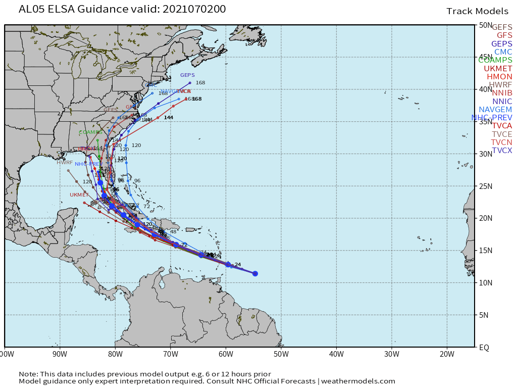
HWRF doesn’t seem to cave but it seems to be trending west with every run.
0 likes
The posts in this forum are NOT official forecasts and should not be used as such. They are just the opinion of the poster and may or may not be backed by sound meteorological data. They are NOT endorsed by any professional institution or STORM2K. For official information, please refer to products from the NHC and NWS.
Model Runs Cheat Sheet:
GFS (5:30 AM/PM, 11:30 AM/PM)
HWRF, GFDL, UKMET, NAVGEM (6:30-8:00 AM/PM, 12:30-2:00 AM/PM)
ECMWF (1:45 AM/PM)
TCVN is a weighted averaged
-
Category5Kaiju

- Category 5
- Posts: 4338
- Joined: Thu Dec 24, 2020 12:45 pm
- Location: Seattle during the summer, Phoenix during the winter
Re: ATL: ELSA - Models
More west= more time over water and less land interaction= stronger storm (of course, assuming wind shear is light and the environment is decently moist)
0 likes
Unless explicitly stated, all information in my posts is based on my own opinions and observations. Tropical storms and hurricanes can be extremely dangerous. Refer to an accredited weather research agency or meteorologist if you need to make serious decisions regarding an approaching storm.


Re: ATL: ELSA - Models
AutoPenalti wrote:HWRF doesn’t seem to cave but it seems to be trending west with every run.
Seems like an outlier. I’m not going to dis the HWRF within about 5 days. But that run ends at 126 hours south of 26 and close to 87W. Some models build back in the ridge strongly a few days after Elsa lifts out and attacks the seaboard. But most of them kept it east of 84. If the HWRF is right, and that’s questionable at best right now, that basically brings at least SE MS into possible play. Certainly points farther east than that would be as well. Last night I didn’t post it, but I was thinking Cape Coral to maybe a little east of Apalachicola was the spread - relatively narrow as far as longitudes but far away from each other.
I’m glad HWRF seems to be mostly on its own and hope that it’s not a trailblazer for the rest.
0 likes
-
toad strangler

- S2K Supporter

- Posts: 4546
- Joined: Sun Jul 28, 2013 3:09 pm
- Location: Earth
- Contact:
Re: ATL: ELSA - Models
Steve wrote:AutoPenalti wrote:HWRF doesn’t seem to cave but it seems to be trending west with every run.
Seems like an outlier. I’m not going to dis the HWRF within about 5 days. But that run ends at 126 hours south of 26 and close to 87W. Some models build back in the ridge strongly a few days after Elsa lifts out and attacks the seaboard. But most of them kept it east of 84. If the HWRF is right, and that’s questionable at best right now, that basically brings at least SE MS into possible play. Certainly points farther east than that would be as well. Last night I didn’t post it, but I was thinking Cape Coral to maybe a little east of Apalachicola was the spread - relatively narrow as far as longitudes but far away from each other.
I’m glad HWRF seems to be mostly on its own and hope that it’s not a trailblazer for the rest.
More than half of the last two cycles of GEFS members have done the same while papa OP stays E
2 likes
My Weather Station
https://www.wunderground.com/dashboard/pws/KFLPORTS603
https://www.wunderground.com/dashboard/pws/KFLPORTS603
Re: ATL: ELSA - Models
Yeah. I saw those concentrations. But I wasn’t taking them seriously yet. Unfortunately I’ll probably stay up to watch at least some of the 00z globals.
5 likes
Re: ATL: FIVE - Models
floridasun78 wrote:StPeteMike wrote:floridasun78 wrote:nhc dont see this as hurr their think it stay under 60mph or so as get to cuba
It’s not that they don’t see Elsa as a hurricane, they do acknowledge their forecast is at the lower end of forecast intensity models and are being somewhat conservative.
They’re mainly waiting for the storm to pass the islands to get a better understanding on if there will be any interaction with the Greater Antilles.
plane will tell us more on friday too
YES, yes and more yes! Currently these running of approximated data, so the intensity forecast is just that much more well unknown! The model runs after we get and feed in solid data tommorow about the true inner structure etc etc etc.
SUSPECT AREA (EAST OF WINDWARD ISLANDS)
FLIGHT ONE - TEAL 71
A. 02/1200Z
B. AFXXX 01BBA INVEST
C. 02/0715Z
D. 12.7N 58.9W
E. 02/1130Z TO 02/1500Z
F. SFC TO 10,000 FEET
0 likes

Re: ATL: ELSA - Models
Steve wrote:eastcoastFL wrote:toad strangler wrote:18z GEFS are once again weighted much further WEST even with the Op shift EAST
Gonna be a long weekend with the wind shield wipers on
Florida vs Florida. Haha.
Just like old times Steve
3 likes
Re: ATL: ELSA - Models
Let’s put this into perspective. What do we know. GFS is always right biased Euro is left biased. The 12Z Euro destroys Elsa into nothing mlore than some clouds. GFS wants to pound FL bend or maybe Tampa. What are the ensembles doing? They are more spread out than before. What does climatology tells us in July??? Hotter than hell with a robust BH over the EC. Rare that a trof will dig deep enough in freakin July to turn anything that is moving at 30mph. Remember IKE up into FL then Euro did a 900 mile correction into Brownsville then moved up the coast. Point is med range is not set in stone. The EURO will always be king. 
1 likes
-
toad strangler
- S2K Supporter
- Posts: 4546
- Joined: Sun Jul 28, 2013 3:09 pm
- Location: Earth
- Contact:
Re: ATL: ELSA - Models
11 PM NHC cone center track looks like the 18z GFS
0 likes
My Weather Station
https://www.wunderground.com/dashboard/pws/KFLPORTS603
https://www.wunderground.com/dashboard/pws/KFLPORTS603
Re: ATL: ELSA - Models
Icon for the severalith run in a row peels off the energy into the front again.
0 likes

Re: ATL: ELSA - Models
Steve wrote:Icon for the severalith run in a row peels off the energy into the front again.
Initializes at 1010 mb.. way off
5 likes
-
toad strangler
- S2K Supporter
- Posts: 4546
- Joined: Sun Jul 28, 2013 3:09 pm
- Location: Earth
- Contact:
Re: ATL: ELSA - Models
0Z GFS rolling and a touch SW and weaker than the last two runs through 42 hrs
Last edited by toad strangler on Thu Jul 01, 2021 10:51 pm, edited 2 times in total.
0 likes
My Weather Station
https://www.wunderground.com/dashboard/pws/KFLPORTS603
https://www.wunderground.com/dashboard/pws/KFLPORTS603
-
AxaltaRacing24
- Category 5
- Posts: 1774
- Age: 25
- Joined: Wed Jul 27, 2016 11:14 am
- Location: Jupiter, FL
Re: ATL: ELSA - Models
Steve wrote:Icon for the severalith run in a row peels off the energy into the front again.
Unfortunately, it seems that the 2020 issues of models poofing everything is going to continue.
1 likes
-
ElectricStorm

- Category 5
- Posts: 5148
- Age: 25
- Joined: Tue Aug 13, 2019 11:23 pm
- Location: Norman, OK
Re: ATL: ELSA - Models
0z GFS a few mb weaker than 18z but similar track so far through hour 48
0 likes
B.S Meteorology, University of Oklahoma '25
Please refer to the NHC, NWS, or SPC for official information.
Please refer to the NHC, NWS, or SPC for official information.
-
toad strangler
- S2K Supporter
- Posts: 4546
- Joined: Sun Jul 28, 2013 3:09 pm
- Location: Earth
- Contact:
Re: ATL: ELSA - Models
0z GFS eyeballing a E Jamaica hit
0 likes
My Weather Station
https://www.wunderground.com/dashboard/pws/KFLPORTS603
https://www.wunderground.com/dashboard/pws/KFLPORTS603
-
toad strangler
- S2K Supporter
- Posts: 4546
- Joined: Sun Jul 28, 2013 3:09 pm
- Location: Earth
- Contact:
Re: ATL: ELSA - Models
BOOM right over the heart of Jamaica 66 through 72 exiting 991mb heading NW and not caving to the Euro in any way shape or form
Last edited by toad strangler on Thu Jul 01, 2021 11:01 pm, edited 1 time in total.
0 likes
My Weather Station
https://www.wunderground.com/dashboard/pws/KFLPORTS603
https://www.wunderground.com/dashboard/pws/KFLPORTS603
-
ElectricStorm
- Category 5
- Posts: 5148
- Age: 25
- Joined: Tue Aug 13, 2019 11:23 pm
- Location: Norman, OK
Re: ATL: ELSA - Models
Weather Dude wrote:0z GFS a few mb weaker than 18z but similar track so far through hour 48
Now it's a little stronger and a bit further west than 18z
0 likes
B.S Meteorology, University of Oklahoma '25
Please refer to the NHC, NWS, or SPC for official information.
Please refer to the NHC, NWS, or SPC for official information.
-
toad strangler
- S2K Supporter
- Posts: 4546
- Joined: Sun Jul 28, 2013 3:09 pm
- Location: Earth
- Contact:
Re: ATL: ELSA - Models
Through 84 hrs the 0z GFS definitely S & W of the last two runs. Moving towards ensembles?
0 likes
My Weather Station
https://www.wunderground.com/dashboard/pws/KFLPORTS603
https://www.wunderground.com/dashboard/pws/KFLPORTS603
-
ElectricStorm
- Category 5
- Posts: 5148
- Age: 25
- Joined: Tue Aug 13, 2019 11:23 pm
- Location: Norman, OK
Re: ATL: ELSA - Models
979mb heading to W Cuba at hour 96
0 likes
B.S Meteorology, University of Oklahoma '25
Please refer to the NHC, NWS, or SPC for official information.
Please refer to the NHC, NWS, or SPC for official information.
Who is online
Users browsing this forum: No registered users and 20 guests