ATL: ELSA - Models

Moderator: S2k Moderators

Message
Author
User avatar
eastcoastFL
Category 5
Category 5
Posts: 3901
Age: 43
Joined: Thu Apr 12, 2007 12:29 pm
Location: Palm City, FL

Re: ATL: ELSA - Models

#581 Postby eastcoastFL » Fri Jul 02, 2021 12:46 pm

Jr0d wrote:
AutoPenalti wrote:Here comes the turn.. 954mb

HWRF going bonkers...


Unreal...hopefully it goes west of the FL. Keys....or East...just not a direct hit.

If this is true, it will be a disaster for the area. The local officials still are going with a tropical storm is our only threat. If this verifies it will be too late for evacuations late Sunday\early Monday. The holiday weekend brings in over 100,000 tourists to the Florida Keys.

I hope the NHC stops being so conservative with the intensity forecast....Monroe County has a meeting at 5pm this afternoon. If Elsa is still only forecast to be a storm over the Keys, they will take minimum precautions.


Looks like it will go slightly to your west. At least on HWRF
0 likes   
Personal Forecast Disclaimer:
The posts in this forum are NOT official forecast and should not be used as such. They are just the opinion of the poster and may or may not be backed by sound meteorological data. They are NOT endorsed by any professional institution or storm2k.org. For official information, please refer to the NHC and NWS products.

User avatar
eastcoastFL
Category 5
Category 5
Posts: 3901
Age: 43
Joined: Thu Apr 12, 2007 12:29 pm
Location: Palm City, FL

Re: ATL: ELSA - Models

#582 Postby eastcoastFL » Fri Jul 02, 2021 12:47 pm

Cuba takes a big bite but still intact

Image
0 likes   
Personal Forecast Disclaimer:
The posts in this forum are NOT official forecast and should not be used as such. They are just the opinion of the poster and may or may not be backed by sound meteorological data. They are NOT endorsed by any professional institution or storm2k.org. For official information, please refer to the NHC and NWS products.

User avatar
gatorcane
S2K Supporter
S2K Supporter
Posts: 23691
Age: 47
Joined: Sun Mar 13, 2005 3:54 pm
Location: Boca Raton, FL

Re: ATL: ELSA - Models

#583 Postby gatorcane » Fri Jul 02, 2021 12:49 pm

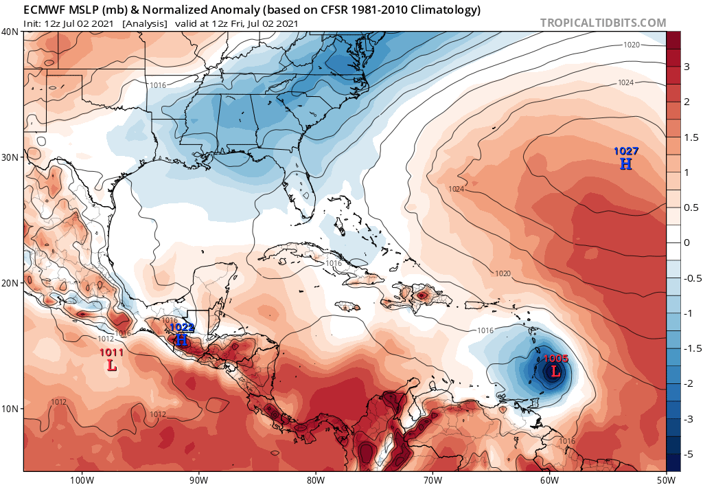
12Z Euro initialized:

Image
0 likes   

AutoPenalti
Category 5
Category 5
Posts: 4030
Age: 29
Joined: Mon Aug 17, 2015 4:16 pm
Location: Ft. Lauderdale, Florida

Re: ATL: ELSA - Models

#584 Postby AutoPenalti » Fri Jul 02, 2021 12:52 pm

Stronger ridge on the Euro.
0 likes   
The posts in this forum are NOT official forecasts and should not be used as such. They are just the opinion of the poster and may or may not be backed by sound meteorological data. They are NOT endorsed by any professional institution or STORM2K. For official information, please refer to products from the NHC and NWS.


Model Runs Cheat Sheet:
GFS (5:30 AM/PM, 11:30 AM/PM)
HWRF, GFDL, UKMET, NAVGEM (6:30-8:00 AM/PM, 12:30-2:00 AM/PM)
ECMWF (1:45 AM/PM)

TCVN
is a weighted averaged

User avatar
gatorcane
S2K Supporter
S2K Supporter
Posts: 23691
Age: 47
Joined: Sun Mar 13, 2005 3:54 pm
Location: Boca Raton, FL

Re: ATL: ELSA - Models

#585 Postby gatorcane » Fri Jul 02, 2021 12:53 pm

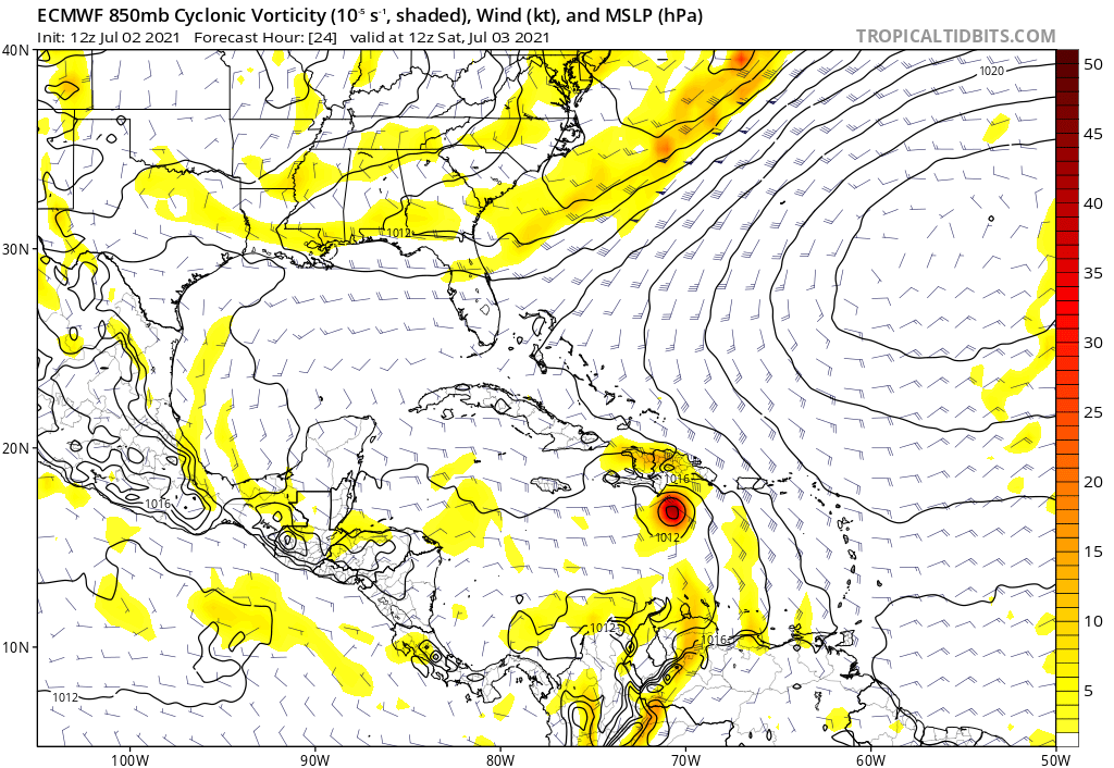
+24 hours:

Image
0 likes   

User avatar
Jr0d
S2K Supporter
S2K Supporter
Posts: 1409
Joined: Tue Aug 27, 2019 10:52 am
Location: Cayo Hueso

Re: ATL: ELSA - Models

#586 Postby Jr0d » Fri Jul 02, 2021 12:54 pm

eastcoastFL wrote:
Jr0d wrote:
AutoPenalti wrote:Here comes the turn.. 954mb

HWRF going bonkers...


Unreal...hopefully it goes west of the FL. Keys....or East...just not a direct hit.

If this is true, it will be a disaster for the area. The local officials still are going with a tropical storm is our only threat. If this verifies it will be too late for evacuations late Sunday\early Monday. The holiday weekend brings in over 100,000 tourists to the Florida Keys.

I hope the NHC stops being so conservative with the intensity forecast....Monroe County has a meeting at 5pm this afternoon. If Elsa is still only forecast to be a storm over the Keys, they will take minimum precautions.


Looks like it will go slightly to your west. At least on HWRF


Way too close for comfort.....even though it Cuba will weaken the storm, it does not take much time for a storm over the Gulfstream to intensify quickly...and an intensifying storm 8s much more intense than a weakening storm. Given the tenacity of Elsa so far, I think it is wise not to under estimate her.

Unfortunately I do not think the GFS will run again before the 5pm advisory....I am very interested in what the NHC will do. Based on the HWRF and the abundance of caution I would think they will forecast Elsa to be a hurricane when it makes her close approach to the Florida Keys ...even though it is often overly bullish.
2 likes   

AutoPenalti
Category 5
Category 5
Posts: 4030
Age: 29
Joined: Mon Aug 17, 2015 4:16 pm
Location: Ft. Lauderdale, Florida

Re: ATL: ELSA - Models

#587 Postby AutoPenalti » Fri Jul 02, 2021 12:57 pm

FWIW, last 4 runs...

Image
0 likes   
The posts in this forum are NOT official forecasts and should not be used as such. They are just the opinion of the poster and may or may not be backed by sound meteorological data. They are NOT endorsed by any professional institution or STORM2K. For official information, please refer to products from the NHC and NWS.


Model Runs Cheat Sheet:
GFS (5:30 AM/PM, 11:30 AM/PM)
HWRF, GFDL, UKMET, NAVGEM (6:30-8:00 AM/PM, 12:30-2:00 AM/PM)
ECMWF (1:45 AM/PM)

TCVN
is a weighted averaged

AutoPenalti
Category 5
Category 5
Posts: 4030
Age: 29
Joined: Mon Aug 17, 2015 4:16 pm
Location: Ft. Lauderdale, Florida

Re: ATL: ELSA - Models

#588 Postby AutoPenalti » Fri Jul 02, 2021 12:59 pm

HMON has landfall in Punta Gorda
1 likes   
The posts in this forum are NOT official forecasts and should not be used as such. They are just the opinion of the poster and may or may not be backed by sound meteorological data. They are NOT endorsed by any professional institution or STORM2K. For official information, please refer to products from the NHC and NWS.


Model Runs Cheat Sheet:
GFS (5:30 AM/PM, 11:30 AM/PM)
HWRF, GFDL, UKMET, NAVGEM (6:30-8:00 AM/PM, 12:30-2:00 AM/PM)
ECMWF (1:45 AM/PM)

TCVN
is a weighted averaged

User avatar
gatorcane
S2K Supporter
S2K Supporter
Posts: 23691
Age: 47
Joined: Sun Mar 13, 2005 3:54 pm
Location: Boca Raton, FL

Re: ATL: ELSA - Models

#589 Postby gatorcane » Fri Jul 02, 2021 1:01 pm

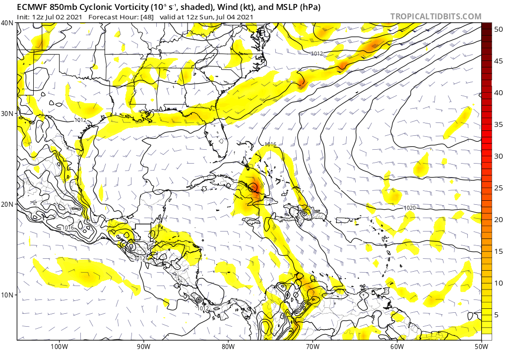
Euro 48 hours:

Image
0 likes   

User avatar
sponger
S2K Supporter
S2K Supporter
Posts: 1620
Joined: Thu Jul 22, 2004 11:26 am
Location: St Augustine

Re: ATL: ELSA - Models

#590 Postby sponger » Fri Jul 02, 2021 1:05 pm

These last few frames of the HMON will be interesting.


Center continues NW past 84W at hour 108.

https://www.tropicaltidbits.com/analysis/models/?model=hwrf&region=05L&pkg=mslp_pcpn_frzn&runtime=2021070212&fh=144
Last edited by sponger on Fri Jul 02, 2021 1:09 pm, edited 5 times in total.
0 likes   
The following post is NOT an official forecast and should not be used as such. It is just the opinion of the poster and may or may not be backed by sound meteorological data. It is NOT endorsed by any professional institution including storm2k.org For Official Information please refer to the NHC and NWS products.

User avatar
NDG
S2K Supporter
S2K Supporter
Posts: 15446
Joined: Sun Jul 09, 2006 10:14 pm
Location: Orlando, FL

Re: ATL: ELSA - Models

#591 Postby NDG » Fri Jul 02, 2021 1:05 pm

Look who's coming on board little by little :lol:

Image
8 likes   

User avatar
gatorcane
S2K Supporter
S2K Supporter
Posts: 23691
Age: 47
Joined: Sun Mar 13, 2005 3:54 pm
Location: Boca Raton, FL

Re: ATL: ELSA - Models

#592 Postby gatorcane » Fri Jul 02, 2021 1:07 pm

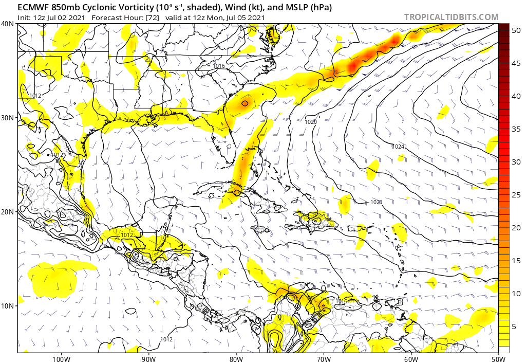
Euro 72 hours, open wave off SE Florida coast:

Image
0 likes   

AxaltaRacing24
Category 5
Category 5
Posts: 1753
Age: 25
Joined: Wed Jul 27, 2016 11:14 am
Location: Jupiter, FL

Re: ATL: ELSA - Models

#593 Postby AxaltaRacing24 » Fri Jul 02, 2021 1:10 pm

gatorcane wrote:Euro 72 hours, open wave off SE Florida coast:

https://i.postimg.cc/Hs9czmFy/ecmwf-uv850-vort-watl-4.png

This model hates Elsa.
3 likes   

User avatar
Blown Away
S2K Supporter
S2K Supporter
Posts: 10145
Joined: Wed May 26, 2004 6:17 am

Re: ATL: ELSA - Models

#594 Postby Blown Away » Fri Jul 02, 2021 1:10 pm

For SE FL Euro track is the worst, clips Haiti & E Cuba and has most time over water... Fortunately it basically dissipates it after clipping Haiti...
0 likes   
Hurricane Eye Experience: David 79, Irene 99, Frances 04, Jeanne 04, Wilma 05... EYE COMING MY WAY IN 2024…
Hurricane Brush Experience: Andrew 92, Erin 95, Floyd 99, Matthew 16, Irma 17, Ian 22, Nicole 22…

User avatar
eastcoastFL
Category 5
Category 5
Posts: 3901
Age: 43
Joined: Thu Apr 12, 2007 12:29 pm
Location: Palm City, FL

Re: ATL: ELSA - Models

#595 Postby eastcoastFL » Fri Jul 02, 2021 1:11 pm

gatorcane wrote:Euro 72 hours, open wave off SE Florida coast:

https://i.postimg.cc/Hs9czmFy/ecmwf-uv850-vort-watl-4.png


Now instead of DR busting it open its Cuba. Maybe it will get lucky and be right. I wouldn’t be mad.
0 likes   
Personal Forecast Disclaimer:
The posts in this forum are NOT official forecast and should not be used as such. They are just the opinion of the poster and may or may not be backed by sound meteorological data. They are NOT endorsed by any professional institution or storm2k.org. For official information, please refer to the NHC and NWS products.

User avatar
captainbarbossa19
Professional-Met
Professional-Met
Posts: 1092
Age: 27
Joined: Wed Aug 21, 2019 11:09 pm
Location: Beaumont, TX

Re: ATL: ELSA - Models

#596 Postby captainbarbossa19 » Fri Jul 02, 2021 1:11 pm

gatorcane wrote:Euro 72 hours, open wave off SE Florida coast:

https://i.postimg.cc/Hs9czmFy/ecmwf-uv850-vort-watl-4.png


It just keeps saying, "let it go Elsa! You are a monster!"
5 likes   

Cat5James
Category 1
Category 1
Posts: 417
Joined: Fri Sep 06, 2019 7:54 pm

Re: ATL: ELSA - Models

#597 Postby Cat5James » Fri Jul 02, 2021 1:14 pm

Disregarding what the Euro does with Elsa itself, it is showing a different ridging solution for July 5th then the GFS. The bridge does not stretch across Florida as the GFS is showing. Interesting to have such different solutions even in HP ridge 3 days out.
0 likes   

jlauderdal
S2K Supporter
S2K Supporter
Posts: 7182
Joined: Wed May 19, 2004 5:46 am
Location: NE Fort Lauderdale
Contact:

Re: ATL: ELSA - Models

#598 Postby jlauderdal » Fri Jul 02, 2021 1:21 pm


Ridge building in, euro finally getting the right idea, of course, the intensity is still a mess, may take another day or two for the model to resolve a solution that actually makes some sense
0 likes   

User avatar
Nimbus
Category 5
Category 5
Posts: 5300
Joined: Mon Jul 19, 2004 10:54 am

Re: ATL: ELSA - Models

#599 Postby Nimbus » Fri Jul 02, 2021 1:22 pm

Cat5James wrote:Disregarding what the Euro does with Elsa itself, it is showing a different ridging solution for July 5th then the GFS. The bridge does not stretch across Florida as the GFS is showing. Interesting to have such different solutions even in HP ridge 3 days out.


12Z HWRF is seeing the 12z GFS ridging evolution with a track near Apalachicola.
What does the shallow-Layer Beta and Advection Model Track Forecast show for remnants VS well developed cyclone BAMD?
Last edited by Nimbus on Fri Jul 02, 2021 1:30 pm, edited 2 times in total.
0 likes   

AutoPenalti
Category 5
Category 5
Posts: 4030
Age: 29
Joined: Mon Aug 17, 2015 4:16 pm
Location: Ft. Lauderdale, Florida

Re: ATL: ELSA - Models

#600 Postby AutoPenalti » Fri Jul 02, 2021 1:24 pm

Nimbus wrote:
Cat5James wrote:Disregarding what the Euro does with Elsa itself, it is showing a different ridging solution for July 5th then the GFS. The bridge does not stretch across Florida as the GFS is showing. Interesting to have such different solutions even in HP ridge 3 days out.


12Z HWRF is seeing the 12z GFS ridging evolution with a track near Apalachicola.
What does the low level barometric model show for remnants VS well developed cyclone BAMD?

Doesn't the HWRF use the same synoptic environment as the GFS?
0 likes   
The posts in this forum are NOT official forecasts and should not be used as such. They are just the opinion of the poster and may or may not be backed by sound meteorological data. They are NOT endorsed by any professional institution or STORM2K. For official information, please refer to products from the NHC and NWS.


Model Runs Cheat Sheet:
GFS (5:30 AM/PM, 11:30 AM/PM)
HWRF, GFDL, UKMET, NAVGEM (6:30-8:00 AM/PM, 12:30-2:00 AM/PM)
ECMWF (1:45 AM/PM)

TCVN
is a weighted averaged


Return to “2021”

Who is online

Users browsing this forum: No registered users and 2 guests