EPAC: FELICIA - Post-Tropical

Moderator: S2k Moderators

Message
Author
User avatar
cycloneye
Admin
Admin
Posts: 145277
Age: 68
Joined: Thu Oct 10, 2002 10:54 am
Location: San Juan, Puerto Rico

Re: EPAC: FELICIA - Hurricane

#301 Postby cycloneye » Fri Jul 16, 2021 7:33 pm

A. 06E (FELICIA)

B. 16/2330Z

C. 14.7N

D. 122.7W

E. TWO/GOES-W

F. T6.0/6.0

G. IR/EIR/SWIR

H. REMARKS...A WMG EYE SURROUNDED BY BLACK AND EMBEDDED IN LIGHT GREY
YIELDS A DT OF 6.0 USING THE EYE PATTERN. MET IS EQUAL TO 5.5 AND PT
IS EQUAL TO 6.0 BASED ON A DEVELOPING TREND IN THE LAST 24 HOURS. FT IS
BASED ON DT.

I. ADDL POSITIONS

NIL


...TUGGLE
0 likes   
Visit the Caribbean-Central America Weather Thread where you can find at first post web cams,radars
and observations from Caribbean basin members Click Here

User avatar
cycloneye
Admin
Admin
Posts: 145277
Age: 68
Joined: Thu Oct 10, 2002 10:54 am
Location: San Juan, Puerto Rico

Re: EPAC: FELICIA - Hurricane

#302 Postby cycloneye » Fri Jul 16, 2021 7:40 pm

Remains at 115kts.

EP, 06, 2021071700, , BEST, 0, 148N, 1228W, 115, 954, HU
0 likes   
Visit the Caribbean-Central America Weather Thread where you can find at first post web cams,radars
and observations from Caribbean basin members Click Here

User avatar
aspen
Category 5
Category 5
Posts: 8818
Joined: Sat Oct 12, 2019 7:10 pm
Location: Connecticut, USA

Re: EPAC: FELICIA - Hurricane

#303 Postby aspen » Fri Jul 16, 2021 7:48 pm

I really don’t think this is the same intensity as Hurricane Olivia. These exceptionally well-organized majors with rather warm CDOs continue to be such a challenge to get a good intensity estimate without recon. Like Douglas, I think Felicia is at least 5 kt stronger.
2 likes   
Irene '11 Sandy '12 Hermine '16 5/15/2018 Derecho Fay '20 Isaias '20 Elsa '21 Henri '21 Ida '21

I am only a meteorology enthusiast who knows a decent amount about tropical cyclones. Look to the professional mets, the NHC, or your local weather office for the best information.

User avatar
Kingarabian
S2K Supporter
S2K Supporter
Posts: 15979
Joined: Sat Aug 08, 2009 3:06 am
Location: Honolulu, Hawaii

Re: EPAC: FELICIA - Hurricane

#304 Postby Kingarabian » Fri Jul 16, 2021 8:01 pm

Its running south of the NHC track.

Looking spectacular with the sun going down:
Image
7 likes   
RIP Kobe Bryant

User avatar
Yellow Evan
Professional-Met
Professional-Met
Posts: 16143
Age: 27
Joined: Fri Jul 15, 2011 12:48 pm
Location: Henderson, Nevada/Honolulu, HI
Contact:

Re: EPAC: FELICIA - Hurricane

#305 Postby Yellow Evan » Fri Jul 16, 2021 8:38 pm

Image

Holding steady at T6.0. Very classic EPAC straight runner major.
3 likes   

User avatar
Yellow Evan
Professional-Met
Professional-Met
Posts: 16143
Age: 27
Joined: Fri Jul 15, 2011 12:48 pm
Location: Henderson, Nevada/Honolulu, HI
Contact:

Re: EPAC: FELICIA - Hurricane

#306 Postby Yellow Evan » Fri Jul 16, 2021 9:05 pm

----- Current Analysis -----
Date : 17 JUL 2021 Time : 012031 UTC
Lat : 14:41:59 N Lon : 122:54:00 W


CI# /Pressure/ Vmax
5.7 / 957.5mb/107.2kt


Final T# Adj T# Raw T#
5.7 5.6 5.6

Estimated radius of max. wind based on IR : 16 km

Center Temp : +16.7C Cloud Region Temp : -58.0C

Scene Type : EYE
0 likes   

User avatar
cycloneye
Admin
Admin
Posts: 145277
Age: 68
Joined: Thu Oct 10, 2002 10:54 am
Location: San Juan, Puerto Rico

Re: EPAC: FELICIA - Hurricane

#307 Postby cycloneye » Fri Jul 16, 2021 9:34 pm

Hurricane Felicia Discussion Number 12
NWS National Hurricane Center Miami FL EP062021
500 PM HST Fri Jul 16 2021

Felicia continues to exhibit characteristics of a classic major
hurricane. The eye remains clear while the CDO is symmetrical with
uniform cold cloud tops surrounding the center. The latest Dvorak
T-numbers from TAFB and SAB support keeping the initial intensity at
115 kt for this advisory. Felicia is a small hurricane, and recent
ASCAT overpasses showed that the tropical-storm-force winds extend
only about 40-50 n mi from the center.

Since earlier this afternoon, the hurricane has been moving south
of due west, or 260/08 kt. A strong ridge to the north of the
Felicia is expected to maintain it on a generally westward motion
for the next several days. Late in the forecast period, the model
guidance has trended toward a slightly faster forward motion. The
latest NHC forecast track is close to the previous one through 72 h,
but now lies in between the previous forecast and the track
consensus guidance thereafter.

Felicia is expected to move over gradually decreasing SSTs over the
next few days which should induce a slow weakening trend beginning
later tonight or on Saturday. Although the hurricane is surrounded
by dry air, it is maintaining an annular structure while it is
expected to remain in an environment of low vertical wind shear for
at least a few more days. These factors may prevent this dry air
from entraining into the cyclone's circulation for some time.
Because of this, the latest NHC intensity prediction remains on the
high end of the guidance for the entire forecast period, with the
main factor contributing to weakening being the cooler SSTs.

FORECAST POSITIONS AND MAX WINDS

INIT 17/0300Z 14.8N 123.2W 115 KT 130 MPH
12H 17/1200Z 14.6N 124.5W 110 KT 125 MPH
24H 18/0000Z 14.7N 126.1W 100 KT 115 MPH
36H 18/1200Z 15.1N 128.0W 95 KT 110 MPH
48H 19/0000Z 15.4N 129.9W 85 KT 100 MPH
60H 19/1200Z 15.5N 131.9W 80 KT 90 MPH
72H 20/0000Z 15.5N 134.0W 70 KT 80 MPH
96H 21/0000Z 14.7N 138.2W 60 KT 70 MPH
120H 22/0000Z 13.9N 143.2W 50 KT 60 MPH

$$
Forecaster Latto
0 likes   
Visit the Caribbean-Central America Weather Thread where you can find at first post web cams,radars
and observations from Caribbean basin members Click Here

Sciencerocks
Category 5
Category 5
Posts: 9154
Age: 39
Joined: Thu Jul 06, 2017 1:51 am

Re: EPAC: FELICIA - Hurricane

#308 Postby Sciencerocks » Sat Jul 17, 2021 12:23 am

Image
9 likes   

User avatar
Stormybajan
Category 1
Category 1
Posts: 448
Joined: Thu May 20, 2021 3:21 pm
Location: Windward Islands

Re: EPAC: FELICIA - Hurricane

#309 Postby Stormybajan » Sat Jul 17, 2021 12:30 am


Amazing at the end there it changes itself to to a perfect Donut ring of a Hurricane 8-)
4 likes   
Sad West Indies and Manchester United fan ⚽️

User avatar
Yellow Evan
Professional-Met
Professional-Met
Posts: 16143
Age: 27
Joined: Fri Jul 15, 2011 12:48 pm
Location: Henderson, Nevada/Honolulu, HI
Contact:

Re: EPAC: FELICIA - Hurricane

#310 Postby Yellow Evan » Sat Jul 17, 2021 1:26 am

Image

So tiny.
2 likes   

User avatar
Yellow Evan
Professional-Met
Professional-Met
Posts: 16143
Age: 27
Joined: Fri Jul 15, 2011 12:48 pm
Location: Henderson, Nevada/Honolulu, HI
Contact:

Re: EPAC: FELICIA - Hurricane

#311 Postby Yellow Evan » Sat Jul 17, 2021 1:30 am

TXPZ25 KNES 170552
TCSENP

A. 06E (FELICIA)

B. 17/0530Z

C. 14.6N

D. 123.4W

E. TWO/GOES-W

F. T5.5/5.5

G. IR/EIR/SWIR

H. REMARKS... A WMG EYE SURROUNDED BY LG AND EMBEDDED IN LG YIELDS A
DT OF 5.5 BASED ON EYE PATTERN. MET AND PT ARE BOTH EQUAL TO 6.0 BASED
ON A SLIGHT DEVELOPMENT TREND IN THE LAST 24 HOURS. FT IS BASED ON DT.

I. ADDL POSITIONS

NIL


...TUGGLE


Lol B ring broke right in time again.
0 likes   

User avatar
Yellow Evan
Professional-Met
Professional-Met
Posts: 16143
Age: 27
Joined: Fri Jul 15, 2011 12:48 pm
Location: Henderson, Nevada/Honolulu, HI
Contact:

Re: EPAC: FELICIA - Hurricane

#312 Postby Yellow Evan » Sat Jul 17, 2021 1:33 am

Image

T6.0. B ring back.
0 likes   

User avatar
Yellow Evan
Professional-Met
Professional-Met
Posts: 16143
Age: 27
Joined: Fri Jul 15, 2011 12:48 pm
Location: Henderson, Nevada/Honolulu, HI
Contact:

Re: EPAC: FELICIA - Hurricane

#313 Postby Yellow Evan » Sat Jul 17, 2021 2:15 am

* GFS version *
* EAST PACIFIC 2021 SHIPS INTENSITY FORECAST *
* IR SAT DATA AVAILABLE, OHC AVAILABLE *
* FELICIA EP062021 07/17/21 06 UTC *

TIME (HR) 0 6 12 18 24 36 48 60 72 84 96 108 120 132 144 156 168
V (KT) NO LAND 115 111 105 100 95 87 77 71 62 56 49 44 41 38 38 38 36
V (KT) LAND 115 111 105 100 95 87 77 71 62 56 49 44 41 38 38 38 36
V (KT) LGEM 115 109 102 94 89 80 74 69 62 55 50 45 40 35 32 29 24
Storm Type TROP TROP TROP TROP TROP TROP TROP TROP TROP TROP TROP TROP TROP TROP TROP TROP TROP

SHEAR (KT) 5 5 4 7 8 6 5 4 3 2 2 14 21 20 15 17 22
SHEAR ADJ (KT) -4 -4 0 -1 -2 -3 2 4 6 4 4 1 -3 1 8 10 7
SHEAR DIR 26 359 356 34 50 69 141 351 16 21 298 326 326 328 331 298 297
SST (C) 27.5 27.1 26.8 26.5 26.6 26.8 26.6 26.8 25.9 25.4 25.8 26.0 26.2 26.3 26.7 26.7 26.2
POT. INT. (KT) 138 134 131 128 129 131 130 132 122 117 122 125 126 127 130 130 125
200 MB T (C) -52.1 -52.4 -52.3 -52.2 -52.4 -52.2 -51.8 -52.0 -52.2 -52.7 -52.5 -53.0 -52.8 -52.9 -53.0 -53.1 -53.1
200 MB VXT (C) 0.1 0.3 0.3 0.4 0.5 0.5 0.4 0.4 0.5 0.5 0.2 0.0 0.1 0.1 0.0 -0.2 -0.1
TH_E DEV (C) 5 5 5 5 5 4 4 3 4 3 4 4 5 5 5 5 6
700-500 MB RH 48 47 47 47 47 49 50 50 48 46 45 43 41 42 42 42 39
MODEL VTX (KT) 19 19 18 18 18 17 15 16 14 13 11 10 9 8 7 6 4
850 MB ENV VOR 11 5 5 0 2 -10 -16 -11 -7 -3 0 6 19 23 19 9 -6
200 MB DIV -29 -28 -21 -18 -4 -22 4 -40 -27 -12 -34 -25 -13 -15 -38 -52 -43
700-850 TADV 0 -1 -4 -5 -4 -1 0 2 3 2 0 0 -1 -3 -3 0 0
LAND (KM) 1630 1691 1754 1815 1880 1999 2120 2298 2171 1967 1766 1537 1284 1106 983 869 763
LAT (DEG N) 14.6 14.6 14.5 14.7 14.8 15.2 15.4 15.4 15.3 14.9 14.3 13.9 13.8 xx.x xx.x xx.x xx.x
LONG(DEG W) 123.5 124.3 125.0 125.9 126.8 128.8 130.6 132.8 134.8 136.9 139.1 141.6 144.3 xxx.x xxx.x xxx.x xxx.x
STM SPEED (KT) 8 7 8 9 9 9 10 10 10 10 11 13 12 10 8 8 8
HEAT CONTENT 9 4 2 1 1 5 3 3 0 0 0 0 3 1 3 4 1

FORECAST TRACK FROM OFCI INITIAL HEADING/SPEED (DEG/KT):255/ 8 CX,CY: -7/ -1
T-12 MAX WIND: 115 PRESSURE OF STEERING LEVEL (MB): 532 (MEAN=587)
GOES IR BRIGHTNESS TEMP. STD DEV. 50-200 KM RAD: 11.8 (MEAN=14.5)
% GOES IR PIXELS WITH T < -20 C 50-200 KM RAD: 50.0 (MEAN=65.0)
PRELIM RI PROB (DV .GE. 35 KT IN 36 HR): 0.0

INDIVIDUAL CONTRIBUTIONS TO INTENSITY CHANGE
6 12 18 24 36 48 60 72 84 96 108 120 132 144 156 168
------------------------------------------------------------------------------
SAMPLE MEAN CHANGE 0. 0. 1. 1. 1. 2. 1. 1. 0. -0. -1. -2. -2. -3. -4. -4.
SST POTENTIAL -2. -4. -7. -10. -17. -26. -34. -42. -49. -54. -58. -59. -61. -62. -65. -68.
VERTICAL SHEAR MAG -0. -1. -1. -2. -1. 1. 4. 7. 10. 12. 12. 10. 9. 8. 10. 10.
VERTICAL SHEAR ADJ 0. 1. 1. 1. 2. 2. 1. 0. -0. -0. -0. -0. -0. -0. -0. -1.
VERTICAL SHEAR DIR 0. 0. 1. 1. 3. 3. 3. 4. 4. 3. 2. 1. 0. -0. -1. -1.
PERSISTENCE -0. -0. -0. -1. -1. -1. -0. -0. -0. -0. -0. -0. -0. -0. -0. -0.
200/250 MB TEMP. -0. -0. -0. -0. -0. -0. 0. 1. 1. 1. 1. 0. -0. -0. -1. -1.
THETA_E EXCESS -0. -0. -0. -1. -1. -2. -3. -4. -5. -5. -5. -5. -6. -6. -6. -7.
700-500 MB RH -0. -0. -0. -1. -1. -1. -1. -1. -1. -2. -2. -2. -2. -3. -4. -5.
MODEL VTX TENDENCY 0. -1. -0. -1. -1. -4. -4. -7. -8. -12. -12. -12. -12. -12. -11. -12.
850 MB ENV VORTICITY -0. -0. -0. -0. -0. 0. 0. 1. 1. 1. 1. 1. 1. 1. 1. 1.
200 MB DIVERGENCE -0. -1. -1. -1. -1. -2. -4. -5. -6. -6. -6. -5. -3. -1. 1. 2.
850-700 T ADVEC -0. 0. 0. 0. 0. -0. -0. 0. 0. 0. 0. 0. 0. 0. 0. 0.
ZONAL STORM MOTION 0. 0. 0. 0. 0. 0. -0. -0. -0. -0. -0. -0. -0. -0. -0. 0.
STEERING LEVEL PRES -0. -0. -0. -0. -1. -1. -1. -1. -1. -1. -1. -1. -1. -1. -1. -0.
DAYS FROM CLIM. PEAK -0. -0. -0. -0. -0. -0. -0. -1. -1. -1. -1. -1. -2. -2. -2. -3.
GOES PREDICTORS -2. -3. -4. -4. -4. -3. -3. -4. -4. -4. -4. -5. -4. -3. -2. -0.
OCEAN HEAT CONTENT -0. -0. -0. -0. -0. -1. -1. -1. -0. -0. 0. 1. 2. 3. 4. 6.
RI POTENTIAL -0. -1. -2. -3. -4. -5. -3. -1. 1. 2. 4. 4. 5. 5. 4. 4.
------------------------------------------------------------------------------
TOTAL CHANGE -4. -10. -15. -20. -28. -38. -44. -53. -59. -66. -71. -74. -77. -77. -77. -79.

CURRENT MAX WIND (KT): 115. LAT, LON: 14.6 123.5

** 2021 E. Pacific RI INDEX EP062021 FELICIA 07/17/21 06 UTC **
(SHIPS-RII PREDICTOR TABLE for 30 KT OR MORE MAXIMUM WIND INCREASE IN NEXT 24-h)

Predictor Value RI Predictor Range Scaled Value(0-1) % Contribution
POT = MPI-VMAX (KT) : 17.1 40.5 to 149.3 0.00 0.0
12 HR PERSISTENCE (KT) : 0.0 -22.0 to 44.0 0.33 999.0
D200 (10**7s-1) : -20.0 -33.0 to 159.5 0.07 999.0
850-200 MB SHEAR (KT) : 6.0 19.6 to 1.3 0.74 999.0
MAXIMUM WIND (KT) : 115.0 22.5 to 132.0 0.23 999.0
STD DEV OF IR BR TEMP : 11.8 37.8 to 2.1 0.73 999.0
BL DRY-AIR FLUX (W/M2) : 851.2 800.8 to -82.5 0.00 0.0
HEAT CONTENT (KJ/CM2) : 3.4 2.7 to 106.7 0.01 999.0
%area of TPW <45 mm upshear : 0.0 56.6 to 0.0 1.00 999.0
2nd PC OF IR BR TEMP : -0.4 2.2 to -2.3 0.58 999.0

SHIPS Prob RI for 20kt/ 12hr RI threshold= 0% is 0.0 times climatological mean ( 6.3%)
SHIPS Prob RI for 25kt/ 24hr RI threshold= 0% is 0.0 times climatological mean (12.5%)
SHIPS Prob RI for 30kt/ 24hr RI threshold= 0% is 0.0 times climatological mean ( 8.6%)
SHIPS Prob RI for 35kt/ 24hr RI threshold= 0% is 0.0 times climatological mean ( 6.2%)
SHIPS Prob RI for 40kt/ 24hr RI threshold= 0% is 0.0 times climatological mean ( 4.2%)
SHIPS Prob RI for 45kt/ 36hr RI threshold= 0% is 0.0 times climatological mean ( 6.7%)
SHIPS Prob RI for 55kt/ 48hr RI threshold= 0% is 0.0 times climatological mean ( 5.9%)
SHIPS Prob RI for 65kt/ 72hr RI threshold= 0% is 0.0 times climatological mean ( 4.7%)

Matrix of RI probabilities
------------------------------------------------------------------------------
RI (kt / h) | 20/12 | 25/24 | 30/24 | 35/24 | 40/24 | 45/36 | 55/48 |65/72
------------------------------------------------------------------------------
SHIPS-RII: 0.0% 0.0% 0.0% 0.0% 0.0% 0.0% 0.0% 0.0%
Logistic: 0.7% 0.7% 0.8% 0.5% 0.8% 0.1% 0.0% 0.0%
Bayesian: 0.0% 0.0% 0.0% 0.0% 0.0% 0.0% 0.0% 0.0%
Consensus: 0.2% 0.2% 0.3% 0.2% 0.3% 0.0% 0.0% 0.0%
DTOPS: 3.0% 0.0% 0.0% 0.0% 0.0% 0.0% 0.0% 0.0%

## ANNULAR HURRICANE INDEX (AHI) EP062021 FELICIA 07/17/21 06 UTC ##
## STORM NOT ANNULAR, SCREENING STEP FAILED, NPASS=6 NFAIL=1 ##
## AHI= 0 (AHI OF 100 IS BEST FIT TO ANN. STRUC., 1 IS MARGINAL, 0 IS NOT ANNULAR) ##
0 likes   

User avatar
Kingarabian
S2K Supporter
S2K Supporter
Posts: 15979
Joined: Sat Aug 08, 2009 3:06 am
Location: Honolulu, Hawaii

Re: EPAC: FELICIA - Hurricane

#314 Postby Kingarabian » Sat Jul 17, 2021 2:34 am

Continues to be S/SE of the track:
Image

White ring returning:
Image
Last edited by Kingarabian on Sat Jul 17, 2021 2:48 am, edited 1 time in total.
0 likes   
RIP Kobe Bryant

User avatar
Kingarabian
S2K Supporter
S2K Supporter
Posts: 15979
Joined: Sat Aug 08, 2009 3:06 am
Location: Honolulu, Hawaii

Re: EPAC: FELICIA - Hurricane

#315 Postby Kingarabian » Sat Jul 17, 2021 2:48 am

Its microwave presentation hasn't missed a beat and convection is cooling and expanding again:
Image

Image
5 likes   
RIP Kobe Bryant

User avatar
Yellow Evan
Professional-Met
Professional-Met
Posts: 16143
Age: 27
Joined: Fri Jul 15, 2011 12:48 pm
Location: Henderson, Nevada/Honolulu, HI
Contact:

Re: EPAC: FELICIA - Hurricane

#316 Postby Yellow Evan » Sat Jul 17, 2021 3:22 am

Image

W ring almost complete. This hurricane just starts cooling cloud tops everytime it appears it’s about to weaken.
2 likes   

User avatar
Kingarabian
S2K Supporter
S2K Supporter
Posts: 15979
Joined: Sat Aug 08, 2009 3:06 am
Location: Honolulu, Hawaii

Re: EPAC: FELICIA - Hurricane

#317 Postby Kingarabian » Sat Jul 17, 2021 3:49 am

Yellow Evan wrote:https://cdn.discordapp.com/attachments/733552978572869632/865869730904932352/8de22b83-9e02-4f50-a436-da24b6fd2677.png

W ring almost complete. This hurricane just starts cooling cloud tops everytime it appears it’s about to weaken.

Do you have an idea why the subjective/raw ADT numbers have been running lower than SAB and TAFB? Is ADT having trouble resolving the CDO thickness because it's a small system?
0 likes   
RIP Kobe Bryant

User avatar
Kingarabian
S2K Supporter
S2K Supporter
Posts: 15979
Joined: Sat Aug 08, 2009 3:06 am
Location: Honolulu, Hawaii

Re: EPAC: FELICIA - Hurricane

#318 Postby Kingarabian » Sat Jul 17, 2021 3:52 am

Don't really see this presentation on AVN quite often. Could make the case its 125-130kts.
Image
0 likes   
RIP Kobe Bryant

User avatar
cycloneye
Admin
Admin
Posts: 145277
Age: 68
Joined: Thu Oct 10, 2002 10:54 am
Location: San Juan, Puerto Rico

Re: EPAC: FELICIA - Hurricane

#319 Postby cycloneye » Sat Jul 17, 2021 4:00 am

Hurricane Felicia Discussion Number 13
NWS National Hurricane Center Miami FL EP062021
1100 PM HST Fri Jul 16 2021

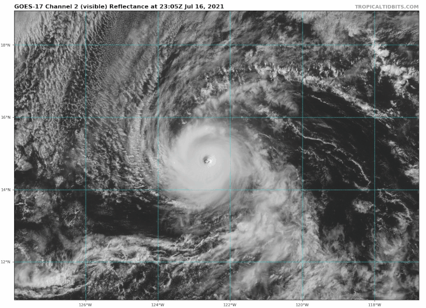
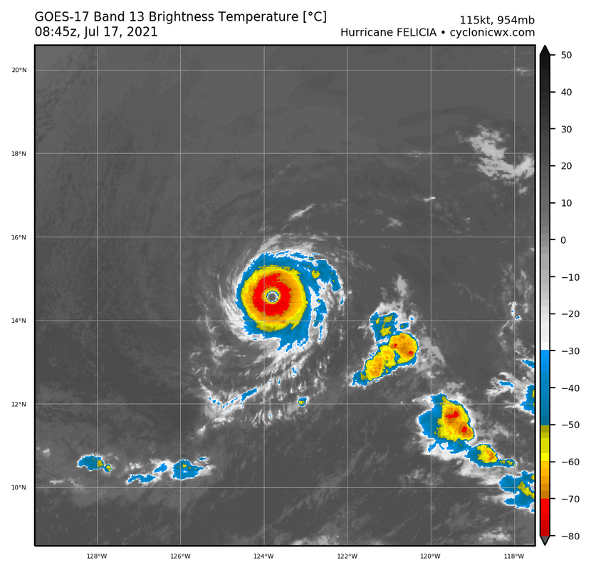
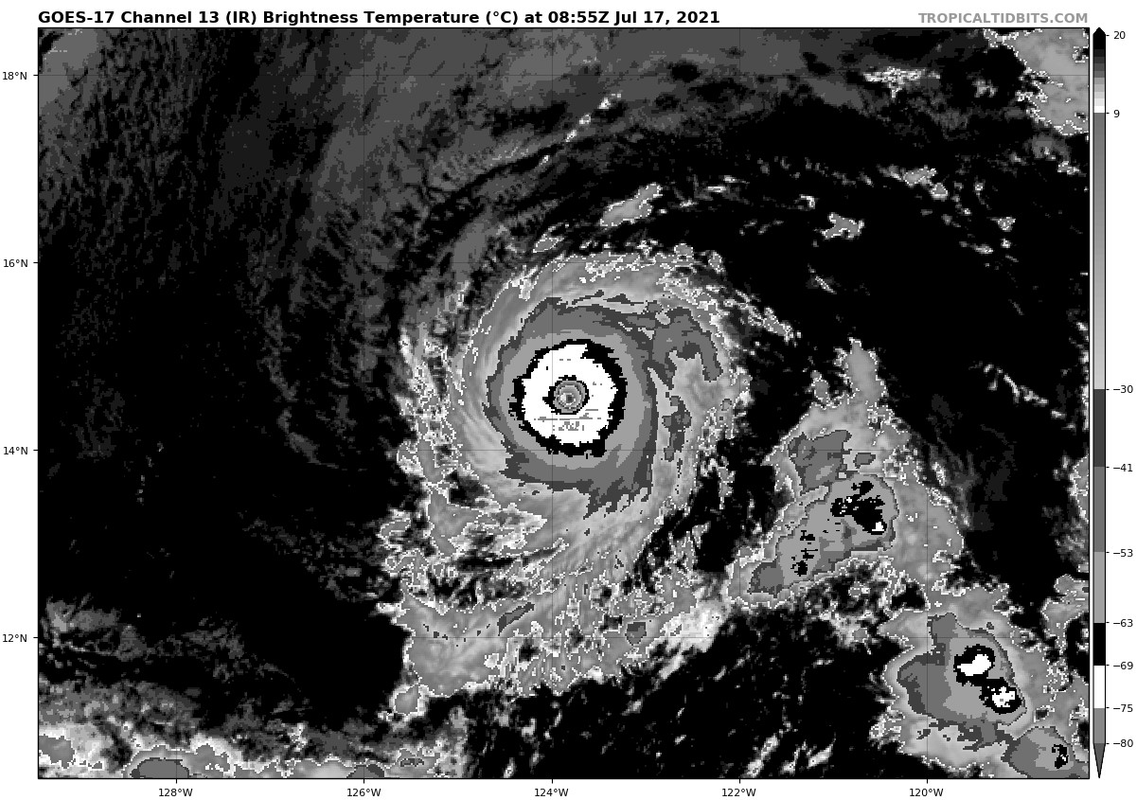
Felicia remains an impressively compact major hurricane on satellite
imagery tonight. The storm possesses a circular, clear, and warm
(10-15 C) eye surrounded by an equally symmetrical central dense
overcast (CDO) with cloud top temperatures colder than -70 C. In
addition, a 0535 UTC GMI microwave pass showed a singular closed
eyewall, with only limited outer banding outside of the inner core.
The 0600 UTC subjective Dvorak satellite estimates from TAFB and SAB
were T6.0/115 kt and T5.5/102 kt respectively, while the UW-CIMSS
ADT objective estimate was holding steady at T5.7/107 kt. Since that
time, cloud top temperatures surrounding the eye have cooled a bit
more during the diurnal max, so the initial intensity is held at 115
kt, in agreement with the higher TAFB estimate.

The hurricane has maintained more of a west-southwest motion over
the past 6-12 hours at 255/8 kt. This motion is expected to
gradually bend back westward or west-northwestward over the weekend
into early next week as a narrow mid-level ridge axis shifts back to
the north-northeast of Felicia. In the latter part of the forecast
period, a stronger deep-layer ridge north of Hawaii is expected to
become the primary steering feature, leading to a Felicia turning
back west-southwestward with gradual acceleration. The track
guidance has shifted a tad further north early on, and has continued
to speed up the forward motion near the end of the forecast period.
The latest NHC track forecast has been adjusted a little more
poleward in the first 60 hours, closer to the HCCA and TVCE
consensus aids, and is faster after 72 hours. The forecast track
still lies roughly between the previous forecast and the
aforementioned track consensus aids.

Felicia currently has the structural characteristics of an annular
hurricane, featuring a warm eye and cold circular CDO with little
additional banding beyond the eyewall. Even though sea-surface
temperatures (SSTs) slowly decrease over the next 36 hours as
Felicia remains embedded in a dry mid-level relative humidity
environment, the modest easterly vertical wind shear (around 5-kt)
forecast over the cyclone will likely prevent dry-air entrainment
that could disrupt the stable eyewall structure. Thus, the intensity
forecast for the first 36-48 hours remains above the majority of the
guidance and it would not be surprising to see Felicia maintain its
category 4 intensity longer than forecasted in the short-term. After
60 hours, the ECMWF-SHIPS guidance shows a sharp increase in
northwesterly vertical winds shear as the hurricane tracks along the
26 C SST isotherm. These more unfavorable environmental conditions
will likely lead to significant disruption of Felicia's tiny inner
core. The weakening rate has been increased a bit more in the latter
portion of the latest NHC intensity forecast, falling near the mean
of the intensity guidance and HCCA consensus aid by the end of the
forecast period.


FORECAST POSITIONS AND MAX WINDS

INIT 17/0900Z 14.5N 123.9W 115 KT 130 MPH
12H 17/1800Z 14.6N 125.0W 110 KT 125 MPH
24H 18/0600Z 14.9N 126.8W 105 KT 120 MPH
36H 18/1800Z 15.3N 128.7W 100 KT 115 MPH
48H 19/0600Z 15.7N 130.6W 90 KT 105 MPH
60H 19/1800Z 15.8N 132.6W 80 KT 90 MPH
72H 20/0600Z 15.6N 134.9W 65 KT 75 MPH
96H 21/0600Z 14.7N 140.0W 50 KT 60 MPH
120H 22/0600Z 13.8N 145.1W 40 KT 45 MPH

$$
Forecaster Papin/Beven
0 likes   
Visit the Caribbean-Central America Weather Thread where you can find at first post web cams,radars
and observations from Caribbean basin members Click Here

User avatar
Kingarabian
S2K Supporter
S2K Supporter
Posts: 15979
Joined: Sat Aug 08, 2009 3:06 am
Location: Honolulu, Hawaii

Re: EPAC: FELICIA - Hurricane

#320 Postby Kingarabian » Sat Jul 17, 2021 4:14 am

6.5?
Image
1 likes   
RIP Kobe Bryant


Return to “2021”

Who is online

Users browsing this forum: No registered users and 2 guests