EPAC: FELICIA - Post-Tropical
Moderator: S2k Moderators
-
Meteophile
- Tropical Depression

- Posts: 50
- Joined: Tue May 12, 2020 3:38 pm
Re: EPAC: FELICIA - Hurricane
First time i follow this type of storms. Small very well organized core and... that's all. ADT likely won't go above 5.5 with this size as the calculated CDO temps are made with a bigger circle than the real CDO of the storm (as far as i know).
0 likes
-
cycloneye

- Admin

- Posts: 149514
- Age: 69
- Joined: Thu Oct 10, 2002 10:54 am
- Location: San Juan, Puerto Rico
Re: EPAC: FELICIA - Hurricane
2 likes
Visit the Caribbean-Central America Weather Thread where you can find at first post web cams,radars
and observations from Caribbean basin members Click Here
and observations from Caribbean basin members Click Here
-
Kingarabian

- S2K Supporter

- Posts: 16367
- Joined: Sat Aug 08, 2009 3:06 am
- Location: Honolulu, Hawaii
Re: EPAC: FELICIA - Hurricane
cycloneye wrote:[url]https://twitter.com/KeviShader/status/1416322321615364102[url]
Yeah there's no way ADT is going to go above 6.0 with its size unless we get some insane CDG which is not gonna happen.
0 likes
RIP Kobe Bryant
-
Kingarabian
- S2K Supporter
- Posts: 16367
- Joined: Sat Aug 08, 2009 3:06 am
- Location: Honolulu, Hawaii
Re: EPAC: FELICIA - Hurricane
It has entered Hector 2018 territory IMO. It's just the size difference that's making it hard to get a higher estimate that it deserves.
Felicia TAFB 6.0/SAB 5.5/ADT 5.6:
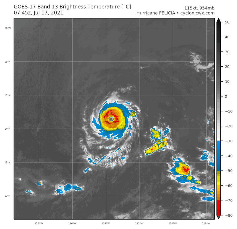
Hector 2015: SAB 6.5/ADT 6.9/Recon 135kts:
Felicia TAFB 6.0/SAB 5.5/ADT 5.6:
Hector 2015: SAB 6.5/ADT 6.9/Recon 135kts:
3 likes
RIP Kobe Bryant

Re: EPAC: FELICIA - Hurricane
Wow a perfect donut storm, can't remember the last time I saw a hurricane that looked like this. Like others have said I wished we had recon in there, because I'd be willing to bet this is stronger than 115 kts right now. But of course understandable that with the available tools they have and the current ADT values NHC is going with 115 kts for now.

7 likes
-
Kingarabian
- S2K Supporter
- Posts: 16367
- Joined: Sat Aug 08, 2009 3:06 am
- Location: Honolulu, Hawaii
Re: EPAC: FELICIA - Hurricane
More Felicia Hector similarities.
https://twitter.com/KeviShader/status/1416285722642984964
https://twitter.com/pppapin/status/1026596018136051712
https://twitter.com/KeviShader/status/1416285722642984964
https://twitter.com/pppapin/status/1026596018136051712
1 likes
RIP Kobe Bryant
-
Shell Mound
- Category 5

- Posts: 2432
- Age: 33
- Joined: Thu Sep 07, 2017 3:39 pm
- Location: St. Petersburg, FL → Scandinavia
Re: EPAC: FELICIA - Hurricane
Given the warmth of the large eye and the convective trends, I think this is one of the most impressive “annular” hurricanes that I have observed in either the Pacific or the Atlantic. The CDO is colder than those of most other “annular” systems, yet the eye is quite clear and well defined, implying a very warm, dry core. As for the current intensity, I definitely would put this on a par with Hector’s 130–135 kt, and it could be even a bit stronger. Hector, as an aside, almost certainly reached Cat-5 status for a brief duration, and last year’s Douglas, a similarly small system to Felicia, probably was at least 15 kt stronger than its “official” peak of 115 kt. Given the likelihood of low vertical wind shear through the forecast-period, Felicia is likely to be an extremely prolific ACE-producer.
https://twitter.com/pppapin/status/1416109538512625667
https://twitter.com/pppapin/status/1416115733441007625
https://twitter.com/CyanideCN_/status/1416336266417770496
https://twitter.com/KeviShader/status/1416336321644273664
https://twitter.com/stefano_gordon/status/1416323849969410051
https://twitter.com/pppapin/status/1416109538512625667
https://twitter.com/pppapin/status/1416115733441007625
https://twitter.com/CyanideCN_/status/1416336266417770496
https://twitter.com/KeviShader/status/1416336321644273664
https://twitter.com/stefano_gordon/status/1416323849969410051
1 likes
CVW / MiamiensisWx / Shell Mound
The posts in this forum are NOT official forecasts and should not be used as such. They are just the opinion of the poster and may or may not be backed by sound meteorological data. They are NOT endorsed by any professional institution or STORM2K. For official information, please refer to products from the NHC and NWS.
-
Kingarabian
- S2K Supporter
- Posts: 16367
- Joined: Sat Aug 08, 2009 3:06 am
- Location: Honolulu, Hawaii
Re: EPAC: FELICIA - Hurricane
Shell Mound wrote:Given the warmth of the large eye and the convective trends, I think this is one of the most impressive “annular” hurricanes that I have observed in either the Pacific or the Atlantic. The CDO is colder than those of most other “annular” systems, yet the eye is quite clear and well defined, implying a very warm, dry core. As for the current intensity, I definitely would put this on a par with Hector’s 130–135 kt, and it could be even a bit stronger. Hector, as an aside, almost certainly reached Cat-5 status for a brief duration, and last year’s Douglas, a similarly small system to Felicia, probably was at least 15 kt stronger than its “official” peak of 115 kt. Given the likelihood of low vertical wind shear through the forecast-period, Felicia is likely to be an extremely prolific ACE-producer.
https://twitter.com/pppapin/status/1416109538512625667
https://twitter.com/pppapin/status/1416115733441007625
https://twitter.com/CyanideCN_/status/1416336266417770496
https://twitter.com/KeviShader/status/1416336321644273664
https://twitter.com/stefano_gordon/status/1416323849969410051
Yeah it's certainly threading the needle. It still looks like it's moving south of west. The longer it keeps it up the better for its chances of a higher peak.
0 likes
RIP Kobe Bryant
-
InfernoFlameCat

- Category 5
- Posts: 2127
- Age: 22
- Joined: Mon Dec 14, 2020 10:52 am
- Location: Buford, GA
Re: EPAC: FELICIA - Hurricane
Felicia is looking like a beast
0 likes
I am by no means a professional. DO NOT look at my forecasts for official information or make decisions based on what I post.
Goal: to become a registered expert over tropical and subtropical cyclones.
Goal: to become a registered expert over tropical and subtropical cyclones.

Re: EPAC: FELICIA - Hurricane
This kind of looks like a mini version of Irma during its initial RI into a Cat 5.
With a storm like this, the NHC needs to forget about normal SAB Dvorak fixing rules and judge the storm for what it is: an annular Cat 4 with a warm eye and a perfect W ring, suggesting an intensity of 120-130 kt. Convection is also deepening, indicating that the storm continues to get stronger.
With a storm like this, the NHC needs to forget about normal SAB Dvorak fixing rules and judge the storm for what it is: an annular Cat 4 with a warm eye and a perfect W ring, suggesting an intensity of 120-130 kt. Convection is also deepening, indicating that the storm continues to get stronger.
1 likes
Irene '11 Sandy '12 Hermine '16 5/15/2018 Derecho Fay '20 Isaias '20 Elsa '21 Henri '21 Ida '21
I am only a meteorology enthusiast who knows a decent amount about tropical cyclones. Look to the professional mets, the NHC, or your local weather office for the best information.
I am only a meteorology enthusiast who knows a decent amount about tropical cyclones. Look to the professional mets, the NHC, or your local weather office for the best information.
Re: EPAC: FELICIA - Hurricane
Throw out ADT. Somehow it is only at T#5.3 despite a full W ring. We’ll just need to hope for a good SAB fix, but that thing ring due to Felicia’s small size will probably prevent that.
0 likes
Irene '11 Sandy '12 Hermine '16 5/15/2018 Derecho Fay '20 Isaias '20 Elsa '21 Henri '21 Ida '21
I am only a meteorology enthusiast who knows a decent amount about tropical cyclones. Look to the professional mets, the NHC, or your local weather office for the best information.
I am only a meteorology enthusiast who knows a decent amount about tropical cyclones. Look to the professional mets, the NHC, or your local weather office for the best information.

Re: EPAC: FELICIA - Hurricane
Kingarabian wrote:It has entered Hector 2018 territory IMO. It's just the size difference that's making it hard to get a higher estimate that it deserves.
Felicia TAFB 6.0/SAB 5.5/ADT 5.6:
https://i.postimg.cc/GmTcJJsS/goes17-ir-06-E-1.gif
Hector 2015: SAB 6.5/ADT 6.9/Recon 135kts:
https://i.postimg.cc/PfFs3vhG/cW7DJWt.gif
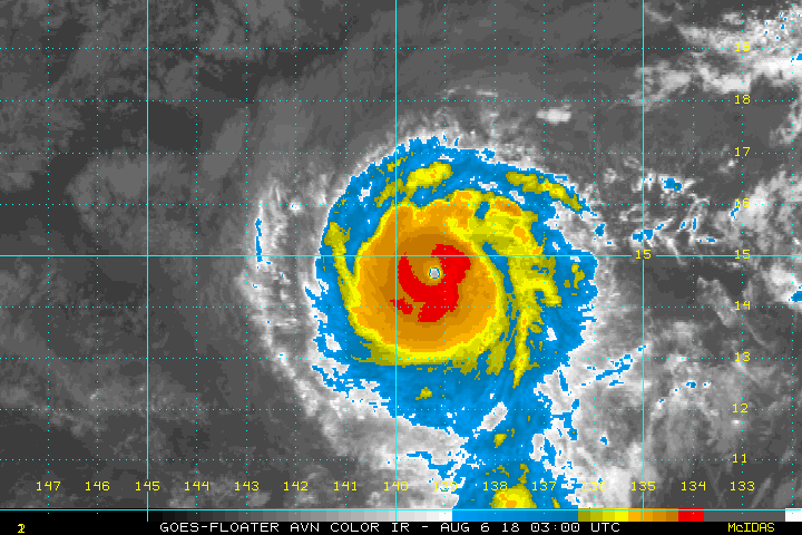
Isabel is the first storm that came to mind with Felicia's annular appearance. (Images are of Isabel, could not find a linkable IR shot of Isabel)
I do think 130mph is a very very conservative estimate.
While it is unfortunate that we will.not get any recon or other data, at least Felicia only a threat to shipping interests(long ranger dissipates Felicia well South and east of Hawaii), I would be freaking out if a storm that looks like that was heading my way.
2 likes
-
Shell Mound
- Category 5
- Posts: 2432
- Age: 33
- Joined: Thu Sep 07, 2017 3:39 pm
- Location: St. Petersburg, FL → Scandinavia
Re: EPAC: FELICIA - Hurricane
The following composite from Dr. Philippe Papin’s tweet (I added each storm’s respective MSW at the time) essentially suggests that Felicia is a solid Cat-5:

Felicia is literally a smaller version of Isabel. Given its smaller size, colder CDO, and warmer eye vs. Isabel, Felicia is probably close to 145–150 kt currently.
https://twitter.com/webberweather/status/1416355362349801477
https://twitter.com/pppapin/status/1416361316348878852
https://twitter.com/AndyHazelton/status/1416361548612870149
https://twitter.com/EricBlake12/status/1416362345476014080
https://twitter.com/EricBlake12/status/1416366526131806210
https://twitter.com/EricBlake12/status/1416371863538835460
https://twitter.com/cyclonicwx/status/1416366822006349829
1 likes
CVW / MiamiensisWx / Shell Mound
The posts in this forum are NOT official forecasts and should not be used as such. They are just the opinion of the poster and may or may not be backed by sound meteorological data. They are NOT endorsed by any professional institution or STORM2K. For official information, please refer to products from the NHC and NWS.
-
Shell Mound
- Category 5
- Posts: 2432
- Age: 33
- Joined: Thu Sep 07, 2017 3:39 pm
- Location: St. Petersburg, FL → Scandinavia
Re: EPAC: FELICIA - Hurricane
Felicia is absolutely one of many prime candidates for reanalysis, based on comparison with other annular systems such as Isabel:
https://twitter.com/ben108472/status/1416362223757250561
https://twitter.com/ben108472/status/1416362223757250561
1 likes
CVW / MiamiensisWx / Shell Mound
The posts in this forum are NOT official forecasts and should not be used as such. They are just the opinion of the poster and may or may not be backed by sound meteorological data. They are NOT endorsed by any professional institution or STORM2K. For official information, please refer to products from the NHC and NWS.
-
Stormybajan

- Category 1

- Posts: 453
- Joined: Thu May 20, 2021 3:21 pm
- Location: Windward Islands
Re: EPAC: FELICIA - Hurricane
Shell Mound wrote:The following composite from Dr. Philippe Papin’s tweet (I added each storm’s respective MSW at the time) essentially suggests that Felicia is a solid Cat-5:
https://i.postimg.cc/4NxDXt96/2021-Felicia-Isabel-1.png
Felicia is literally a smaller version of Isabel. Given its smaller size, colder CDO, and warmer eye vs. Isabel, Felicia is probably close to 145–150 kt currently.
https://twitter.com/webberweather/status/1416355362349801477
https://twitter.com/pppapin/status/1416361316348878852
https://twitter.com/AndyHazelton/status/1416361548612870149
https://twitter.com/EricBlake12/status/1416362345476014080
https://twitter.com/EricBlake12/status/1416366526131806210
https://twitter.com/EricBlake12/status/1416371863538835460
https://twitter.com/cyclonicwx/status/1416366822006349829
Im not sure I would go that high but at its peak this morning Felicia was 100% between 130-135 knots imo. Dont think anyone expected such a good looking Hurricane when they woke up

0 likes
Sad West Indies and Manchester United fan ⚽️
-
Shell Mound
- Category 5
- Posts: 2432
- Age: 33
- Joined: Thu Sep 07, 2017 3:39 pm
- Location: St. Petersburg, FL → Scandinavia
Re: EPAC: FELICIA - Hurricane
Stormybajan wrote:Shell Mound wrote:The following composite from Dr. Philippe Papin’s tweet (I added each storm’s respective MSW at the time) essentially suggests that Felicia is a solid Cat-5:
https://i.postimg.cc/4NxDXt96/2021-Felicia-Isabel-1.png
Felicia is literally a smaller version of Isabel. Given its smaller size, colder CDO, and warmer eye vs. Isabel, Felicia is probably close to 145–150 kt currently.
https://twitter.com/webberweather/status/1416355362349801477
https://twitter.com/pppapin/status/1416361316348878852
https://twitter.com/AndyHazelton/status/1416361548612870149
https://twitter.com/EricBlake12/status/1416362345476014080
https://twitter.com/EricBlake12/status/1416366526131806210
https://twitter.com/EricBlake12/status/1416371863538835460
https://twitter.com/cyclonicwx/status/1416366822006349829
I’m not sure I would go that high
Felicia is far smaller than Isabel, yet with a colder CDO and warmer eye than the latter, as the composite illustrates. Isabel was 135 kt at the time of the composite. Based on these data alone, I think the case for Felicia being 145–150 kt is extremely solid, scientifically speaking. If I recall correctly, Isabel was over somewhat cooler SST than Felicia is currently encountering, so Felicia’s 700-mb winds would likely be transferring fairly efficiently to the surface (10-m elevation). Once again, cases such as Felicia illustrate why reanalysis and comparison with better-documented “annular” cases is necessary with which to make a reliable estimation of maximum intensity.
1 likes
CVW / MiamiensisWx / Shell Mound
The posts in this forum are NOT official forecasts and should not be used as such. They are just the opinion of the poster and may or may not be backed by sound meteorological data. They are NOT endorsed by any professional institution or STORM2K. For official information, please refer to products from the NHC and NWS.

-
cycloneye
- Admin
- Posts: 149514
- Age: 69
- Joined: Thu Oct 10, 2002 10:54 am
- Location: San Juan, Puerto Rico
Re: EPAC: FELICIA - Hurricane
Best Track Position and Intensity as of:
Saturday, Jul. 17, 2021 12:00 Z
Wind (1 min. avg.):
125 knots (144 mph | 64 m/s | 231 km/h)
Pressure:
947 mb (27.97 inHg | 947 hPa)
Location at the time:
1,100 statute miles (1,770 km) to the WSW (238°) from Cabo San Lucas, Baja California Sur, Mexico.
Coordinates:
14.5N 124.2W
Saturday, Jul. 17, 2021 12:00 Z
Wind (1 min. avg.):
125 knots (144 mph | 64 m/s | 231 km/h)
Pressure:
947 mb (27.97 inHg | 947 hPa)
Location at the time:
1,100 statute miles (1,770 km) to the WSW (238°) from Cabo San Lucas, Baja California Sur, Mexico.
Coordinates:
14.5N 124.2W
2 likes
Visit the Caribbean-Central America Weather Thread where you can find at first post web cams,radars
and observations from Caribbean basin members Click Here
and observations from Caribbean basin members Click Here
-
AlphaToOmega
- Category 5
- Posts: 1448
- Joined: Sat Jun 26, 2021 10:51 am
- Location: Somewhere in Massachusetts
Re: EPAC: FELICIA - Hurricane: Breaking News: 12z Best Track up to 125kts
The Storm2K map still shows a Category III hurricane.
0 likes
Re: EPAC: FELICIA - Hurricane: Breaking News: 12z Best Track up to 125kts
AlphaToOmega wrote:The Storm2K map still shows a Category III hurricane.
I think something about the way it is programmed has 115 kt as a Cat 3, which I believe is based on the SSHS before it was adjusted.
1 likes
Who is online
Users browsing this forum: No registered users and 35 guests