Kingarabian wrote:Maybe they'll keep it at 125kts at this rate.
https://i.imgur.com/B2u4Ke8.gif
Hurricane Felicia is quickly shooting up my list of favourite Hurricanes
Moderator: S2k Moderators


Kingarabian wrote:Maybe they'll keep it at 125kts at this rate.
https://i.imgur.com/B2u4Ke8.gif


000
WTPZ41 KNHC 180236
TCDEP1
Hurricane Felicia Discussion Number 16
NWS National Hurricane Center Miami FL EP062021
500 PM HST Sat Jul 17 2021
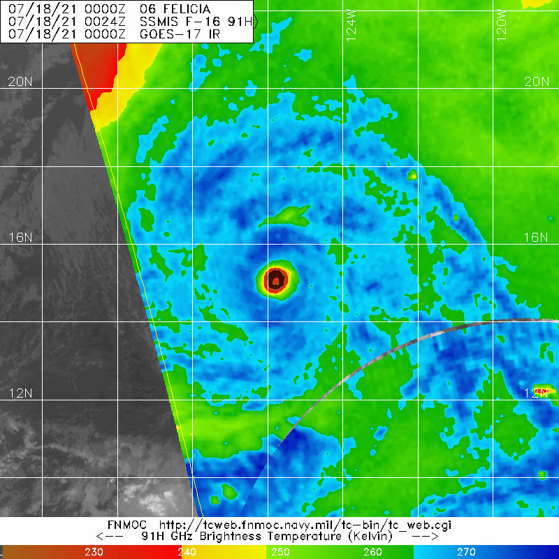
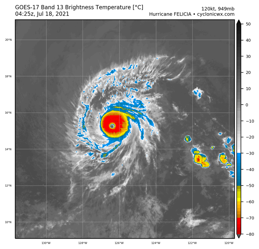
Satellite images indicate that Felicia remains a well-organized
hurricane with an annular structure and a clear eye. However, the
eye temperature has cooled a bit, along with some eyewall
cloud-top warming. Intensity estimates have fallen somewhat, so
the initial wind speed is reduced to 120 kt for this advisory.
Gradually cooling SSTs should cause a general weakening trend with
Felicia during the next day or so. The rate of weakening should
increase sometime Monday due to decreasing instability and a modest
rise in upper-level wind shear, which could assist with dry-air
entrainment near the inner core. Due to the system's small size,
Felicia could also weaken fairly quickly by Tuesday in these
marginal environmental conditions, although this type of scenario
is inherently low confidence. The new forecast remains on the high
side of the guidance but is reduced from the previous one. By the
end of the forecast period, stronger shear should be impacting the
system, and hopefully we will be able to say bye Felicia on
Thursday.
Felicia is moving west-northwestward at about 8 kt. The hurricane
is forecast to turn again toward the west by late Sunday as a
mid-level ridge to the north builds slightly. Felicia should
then turn west-southwestward early in the work week due to the
orientation of an extensive deep-layer ridge centered over the
central Pacific. The spread in the track guidance is very low,
leading to a high confidence track forecast, and the NHC track
forecast is close to the various consensus aids and the last
advisory.
FORECAST POSITIONS AND MAX WINDS
INIT 18/0300Z 15.2N 126.1W 120 KT 140 MPH
12H 18/1200Z 15.6N 127.5W 115 KT 130 MPH
24H 19/0000Z 16.1N 129.5W 105 KT 120 MPH
36H 19/1200Z 16.3N 131.5W 90 KT 105 MPH
48H 20/0000Z 16.3N 133.7W 75 KT 85 MPH
60H 20/1200Z 16.1N 136.1W 60 KT 70 MPH
72H 21/0000Z 15.6N 138.6W 50 KT 60 MPH
96H 22/0000Z 14.6N 144.3W 35 KT 40 MPH
120H 23/0000Z 13.9N 149.5W 30 KT 35 MPH...POST-TROP/REMNT LOW
$$
Forecaster Blake


Chris90 wrote:As a millennial, I love that Blake got that "Bye Felicia!" reference from Friday in the discussion. I also was quite tickled with the hashtag #EyeFelicia that I saw earlier.


Yellow Evan wrote:https://cdn.discordapp.com/attachments/733552978572869632/866156959710052382/image0.png
Will measure after the NBA Finals game but may be approaching T6.5 again.

Yellow Evan wrote:https://cdn.discordapp.com/attachments/733552978572869632/866173739791941642/e9d167be-da50-4e75-bf32-f946b6b8952b.png
If this could somehow thicken T7.0/Cat 5 is in play.
Astromanía wrote:The problem with Hector 2018 was the size as well, right? Sad we don't have recon
Kingarabian wrote:Astromanía wrote:The problem with Hector 2018 was the size as well, right? Sad we don't have recon
No Hector 2018 would've been a Cat.5 but recon wasn't there for the peak. It also had to leave despite not sampling the quadrants with the strongest winds.
Astromanía wrote:Kingarabian wrote:Astromanía wrote:The problem with Hector 2018 was the size as well, right? Sad we don't have recon
No Hector 2018 would've been a Cat.5 but recon wasn't there for the peak. It also had to leave despite not sampling the quadrants with the strongest winds.
So that was just bad luck
Users browsing this forum: No registered users and 62 guests
