2021 Indicators: SST's / SAL / MSLP / Shear / Steering / Instability / Sat Images

This is the general tropical discussion area. Anyone can take their shot at predicting a storms path.

Moderator: S2k Moderators

Forum rules

The posts in this forum are NOT official forecasts and should not be used as such. They are just the opinion of the poster and may or may not be backed by sound meteorological data. They are NOT endorsed by any professional institution or STORM2K. For official information, please refer to products from the National Hurricane Center and National Weather Service.

Help Support Storm2K
Message
Author
User avatar
Category5Kaiju
Category 5
Category 5
Posts: 4095
Joined: Thu Dec 24, 2020 12:45 pm
Location: Seattle

Re: 2021 Indicators: SST's / SAL / MSLP / Shear / Steering / Instability / Sat Images

#1401 Postby Category5Kaiju » Mon Jul 19, 2021 11:50 am

SconnieCane wrote:
Category5Kaiju wrote:
tolakram wrote:Second wettest summer in Cincinnati on record. Hurricane seasons for our wettest years are all over the place.

https://i.imgur.com/LhMRmqX.png

Of the top 5 two had significant hurricanes into Florida. Other than that there doesn't seem to be any correlation with fast or slow seasons.


Haha, 2013's in there...but then you look at 1928, 1932, and 1998, and oh snap.


I think 2013 can pretty much be thrown out as an Atlantic hurricane season analog whenever it pops up, since the thing that caused it to fail was not really part of the usual suite of seasonal "predictors," correct?


Oh yeah of course; much like how 2005 was extreme on one end of how "bad" a season could be, 2013 is the extreme polar opposite. Some people love to bring up "2013" whenever a given season features conditions that are somewhat unfavorable for TCs at any point during such season (but more commonly in the beginning months); I remember seeing such sorts of comments literally every year since 2017 when I first tracked storms (heck, last year when all that dust was around during the summer the 2013 comments on social media never ceased to amaze me). Even this year in May/June when the sst anomalies were marginal and when some person on Twitter made an interesting Tweet about the AMOC slowing down, there were quite a few "will 2021 be another 2013?" kind of comments on social media. However, due to the very specific and rare conditions that caused 2013 to fail miserably (stability, wind shear, THC weakening suddenly, literally bunch together any possible factor that could kill a season and you will get a 2013), I highly doubt that there will be another season like 2013 anytime soon; such would be warmly appreciated given the past active and horrible seasons we've been through, but a season with only 2 hurricanes, 0 majors, and those two hurricanes not even reaching Cat 2 strength during a cool neutral phase? Not sure how well any near future season could replicate or beat how extreme 2013 was.

But yeah bottomline is, until I see it actually occur I will not believe it. Ever since 2017, the "another 2013" comments have failed to materialize each year, and I guarantee you that these comments will appear again in 2022 and 2023 and so forth. It's part of the clockwork of tracking hurricanes!
Last edited by Category5Kaiju on Mon Jul 19, 2021 10:42 pm, edited 1 time in total.
8 likes   
Unless explicitly stated, all info in my posts is based on my own opinions and observations. Tropical storms and hurricanes can be extremely dangerous. Do not think you can beat Mother Nature. Refer to an accredited weather research agency or meteorologist if you need to make serious decisions regarding an approaching storm.

AlphaToOmega
Category 5
Category 5
Posts: 1448
Joined: Sat Jun 26, 2021 10:51 am
Location: Somewhere in Massachusetts

Re: 2021 Indicators: SST's / SAL / MSLP / Shear / Steering / Instability / Sat Images

#1402 Postby AlphaToOmega » Mon Jul 19, 2021 12:12 pm

Looking at the 1938 and 1955 ASO 500mb height anomalies, I am not expecting a hurricane to his us, but I would not be surprised. I think the ridge would put the Mid-Atlantic States at risk, though.
1 likes   

User avatar
Category5Kaiju
Category 5
Category 5
Posts: 4095
Joined: Thu Dec 24, 2020 12:45 pm
Location: Seattle

Re: 2021 Indicators: SST's / SAL / MSLP / Shear / Steering / Instability / Sat Images

#1403 Postby Category5Kaiju » Mon Jul 19, 2021 12:18 pm

AlphaToOmega wrote:Looking at the 1938 and 1955 ASO 500mb height anomalies, I am not expecting a hurricane to his us, but I would not be surprised. I think the ridge would put the Mid-Atlantic States at risk, though.


Yeah starting late August into the rest of the hurricane season I'll be closely watching in Eastern Virginia where I go to college. I have quite a few college friends who went through Isabel in 2003 (which was the last very bad Virginia hurricane, if not the worst), and we've all been wondering when the next "Big One" will hit us. Dorian did a good brush, but a direct hit is something I definitely am not looking forward to and hope it does not happen anytime soon.
1 likes   
Unless explicitly stated, all info in my posts is based on my own opinions and observations. Tropical storms and hurricanes can be extremely dangerous. Do not think you can beat Mother Nature. Refer to an accredited weather research agency or meteorologist if you need to make serious decisions regarding an approaching storm.

Shell Mound
Category 5
Category 5
Posts: 2434
Age: 32
Joined: Thu Sep 07, 2017 3:39 pm
Location: St. Petersburg, FL → Scandinavia

Re: 2021 Indicators: SST's / SAL / MSLP / Shear / Steering / Instability / Sat Images

#1404 Postby Shell Mound » Mon Jul 19, 2021 12:19 pm


Based on the data, there seems to be an inverse correlation between SST in the western Atlantic and (M)H landfalls on Southeast Florida. Am I correct?
0 likes   
CVW / MiamiensisWx / Shell Mound
The posts in this forum are NOT official forecasts and should not be used as such. They are just the opinion of the poster and may or may not be backed by sound meteorological data. They are NOT endorsed by any professional institution or STORM2K. For official information, please refer to products from the NHC and NWS.

User avatar
Category5Kaiju
Category 5
Category 5
Posts: 4095
Joined: Thu Dec 24, 2020 12:45 pm
Location: Seattle

Re: 2021 Indicators: SST's / SAL / MSLP / Shear / Steering / Instability / Sat Images

#1405 Postby Category5Kaiju » Mon Jul 19, 2021 12:57 pm

Image

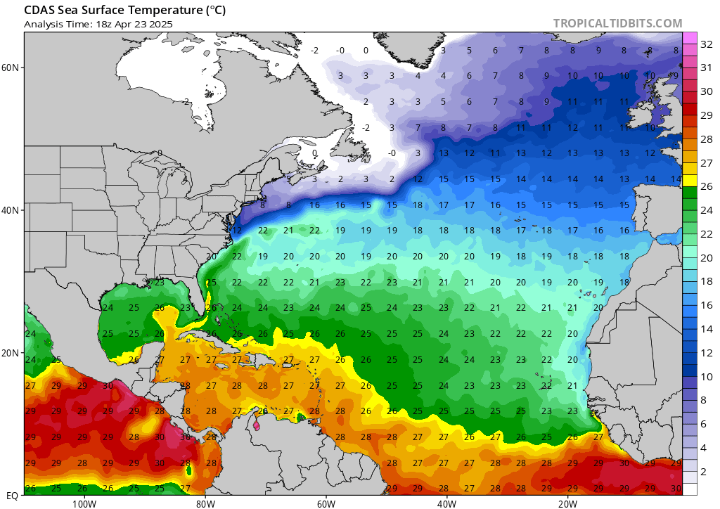
Looks like the 30 degree C waters are slowly materializing....obviously it's great that nothing's brewing right now and for the forseeable future, but the longer nothing is able to significantly disrupt the warm waters (particularly in the Western Atlantic) kind of like Elsa or Claudette did, the more fuel any potential August or September storms would conceivably have if they approach this area.
6 likes   
Unless explicitly stated, all info in my posts is based on my own opinions and observations. Tropical storms and hurricanes can be extremely dangerous. Do not think you can beat Mother Nature. Refer to an accredited weather research agency or meteorologist if you need to make serious decisions regarding an approaching storm.

User avatar
Steve
S2K Supporter
S2K Supporter
Posts: 9620
Joined: Sat Apr 05, 2003 11:41 pm
Location: Not a state-caster

Re: 2021 Indicators: SST's / SAL / MSLP / Shear / Steering / Instability / Sat Images

#1406 Postby Steve » Mon Jul 19, 2021 1:37 pm

toad strangler wrote:I'm not a believer in preceding seasonal precipitation records wet or dry having anything to do with heightened landfall risks come hurricane season.


It's hard to say. Maybe there are some years where the wetter areas telegraph possible openings and places where you can expect prolonged troughiness. And maybe there are some years where the rainy pattern ends up reversing. I don't disbelieve the idea that it's possible or believe that it's not possible. I feel like there needs to be further research. It seems plausible that a generally-repeating MJO would show where it's more likely that it will rain possibly in spots where it has been raining.

The only anecdotal year I have is 2003. It flooded several days in New Orleans that spring. We got TS Bill early in the season, but that was it. So while we did get a TS hit, that was all we saw until the end of 2004 (Matthew in October).
1 likes   

User avatar
Category5Kaiju
Category 5
Category 5
Posts: 4095
Joined: Thu Dec 24, 2020 12:45 pm
Location: Seattle

Re: 2021 Indicators: SST's / SAL / MSLP / Shear / Steering / Instability / Sat Images

#1407 Postby Category5Kaiju » Mon Jul 19, 2021 1:44 pm

Image

Image

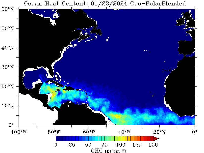
In addition, I would like to revisit the UOHC maps; as you can see, there's a very glaring ball of warmth in the Gulf associated with the Loop Current (in fact, the last time I checked, I cannot seem to find any recent year with that strong of a Loop Eddy signal this early in the season). Come peak season, should that anomalous UOHC spot persist, this definitely would catch my attention.
4 likes   
Unless explicitly stated, all info in my posts is based on my own opinions and observations. Tropical storms and hurricanes can be extremely dangerous. Do not think you can beat Mother Nature. Refer to an accredited weather research agency or meteorologist if you need to make serious decisions regarding an approaching storm.

User avatar
captainbarbossa19
Professional-Met
Professional-Met
Posts: 1092
Age: 27
Joined: Wed Aug 21, 2019 11:09 pm
Location: Beaumont, TX

Re: 2021 Indicators: SST's / SAL / MSLP / Shear / Steering / Instability / Sat Images

#1408 Postby captainbarbossa19 » Mon Jul 19, 2021 2:23 pm

Category5Kaiju wrote:https://www.tropicaltidbits.com/analysis/ocean/cdas-sflux_sst_atl_1.png

Looks like the 30 degree C waters are slowly materializing....obviously it's great that nothing's brewing right now and for the forseeable future, but the longer nothing is able to significantly disrupt the warm waters (particularly in the Western Atlantic) kind of like Elsa or Claudette did, the more fuel any potential August or September storms would conceivably have if they approach this area.


With the ITCZ being further south, I think storms that form will have a harder time recurving. There are few places that are marginal for development, but the Gulf and Western Caribbean look really primed for formation. Also, the semi-permanent pattern this summer has been a ridge to the west and east of the Gulf coast which is leaving a gateway open for storms in the Caribbean to enter. This season could be quite ugly later on. I am rather convinced that there will be a storm (perhaps a major hurricane) threatening the Caribbean, Central America, or the Gulf Coast at some point in August. Florida may be at risk too, but I think that the steering next month may prevent storms going so far east unless the storm passes north of the Caribbean.
1 likes   

AlphaToOmega
Category 5
Category 5
Posts: 1448
Joined: Sat Jun 26, 2021 10:51 am
Location: Somewhere in Massachusetts

Re: 2021 Indicators: SST's / SAL / MSLP / Shear / Steering / Instability / Sat Images

#1409 Postby AlphaToOmega » Mon Jul 19, 2021 2:43 pm

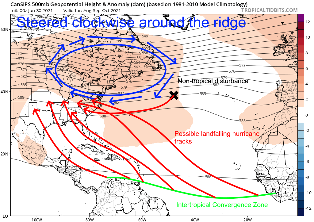
Here is what I think is most likely to happen this hurricane season in terms of storm tracks:
Image
1 likes   

User avatar
AnnularCane
S2K Supporter
S2K Supporter
Posts: 2862
Joined: Thu Jun 08, 2006 9:18 am
Location: Wytheville, VA

Re: 2021 Indicators: SST's / SAL / MSLP / Shear / Steering / Instability / Sat Images

#1410 Postby AnnularCane » Mon Jul 19, 2021 3:11 pm

Don't see too many approach VA Beach from that angle. 8-)
0 likes   
"But it never rained rain. It never snowed snow. And it never blew just wind. It rained things like soup and juice. It snowed mashed potatoes and green peas. And sometimes the wind blew in storms of hamburgers." -- Judi Barrett, Cloudy with a Chance of Meatballs

User avatar
Steve
S2K Supporter
S2K Supporter
Posts: 9620
Joined: Sat Apr 05, 2003 11:41 pm
Location: Not a state-caster

Re: 2021 Indicators: SST's / SAL / MSLP / Shear / Steering / Instability / Sat Images

#1411 Postby Steve » Mon Jul 19, 2021 3:35 pm

AnnularCane wrote:Don't see too many approach VA Beach from that angle. 8-)


Shortcut track. Those are always a trip (hits from the SE over to E) and some of those get pretty strong with the high pressure to their north (e.g. Hugo). Luckily we don't see too many of those tracks or else the east coast would probably get hit harder and more frequently than they do (outside of coastal NC). Move the high pressure 100-300 miles further north, and most of the seaboard is open.
1 likes   

User avatar
Category5Kaiju
Category 5
Category 5
Posts: 4095
Joined: Thu Dec 24, 2020 12:45 pm
Location: Seattle

Re: 2021 Indicators: SST's / SAL / MSLP / Shear / Steering / Instability / Sat Images

#1412 Postby Category5Kaiju » Mon Jul 19, 2021 4:03 pm

If anything I would argue that the luckiest US coast city that is still vulnerable to hurricane strikes is Savannah, Georgia (in fact the entire Georgia coastline I would say is extremely lucky). If I am not mistaken coastal Georgia did not see a major hurricane strike since at least the 19th century, although in recent years with the Gulf Current extremely warm, I am not sure how long this lucky streak will hold; after all all it takes is the right steering patterns and a cooperative atmosphere, with ssts not a major problem I would have to imagine during peak season.
2 likes   
Unless explicitly stated, all info in my posts is based on my own opinions and observations. Tropical storms and hurricanes can be extremely dangerous. Do not think you can beat Mother Nature. Refer to an accredited weather research agency or meteorologist if you need to make serious decisions regarding an approaching storm.

User avatar
toad strangler
S2K Supporter
S2K Supporter
Posts: 4543
Joined: Sun Jul 28, 2013 3:09 pm
Location: Earth
Contact:

Re: 2021 Indicators: SST's / SAL / MSLP / Shear / Steering / Instability / Sat Images

#1413 Postby toad strangler » Mon Jul 19, 2021 4:39 pm

Category5Kaiju wrote:If anything I would argue that the luckiest US coast city that is still vulnerable to hurricane strikes is Savannah, Georgia (in fact the entire Georgia coastline I would say is extremely lucky). If I am not mistaken coastal Georgia did not see a major hurricane strike since at least the 19th century, although in recent years with the Gulf Current extremely warm, I am not sure how long this lucky streak will hold; after all all it takes is the right steering patterns and a cooperative atmosphere, with ssts not a major problem I would have to imagine during peak season.


GA biggest issue is climatology combined with its position on the coast. It’s neatly tucked and nestled in as the furthest western component of the eastern seaboard. At a latitude that sees a super highway climo track of re-curving storms off to the E. Much more likely for GA to be secondarily hit from a storm running inland (Michael) from a GOM landfall. I wouldn’t call GA lucky, I’d call it fortunate to be in the least likely spot on the entire eastern seaboard S of Nantucket Island / Cape Cod to take a direct hit. Not because of luck, but because of location and climatology.
0 likes   

AlphaToOmega
Category 5
Category 5
Posts: 1448
Joined: Sat Jun 26, 2021 10:51 am
Location: Somewhere in Massachusetts

Re: 2021 Indicators: SST's / SAL / MSLP / Shear / Steering / Instability / Sat Images

#1414 Postby AlphaToOmega » Mon Jul 19, 2021 6:00 pm

I cannot help but think 2021 will be 2017 on steroids.
0 likes   

User avatar
SFLcane
S2K Supporter
S2K Supporter
Posts: 10163
Age: 47
Joined: Sat Jun 05, 2010 1:44 pm
Location: Lake Worth Florida

Re: 2021 Indicators: SST's / SAL / MSLP / Shear / Steering / Instability / Sat Images

#1415 Postby SFLcane » Mon Jul 19, 2021 6:16 pm

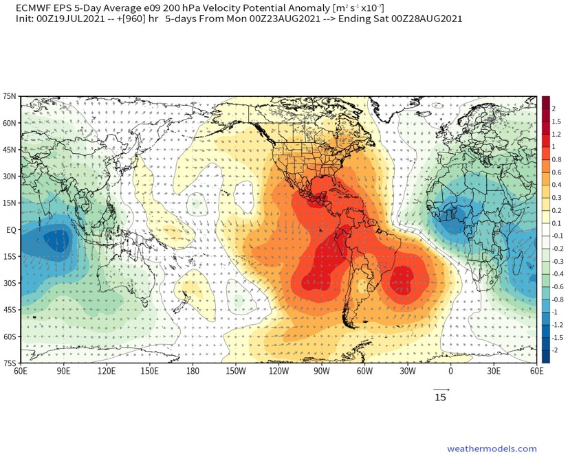
EPS weeklies control with a classic late August active look. Just a matter of time folks!

Image
6 likes   

User avatar
Category5Kaiju
Category 5
Category 5
Posts: 4095
Joined: Thu Dec 24, 2020 12:45 pm
Location: Seattle

Re: 2021 Indicators: SST's / SAL / MSLP / Shear / Steering / Instability / Sat Images

#1416 Postby Category5Kaiju » Mon Jul 19, 2021 6:53 pm

You know, one thing I've learned after hurricane season in general with July this year likely showing little to no more major activity is how truly rare it is to get a Cat 4 or stronger hurricane in July. I remember there was buzz about Elsa potentially achieving that status and I also remember last year how some people thought the insane sst anomalies would mean very strong July cyclones were going to occur, but none of that happened. I guess there's a reason why to date 2005 really remains the only season to feature this kind of freak event. Now I am not sure if any year in the near future will successfully have a Cat 4 or stronger in July, but based on how even the most active and destructive of seasons (1933, 1995, 2004, 2017, and so on) have not seen this kind of event, I guess this really shows how 2005 was pretty much in a crazy, isolated world of its own.
1 likes   
Unless explicitly stated, all info in my posts is based on my own opinions and observations. Tropical storms and hurricanes can be extremely dangerous. Do not think you can beat Mother Nature. Refer to an accredited weather research agency or meteorologist if you need to make serious decisions regarding an approaching storm.

User avatar
aspen
Category 5
Category 5
Posts: 8818
Joined: Sat Oct 12, 2019 7:10 pm
Location: Connecticut, USA

Re: 2021 Indicators: SST's / SAL / MSLP / Shear / Steering / Instability / Sat Images

#1417 Postby aspen » Mon Jul 19, 2021 7:04 pm

SFLcane wrote:EPS weeklies control with a classic late August active look. Just a matter of time folks!

https://i.postimg.cc/9FpcJNym/71-C02382-6531-4163-9-C89-C344-ADFACB81.jpg

That’s both very impressive and concerning for this early in ASO. Do we know for certain what phase the MJO will be in by this time? The suppressive Kelvin Wave should be gone by then, but I think there were some earlier discussions about uncertainty in the exact MJO phase for the end of July/start of August.
0 likes   
Irene '11 Sandy '12 Hermine '16 5/15/2018 Derecho Fay '20 Isaias '20 Elsa '21 Henri '21 Ida '21

I am only a meteorology enthusiast who knows a decent amount about tropical cyclones. Look to the professional mets, the NHC, or your local weather office for the best information.

User avatar
abajan
S2K Supporter
S2K Supporter
Posts: 4230
Joined: Sun Sep 07, 2003 5:10 am
Location: Barbados

Re: 2021 Indicators: SST's / SAL / MSLP / Shear / Steering / Instability / Sat Images

#1418 Postby abajan » Tue Jul 20, 2021 5:03 am

How often do Southern Hemisphere cold fronts cross the equator? And how much influence (if any) do such occurrences exert on the steering of tropical cyclones?

Image
4 likes   

User avatar
SFLcane
S2K Supporter
S2K Supporter
Posts: 10163
Age: 47
Joined: Sat Jun 05, 2010 1:44 pm
Location: Lake Worth Florida

Re: 2021 Indicators: SST's / SAL / MSLP / Shear / Steering / Instability / Sat Images

#1419 Postby SFLcane » Tue Jul 20, 2021 6:15 am

5 likes   

User avatar
SFLcane
S2K Supporter
S2K Supporter
Posts: 10163
Age: 47
Joined: Sat Jun 05, 2010 1:44 pm
Location: Lake Worth Florida

Re: 2021 Indicators: SST's / SAL / MSLP / Shear / Steering / Instability / Sat Images

#1420 Postby SFLcane » Tue Jul 20, 2021 6:21 am

All in all about 3 weeks before the switch flips.
1 likes   


Return to “Talkin' Tropics”

Who is online

Users browsing this forum: Steve H. and 39 guests