#1424 Postby aspen » Tue Jul 20, 2021 7:23 am
SFLcane wrote:Blown Away wrote:SFLcane wrote:All in all about 3 weeks before the switch flips.
Yes, you can feel it in the SFL air, it almost feels like late August/early September already, hint of La Nina conditions out there. It wouldn't surprise me if mid August things start popping.
I expect the waves to start getting perky around August 10th or so. Maybe the pulse will speed up a little bit we'll see. We haven't really had an MDR storm before August 25th or so that lasted in quite a long time.
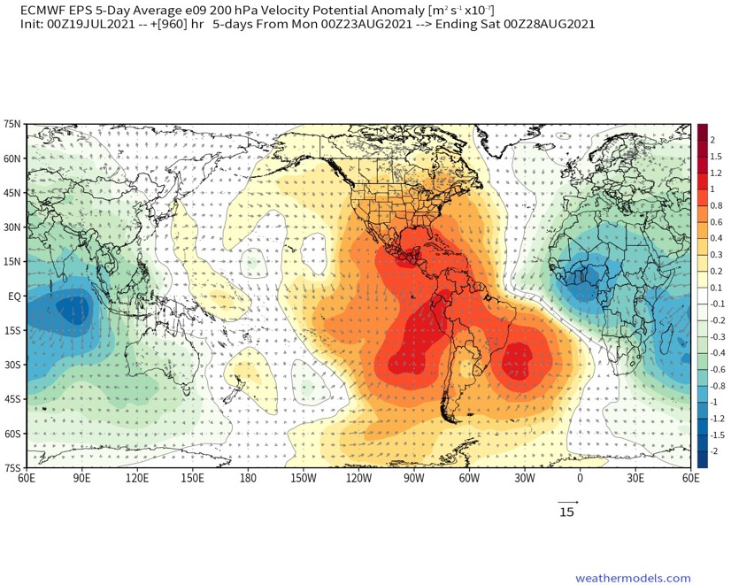
With the suppressive Kelvin Wave moving out within the next 10-14 days and the Euro showing exceptionally favorable VP anomalies for August 3rd-9th, I won’t be surprised if the Atlantic starts to come alive as early as the first week of August. Maybe another AEW system forms, or maybe there’s a strong wave that develops into something significant later. Plus, SSTs are currently favorable for development as East as around 40W as long as the ITCZ remains at a low latitude, and they could be favorable for genesis as north as 15N in the MDR (east of 60W) by early August. In my opinion, the stage seems set for at least one system forming from a tropical wave between when the suppressive CCKW leaves the basin and mid-August.
0 likes
Irene '11 Sandy '12 Hermine '16 5/15/2018 Derecho Fay '20 Isaias '20 Elsa '21 Henri '21 Ida '21
I am only a meteorology enthusiast who knows a decent amount about tropical cyclones. Look to the professional mets, the NHC, or your local weather office for the best information.


