2021 Indicators: SST's / SAL / MSLP / Shear / Steering / Instability / Sat Images

This is the general tropical discussion area. Anyone can take their shot at predicting a storms path.

Moderator: S2k Moderators

Forum rules

The posts in this forum are NOT official forecasts and should not be used as such. They are just the opinion of the poster and may or may not be backed by sound meteorological data. They are NOT endorsed by any professional institution or STORM2K. For official information, please refer to products from the National Hurricane Center and National Weather Service.

Help Support Storm2K
Message
Author
User avatar
Category5Kaiju
Category 5
Category 5
Posts: 4095
Joined: Thu Dec 24, 2020 12:45 pm
Location: Seattle

Re: 2021 Indicators: SST's / SAL / MSLP / Shear / Steering / Instability / Sat Images

#1441 Postby Category5Kaiju » Tue Jul 20, 2021 11:51 am

aspen wrote:

How does this compare to last August? I remember there was also talk about it being quite active, but then it behaved like a normal August with things only kicking off in the last week or two with Laura and Marco.


This year and last year are like the exact opposite. Last year the end of July was a tropical storm feast, with Gonzalo, Hanna, and Isaias forming (with this year expected to be silent). For most of August last year, there was a suppressive phase that only allowed for weak Josephine and Kyle to occur in mid-August, and then activity opened up again near the mid-late month mark with Laura and Marco. This year, at least according to Ben's analysis, the rising pattern in West Africa for most of August is expected to be extremely strong, and I think the distinction is that such VP is stronger than what we saw last year.
9 likes   
Unless explicitly stated, all info in my posts is based on my own opinions and observations. Tropical storms and hurricanes can be extremely dangerous. Do not think you can beat Mother Nature. Refer to an accredited weather research agency or meteorologist if you need to make serious decisions regarding an approaching storm.

User avatar
Stormybajan
Category 1
Category 1
Posts: 448
Joined: Thu May 20, 2021 3:21 pm
Location: Windward Islands

Re: 2021 Indicators: SST's / SAL / MSLP / Shear / Steering / Instability / Sat Images

#1442 Postby Stormybajan » Tue Jul 20, 2021 11:52 am


:double: We really could have a burst of storms and some Hurricanes throughout August just like 2012. What im mostly concerned about is the fact the current MDR SST configuration being a bit more south than usual and the strong high pressure ridge in August may push storms towards land to the caribbean and the Lesser Antilles. Also another problem I see is that with the rising air throughout August..by time September im sure the suppressive MJO and suppressive kelvin wave will have the least effect as the climatological background would be at its optimum, tied in with the cool-neutral ENSO means we really have to watchout for peak season.
2 likes   
Sad West Indies and Manchester United fan ⚽️

User avatar
Stormybajan
Category 1
Category 1
Posts: 448
Joined: Thu May 20, 2021 3:21 pm
Location: Windward Islands

Re: 2021 Indicators: SST's / SAL / MSLP / Shear / Steering / Instability / Sat Images

#1443 Postby Stormybajan » Tue Jul 20, 2021 11:57 am


Why does it feel like every year since 2017 this chart has screamed at us Atlantic Instability is below average :lol: , yet, we've still had above average seasons from then until now and I dont see that pattern changing this year either
6 likes   
Sad West Indies and Manchester United fan ⚽️

User avatar
SFLcane
S2K Supporter
S2K Supporter
Posts: 10163
Age: 47
Joined: Sat Jun 05, 2010 1:44 pm
Location: Lake Worth Florida

Re: 2021 Indicators: SST's / SAL / MSLP / Shear / Steering / Instability / Sat Images

#1444 Postby SFLcane » Tue Jul 20, 2021 12:17 pm

Stormybajan wrote:


Why does it feel like every year since 2017 this chart has screamed at us Atlantic Instability is below average :lol: , yet, we've still had above average seasons from then until now and I dont see that pattern changing this year either


It's definitely been a problem especially early in the season. That's why August hasn't really done much recently. We shall see
1 likes   

User avatar
SFLcane
S2K Supporter
S2K Supporter
Posts: 10163
Age: 47
Joined: Sat Jun 05, 2010 1:44 pm
Location: Lake Worth Florida

Re: 2021 Indicators: SST's / SAL / MSLP / Shear / Steering / Instability / Sat Images

#1445 Postby SFLcane » Tue Jul 20, 2021 12:31 pm

Thought I’d share this from Crown weather.

Posted on Tuesday 7/20/2021: No tropical development is expected across the Atlantic, Caribbean and Gulf of Mexico for at least the next 7 to 10 days.

Beyond this, we will likely see a pattern change towards a marked increase for tropical development as we head into early and mid August.

An upward motion pulse of the Madden Julian Oscillation is expected to push into the Atlantic Basin by the very end of this month and the beginning of August. Once this occurs, the conditions across the Atlantic will become favorable for development beginning during the first part of August. These favorable conditions for development are then expected to last through all of August and maybe as long as the very start of September.

This means that August could be a very active month for hurricane development across the Atlantic, Caribbean and Gulf of Mexico.

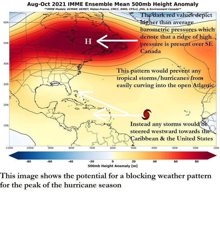
If that wasn't bad enough news, the latest ensemble guidance are forecasting a very troubling upper air pattern for the peak of the hurricane season – in fact, it’s downright ugly!! These guidance members are showing a blocking high pressure system to set up over southeastern Canada and a setup like this is usually associated with much more frequent hurricane landfalls on the US Coastline and in the Caribbean.

It’s probably best to use the quiet that we will have for the next ten days or so to make sure you are ready when the activity picks up in earnest.

One step you could take is to subscribe to our Crown Weather Plus subscription plan, so that you are well informed, well in advance of any tropical systems. To learn more of how to subscribe, just go to https://crownweather.com/index.php/cws- ... scription/ .

I cannot emphasize enough of how very busy it will likely get during August into early September in terms of tropical storm and hurricane activity. The weather pattern that looks to set up is such that very few storms will curve out into the open Atlantic, but instead head towards land. It still looks downright ugly and dangerous in terms of hurricane landfalls this season.

Image
7 likes   

User avatar
cycloneye
Admin
Admin
Posts: 145294
Age: 68
Joined: Thu Oct 10, 2002 10:54 am
Location: San Juan, Puerto Rico

Re: 2021 Indicators: SST's / SAL / MSLP / Shear / Steering / Instability / Sat Images

#1446 Postby cycloneye » Tue Jul 20, 2021 12:52 pm

cycloneye wrote:
aspen wrote:

How does this compare to last August? I remember there was also talk about it being quite active, but then it behaved like a normal August with things only kicking off in the last week or two with Laura and Marco.


Unless someone posts archives about that, I may have to search Mr Nolls tweets of 2020.


From July 2020 a series of tweets from Nr Noll and Webb:

 https://twitter.com/webberweather/status/1280574478041440263


 https://twitter.com/webberweather/status/1283024424111951872


 https://twitter.com/BenNollWeather/status/1283046089415725056


 https://twitter.com/webberweather/status/1285243641309650945


July 20

 https://twitter.com/BenNollWeather/status/1286300036306018308


July 23
2 likes   
Visit the Caribbean-Central America Weather Thread where you can find at first post web cams,radars
and observations from Caribbean basin members Click Here

Shell Mound
Category 5
Category 5
Posts: 2434
Age: 32
Joined: Thu Sep 07, 2017 3:39 pm
Location: St. Petersburg, FL → Scandinavia

Re: 2021 Indicators: SST's / SAL / MSLP / Shear / Steering / Instability / Sat Images

#1447 Postby Shell Mound » Tue Jul 20, 2021 1:40 pm

AlphaToOmega wrote:I cannot help but think 2021 will be 2017 on steroids.

That’s a very bold call. 2017 featured the highest monthly ACE in September on record. Also, August 2004, if I recall correctly, featured one of the highest ACE indices for the month on record. To match or surpass either August 2004 or September 2017 (or both), 2021 would need to generate numerous long-tracking major hurricanes during either or both of those months, as opposed to short-lived ones like those of 2020. Having several weak and/or short-lived systems would not count. Therefore, 2021 would need to feature a much warmer MDR than is currently present.
1 likes   
CVW / MiamiensisWx / Shell Mound
The posts in this forum are NOT official forecasts and should not be used as such. They are just the opinion of the poster and may or may not be backed by sound meteorological data. They are NOT endorsed by any professional institution or STORM2K. For official information, please refer to products from the NHC and NWS.

AutoPenalti
Category 5
Category 5
Posts: 4030
Age: 29
Joined: Mon Aug 17, 2015 4:16 pm
Location: Ft. Lauderdale, Florida

Re: 2021 Indicators: SST's / SAL / MSLP / Shear / Steering / Instability / Sat Images

#1448 Postby AutoPenalti » Tue Jul 20, 2021 1:43 pm


Has that chart ever gone above the mean?
1 likes   
The posts in this forum are NOT official forecasts and should not be used as such. They are just the opinion of the poster and may or may not be backed by sound meteorological data. They are NOT endorsed by any professional institution or STORM2K. For official information, please refer to products from the NHC and NWS.


Model Runs Cheat Sheet:
GFS (5:30 AM/PM, 11:30 AM/PM)
HWRF, GFDL, UKMET, NAVGEM (6:30-8:00 AM/PM, 12:30-2:00 AM/PM)
ECMWF (1:45 AM/PM)

TCVN
is a weighted averaged

User avatar
Category5Kaiju
Category 5
Category 5
Posts: 4095
Joined: Thu Dec 24, 2020 12:45 pm
Location: Seattle

Re: 2021 Indicators: SST's / SAL / MSLP / Shear / Steering / Instability / Sat Images

#1449 Postby Category5Kaiju » Tue Jul 20, 2021 1:43 pm

 https://twitter.com/webberweather/status/1280574478041440263


Image

And this is a good example of why you cannot rely on precip anomaly maps as if they are some sort of crystal ball that can truly forecast exact storm tracks and where the major hurricanes will be.
1 likes   
Unless explicitly stated, all info in my posts is based on my own opinions and observations. Tropical storms and hurricanes can be extremely dangerous. Do not think you can beat Mother Nature. Refer to an accredited weather research agency or meteorologist if you need to make serious decisions regarding an approaching storm.

User avatar
SFLcane
S2K Supporter
S2K Supporter
Posts: 10163
Age: 47
Joined: Sat Jun 05, 2010 1:44 pm
Location: Lake Worth Florida

Re: 2021 Indicators: SST's / SAL / MSLP / Shear / Steering / Instability / Sat Images

#1450 Postby SFLcane » Tue Jul 20, 2021 1:52 pm

Category5Kaiju wrote:https://twitter.com/webberweather/status/1280574478041440263

https://www.air-worldwide.com/siteassets/airimages/publications/air_currents/2020/hurricaneseason2020_figure1.png

And this is a good example of why you cannot rely on precip anomaly maps as if they are some sort of crystal ball that can truly forecast exact storm tracks and where the major hurricanes will be.


Hmmm the July NMME showed gulf madness quite well.

Image
1 likes   

User avatar
SFLcane
S2K Supporter
S2K Supporter
Posts: 10163
Age: 47
Joined: Sat Jun 05, 2010 1:44 pm
Location: Lake Worth Florida

Re: 2021 Indicators: SST's / SAL / MSLP / Shear / Steering / Instability / Sat Images

#1451 Postby SFLcane » Tue Jul 20, 2021 1:55 pm

Maybe July NMME is more reliable. It’s not perfect but not Way off. We shall see
0 likes   

User avatar
aspen
Category 5
Category 5
Posts: 8818
Joined: Sat Oct 12, 2019 7:10 pm
Location: Connecticut, USA

Re: 2021 Indicators: SST's / SAL / MSLP / Shear / Steering / Instability / Sat Images

#1452 Postby aspen » Tue Jul 20, 2021 2:00 pm

AutoPenalti wrote:

Has that chart ever gone above the mean?

I think all of the seasons in the most recent active streak have stayed below that average. People were talking about this last year, and I bet also in 2019, 2018, and 2017.
4 likes   
Irene '11 Sandy '12 Hermine '16 5/15/2018 Derecho Fay '20 Isaias '20 Elsa '21 Henri '21 Ida '21

I am only a meteorology enthusiast who knows a decent amount about tropical cyclones. Look to the professional mets, the NHC, or your local weather office for the best information.

User avatar
Category5Kaiju
Category 5
Category 5
Posts: 4095
Joined: Thu Dec 24, 2020 12:45 pm
Location: Seattle

Re: 2021 Indicators: SST's / SAL / MSLP / Shear / Steering / Instability / Sat Images

#1453 Postby Category5Kaiju » Tue Jul 20, 2021 2:01 pm

aspen wrote:
AutoPenalti wrote:

Has that chart ever gone above the mean?

I think all of the seasons in the most recent active streak have stayed below that average. People were talking about this last year, and I bet also in 2019, 2018, and 2017.


I wonder when the last season was when the chart actually showed near or above average
0 likes   
Unless explicitly stated, all info in my posts is based on my own opinions and observations. Tropical storms and hurricanes can be extremely dangerous. Do not think you can beat Mother Nature. Refer to an accredited weather research agency or meteorologist if you need to make serious decisions regarding an approaching storm.

User avatar
SFLcane
S2K Supporter
S2K Supporter
Posts: 10163
Age: 47
Joined: Sat Jun 05, 2010 1:44 pm
Location: Lake Worth Florida

Re: 2021 Indicators: SST's / SAL / MSLP / Shear / Steering / Instability / Sat Images

#1454 Postby SFLcane » Tue Jul 20, 2021 2:04 pm

aspen wrote:
AutoPenalti wrote:

Has that chart ever gone above the mean?

I think all of the seasons in the most recent active streak have stayed below that average. People were talking about this last year, and I bet also in 2019, 2018, and 2017.


You can see the spike back up when the basin got busy in late August 2017.


Image
0 likes   

User avatar
cycloneye
Admin
Admin
Posts: 145294
Age: 68
Joined: Thu Oct 10, 2002 10:54 am
Location: San Juan, Puerto Rico

Re: 2021 Indicators: SST's / SAL / MSLP / Shear / Steering / Instability / Sat Images

#1455 Postby cycloneye » Tue Jul 20, 2021 2:35 pm

For the members who may want to go back to the 2020 indicators thread to see how were the factors leading to the busy season it was, here it is. Dont look at the first post because there are all the satelites and other graphics that continue to update in 2021.

viewtopic.php?f=31&t=120763
0 likes   
Visit the Caribbean-Central America Weather Thread where you can find at first post web cams,radars
and observations from Caribbean basin members Click Here

User avatar
aspen
Category 5
Category 5
Posts: 8818
Joined: Sat Oct 12, 2019 7:10 pm
Location: Connecticut, USA

Re: 2021 Indicators: SST's / SAL / MSLP / Shear / Steering / Instability / Sat Images

#1456 Postby aspen » Tue Jul 20, 2021 2:55 pm

cycloneye wrote:For the members who may want to go back to the 2020 indicators thread to see how were the factors leading to the busy season it was, here it is. Dont look at the first post because there are all the satelites and other graphics that continue to update in 2021.

viewtopic.php?f=31&t=120763

Something interesting I saw: around July 10th, the ITCZ was further south than normal, and several users — including me — thought there was a possibility of a Caribbean low-rider due to the position of the ITCZ, all of the enhanced VP anomalies for the next 20 days, and the very warm Caribbean. However, USTropics posted that warming of the MDR over the next 2-3 weeks would cause a pressure gradient that would move the ITCZ north. In the end, there were no August Caribbean long-trackers, and the ITCZ was further north than average like 2018 and 2019.
9 likes   
Irene '11 Sandy '12 Hermine '16 5/15/2018 Derecho Fay '20 Isaias '20 Elsa '21 Henri '21 Ida '21

I am only a meteorology enthusiast who knows a decent amount about tropical cyclones. Look to the professional mets, the NHC, or your local weather office for the best information.

AlphaToOmega
Category 5
Category 5
Posts: 1448
Joined: Sat Jun 26, 2021 10:51 am
Location: Somewhere in Massachusetts

Re: 2021 Indicators: SST's / SAL / MSLP / Shear / Steering / Instability / Sat Images

#1457 Postby AlphaToOmega » Tue Jul 20, 2021 5:30 pm

Very important to note: the JMA is forecasting a TNA of 0.38 C above normal during September 2021 (+TNA). September 2020 had a weaker +TNA of 0.31 above normal. This does not mean that 2021 will 100% be more active than 2020, but I would not rule it out just yet.

Source: https://ds.data.jma.go.jp/tcc/tcc/products/model/indices/3-mon/indices1/shisu_forecast.php
0 likes   

User avatar
Category5Kaiju
Category 5
Category 5
Posts: 4095
Joined: Thu Dec 24, 2020 12:45 pm
Location: Seattle

Re: 2021 Indicators: SST's / SAL / MSLP / Shear / Steering / Instability / Sat Images

#1458 Postby Category5Kaiju » Tue Jul 20, 2021 5:59 pm

 https://twitter.com/AndyHazelton/status/1417553138211561476


https://weather.us/cyclone-tracks

So it looks like there's a low but non-zero chance July manages to squeak in one small storm before August arrives....not exepecting anything to happen of course, but these systems are notoriously hard to predict, so...we'll see
0 likes   
Unless explicitly stated, all info in my posts is based on my own opinions and observations. Tropical storms and hurricanes can be extremely dangerous. Do not think you can beat Mother Nature. Refer to an accredited weather research agency or meteorologist if you need to make serious decisions regarding an approaching storm.

User avatar
SFLcane
S2K Supporter
S2K Supporter
Posts: 10163
Age: 47
Joined: Sat Jun 05, 2010 1:44 pm
Location: Lake Worth Florida

Re: 2021 Indicators: SST's / SAL / MSLP / Shear / Steering / Instability / Sat Images

#1459 Postby SFLcane » Tue Jul 20, 2021 6:33 pm

Not expecting much till mid August at earliest.

 https://twitter.com/webberweather/status/1417603827574915078


0 likes   

User avatar
aspen
Category 5
Category 5
Posts: 8818
Joined: Sat Oct 12, 2019 7:10 pm
Location: Connecticut, USA

Re: 2021 Indicators: SST's / SAL / MSLP / Shear / Steering / Instability / Sat Images

#1460 Postby aspen » Tue Jul 20, 2021 6:42 pm

SFLcane wrote:Not expecting much till mid August at earliest.

https://twitter.com/webberweather/status/1417603827574915078

Rip any attempted Caribbean Cruisers if that verifies. Shear seems low enough north of the Caribbean if anything gets up there, but with a south ITCZ and a huge blocking high, that might not happen.
0 likes   
Irene '11 Sandy '12 Hermine '16 5/15/2018 Derecho Fay '20 Isaias '20 Elsa '21 Henri '21 Ida '21

I am only a meteorology enthusiast who knows a decent amount about tropical cyclones. Look to the professional mets, the NHC, or your local weather office for the best information.


Return to “Talkin' Tropics”

Who is online

Users browsing this forum: KeysRedWine and 39 guests