2021 Indicators: SST's / SAL / MSLP / Shear / Steering / Instability / Sat Images

This is the general tropical discussion area. Anyone can take their shot at predicting a storms path.

Moderator: S2k Moderators

Forum rules

The posts in this forum are NOT official forecasts and should not be used as such. They are just the opinion of the poster and may or may not be backed by sound meteorological data. They are NOT endorsed by any professional institution or STORM2K. For official information, please refer to products from the National Hurricane Center and National Weather Service.

Help Support Storm2K
Message
Author
User avatar
SFLcane
S2K Supporter
S2K Supporter
Posts: 10163
Age: 47
Joined: Sat Jun 05, 2010 1:44 pm
Location: Lake Worth Florida

Re: 2021 Indicators: SST's / SAL / MSLP / Shear / Steering / Instability / Sat Images

#1581 Postby SFLcane » Fri Jul 23, 2021 7:13 am

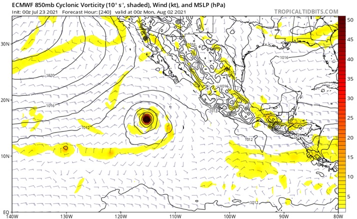
aspen wrote:The setup in the WPac looks like it’ll only allow for weak sloppy systems, and the models have really backed off with the potential strong EPac system that was originally forecast to start developing in a few days. If both Pacific basins end up being rather inactive like this for the next 1-2 weeks, it would probably lower the shear in the Atlantic and allow for activity in the tropics to start once the suppressive CCKW/MJO phase move out at the very end of July and the start of August.


What are you looking at?

Image
2 likes   

User avatar
aspen
Category 5
Category 5
Posts: 8818
Joined: Sat Oct 12, 2019 7:10 pm
Location: Connecticut, USA

Re: 2021 Indicators: SST's / SAL / MSLP / Shear / Steering / Instability / Sat Images

#1582 Postby aspen » Fri Jul 23, 2021 9:10 am

SFLcane wrote:
aspen wrote:The setup in the WPac looks like it’ll only allow for weak sloppy systems, and the models have really backed off with the potential strong EPac system that was originally forecast to start developing in a few days. If both Pacific basins end up being rather inactive like this for the next 1-2 weeks, it would probably lower the shear in the Atlantic and allow for activity in the tropics to start once the suppressive CCKW/MJO phase move out at the very end of July and the start of August.


What are you looking at?

https://i.postimg.cc/QCwgRD7h/5-EEDEAD9-33-F4-44-B3-B22-C-6-D7-A8-E8-E8531.jpg

That system used to be much earlier on the GFS, with development starting as early as in a few days.
0 likes   
Irene '11 Sandy '12 Hermine '16 5/15/2018 Derecho Fay '20 Isaias '20 Elsa '21 Henri '21 Ida '21

I am only a meteorology enthusiast who knows a decent amount about tropical cyclones. Look to the professional mets, the NHC, or your local weather office for the best information.

User avatar
Steve
S2K Supporter
S2K Supporter
Posts: 9621
Joined: Sat Apr 05, 2003 11:41 pm
Location: Not a state-caster

Re: 2021 Indicators: SST's / SAL / MSLP / Shear / Steering / Instability / Sat Images

#1583 Postby Steve » Fri Jul 23, 2021 9:31 am

MJO is in Phase 6. Most of the models expect it to drop back into the circle over the next 10-14 days - but down to the bottom of the circle. Graphs are never exact, and there can be development while the signal is neutral. I'd like to see if they trend toward looping back up into Phase 6/7 or if they determine it's going to go out of the circle into Phases 1 or 2. And what happens then? Some of the larger maps show a favorable pulse in Week #2. This doesn't always mean instant storms. Sometimes it seems like pulses in the middle of the season but before the heart are table setters, and then you get 2 weeks or so after passage where things are very favorable in the Atlantic. Whatever happens, we're getting close. Long term GFS shows waves emerging after 2 weeks. So be ready if we get a pulse before the prime of the season.
2 likes   

User avatar
chaser1
S2K Supporter
S2K Supporter
Posts: 5464
Age: 64
Joined: Sat Oct 15, 2005 5:59 pm
Location: Longwood, Fl

Re: 2021 Indicators: SST's / SAL / MSLP / Shear / Steering / Instability / Sat Images

#1584 Postby chaser1 » Fri Jul 23, 2021 10:05 am

Steve wrote:MJO is in Phase 6. Most of the models expect it to drop back into the circle over the next 10-14 days - but down to the bottom of the circle. Graphs are never exact, and there can be development while the signal is neutral. I'd like to see if they trend toward looping back up into Phase 6/7 or if they determine it's going to go out of the circle into Phases 1 or 2. And what happens then? Some of the larger maps show a favorable pulse in Week #2. This doesn't always mean instant storms. Sometimes it seems like pulses in the middle of the season but before the heart are table setters, and then you get 2 weeks or so after passage where things are very favorable in the Atlantic. Whatever happens, we're getting close. Long term GFS shows waves emerging after 2 weeks. So be ready if we get a pulse before the prime of the season.


Good points Steve; I'm trying to remember specific examples but in some over-active years where the back-ground state was otherwise favorable, the MJO remaining within the circle might have been viewed in advance as neutral at best conditions for Atlantic activity. What I recall playing out however was a continuous level of active development in the Atlantic basin during such periods. What i'd be curious to research is whether such activity was more pronounced in primarily lower latitudes or more or less equally spread over tropical and sub-tropical latitudes. My guess is perhaps the latter though. Of course, other regionalized factors contributed too such as upper level conditions, SST's etc. I agree though, we are getting close. My guess is that it'll be nearer to that 10 day point then later but either way, we probably won't have to wait too long to find out.
1 likes   
Andy D

(For official information, please refer to the NHC and NWS products.)

User avatar
Category5Kaiju
Category 5
Category 5
Posts: 4097
Joined: Thu Dec 24, 2020 12:45 pm
Location: Seattle

Re: 2021 Indicators: SST's / SAL / MSLP / Shear / Steering / Instability / Sat Images

#1585 Postby Category5Kaiju » Fri Jul 23, 2021 11:34 am

0 likes   
Unless explicitly stated, all info in my posts is based on my own opinions and observations. Tropical storms and hurricanes can be extremely dangerous. Do not think you can beat Mother Nature. Refer to an accredited weather research agency or meteorologist if you need to make serious decisions regarding an approaching storm.

User avatar
crownweather
S2K Supporter
S2K Supporter
Posts: 595
Age: 50
Joined: Sat Aug 12, 2006 9:21 am
Location: Sturbridge, Massachusetts
Contact:

Re: 2021 Indicators: SST's / SAL / MSLP / Shear / Steering / Instability / Sat Images

#1586 Postby crownweather » Fri Jul 23, 2021 11:40 am

I thought Eric's follow up reply was even more interesting regarding the analog look for August.

 https://twitter.com/webberweather/status/1418607765258387464


1 likes   
Rob Lightbown
Crown Weather Services
https://crownweather.com

User avatar
SFLcane
S2K Supporter
S2K Supporter
Posts: 10163
Age: 47
Joined: Sat Jun 05, 2010 1:44 pm
Location: Lake Worth Florida

Re: 2021 Indicators: SST's / SAL / MSLP / Shear / Steering / Instability / Sat Images

#1587 Postby SFLcane » Fri Jul 23, 2021 11:58 am

crownweather wrote:I thought Eric's follow up reply was even more interesting regarding the analog look for August.

https://twitter.com/webberweather/status/1418607765258387464


We’ll this is interesting. Especially the Mdr precipitation anomalies further north.
0 likes   

User avatar
SFLcane
S2K Supporter
S2K Supporter
Posts: 10163
Age: 47
Joined: Sat Jun 05, 2010 1:44 pm
Location: Lake Worth Florida

Re: 2021 Indicators: SST's / SAL / MSLP / Shear / Steering / Instability / Sat Images

#1588 Postby SFLcane » Fri Jul 23, 2021 12:03 pm

The break in the ridge is over Florida i think Elsa will not be the last one tracking similar.
0 likes   

User avatar
captainbarbossa19
Professional-Met
Professional-Met
Posts: 1092
Age: 27
Joined: Wed Aug 21, 2019 11:09 pm
Location: Beaumont, TX

Re: 2021 Indicators: SST's / SAL / MSLP / Shear / Steering / Instability / Sat Images

#1589 Postby captainbarbossa19 » Fri Jul 23, 2021 12:19 pm

SFLcane wrote:
crownweather wrote:I thought Eric's follow up reply was even more interesting regarding the analog look for August.

https://twitter.com/webberweather/status/1418607765258387464


We’ll this is interesting. Especially the Mdr precipitation anomalies further north.


That band in the Caribbean towards the Gulf is somewhat alarming too. Hopefully the western Gulf will not be hit so hard this year like last year.
0 likes   

MarioProtVI
Category 4
Category 4
Posts: 935
Age: 24
Joined: Sun Sep 29, 2019 7:33 pm
Location: New Jersey

Re: 2021 Indicators: SST's / SAL / MSLP / Shear / Steering / Instability / Sat Images

#1590 Postby MarioProtVI » Fri Jul 23, 2021 12:32 pm

Shell Mound wrote:
AlphaToOmega wrote:
SFLcane wrote:Maybe we’re skipping this season? Lol…

No TCs through September 5 on the EPS control.

https://i.postimg.cc/Vvvcw0Gn/8-B884703-C69-B-4-E72-A970-A0-B34-E90-C874.png

Watch as someone uses this as evidence that the season will be inactive :lol:

I could have sworn a while ago that the model was showing an MDR storm circa August 22.

The EPS, whether long-range or otherwise, tends to miss a lot of weak systems and marginal hurricanes, but it does well in terms of gauging the potential for intense activity. So I think it can be used to assess the potential for higher-end long-trackers during the peak of the season. In this case it agrees relatively well with the BoM’s ACCESS, the JMA, and the CFSv2 in suggesting a suppressed ITCZ, a strong TUTT, a fairly coolish MDR vs. the subtropics, and possible sinking air over the basin during the “traditional” peak. Also, the balance of the guidance suggests some additional VWS from EPAC convection/activity during the same timeframe, especially through the first half of September. So while I wouldn’t “cancel” the season per se, I think there is a good chance that it will underperform relative to expectations/forecasts. We shall see.

I can almost guarantee this will age like milk just like the things you said last year about 2020. Come November I think you will probably be off in a lot of ways no offense. The fact Elsa existed shows the MDR might be more active this year compared to last.
11 likes   

User avatar
Category5Kaiju
Category 5
Category 5
Posts: 4097
Joined: Thu Dec 24, 2020 12:45 pm
Location: Seattle

Re: 2021 Indicators: SST's / SAL / MSLP / Shear / Steering / Instability / Sat Images

#1591 Postby Category5Kaiju » Fri Jul 23, 2021 12:55 pm

MarioProtVI wrote:
Shell Mound wrote:
AlphaToOmega wrote:Watch as someone uses this as evidence that the season will be inactive :lol:

I could have sworn a while ago that the model was showing an MDR storm circa August 22.

The EPS, whether long-range or otherwise, tends to miss a lot of weak systems and marginal hurricanes, but it does well in terms of gauging the potential for intense activity. So I think it can be used to assess the potential for higher-end long-trackers during the peak of the season. In this case it agrees relatively well with the BoM’s ACCESS, the JMA, and the CFSv2 in suggesting a suppressed ITCZ, a strong TUTT, a fairly coolish MDR vs. the subtropics, and possible sinking air over the basin during the “traditional” peak. Also, the balance of the guidance suggests some additional VWS from EPAC convection/activity during the same timeframe, especially through the first half of September. So while I wouldn’t “cancel” the season per se, I think there is a good chance that it will underperform relative to expectations/forecasts. We shall see.

I can almost guarantee this will age like milk just like the things you said last year about 2020. Come November I think you will probably be off in a lot of ways no offense. The fact Elsa existed shows the MDR shows that it might be more active this year compared to last.


At least according to the discussions I have had with ShellMound a few pages earlier, from what I understand, ShellMound believes that we're in an -AMO that is expected to somewhat contribute to the predictions of the hostile conditions in the Atlantic despite a favorable La Nina background state. However, while I guess I am trying not to overthink a variety of different possibilities, given the more recent patterns in Atlantic hurricane season years switching from -AMO to +AMO during peak season (with all of such years being above average with several destructive and memorable hurricanes), I am going to be frank and say that I am truly skeptical that 2021 will suddenly express a completely different pattern change than what we have been predicting and expecting and end up underperforming massively, and I am going to cling to the idea that this season has a good chance of being very active. Now if August and September are dead and not active then maybe I'll change my mind, but I am pretty sure that that will not come to fruition at all. Not to mention the WPAC and EPAC have not recently seen any major burst in activity with an onslaught of very powerful cyclones, and as a result of this I am confident to believe that in the end it will be the Atlantic that is the favored basin for high levels of activity.
3 likes   
Unless explicitly stated, all info in my posts is based on my own opinions and observations. Tropical storms and hurricanes can be extremely dangerous. Do not think you can beat Mother Nature. Refer to an accredited weather research agency or meteorologist if you need to make serious decisions regarding an approaching storm.

AxaltaRacing24
Category 5
Category 5
Posts: 1753
Age: 25
Joined: Wed Jul 27, 2016 11:14 am
Location: Jupiter, FL

Re: 2021 Indicators: SST's / SAL / MSLP / Shear / Steering / Instability / Sat Images

#1592 Postby AxaltaRacing24 » Fri Jul 23, 2021 1:18 pm

MarioProtVI wrote:
Shell Mound wrote:
AlphaToOmega wrote:Watch as someone uses this as evidence that the season will be inactive :lol:

I could have sworn a while ago that the model was showing an MDR storm circa August 22.

The EPS, whether long-range or otherwise, tends to miss a lot of weak systems and marginal hurricanes, but it does well in terms of gauging the potential for intense activity. So I think it can be used to assess the potential for higher-end long-trackers during the peak of the season. In this case it agrees relatively well with the BoM’s ACCESS, the JMA, and the CFSv2 in suggesting a suppressed ITCZ, a strong TUTT, a fairly coolish MDR vs. the subtropics, and possible sinking air over the basin during the “traditional” peak. Also, the balance of the guidance suggests some additional VWS from EPAC convection/activity during the same timeframe, especially through the first half of September. So while I wouldn’t “cancel” the season per se, I think there is a good chance that it will underperform relative to expectations/forecasts. We shall see.

I can almost guarantee this will age like milk just like the things you said last year about 2020. Come November I think you will probably be off in a lot of ways no offense. The fact Elsa existed shows the MDR might be more active this year compared to last.

Also important to note that conditions will become more favorable this season towards the peak, as -ESNO and a more favorable SST pattern will likely join forces in making us forget about a “dead” July. Enjoy the break, because I doubt we will still be in it come 4 weeks time.
3 likes   

User avatar
captainbarbossa19
Professional-Met
Professional-Met
Posts: 1092
Age: 27
Joined: Wed Aug 21, 2019 11:09 pm
Location: Beaumont, TX

Re: 2021 Indicators: SST's / SAL / MSLP / Shear / Steering / Instability / Sat Images

#1593 Postby captainbarbossa19 » Fri Jul 23, 2021 2:54 pm

AxaltaRacing24 wrote:
MarioProtVI wrote:
Shell Mound wrote:The EPS, whether long-range or otherwise, tends to miss a lot of weak systems and marginal hurricanes, but it does well in terms of gauging the potential for intense activity. So I think it can be used to assess the potential for higher-end long-trackers during the peak of the season. In this case it agrees relatively well with the BoM’s ACCESS, the JMA, and the CFSv2 in suggesting a suppressed ITCZ, a strong TUTT, a fairly coolish MDR vs. the subtropics, and possible sinking air over the basin during the “traditional” peak. Also, the balance of the guidance suggests some additional VWS from EPAC convection/activity during the same timeframe, especially through the first half of September. So while I wouldn’t “cancel” the season per se, I think there is a good chance that it will underperform relative to expectations/forecasts. We shall see.

I can almost guarantee this will age like milk just like the things you said last year about 2020. Come November I think you will probably be off in a lot of ways no offense. The fact Elsa existed shows the MDR might be more active this year compared to last.

Also important to note that conditions will become more favorable this season towards the peak, as -ESNO and a more favorable SST pattern will likely join forces in making us forget about a “dead” July. Enjoy the break, because I doubt we will still be in it come 4 weeks time.


And considering we have a chance of seeing Fred in a few days, July is quite far from dead.
0 likes   

User avatar
Category5Kaiju
Category 5
Category 5
Posts: 4097
Joined: Thu Dec 24, 2020 12:45 pm
Location: Seattle

Re: 2021 Indicators: SST's / SAL / MSLP / Shear / Steering / Instability / Sat Images

#1594 Postby Category5Kaiju » Fri Jul 23, 2021 2:57 pm

captainbarbossa19 wrote:
AxaltaRacing24 wrote:
MarioProtVI wrote:I can almost guarantee this will age like milk just like the things you said last year about 2020. Come November I think you will probably be off in a lot of ways no offense. The fact Elsa existed shows the MDR might be more active this year compared to last.

Also important to note that conditions will become more favorable this season towards the peak, as -ESNO and a more favorable SST pattern will likely join forces in making us forget about a “dead” July. Enjoy the break, because I doubt we will still be in it come 4 weeks time.


And considering we have a chance of seeing Fred in a few days, July is quite far from dead.


Yeah I mean, the deep tropics may be dead for a bit, but the Atlantic basin as a whole? Well....that's a different story.
2 likes   
Unless explicitly stated, all info in my posts is based on my own opinions and observations. Tropical storms and hurricanes can be extremely dangerous. Do not think you can beat Mother Nature. Refer to an accredited weather research agency or meteorologist if you need to make serious decisions regarding an approaching storm.

User avatar
Stormybajan
Category 1
Category 1
Posts: 448
Joined: Thu May 20, 2021 3:21 pm
Location: Windward Islands

Re: 2021 Indicators: SST's / SAL / MSLP / Shear / Steering / Instability / Sat Images

#1595 Postby Stormybajan » Sat Jul 24, 2021 8:08 am

 https://twitter.com/DCAreaWx/status/1418736995774308362


Good little twitter thread on the MJO and whats to come ahead
3 likes   
Sad West Indies and Manchester United fan ⚽️

User avatar
SFLcane
S2K Supporter
S2K Supporter
Posts: 10163
Age: 47
Joined: Sat Jun 05, 2010 1:44 pm
Location: Lake Worth Florida

Re: 2021 Indicators: SST's / SAL / MSLP / Shear / Steering / Instability / Sat Images

#1596 Postby SFLcane » Sat Jul 24, 2021 9:30 am

1 likes   

Shell Mound
Category 5
Category 5
Posts: 2434
Age: 32
Joined: Thu Sep 07, 2017 3:39 pm
Location: St. Petersburg, FL → Scandinavia

Re: 2021 Indicators: SST's / SAL / MSLP / Shear / Steering / Instability / Sat Images

#1597 Postby Shell Mound » Sat Jul 24, 2021 9:38 am

MarioProtVI wrote:
Shell Mound wrote:
AlphaToOmega wrote:Watch as someone uses this as evidence that the season will be inactive :lol:

I could have sworn a while ago that the model was showing an MDR storm circa August 22.

The EPS, whether long-range or otherwise, tends to miss a lot of weak systems and marginal hurricanes, but it does well in terms of gauging the potential for intense activity. So I think it can be used to assess the potential for higher-end long-trackers during the peak of the season. In this case it agrees relatively well with the BoM’s ACCESS, the JMA, and the CFSv2 in suggesting a suppressed ITCZ, a strong TUTT, a fairly coolish MDR vs. the subtropics, and possible sinking air over the basin during the “traditional” peak. Also, the balance of the guidance suggests some additional VWS from EPAC convection/activity during the same timeframe, especially through the first half of September. So while I wouldn’t “cancel” the season per se, I think there is a good chance that it will underperform relative to expectations/forecasts. We shall see.

I can almost guarantee this will age like milk just like the things you said last year about 2020. Come November I think you will probably be off in a lot of ways no offense. The fact Elsa existed shows the MDR might be more active this year compared to last.

I am focusing mainly on seasonal ACE to gauge this season. Let us wait and see how ACE ends up come the peak of the season. ≥ 150 seems rather unlikely.
0 likes   
CVW / MiamiensisWx / Shell Mound
The posts in this forum are NOT official forecasts and should not be used as such. They are just the opinion of the poster and may or may not be backed by sound meteorological data. They are NOT endorsed by any professional institution or STORM2K. For official information, please refer to products from the NHC and NWS.

User avatar
Yellow Evan
Professional-Met
Professional-Met
Posts: 16143
Age: 27
Joined: Fri Jul 15, 2011 12:48 pm
Location: Henderson, Nevada/Honolulu, HI
Contact:

Re: 2021 Indicators: SST's / SAL / MSLP / Shear / Steering / Instability / Sat Images

#1598 Postby Yellow Evan » Sat Jul 24, 2021 1:05 pm

9 likes   

User avatar
Category5Kaiju
Category 5
Category 5
Posts: 4097
Joined: Thu Dec 24, 2020 12:45 pm
Location: Seattle

Re: 2021 Indicators: SST's / SAL / MSLP / Shear / Steering / Instability / Sat Images

#1599 Postby Category5Kaiju » Sat Jul 24, 2021 1:13 pm


This composite map really drives home the idea that even if the MDR is not extra favorable for very powerful storms, the powerful storms would almost certainly be favored in the West Atlantic where everybody lives. And with a La Nina and a predicted high pressure over Eastern Canada, that could really spell trouble down the line and necessitate the readiness of people who live on the coast.
3 likes   
Unless explicitly stated, all info in my posts is based on my own opinions and observations. Tropical storms and hurricanes can be extremely dangerous. Do not think you can beat Mother Nature. Refer to an accredited weather research agency or meteorologist if you need to make serious decisions regarding an approaching storm.

Shell Mound
Category 5
Category 5
Posts: 2434
Age: 32
Joined: Thu Sep 07, 2017 3:39 pm
Location: St. Petersburg, FL → Scandinavia

Re: 2021 Indicators: SST's / SAL / MSLP / Shear / Steering / Instability / Sat Images

#1600 Postby Shell Mound » Sat Jul 24, 2021 2:27 pm


Image
Image
Image

Based on the data at hand, major hurricanes in these years tended to cluster a) north of the Leeward Islands and just east of Florida; b) over the western Caribbean, the Yucatán Channel, and the eastern two-thirds of the Gulf of Mexico; and c) over and near Bermuda. It is interesting to note that the years aforementioned included some of the most notorious on record for coastal Georgia and the Carolinas: 1893, 1898, 1989, and 1996. The infamous year of 1938 is present, and 1934 also featured a hurricane impact on Long Island, NY. Besides 1893, the years 1894, 1909, 1916, 1917, 1974, and 2018 all featured MH impacts between the Mississippi River Delta and the Florida Panhandle. Besides 1909, the years 1910, 1921, and 1924 also featured late-season (M)H impacts that brought significant rainfall and storm surge to western Cuba, the west coast of peninsular Florida, and/or the Florida Keys. Overall, while most of the MH impacts occurred either on the Gulf Coast or along the East Coast north of peninsular FL, there were some notable exceptions: the 1947 Fort Lauderdale and 1949 Florida hurricanes. In particular, the 1947 hurricane crossed South Florida and entered the Gulf en route to the MS River Delta of Louisiana. In Mississippi the 1947 hurricane produced some of the highest local storm tides observed prior to Camille (1969). The 1947 hurricane, along with a later hurricane in October, contributed to severe freshwater flooding across most of South-Central FL.
1 likes   
CVW / MiamiensisWx / Shell Mound
The posts in this forum are NOT official forecasts and should not be used as such. They are just the opinion of the poster and may or may not be backed by sound meteorological data. They are NOT endorsed by any professional institution or STORM2K. For official information, please refer to products from the NHC and NWS.


Return to “Talkin' Tropics”

Who is online

Users browsing this forum: Bobbyh83, cycloneye, Google Adsense [Bot], IsabelaWeather, southmdwatcher and 46 guests