2021 Indicators: SST's / SAL / MSLP / Shear / Steering / Instability / Sat Images
Moderator: S2k Moderators
Forum rules

The posts in this forum are NOT official forecasts and should not be used as such. They are just the opinion of the poster and may or may not be backed by sound meteorological data. They are NOT endorsed by any professional institution or STORM2K. For official information, please refer to products from the National Hurricane Center and National Weather Service.
-
Category5Kaiju

- Category 5

- Posts: 4334
- Joined: Thu Dec 24, 2020 12:45 pm
- Location: Seattle and Phoenix
Re: 2021 Indicators: SST's / SAL / MSLP / Shear / Steering / Instability / Sat Images
Yeah I personally think this super strong Atlantic Nino is really throwing these models off
0 likes
Unless explicitly stated, all info in my posts is based on my own opinions and observations. Tropical storms and hurricanes can be extremely dangerous. Refer to an accredited weather research agency or meteorologist if you need to make serious decisions regarding an approaching storm.
-
wxman57

- Moderator-Pro Met

- Posts: 23175
- Age: 68
- Joined: Sat Jun 21, 2003 8:06 pm
- Location: Houston, TX (southwest)
Re: 2021 Indicators: SST's / SAL / MSLP / Shear / Steering / Instability / Sat Images
hurricanes1234 wrote:Not too sure how believable that chart is because it's showed below-average instability for years, even in some seasons that, you know, didn't quite turn out below-average.
Those instability graphics are only for the Tropical Atlantic east of the Caribbean. They say nothing about conditions in the Caribbean, Gulf, or Subtropical Atlantic, or seasonal activity as a whole. They run from Jan 1 to Dec 31. Have to ignore the parts outside of hurricane season.
7 likes
-
Category5Kaiju
- Category 5
- Posts: 4334
- Joined: Thu Dec 24, 2020 12:45 pm
- Location: Seattle and Phoenix
Re: 2021 Indicators: SST's / SAL / MSLP / Shear / Steering / Instability / Sat Images
hurricanes1234 wrote:Not too sure how believable that chart is because it's showed below-average instability for years, even in some seasons that, you know, didn't quite turn out below-average.
All I'll say is that compared to years like 2013, 2014, 2015, 2018, and 2019, the fact that 2021 is expected to fall into -ENSO, possibly weak Nina territory even, automatically gives it a big boost over those seasons.
5 likes
Unless explicitly stated, all info in my posts is based on my own opinions and observations. Tropical storms and hurricanes can be extremely dangerous. Refer to an accredited weather research agency or meteorologist if you need to make serious decisions regarding an approaching storm.
-
Deshaunrob17
- Tropical Storm

- Posts: 211
- Joined: Tue Aug 18, 2020 7:49 am
Re: 2021 Indicators: SST's / SAL / MSLP / Shear / Steering / Instability / Sat Images
Season canceled  !!!!
!!!!
Lmao !!!
Just kidding
Lmao !!!
Just kidding
8 likes
-
AnnularCane

- S2K Supporter

- Posts: 2962
- Joined: Thu Jun 08, 2006 9:18 am
- Location: Wytheville, VA
Re: 2021 Indicators: SST's / SAL / MSLP / Shear / Steering / Instability / Sat Images
Haven't been seeing those instability maps too much around here recently.
6 likes
"But it never rained rain. It never snowed snow. And it never blew just wind. It rained things like soup and juice. It snowed mashed potatoes and green peas. And sometimes the wind blew in storms of hamburgers." -- Judi Barrett, Cloudy with a Chance of Meatballs
-
AtlanticWind

- S2K Supporter
- Posts: 1898
- Age: 67
- Joined: Sun Aug 08, 2004 9:57 pm
- Location: Plantation,Fla
Re: 2021 Indicators: SST's / SAL / MSLP / Shear / Steering / Instability / Sat Images
Seen this many times before
The atlantic is stable until it suddenly isnt.
9 likes
-
AlphaToOmega
- Category 5
- Posts: 1448
- Joined: Sat Jun 26, 2021 10:51 am
- Location: Somewhere in Massachusetts
Re: 2021 Indicators: SST's / SAL / MSLP / Shear / Steering / Instability / Sat Images
The warm water of the Atlantic Nino will likely migrate north. Combined with the strong WAM, this might be enough to have a strong +TNA. The JMA is forecasting a TNA 0.3-0.4 C above-normal, but it might ultimately be more than that. Last year, TNA was 0.5-0.6 C above-normal. 2017 TNA was 0.4-0.5 C above-normal. 2010 TNA was 0.7-0.8 C above-normal. 2005 TNA was 0.4-0.7 C above-normal. TNA data is here. Nobody actually knows; maybe the strong Atlantic Nino creates a warp in the spacetime continuum that keeps repeating the year 2021.
1 likes
-
tolakram
- Admin

- Posts: 20186
- Age: 62
- Joined: Sun Aug 27, 2006 8:23 pm
- Location: Florence, KY (name is Mark)
Re: 2021 Indicators: SST's / SAL / MSLP / Shear / Steering / Instability / Sat Images
If anything the instability charts are a trailing indicator. If a storm forms, they go up.
I've been posting them for years, by now we should all know they are fairly meaningless as a predictor. But hey, always good for some season cancel material.
I've been posting them for years, by now we should all know they are fairly meaningless as a predictor. But hey, always good for some season cancel material.
11 likes
M a r k
- - - - -
Join us in chat: Storm2K Chatroom Invite. Android and IOS apps also available.
The posts in this forum are NOT official forecasts and should not be used as such. Posts are NOT endorsed by any professional institution or STORM2K.org. For official information and forecasts, please refer to NHC and NWS products.
-
Category5Kaiju
- Category 5
- Posts: 4334
- Joined: Thu Dec 24, 2020 12:45 pm
- Location: Seattle and Phoenix
Re: 2021 Indicators: SST's / SAL / MSLP / Shear / Steering / Instability / Sat Images
Just a personal take, but I think somebody needs to update those instability maps and make the average less high than what it is displayed as. Either that itself is not reflective of recent years, or there’s some weird pattern going on that is bypassing low instability in the tropics and contributing to active and damaging seasons in the recent past.
0 likes
Unless explicitly stated, all info in my posts is based on my own opinions and observations. Tropical storms and hurricanes can be extremely dangerous. Refer to an accredited weather research agency or meteorologist if you need to make serious decisions regarding an approaching storm.
-
Deshaunrob17
- Tropical Storm
- Posts: 211
- Joined: Tue Aug 18, 2020 7:49 am
Re: 2021 Indicators: SST's / SAL / MSLP / Shear / Steering / Instability / Sat Images
Category5Kaiju wrote:hurricanes1234 wrote:Not too sure how believable that chart is because it's showed below-average instability for years, even in some seasons that, you know, didn't quite turn out below-average.
All I'll say is that compared to years like 2013, 2014, 2015, 2018, and 2019, the fact that 2021 is expected to fall into -ENSO, possibly weak Nina territory even, automatically gives it a big boost over those seasons.
Not really! 2013 had -ENSO and 2019 to some extent too (although 2019 was busy)
0 likes
-
Category5Kaiju
- Category 5
- Posts: 4334
- Joined: Thu Dec 24, 2020 12:45 pm
- Location: Seattle and Phoenix
Re: 2021 Indicators: SST's / SAL / MSLP / Shear / Steering / Instability / Sat Images
Deshaunrob17 wrote:Category5Kaiju wrote:hurricanes1234 wrote:Not too sure how believable that chart is because it's showed below-average instability for years, even in some seasons that, you know, didn't quite turn out below-average.
All I'll say is that compared to years like 2013, 2014, 2015, 2018, and 2019, the fact that 2021 is expected to fall into -ENSO, possibly weak Nina territory even, automatically gives it a big boost over those seasons.
Not really! 2013 had -ENSO and 2019 to some extent too (although 2019 was busy)
Well it looks like this year has a better chance at going to a weak La Niña state (something 2013 and 2019 lacked) and weak Nina Nina base states are historically associated with high and potentially impactful seasons
0 likes
Unless explicitly stated, all info in my posts is based on my own opinions and observations. Tropical storms and hurricanes can be extremely dangerous. Refer to an accredited weather research agency or meteorologist if you need to make serious decisions regarding an approaching storm.
-
wxman57
- Moderator-Pro Met
- Posts: 23175
- Age: 68
- Joined: Sat Jun 21, 2003 8:06 pm
- Location: Houston, TX (southwest)
Re: 2021 Indicators: SST's / SAL / MSLP / Shear / Steering / Instability / Sat Images
The instability charts are not an indicator of whether or not the season will be active or impactful. Take last year, for example. Part of the reason that the western Caribbean and Gulf were so active was because the Tropical Atlantic was generally stable. Teddy became a hurricane there, but it didn't really get going until it moved out of the deep tropics. Laura could barely survive until it reached the Gulf. Gonzalo died as it reached the Caribbean. A stable Tropical Atlantic could mean activity shifts west to the Gulf and U.S. East Coast. The East U.S. Coast is the only area currently close to normal levels of instability, and that's the only region that has a slight chance of seeing a storm in the next 2 weeks.
I'm thinking that the currently stable Tropical Atlantic will remain stable through the season. No long-tracked hurricanes between the Caribbean and Africa, but development occurring farther west in the Caribbean, which threatens the Gulf Coast. A very wet July in Texas may signal an increased chance for a major impact on the Gulf Coast.
Tropical Atlantic: https://www.ssd.noaa.gov/PS/TROP/TCFP/data/current/ts_al_tat_THDV.gif
Caribbean: https://www.ssd.noaa.gov/PS/TROP/TCFP/data/current/ts_al_car_THDV.gif
Subtropical Atlantic: https://www.ssd.noaa.gov/PS/TROP/TCFP/data/current/ts_al_sat_THDV.gif
East U.S. Coast: https://www.ssd.noaa.gov/PS/TROP/TCFP/data/current/ts_al_eco_THDV.gif
Gulf of Mexico: https://www.ssd.noaa.gov/PS/TROP/TCFP/data/current/ts_al_gmx_THDV.gif
8 likes
-
Shell Mound
- Category 5
- Posts: 2432
- Age: 33
- Joined: Thu Sep 07, 2017 3:39 pm
- Location: St. Petersburg, FL → Scandinavia
Re: 2021 Indicators: SST's / SAL / MSLP / Shear / Steering / Instability / Sat Images
wxman57 wrote:The instability charts are not an indicator of whether or not the season will be active or impactful. Take last year, for example. Part of the reason that the western Caribbean and Gulf were so active was because the Tropical Atlantic was generally stable.
Why was the MDR so stable in ASO of 2020? If I recall correctly SST were above average in the MDR last season. La Niña and the ASW were in place, so why stability?
0 likes
CVW / MiamiensisWx / Shell Mound
The posts in this forum are NOT official forecasts and should not be used as such. They are just the opinion of the poster and may or may not be backed by sound meteorological data. They are NOT endorsed by any professional institution or STORM2K. For official information, please refer to products from the NHC and NWS.
-
NotSparta

- Professional-Met

- Posts: 1677
- Age: 24
- Joined: Fri Aug 18, 2017 8:24 am
- Location: Naples, FL
- Contact:
Re: 2021 Indicators: SST's / SAL / MSLP / Shear / Steering / Instability / Sat Images
Honestly I stopped looking at that metric last year. It just doesn't seem useful
5 likes
This post was probably an opinion of mine, and in no way is official. Please refer to http://www.hurricanes.gov for official tropical analysis and advisories.
My website, with lots of tropical wx graphics, including satellite and recon: http://cyclonicwx.com
My website, with lots of tropical wx graphics, including satellite and recon: http://cyclonicwx.com
-
SFLcane

- S2K Supporter
- Posts: 10281
- Age: 48
- Joined: Sat Jun 05, 2010 1:44 pm
- Location: Lake Worth Florida
Re: 2021 Indicators: SST's / SAL / MSLP / Shear / Steering / Instability / Sat Images
wxman57 wrote:The instability charts are not an indicator of whether or not the season will be active or impactful. Take last year, for example. Part of the reason that the western Caribbean and Gulf were so active was because the Tropical Atlantic was generally stable. Teddy became a hurricane there, but it didn't really get going until it moved out of the deep tropics. Laura could barely survive until it reached the Gulf. Gonzalo died as it reached the Caribbean. A stable Tropical Atlantic could mean activity shifts west to the Gulf and U.S. East Coast. The East U.S. Coast is the only area currently close to normal levels of instability, and that's the only region that has a slight chance of seeing a storm in the next 2 weeks.
I'm thinking that the currently stable Tropical Atlantic will remain stable through the season. No long-tracked hurricanes between the Caribbean and Africa, but development occurring farther west in the Caribbean, which threatens the Gulf Coast. A very wet July in Texas may signal an increased chance for a major impact on the Gulf Coast.
Tropical Atlantic: https://www.ssd.noaa.gov/PS/TROP/TCFP/data/current/ts_al_tat_THDV.gif
Caribbean: https://www.ssd.noaa.gov/PS/TROP/TCFP/data/current/ts_al_car_THDV.gif
Subtropical Atlantic: https://www.ssd.noaa.gov/PS/TROP/TCFP/data/current/ts_al_sat_THDV.gif
East U.S. Coast: https://www.ssd.noaa.gov/PS/TROP/TCFP/data/current/ts_al_eco_THDV.gif
Gulf of Mexico: https://www.ssd.noaa.gov/PS/TROP/TCFP/data/current/ts_al_gmx_THDV.gif
Hmmm not to sure about that one. The basin as a whole is warming and with favorable rising motion near Africa I suspect come mid August we will see some waves developing closer to the islands. I for one am quite concerned about the over 500mb being shown by the euro and Cánsips and of late the CFS. Clearly would put the Caribbean, Florida and everyone at risk.
8 likes
-
MarioProtVI
- Category 5
- Posts: 1034
- Age: 24
- Joined: Sun Sep 29, 2019 7:33 pm
- Location: New Jersey
Re: 2021 Indicators: SST's / SAL / MSLP / Shear / Steering / Instability / Sat Images
wxman57 wrote:The instability charts are not an indicator of whether or not the season will be active or impactful. Take last year, for example. Part of the reason that the western Caribbean and Gulf were so active was because the Tropical Atlantic was generally stable. Teddy became a hurricane there, but it didn't really get going until it moved out of the deep tropics. Laura could barely survive until it reached the Gulf. Gonzalo died as it reached the Caribbean. A stable Tropical Atlantic could mean activity shifts west to the Gulf and U.S. East Coast. The East U.S. Coast is the only area currently close to normal levels of instability, and that's the only region that has a slight chance of seeing a storm in the next 2 weeks.
I'm thinking that the currently stable Tropical Atlantic will remain stable through the season. No long-tracked hurricanes between the Caribbean and Africa, but development occurring farther west in the Caribbean, which threatens the Gulf Coast. A very wet July in Texas may signal an increased chance for a major impact on the Gulf Coast.
Tropical Atlantic: https://www.ssd.noaa.gov/PS/TROP/TCFP/data/current/ts_al_tat_THDV.gif
Caribbean: https://www.ssd.noaa.gov/PS/TROP/TCFP/data/current/ts_al_car_THDV.gif
Subtropical Atlantic: https://www.ssd.noaa.gov/PS/TROP/TCFP/data/current/ts_al_sat_THDV.gif
East U.S. Coast: https://www.ssd.noaa.gov/PS/TROP/TCFP/data/current/ts_al_eco_THDV.gif
Gulf of Mexico: https://www.ssd.noaa.gov/PS/TROP/TCFP/data/current/ts_al_gmx_THDV.gif
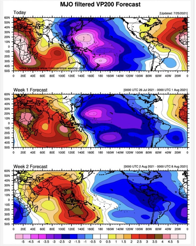
Let’s see how that prediction verifies come November 30, which I think will age like milk. If the tropical Atlantic is so stable, why did we have several MDR invests in June and a (fast-moving) July MDR/Caribbean hurricane? If the Atlantic were really that stable Elsa wouldn’t have formed and the invests wouldn’t have even existed most likely. I can guarantee there will be at least some long trackers in the MDR and Caribbean this year. Everyone suddenly is downcasting as usual just because of a suppressed CCKW moving through which should be gone soon, and then we’ll really see things lighten up in a few weeks.
2 likes
-
Category5Kaiju
- Category 5
- Posts: 4334
- Joined: Thu Dec 24, 2020 12:45 pm
- Location: Seattle and Phoenix
Re: 2021 Indicators: SST's / SAL / MSLP / Shear / Steering / Instability / Sat Images
Wouldn't it also be possible that whatever forms in the tropical Atlantic (assuming it is not very unstable) could get strong by taking advantage of low shear or less dry air and decent ssts but be a small system until it reaches the W Atlantic?
1 likes
Unless explicitly stated, all info in my posts is based on my own opinions and observations. Tropical storms and hurricanes can be extremely dangerous. Refer to an accredited weather research agency or meteorologist if you need to make serious decisions regarding an approaching storm.
-
InfernoFlameCat
- Category 5
- Posts: 2127
- Age: 22
- Joined: Mon Dec 14, 2020 10:52 am
- Location: Buford, GA
Re: 2021 Indicators: SST's / SAL / MSLP / Shear / Steering / Instability / Sat Images
It’s July, of course things are stable. However like Wxman57 said I agree that storms will remain weak in the open Atlantic until they get close or into the GOM or CS.
0 likes
I am by no means a professional. DO NOT look at my forecasts for official information or make decisions based on what I post.
Goal: to become a registered expert over tropical and subtropical cyclones.
Goal: to become a registered expert over tropical and subtropical cyclones.
-
InfernoFlameCat
- Category 5
- Posts: 2127
- Age: 22
- Joined: Mon Dec 14, 2020 10:52 am
- Location: Buford, GA
Re: 2021 Indicators: SST's / SAL / MSLP / Shear / Steering / Instability / Sat Images
Also when Wxman57 does get concerned about a system(Irma for example he picked up on it pretty quick it was a big threat) his instinct is almost dead on. So yeah feeling like this season may resemble major hurricanes like Ike or Ivan(yes it was major in the Atlantic but did not get crazy strong until in the CS) that wait until they get into the GOM or CS before going bonkers.
Also a powerful Ridge in the Atlantic May increase SAL in the Atlantic by pushing that dry air on its south side and flinging it all over the open tropical Atlantic.
Also a powerful Ridge in the Atlantic May increase SAL in the Atlantic by pushing that dry air on its south side and flinging it all over the open tropical Atlantic.
Last edited by InfernoFlameCat on Mon Jul 26, 2021 11:59 am, edited 1 time in total.
0 likes
I am by no means a professional. DO NOT look at my forecasts for official information or make decisions based on what I post.
Goal: to become a registered expert over tropical and subtropical cyclones.
Goal: to become a registered expert over tropical and subtropical cyclones.
-
SFLcane
- S2K Supporter
- Posts: 10281
- Age: 48
- Joined: Sat Jun 05, 2010 1:44 pm
- Location: Lake Worth Florida
Re: 2021 Indicators: SST's / SAL / MSLP / Shear / Steering / Instability / Sat Images
We should start seeing something in the modeling in about 2-3 weeks.
3 likes
Who is online
Users browsing this forum: Hurricane2022, mixedDanilo.E and 306 guests