2021 Indicators: SST's / SAL / MSLP / Shear / Steering / Instability / Sat Images

This is the general tropical discussion area. Anyone can take their shot at predicting a storms path.

Moderator: S2k Moderators

Forum rules

The posts in this forum are NOT official forecasts and should not be used as such. They are just the opinion of the poster and may or may not be backed by sound meteorological data. They are NOT endorsed by any professional institution or STORM2K. For official information, please refer to products from the National Hurricane Center and National Weather Service.

Help Support Storm2K
Message
Author
User avatar
toad strangler
S2K Supporter
S2K Supporter
Posts: 4543
Joined: Sun Jul 28, 2013 3:09 pm
Location: Earth
Contact:

Re: 2021 Indicators: SST's / SAL / MSLP / Shear / Steering / Instability / Sat Images

#1721 Postby toad strangler » Mon Jul 26, 2021 5:31 pm

So there are sound climatological reasons William Gray used to ring the bell every 8/20, NOT 8/1 :D
Rest up!

 http://twitter.com/AndyHazelton/status/1419770450910011394


3 likes   

AlphaToOmega
Category 5
Category 5
Posts: 1448
Joined: Sat Jun 26, 2021 10:51 am
Location: Somewhere in Massachusetts

Re: 2021 Indicators: SST's / SAL / MSLP / Shear / Steering / Instability / Sat Images

#1722 Postby AlphaToOmega » Mon Jul 26, 2021 5:49 pm

toad strangler wrote:So there are sound climatological reasons William Gray used to ring the bell every 8/20, NOT 8/1 :D
Rest up!

http://twitter.com/AndyHazelton/status/1419770450910011394?s=20


Very weak -VP to strong +VP over the EPAC starting August 1 - activity will likely ramp up come August 1
0 likes   

User avatar
Category5Kaiju
Category 5
Category 5
Posts: 4097
Joined: Thu Dec 24, 2020 12:45 pm
Location: Seattle

Re: 2021 Indicators: SST's / SAL / MSLP / Shear / Steering / Instability / Sat Images

#1723 Postby Category5Kaiju » Mon Jul 26, 2021 6:00 pm

It's so interesting to see the two major models with pretty different ideas for what's to come. Although I am not so sure if the idea of favoring the EPAC into peak season is going to be accurate this year due to the simple fact that we're headed toward a more hostile state for the basin.
0 likes   
Unless explicitly stated, all info in my posts is based on my own opinions and observations. Tropical storms and hurricanes can be extremely dangerous. Do not think you can beat Mother Nature. Refer to an accredited weather research agency or meteorologist if you need to make serious decisions regarding an approaching storm.

BYG Jacob

Re: 2021 Indicators: SST's / SAL / MSLP / Shear / Steering / Instability / Sat Images

#1724 Postby BYG Jacob » Mon Jul 26, 2021 6:37 pm

aspen wrote:
BYG Jacob wrote:Based on things right now, it doesn't look like we're gonna get a Maria, Irma, or Isabel. However, just like last year showed, delayed development and a western favored Atlantic is probably the worst-case scenario.

I think Maria formed in a similar position to Elsa, so I definitely won’t exclude the possibility of strong systems forming in the western MDR close to the Caribbean. That’s where Felix originated too. But I will agree that something like Irma — forming in the very easternmost MDR, quickly becoming a hurricane, and spending many days as a major — is probably unlikely now.

The idea of a somewhat favorable ECAR is not something I want to see. Especially if the climate models predicting the late-season favorability in WCAR verify. That means instead of tropical waves moving into the most conducive environment possible, it could be mature hurricanes moving into the most conducive conditions possible.
0 likes   

User avatar
Category5Kaiju
Category 5
Category 5
Posts: 4097
Joined: Thu Dec 24, 2020 12:45 pm
Location: Seattle

Re: 2021 Indicators: SST's / SAL / MSLP / Shear / Steering / Instability / Sat Images

#1725 Postby Category5Kaiju » Mon Jul 26, 2021 6:47 pm

Fyi, I just checked the most recent GFS run, and it shows the EPAC continously spit out cyclones as if we were in a year on the brink of El Nino :cheesy:

I am not quite sure if this is simply the GFS loving the EPAC by nature or if it is actually plausible?
0 likes   
Unless explicitly stated, all info in my posts is based on my own opinions and observations. Tropical storms and hurricanes can be extremely dangerous. Do not think you can beat Mother Nature. Refer to an accredited weather research agency or meteorologist if you need to make serious decisions regarding an approaching storm.

AlphaToOmega
Category 5
Category 5
Posts: 1448
Joined: Sat Jun 26, 2021 10:51 am
Location: Somewhere in Massachusetts

Re: 2021 Indicators: SST's / SAL / MSLP / Shear / Steering / Instability / Sat Images

#1726 Postby AlphaToOmega » Mon Jul 26, 2021 7:10 pm

All signs point to 2021 being a second-year La Nina. Fun fact: second-year La Ninas typically have a similar number of storms as first-year La Ninas, at least as of recent.

1998 (14 storms) -> 1999 (12 storms): 2 storm difference
2007 (15 storms) -> 2008 (16 storms): 1 storm difference
2010 (19 storms) -> 2011 (19 storms): 0 storm difference
2016 (15 storms) -> 2017 (17 storms): 2 storm difference

Based on this, 2021 should have 30 ± 2 storms.
2 likes   

User avatar
Category5Kaiju
Category 5
Category 5
Posts: 4097
Joined: Thu Dec 24, 2020 12:45 pm
Location: Seattle

Re: 2021 Indicators: SST's / SAL / MSLP / Shear / Steering / Instability / Sat Images

#1727 Postby Category5Kaiju » Mon Jul 26, 2021 7:22 pm

AlphaToOmega wrote:All signs point to 2021 being a second-year La Nina. Fun fact: second-year La Ninas typically have a similar number of storms as first-year La Ninas, at least as of recent.

1998 (14 storms) -> 1999 (12 storms): 2 storm difference
2007 (15 storms) -> 2008 (16 storms): 1 storm difference
2010 (19 storms) -> 2011 (19 storms): 0 storm difference
2016 (15 storms) -> 2017 (17 storms): 2 storm difference

Based on this, 2021 should have 30 ± 2 storms.


Not to undermine your point per se, but while we will have to wait and see to know for sure, I simply am not sure if we will get that many NSs this year. That would basically mean we would need to see roughly 6 NSs per ASON (and given what 2005 and 2020 did by now we should be roughly at the H or I storm). I personally think 20 NSs is a good prediction, but if we do manage to get 30 NSs this year, then I am going to have to rethink my understanding of the Atlantic basin as a whole for a while.
1 likes   
Unless explicitly stated, all info in my posts is based on my own opinions and observations. Tropical storms and hurricanes can be extremely dangerous. Do not think you can beat Mother Nature. Refer to an accredited weather research agency or meteorologist if you need to make serious decisions regarding an approaching storm.

User avatar
CyclonicFury
Category 5
Category 5
Posts: 2025
Age: 26
Joined: Sun Jul 02, 2017 12:32 pm
Location: NC
Contact:

Re: 2021 Indicators: SST's / SAL / MSLP / Shear / Steering / Instability / Sat Images

#1728 Postby CyclonicFury » Mon Jul 26, 2021 7:28 pm

AlphaToOmega wrote:All signs point to 2021 being a second-year La Nina. Fun fact: second-year La Ninas typically have a similar number of storms as first-year La Ninas, at least as of recent.

1998 (14 storms) -> 1999 (12 storms): 2 storm difference
2007 (15 storms) -> 2008 (16 storms): 1 storm difference
2010 (19 storms) -> 2011 (19 storms): 0 storm difference
2016 (15 storms) -> 2017 (17 storms): 2 storm difference

Based on this, 2021 should have 30 ± 2 storms.

2020 was a record-breaking season, and had 9 named storms by the end of July. A lot of the alarming indicators in July 2020 (like near record low Atlantic SLP and near record low Caribbean shear) have not been present this year. I don't think 2021 will come anywhere close to 30 named storms. Something around 16-20 seems more likely. We can't expect to repeat 2020's named storm count just because it's a La Niña again.
6 likes   
NCSU B.S. in Meteorology Class of 2021. Tropical weather blogger at http://www.cyclonicfury.com. My forecasts and thoughts are NOT official, for official forecasts please consult the National Hurricane Center.

User avatar
toad strangler
S2K Supporter
S2K Supporter
Posts: 4543
Joined: Sun Jul 28, 2013 3:09 pm
Location: Earth
Contact:

Re: 2021 Indicators: SST's / SAL / MSLP / Shear / Steering / Instability / Sat Images

#1729 Postby toad strangler » Mon Jul 26, 2021 7:44 pm

Always a great reminder ... seek the GREEN dot :ggreen:

Image
12 likes   

User avatar
aspen
Category 5
Category 5
Posts: 8818
Joined: Sat Oct 12, 2019 7:10 pm
Location: Connecticut, USA

Re: 2021 Indicators: SST's / SAL / MSLP / Shear / Steering / Instability / Sat Images

#1730 Postby aspen » Mon Jul 26, 2021 7:44 pm

Category5Kaiju wrote:Fyi, I just checked the most recent GFS run, and it shows the EPAC continously spit out cyclones as if we were in a year on the brink of El Nino :cheesy:

I am not quite sure if this is simply the GFS loving the EPAC by nature or if it is actually plausible?

I think it’s just stuck with the current MJO phase, and we won’t see the models focus onto the Atlantic until the positive MJO has firmly established itself in the basin. Until then, season cancel posts abound.
8 likes   
Irene '11 Sandy '12 Hermine '16 5/15/2018 Derecho Fay '20 Isaias '20 Elsa '21 Henri '21 Ida '21

I am only a meteorology enthusiast who knows a decent amount about tropical cyclones. Look to the professional mets, the NHC, or your local weather office for the best information.

User avatar
DorkyMcDorkface
Category 3
Category 3
Posts: 888
Age: 27
Joined: Mon Sep 30, 2019 1:32 pm
Location: Mid-Atlantic

Re: 2021 Indicators: SST's / SAL / MSLP / Shear / Steering / Instability / Sat Images

#1731 Postby DorkyMcDorkface » Mon Jul 26, 2021 9:17 pm

toad strangler wrote:So there are sound climatological reasons William Gray used to ring the bell every 8/20, NOT 8/1 :D
Rest up!

http://twitter.com/AndyHazelton/status/1419770450910011394?s=20

Image
2 likes   
Please note the thougths expressed by this account are solely those of the user and are from a hobbyist perspective. For more comprehensive analysis, consult an actual professional meteorologist or meteorology agency.


Floyd 1999 | Isabel 2003 | Hanna 2008 | Irene 2011 | Sandy 2012 | Isaias 2020

User avatar
Category5Kaiju
Category 5
Category 5
Posts: 4097
Joined: Thu Dec 24, 2020 12:45 pm
Location: Seattle

Re: 2021 Indicators: SST's / SAL / MSLP / Shear / Steering / Instability / Sat Images

#1732 Postby Category5Kaiju » Mon Jul 26, 2021 9:32 pm

DorkyMcDorkface wrote:
toad strangler wrote:So there are sound climatological reasons William Gray used to ring the bell every 8/20, NOT 8/1 :D
Rest up!

http://twitter.com/AndyHazelton/status/1419770450910011394?s=20

https://cdn.discordapp.com/attachments/733552978572869632/869401639226835046/ezgif-7-0088c13b1b8c.gif


Oh boy, according to that the Atlantic has the green light by mid to end of August...
1 likes   
Unless explicitly stated, all info in my posts is based on my own opinions and observations. Tropical storms and hurricanes can be extremely dangerous. Do not think you can beat Mother Nature. Refer to an accredited weather research agency or meteorologist if you need to make serious decisions regarding an approaching storm.

jaxfladude
Category 5
Category 5
Posts: 1249
Joined: Wed Aug 24, 2005 9:36 pm
Location: Jacksonville, Fla

Re: RE: Re: 2021 Indicators: SST's / SAL / MSLP / Shear / Steering / Instability / Sat Images

#1733 Postby jaxfladude » Tue Jul 27, 2021 3:39 am

Category5Kaiju wrote:
DorkyMcDorkface wrote:
toad strangler wrote:So there are sound climatological reasons William Gray used to ring the bell every 8/20, NOT 8/1 :D
Rest up!

http://twitter.com/AndyHazelton/status/1419770450910011394?s=20

https://cdn.discordapp.com/attachments/733552978572869632/869401639226835046/ezgif-7-0088c13b1b8c.gif


Oh boy, according to that the Atlantic has the green light by mid to end of August...
So, in short, if this verifies, enjoy this current lull period of no designated or named system in the Atlantic Ocean Basin?
0 likes   
Stay safe y'all

jconsor
Professional-Met
Professional-Met
Posts: 551
Joined: Mon Jun 30, 2008 9:31 pm
Location: Jerusalem, Israel
Contact:

Re: 2021 Indicators: SST's / SAL / MSLP / Shear / Steering / Instability / Sat Images

#1734 Postby jconsor » Tue Jul 27, 2021 5:13 am

Apropos to William Gray's famous bell on Aug 20... here is a look at how common hurricanes are in the MDR in the first two-thirds of Aug. The short answer - they are surprisingly uncommon and not a good indicator of seasonal activity!

 https://twitter.com/yconsor/status/1419953725897052162


 https://twitter.com/yconsor/status/1419963017551302657


toad strangler wrote:So there are sound climatological reasons William Gray used to ring the bell every 8/20, NOT 8/1 :D
Rest up!

http://twitter.com/AndyHazelton/status/1419770450910011394?s=20
11 likes   

User avatar
InfernoFlameCat
Category 5
Category 5
Posts: 2102
Age: 22
Joined: Mon Dec 14, 2020 10:52 am
Location: Buford, GA

Re: 2021 Indicators: SST's / SAL / MSLP / Shear / Steering / Instability / Sat Images

#1735 Postby InfernoFlameCat » Tue Jul 27, 2021 6:08 am

AlphaToOmega wrote:All signs point to 2021 being a second-year La Nina. Fun fact: second-year La Ninas typically have a similar number of storms as first-year La Ninas, at least as of recent.

1998 (14 storms) -> 1999 (12 storms): 2 storm difference
2007 (15 storms) -> 2008 (16 storms): 1 storm difference
2010 (19 storms) -> 2011 (19 storms): 0 storm difference
2016 (15 storms) -> 2017 (17 storms): 2 storm difference

Based on this, 2021 should have 30 ± 2 storms.

No
1 likes   
I am by no means a professional. DO NOT look at my forecasts for official information or make decisions based on what I post.

Goal: to become a registered expert over tropical and subtropical cyclones.

User avatar
Category5Kaiju
Category 5
Category 5
Posts: 4097
Joined: Thu Dec 24, 2020 12:45 pm
Location: Seattle

Re: 2021 Indicators: SST's / SAL / MSLP / Shear / Steering / Instability / Sat Images

#1736 Postby Category5Kaiju » Tue Jul 27, 2021 8:35 am

I’m going to be very honest here as I think I fall under the same group at times, but I feel like there are quite a few folks who, after enduring through last year’s 30 named storm season, seem to be conditioned in a way to believe that this season has the potential to do something similar and that getting 30 named storms is very possible. However, I also think it is important to understand that getting that many storms is simply not a common occurrence, and in that sense 2020 was indeed a record breaking season. Hard to believe that simply thinking of getting 19 or 20 named storms now feels like very little, this just shows you how historic of a season 2020 was to make even the fourth or third most active years look puny.
5 likes   
Unless explicitly stated, all info in my posts is based on my own opinions and observations. Tropical storms and hurricanes can be extremely dangerous. Do not think you can beat Mother Nature. Refer to an accredited weather research agency or meteorologist if you need to make serious decisions regarding an approaching storm.

User avatar
SFLcane
S2K Supporter
S2K Supporter
Posts: 10163
Age: 47
Joined: Sat Jun 05, 2010 1:44 pm
Location: Lake Worth Florida

Re: 2021 Indicators: SST's / SAL / MSLP / Shear / Steering / Instability / Sat Images

#1737 Postby SFLcane » Tue Jul 27, 2021 8:49 am

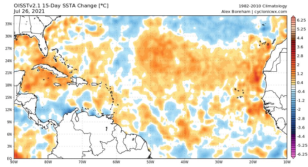
Looks like the Atlantic Nino is waning and warming coming north into MDR.

Image
6 likes   

User avatar
Blown Away
S2K Supporter
S2K Supporter
Posts: 10145
Joined: Wed May 26, 2004 6:17 am

Re: 2021 Indicators: SST's / SAL / MSLP / Shear / Steering / Instability / Sat Images

#1738 Postby Blown Away » Tue Jul 27, 2021 8:53 am

We go through this every year on this board... The GFS will continue to show nothing out 16 days for about a week, maybe tease us with a phantom storm, Storm2k will be "Canceling Season" then @August 10th the GFS will show a Major Cane rolling across the Atlantic days 13-16 with a likely long range hit on Miami or New Orleans before it ultimately recurves OTS... Happens nearly every season... :D
6 likes   
Hurricane Eye Experience: David 79, Irene 99, Frances 04, Jeanne 04, Wilma 05... EYE COMING MY WAY IN 2024…
Hurricane Brush Experience: Andrew 92, Erin 95, Floyd 99, Matthew 16, Irma 17, Ian 22, Nicole 22…

User avatar
Category5Kaiju
Category 5
Category 5
Posts: 4097
Joined: Thu Dec 24, 2020 12:45 pm
Location: Seattle

Re: 2021 Indicators: SST's / SAL / MSLP / Shear / Steering / Instability / Sat Images

#1739 Postby Category5Kaiju » Tue Jul 27, 2021 8:57 am

Blown Away wrote:We go through this every year on this board... The GFS will continue to show nothing out 16 days for about a week, maybe tease us with a phantom storm, Storm2k will be "Canceling Season" then @August 10th the GFS will show a Major Cane rolling across the Atlantic days 13-16 with a likely long range hit on Miami or New Orleans before it ultimately recurves OTS... Happens nearly every season... :D


When it comes down to the Atlantic, while this isn't like true 100% of the time, in quite a few cases, it also feels like when the GFS shows nothing something actually happens, and then when the GFS shows something nothing actually happens (particularly in August).
2 likes   
Unless explicitly stated, all info in my posts is based on my own opinions and observations. Tropical storms and hurricanes can be extremely dangerous. Do not think you can beat Mother Nature. Refer to an accredited weather research agency or meteorologist if you need to make serious decisions regarding an approaching storm.

User avatar
SFLcane
S2K Supporter
S2K Supporter
Posts: 10163
Age: 47
Joined: Sat Jun 05, 2010 1:44 pm
Location: Lake Worth Florida

Re: 2021 Indicators: SST's / SAL / MSLP / Shear / Steering / Instability / Sat Images

#1740 Postby SFLcane » Tue Jul 27, 2021 9:01 am

The Atlantic MDR folks is coming… give it a few more weeks and look out.
3 likes   


Return to “Talkin' Tropics”

Who is online

Users browsing this forum: abajan, AnnularCane, crownweather, duilaslol, ElectricStorm, Sciencerocks and 45 guests