https://twitter.com/AndyHazelton/status/1420006305843056678
https://twitter.com/TheSteveCop/status/1420014826655453201
2021 Indicators: SST's / SAL / MSLP / Shear / Steering / Instability / Sat Images
Moderator: S2k Moderators
Forum rules

The posts in this forum are NOT official forecasts and should not be used as such. They are just the opinion of the poster and may or may not be backed by sound meteorological data. They are NOT endorsed by any professional institution or STORM2K. For official information, please refer to products from the National Hurricane Center and National Weather Service.
-
cycloneye

- Admin

- Posts: 149508
- Age: 69
- Joined: Thu Oct 10, 2002 10:54 am
- Location: San Juan, Puerto Rico
Re: 2021 Indicators: SST's / SAL / MSLP / Shear / Steering / Instability / Sat Images
1 likes
Visit the Caribbean-Central America Weather Thread where you can find at first post web cams,radars
and observations from Caribbean basin members Click Here
and observations from Caribbean basin members Click Here
-
Shell Mound
- Category 5

- Posts: 2432
- Age: 33
- Joined: Thu Sep 07, 2017 3:39 pm
- Location: St. Petersburg, FL → Scandinavia
Re: 2021 Indicators: SST's / SAL / MSLP / Shear / Steering / Instability / Sat Images
https://twitter.com/BenNollWeather/status/1419778997974560782
https://twitter.com/AndyHazelton/status/1419779512510947332
https://twitter.com/dmorris9661/status/1419801839952859143
https://twitter.com/yconsor/status/1419962698121596928
https://twitter.com/dmorris9661/status/1419967825096192001
https://twitter.com/AndyHazelton/status/1419779512510947332
https://twitter.com/dmorris9661/status/1419801839952859143
https://twitter.com/yconsor/status/1419962698121596928
https://twitter.com/dmorris9661/status/1419967825096192001
0 likes
CVW / MiamiensisWx / Shell Mound
The posts in this forum are NOT official forecasts and should not be used as such. They are just the opinion of the poster and may or may not be backed by sound meteorological data. They are NOT endorsed by any professional institution or STORM2K. For official information, please refer to products from the NHC and NWS.

Re: 2021 Indicators: SST's / SAL / MSLP / Shear / Steering / Instability / Sat Images
West CONUS Blocking High continues to be anchored in place.
Rossby Wave unable to create any ARWB.
Series of UL Lows in the MDR.
No foreseeable development in the near term.
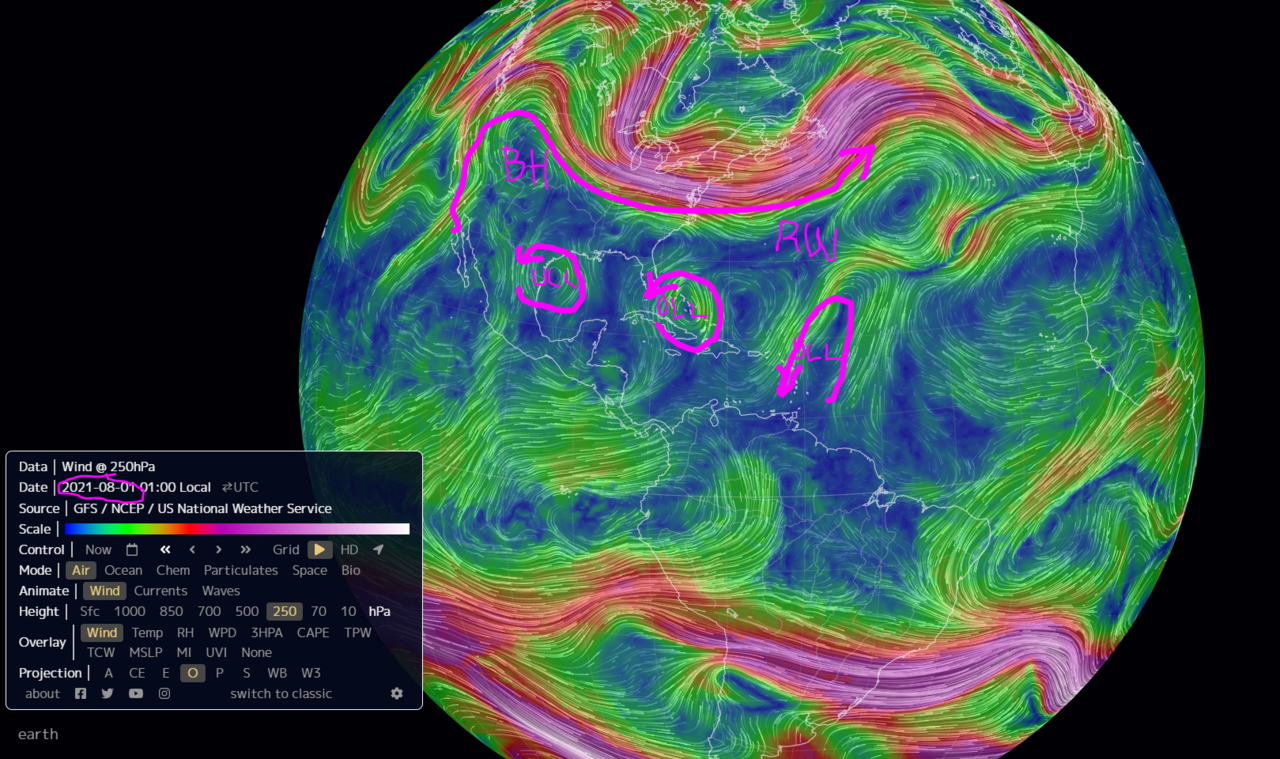
Rossby Wave unable to create any ARWB.
Series of UL Lows in the MDR.
No foreseeable development in the near term.
0 likes
-
SFLcane

- S2K Supporter

- Posts: 10281
- Age: 48
- Joined: Sat Jun 05, 2010 1:44 pm
- Location: Lake Worth Florida
Re: 2021 Indicators: SST's / SAL / MSLP / Shear / Steering / Instability / Sat Images
GCANE wrote:West CONUS Blocking High continues to be anchored in place.
Rossby Wave unable to create any ARWB.
Series of UL Lows in the MDR.
No foreseeable development in the near term.
[url]https://i.postimg.cc/TY2G3Ls4/RW1.png [/url]
That’s all about to change.
4 likes

Re: 2021 Indicators: SST's / SAL / MSLP / Shear / Steering / Instability / Sat Images
Say goodbye to SST handwringing!
https://cyclonicwx.com/sst/
The MDR is rapidly filling up with warm SST anomalies and is the closest to average it has been in months, while the Gulf has risen to +0.51C above average. The -AMO look of the last few weeks has been replaced with an almost evenly average to warmer-than-average look for the basin.
9 likes
Irene '11 Sandy '12 Hermine '16 5/15/2018 Derecho Fay '20 Isaias '20 Elsa '21 Henri '21 Ida '21
I am only a meteorology enthusiast who knows a decent amount about tropical cyclones. Look to the professional mets, the NHC, or your local weather office for the best information.
I am only a meteorology enthusiast who knows a decent amount about tropical cyclones. Look to the professional mets, the NHC, or your local weather office for the best information.
-
Category5Kaiju

- Category 5
- Posts: 4334
- Joined: Thu Dec 24, 2020 12:45 pm
- Location: Seattle and Phoenix
Re: 2021 Indicators: SST's / SAL / MSLP / Shear / Steering / Instability / Sat Images
aspen wrote:Say goodbye to SST handwringing!
https://cyclonicwx.com/sst/
The MDR is rapidly filling up with warm SST anomalies and is the closest to average it has been in months, while the Gulf has risen to +0.51C above average. The -AMO look of the last few weeks has been replaced with an almost evenly average to warmer-than-average look for the basin.
As expected. I certainly had my doubts earlier this year like in May or June about the talks of the Atlantic never being able to warm up by peak season and making the season inactive as a result.
2 likes
Unless explicitly stated, all info in my posts is based on my own opinions and observations. Tropical storms and hurricanes can be extremely dangerous. Refer to an accredited weather research agency or meteorologist if you need to make serious decisions regarding an approaching storm.
-
IsabelaWeather
- Category 1

- Posts: 316
- Age: 36
- Joined: Tue Jul 07, 2020 7:29 am
- Location: Isabela, Puerto Rico
Re: 2021 Indicators: SST's / SAL / MSLP / Shear / Steering / Instability / Sat Images
whats with the little swirl of vorticity just to the NE of Puerto Rico? Been watching it ll day, too bad its not headed for the island, would be cool to watch.
https://www.star.nesdis.noaa.gov/GOES/sector_band.php?sat=G16§or=pr&band=GEOCOLOR&length=12
https://www.star.nesdis.noaa.gov/GOES/sector_band.php?sat=G16§or=pr&band=GEOCOLOR&length=12
3 likes
-
cycloneye
- Admin
- Posts: 149508
- Age: 69
- Joined: Thu Oct 10, 2002 10:54 am
- Location: San Juan, Puerto Rico
Re: 2021 Indicators: SST's / SAL / MSLP / Shear / Steering / Instability / Sat Images
https://twitter.com/AndyHazelton/status/1420087940823359488
https://twitter.com/WxTca/status/1420027088862654464
https://twitter.com/WxTca/status/1420027088862654464
1 likes
Visit the Caribbean-Central America Weather Thread where you can find at first post web cams,radars
and observations from Caribbean basin members Click Here
and observations from Caribbean basin members Click Here
-
AlphaToOmega
- Category 5
- Posts: 1448
- Joined: Sat Jun 26, 2021 10:51 am
- Location: Somewhere in Massachusetts
Re: 2021 Indicators: SST's / SAL / MSLP / Shear / Steering / Instability / Sat Images
The suppressed MJO phase started around July 5. Suppressed and active MJO phases each last around 30-40 days. Therefore, activity should start ramping up come August 4-14.
2 likes
-
Category5Kaiju
- Category 5
- Posts: 4334
- Joined: Thu Dec 24, 2020 12:45 pm
- Location: Seattle and Phoenix
Re: 2021 Indicators: SST's / SAL / MSLP / Shear / Steering / Instability / Sat Images
Also keep in mind homegrown activity could ramp up slightly earlier than MDR/open Atlantic activity. Some recent examples of this occurring include 2017 and 2020 interestingly.
6 likes
Unless explicitly stated, all info in my posts is based on my own opinions and observations. Tropical storms and hurricanes can be extremely dangerous. Refer to an accredited weather research agency or meteorologist if you need to make serious decisions regarding an approaching storm.
-
captainbarbossa19

- Professional-Met

- Posts: 1094
- Age: 27
- Joined: Wed Aug 21, 2019 11:09 pm
- Location: Beaumont, TX
Re: 2021 Indicators: SST's / SAL / MSLP / Shear / Steering / Instability / Sat Images
Category5Kaiju wrote:Blown Away wrote:We go through this every year on this board... The GFS will continue to show nothing out 16 days for about a week, maybe tease us with a phantom storm, Storm2k will be "Canceling Season" then @August 10th the GFS will show a Major Cane rolling across the Atlantic days 13-16 with a likely long range hit on Miami or New Orleans before it ultimately recurves OTS... Happens nearly every season...
When it comes down to the Atlantic, while this isn't like true 100% of the time, in quite a few cases, it also feels like when the GFS shows nothing something actually happens, and then when the GFS shows something nothing actually happens (particularly in August).
Right. Most of the time, the storms that scare me the most are the ones that struggle and the models want to kill, but they keep fighting the odds. Then, when they find favorable conditions, they explode into strong hurricanes. Also, I find it interesting how often models underestimate the strength of ridges. It seems like over the past few years, many storms that were originally predicted to go OTS, instead get blocked by a stronger ridge.
0 likes
Re: 2021 Indicators: SST's / SAL / MSLP / Shear / Steering / Instability / Sat Images
If you take the mean between the OISST and CRW SSTs, the MDR is slightly warmer than average (+0.092C). Both maps show a clear warming trend and a more even distribution of +SST anomalies across the Gulf (which is over half a degree warmer than normal), Caribbean, MDR, and subtropics. It's safe to say that, unless we see a massive burst of SAL or some cooling trade winds, Atlantic SSTs will be in a good setup for peak season. Thankfully not as crazy looking as 2004, 2005, 2017, and 2020, but still able to support high levels of activity.


5 likes
Irene '11 Sandy '12 Hermine '16 5/15/2018 Derecho Fay '20 Isaias '20 Elsa '21 Henri '21 Ida '21
I am only a meteorology enthusiast who knows a decent amount about tropical cyclones. Look to the professional mets, the NHC, or your local weather office for the best information.
I am only a meteorology enthusiast who knows a decent amount about tropical cyclones. Look to the professional mets, the NHC, or your local weather office for the best information.
-
SFLcane
- S2K Supporter
- Posts: 10281
- Age: 48
- Joined: Sat Jun 05, 2010 1:44 pm
- Location: Lake Worth Florida
Re: 2021 Indicators: SST's / SAL / MSLP / Shear / Steering / Instability / Sat Images
Holy cow now that some serious warming! 

3 likes
-
Category5Kaiju
- Category 5
- Posts: 4334
- Joined: Thu Dec 24, 2020 12:45 pm
- Location: Seattle and Phoenix
Re: 2021 Indicators: SST's / SAL / MSLP / Shear / Steering / Instability / Sat Images
To sum it all up:
Quite a few Atlantic hurricane trackers: "The MDR is cool! It is going to be very hard to get an above average season!"
Atlantic MDR: "HEY! I heard that. You insult me, I'm going to show you otherwise! "
"
Quite a few Atlantic hurricane trackers: "The MDR is cool! It is going to be very hard to get an above average season!"
Atlantic MDR: "HEY! I heard that. You insult me, I'm going to show you otherwise!
6 likes
Unless explicitly stated, all info in my posts is based on my own opinions and observations. Tropical storms and hurricanes can be extremely dangerous. Refer to an accredited weather research agency or meteorologist if you need to make serious decisions regarding an approaching storm.
-
Kingarabian

- S2K Supporter
- Posts: 16366
- Joined: Sat Aug 08, 2009 3:06 am
- Location: Honolulu, Hawaii
Re: 2021 Indicators: SST's / SAL / MSLP / Shear / Steering / Instability / Sat Images
Once the EPAC shuts down it should be all systems go for the Atlantic.
7 likes
RIP Kobe Bryant
-
AxaltaRacing24
- Category 5
- Posts: 1774
- Age: 25
- Joined: Wed Jul 27, 2016 11:14 am
- Location: Jupiter, FL
Re: 2021 Indicators: SST's / SAL / MSLP / Shear / Steering / Instability / Sat Images
Freezing out there isn't it?
1 likes
-
AtlanticWind

- S2K Supporter
- Posts: 1898
- Age: 67
- Joined: Sun Aug 08, 2004 9:57 pm
- Location: Plantation,Fla
Re: 2021 Indicators: SST's / SAL / MSLP / Shear / Steering / Instability / Sat Images
With the MDR warming , I would be shocked if this is not an extremely active season. ( also pleased if the season busted , as much as I enjoy tracking I have seen the destruction they cause).
Everything is in place , Warming atlantic / La nina or close to one / Healthy wave train.
Its just a matter of when things pop. My guess is August 10th to 20th
Even if it is a later start , I think once things get going its going to be quite a burst for 8 to 10 weeks.
Just my amateur opinion. Hope I'm wrong.......
0 likes
-
Shell Mound
- Category 5
- Posts: 2432
- Age: 33
- Joined: Thu Sep 07, 2017 3:39 pm
- Location: St. Petersburg, FL → Scandinavia
Re: 2021 Indicators: SST's / SAL / MSLP / Shear / Steering / Instability / Sat Images
AxaltaRacing24 wrote:
Freezing out there isn't it?
Personally I think the warming over the past four to five days is temporary. The long-term trend on the charts is negligible. One must look at the moving average for the entire period in question rather than short-term trends. Wait another week and a half and the warming will reverse, that is, revert to the long-term moving average. So far every short-term warming trend has reversed itself after a while. I doubt that this latest trend will be different from the rest, but we shall see. The Canary Current remains cool and all the TC activity in the CPAC is atypical of a -PMM/-ENSO combination.
0 likes
CVW / MiamiensisWx / Shell Mound
The posts in this forum are NOT official forecasts and should not be used as such. They are just the opinion of the poster and may or may not be backed by sound meteorological data. They are NOT endorsed by any professional institution or STORM2K. For official information, please refer to products from the NHC and NWS.
-
AxaltaRacing24
- Category 5
- Posts: 1774
- Age: 25
- Joined: Wed Jul 27, 2016 11:14 am
- Location: Jupiter, FL
Re: 2021 Indicators: SST's / SAL / MSLP / Shear / Steering / Instability / Sat Images
Shell Mound wrote:AxaltaRacing24 wrote:
Freezing out there isn't it?
Personally I think the warming over the past four to five days is temporary. The long-term trend on the charts is negligible. One must look at the moving average for the entire period in question rather than short-term trends. Wait another week and a half and the warming will reverse, that is, revert to the long-term moving average. So far every short-term warming trend has reversed itself after a while. I doubt that this latest trend will be different from the rest, but we shall see. The Canary Current remains cool and all the TC activity in the CPAC is atypical of a -PMM/-ENSO combination.
Literally every model has warming until peak season. I doubt we will see any more serious cooling. This is not just a 15 day trend either. Look at posts in this thread in June, and compare those images to today......
7 likes
-
AtlanticWind
- S2K Supporter
- Posts: 1898
- Age: 67
- Joined: Sun Aug 08, 2004 9:57 pm
- Location: Plantation,Fla
Re: 2021 Indicators: SST's / SAL / MSLP / Shear / Steering / Instability / Sat Images
Shell Mound wrote:AxaltaRacing24 wrote:
Freezing out there isn't it?
Personally I think the warming over the past four to five days is temporary. The long-term trend on the charts is negligible. One must look at the moving average for the entire period in question rather than short-term trends. Wait another week and a half and the warming will reverse, that is, revert to the long-term moving average. So far every short-term warming trend has reversed itself after a while. I doubt that this latest trend will be different from the rest, but we shall see. The Canary Current remains cool and all the TC activity in the CPAC is atypical of a -PMM/-ENSO combination.
I have not followed the CPAC closely but I didnt think anything was going on there.
As for the warming I think this was expected and maybe a little late, but my bet is we will have above average temps
in the MDR thru the heart of the season.
1 likes
Who is online
Users browsing this forum: Ulf and 142 guests