The posts in this forum are NOT official forecasts and should not be used as such. They are just the opinion of the poster and may or may not be backed by sound meteorological data. They are NOT endorsed by any professional institution or STORM2K. For official information, please refer to products from the National Hurricane Center and National Weather Service.
aspen wrote:Looks like the CRW SST graphs on cyclonicwx have been corrected. It’s now saying that the MDR is +0.25C warmer than average, which matches up a lot more with the CRW map than the +0.092C estimate from last night. The entire graph seems to have been moved up.
Yes, turns out I had forgotten to switch over climos to the graphs when I used a new one last year.
Definitely looks more consistent with the maps now.
6 likes
This post was probably an opinion of mine, and in no way is official. Please refer to http://www.hurricanes.gov for official tropical analysis and advisories.
My website, with lots of tropical wx graphics, including satellite and recon: http://cyclonicwx.com
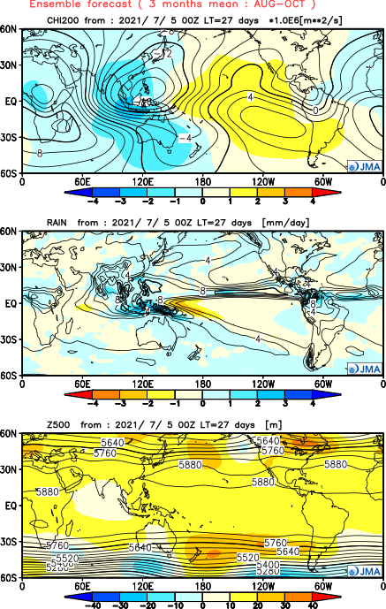
In regards to Andy Hazelton's twitter post if this is Atlantic El Nino induced, it's too early to definitively pinpoint exactly what type of Atlantic El Nino mode we're in, but we can start to get a general idea (for reference, here is my post on the different Atlantic El Nino modes - viewtopic.php?p=2915989#p2915989). Based on seasonal DJF (December-February) and MAM (March-May), we can rule out late onset. Current analysis still shows a vigorous Atlantic Nino, so we can also rule out early termination (this would have began in MAM). That leaves persistent and early onset. This closely matches the current SSTA configuration:
The ECMWF monsoonal projection, while a bit north, would also be something we would typically see for July-August:
USTropics wrote:In regards to Andy Hazelton's twitter post if this is Atlantic El Nino induced, it's too early to definitively pinpoint exactly what type of Atlantic El Nino mode we're in, but we can start to get a general idea (for reference, here is my post on the different Atlantic El Nino modes - viewtopic.php?p=2915989#p2915989). Based on seasonal DJF (December-February) and MAM (March-May), we can rule out late onset. Current analysis still shows a vigorous Atlantic Nino, so we can also rule out early termination (this would have began in MAM). That leaves persistent and early onset. This closely matches the current SSTA configuration:
The ECMWF monsoonal projection, while a bit north, would also be something we would typically see for July-August: https://i.imgur.com/ZQWLCzJ.png
1988, 1995, 1998, and 2010 definitely ring bells. All four of those years featured at least one very strong, long-lived MDR-born tracker. I think at least based on this alone the idea that the MDR will definitely be closed for business during peak season this year is quite questionable.
2 likes
Unless explicitly stated, all info in my posts is based on my own opinions and observations. Tropical storms and hurricanes can be extremely dangerous. Refer to an accredited weather research agency or meteorologist if you need to make serious decisions regarding an approaching storm.
Would such a vigorous trough help or hamper TC genesis? It’ll certainly give waves a lot of moisture to work with and they’ll still be at a low latitude, but could it result in very broad waves that take forever to consolidate like the precursors to Isaias and Laura?
I am only a meteorology enthusiast who knows a decent amount about tropical cyclones. Look to the professional mets, the NHC, or your local weather office for the best information.
Interesting recent GFS run shows what looks to be a closed off low but small system that treks across the MDR before dying near the Antilles by the time of August 7-11. Then again, it is showing the EPAC shooting out storm after storm like a machine gun, so yeah. Not sure if that is really realistic, especially on the EPAC side.
4 likes
Unless explicitly stated, all info in my posts is based on my own opinions and observations. Tropical storms and hurricanes can be extremely dangerous. Refer to an accredited weather research agency or meteorologist if you need to make serious decisions regarding an approaching storm.
aspen wrote:Would such a vigorous trough help or hamper TC genesis? It’ll certainly give waves a lot of moisture to work with and they’ll still be at a low latitude, but could it result in very broad waves that take forever to consolidate like the precursors to Isaias and Laura?
Waves in the MDR that take long to consolidate and then get their act together as they approach 50W or thereabouts are disconcerting. So, I'm hoping conditions between 20W and 50W become super favorable for cyclogenesis during the active portion of the season, since (as a rule of thumb) strong systems travel more WNW than W. Not relishing prospects of another Barbados hit this year. Cat1 was plenty strong enough for me.
That might put regions further north at risk if the ridging is as strong as models say it’ll be, and it prevents an east-forming system from gaining a ton of latitude or recurving harmlessly into the open Atlantic. But we’ll have to wait and see.
Last year, we had a bunch of trees cleared out and got a portable generator, so we should be good for the next significant TC impact (I’m up in Connecticut but still keep a close eye regardless). Would that strong ridging prevent storms from reaching the mid-Atlantic and New England region?
I am only a meteorology enthusiast who knows a decent amount about tropical cyclones. Look to the professional mets, the NHC, or your local weather office for the best information.
aspen wrote:Would such a vigorous trough help or hamper TC genesis? It’ll certainly give waves a lot of moisture to work with and they’ll still be at a low latitude, but could it result in very broad waves that take forever to consolidate like the precursors to Isaias and Laura?
Waves in the MDR that take long to consolidate and then get their act together as they approach 50W or thereabouts are disconcerting. So, I'm hoping conditions between 20W and 50W become super favorable for cyclogenesis during the active portion of the season, since (as a rule of thumb) strong systems travel more WNW than W. Not relishing prospects of another Barbados hit this year. Cat1 was plenty strong enough for me.
That might put regions further north at risk if the ridging is as strong as models say it’ll be, and it prevents an east-forming system from gaining a ton of latitude or recurving harmlessly into the open Atlantic. But we’ll have to wait and see.
Last year, we had a bunch of trees cleared out and got a portable generator, so we should be good for the next significant TC impact (I’m up in Connecticut but still keep a close eye regardless). Would that strong ridging prevent storms from reaching the mid-Atlantic and New England region?
Of course not, it takes westward based ridging to get a storm into the NE ... the return rate of a significant tropical system in for your area is rather long not matter what Joe Bastardi says, however, it only takes one!
The juice Is moving in. I was sort of thinking we had a September and a bunch of October for the 2021 season. But we might get a couple second half of August systems. This is a pretty strong pulse of favorability which may only serve to clear the path or set the proverbial table for the next Kelvin wave if it coincides with an MJO pulse into the favorable phases. You don’t always see this strong of a signal in July. http://mikeventrice.weebly.com/mjo.html
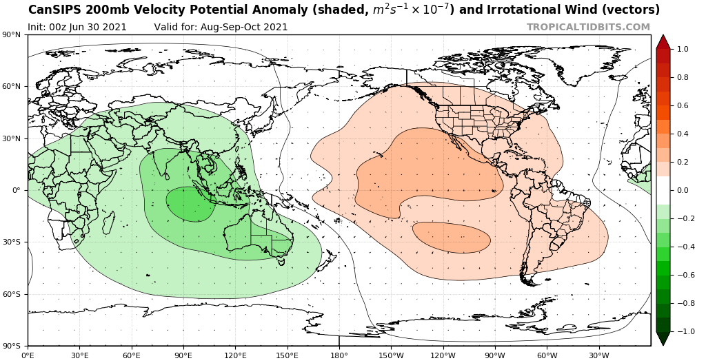
This pattern is virtually identical to last year’s and also contributed to an underwhelming season in the MDR, as most AEWs were too broad and disorganised for most of their trek westward across the MDR, prior to reaching the Lesser Antilles. Currently the C/EPAC look to generate at least two major hurricanes within the next few weeks, along with two or more additional systems. As long as the C/EPAC continue to behave as though we were in +PMM/+PDO/+ENSO the active African monsoon could actually prevent a more active Atlantic season, as systems that would initially struggle to consolidate would then encounter strong VWS over the Caribbean, thanks to the active C/EPAC convection. Sprawling waves that take time to consolidate over the MDR would end up facing shear over the western part of the Atlantic basin. So I disagree with people who say that an active MDR would be better for the islands and other land-masses, given that the MDR tends to produce the majority of upper-end MH landfalls. Currently I am still rather bearish about the prospects of this season, given the fact that the CFSv2 seems to be handling the amplitude and progression of the MJO better than the EPS, while the Atlantic still retains a persistently residual -AMM/-AMO (look at the coolish Canary Current and its refusal to warm up).
A very telling comparison: the WPAC-style monsoonal trough in the Atlantic does practically nothing, while the EPAC monsoon generates multiple hurricanes:
All in all, the indicators suggest that the rising cell over the C/EPAC is going to be more persistent and stronger than many people might expect.
0 likes
CVW / MiamiensisWx / Shell Mound
The posts in this forum are NOT official forecasts and should not be used as such. They are just the opinion of the poster and may or may not be backed by sound meteorological data. They are NOT endorsed by any professional institution or STORM2K. For official information, please refer to products from the NHC and NWS.
This pattern is virtually identical to last year’s and also contributed to an underwhelming season in the MDR, as most AEWs were too broad and disorganised for most of their trek westward across the MDR, prior to reaching the Lesser Antilles. Currently the C/EPAC look to generate at least two major hurricanes within the next few weeks, along with two or more additional systems. As long as the C/EPAC continue to behave as though we were in +PMM/+PDO/+ENSO the active African monsoon could actually prevent a more active Atlantic season, as systems that would initially struggle to consolidate would then encounter strong VWS over the Caribbean, thanks to the active C/EPAC convection. Sprawling waves that take time to consolidate over the MDR would end up facing shear over the western part of the Atlantic basin. So I disagree with people who say that an active MDR would be better for the islands and other land-masses, given that the MDR tends to produce the majority of upper-end MH landfalls. Currently I am still rather bearish about the prospects of this season, given the fact that the CFSv2 seems to be handling the amplitude and progression of the MJO better than the EPS, while the Atlantic still retains a persistently residual -AMM/-AMO (look at the coolish Canary Current and its refusal to warm up).
A very telling comparison: the WPAC-style monsoonal trough in the Atlantic does practically nothing, while the EPAC monsoon generates multiple hurricanes:
All in all, the indicators suggest that the rising cell over the C/EPAC is going to be more persistent and stronger than many people might expect.
The GFS depicted the same thing with Guillermo and that failed invest and we know how that turned out. Not buying into the GFS’s EPac major spam. In addition CFS tends to be biased towards pseudo +ENSO conditions (which it predicted last year for September which verified poorly and didn’t materialize). Also it tends to have a bias towards the EPac and keeping the rising cell/MJO in the EPac or w/e which causes ghost storms or overdoing the intensity of storms in the EPac. The monsoon trough setup could easily fix itself by late August and still contribute to a decent MDR season. Finally, the -AMO look is complete crap as from what I can see I do not see any sort of indication that’s the case, and in fact the MDR has been warming decently in the past few days, erasing any sort of “-AMO look”. I have a feeling come November 30, some or a good portion of those talking points of yours are gonna age badly, no offense.
Last edited by MarioProtVI on Thu Jul 29, 2021 6:26 am, edited 1 time in total.