2021 Global Model Runs Discussion (Out thru day 16)

This is the general tropical discussion area. Anyone can take their shot at predicting a storms path.

Moderator: S2k Moderators

Forum rules

The posts in this forum are NOT official forecasts and should not be used as such. They are just the opinion of the poster and may or may not be backed by sound meteorological data. They are NOT endorsed by any professional institution or STORM2K. For official information, please refer to products from the National Hurricane Center and National Weather Service.

Help Support Storm2K
Message
Author
User avatar
captainbarbossa19
Professional-Met
Professional-Met
Posts: 1092
Age: 27
Joined: Wed Aug 21, 2019 11:09 pm
Location: Beaumont, TX

Re: 2021 Global Model Runs Discussion (Out thru day 16)

#381 Postby captainbarbossa19 » Thu Jul 29, 2021 1:04 pm

SFLcane wrote:
abajan wrote:
cycloneye wrote:GFS is more bullish at 18z.

https://i.imgur.com/D4WnroH.gif

And it's still there on the 6z run.
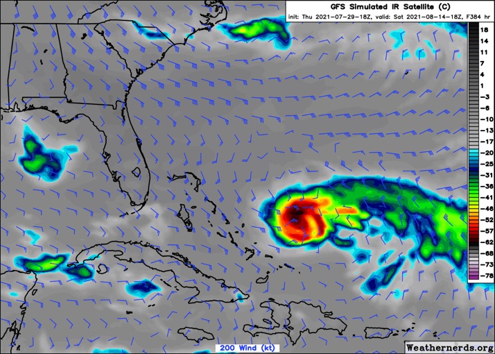
For now, it appears it will miss the Antilles, and weaken as it does so.

https://i.imgur.com/j4G4OLh.gif


No concern for the islands there is a giant TUTT protecting the CONUS.


Somehow, I feel like things are going to be totally different on or after August 20th.
0 likes   

User avatar
beoumont
Category 1
Category 1
Posts: 473
Joined: Sun Jul 10, 2011 4:13 pm
Location: East Central Florida
Contact:

Re: 2021 Global Model Runs Discussion (Out thru day 16)

#382 Postby beoumont » Thu Jul 29, 2021 1:18 pm

SFLcane wrote:
My friend, have some patience only a matter of time before the gfs show the first cat 4-5 heading for SFL lol. I was actually thinking if creating a poll or thread for it as we wait for activity to pick up. In all seriousness ramp you should commence around Aug 15-20 or bit after. :wink:


Might have to wait 'till the next full moon: August 22.

Image
0 likes   
List of 79 tropical cyclones intercepted by Richard Horodner:
http://www.canebeard.com/page/page/572246.htm

User avatar
cycloneye
Admin
Admin
Posts: 145308
Age: 68
Joined: Thu Oct 10, 2002 10:54 am
Location: San Juan, Puerto Rico

Re: 2021 Global Model Runs Discussion (Out thru day 16)

#383 Postby cycloneye » Thu Jul 29, 2021 2:01 pm

12z Euro.

Image
3 likes   
Visit the Caribbean-Central America Weather Thread where you can find at first post web cams,radars
and observations from Caribbean basin members Click Here

User avatar
Stormybajan
Category 1
Category 1
Posts: 448
Joined: Thu May 20, 2021 3:21 pm
Location: Windward Islands

Re: 2021 Global Model Runs Discussion (Out thru day 16)

#384 Postby Stormybajan » Thu Jul 29, 2021 2:03 pm

cycloneye wrote:12z Euro.

https://i.imgur.com/H6yWa4s.gif


No development but two strong tropical waves...I like it :) its hot out here the windwards could use the rain
3 likes   
Sad West Indies and Manchester United fan ⚽️

User avatar
toad strangler
S2K Supporter
S2K Supporter
Posts: 4543
Joined: Sun Jul 28, 2013 3:09 pm
Location: Earth
Contact:

Re: 2021 Global Model Runs Discussion (Out thru day 16)

#385 Postby toad strangler » Thu Jul 29, 2021 3:01 pm

Two TW's in Euro long range? Uh Oh …..
0 likes   

User avatar
Category5Kaiju
Category 5
Category 5
Posts: 4097
Joined: Thu Dec 24, 2020 12:45 pm
Location: Seattle

Re: 2021 Global Model Runs Discussion (Out thru day 16)

#386 Postby Category5Kaiju » Thu Jul 29, 2021 3:08 pm

toad strangler wrote:Two TW's in Euro long range? Uh Oh …..


All Hail King Euro!!! :D
0 likes   
Unless explicitly stated, all info in my posts is based on my own opinions and observations. Tropical storms and hurricanes can be extremely dangerous. Do not think you can beat Mother Nature. Refer to an accredited weather research agency or meteorologist if you need to make serious decisions regarding an approaching storm.

User avatar
captainbarbossa19
Professional-Met
Professional-Met
Posts: 1092
Age: 27
Joined: Wed Aug 21, 2019 11:09 pm
Location: Beaumont, TX

Re: 2021 Global Model Runs Discussion (Out thru day 16)

#387 Postby captainbarbossa19 » Thu Jul 29, 2021 4:26 pm

Stormybajan wrote:
cycloneye wrote:12z Euro.

https://i.imgur.com/H6yWa4s.gif


No development but two strong tropical waves...I like it :) its hot out here the windwards could use the rain


I will not be surprised if the models drop development about five days before something forms and then they form anyway.
0 likes   

User avatar
Category5Kaiju
Category 5
Category 5
Posts: 4097
Joined: Thu Dec 24, 2020 12:45 pm
Location: Seattle

Re: 2021 Global Model Runs Discussion (Out thru day 16)

#388 Postby Category5Kaiju » Thu Jul 29, 2021 4:32 pm

captainbarbossa19 wrote:
Stormybajan wrote:
cycloneye wrote:12z Euro.

https://i.imgur.com/H6yWa4s.gif


No development but two strong tropical waves...I like it :) its hot out here the windwards could use the rain


I will not be surprised if the models drop development about five days before something forms and then they form anyway.


GFS is notorious for this. It’s basically like the letter V, first it is super excited, then as time gets closer it completely drops formation, and then once time is very close the GFS will show the system again.
3 likes   
Unless explicitly stated, all info in my posts is based on my own opinions and observations. Tropical storms and hurricanes can be extremely dangerous. Do not think you can beat Mother Nature. Refer to an accredited weather research agency or meteorologist if you need to make serious decisions regarding an approaching storm.

User avatar
Category5Kaiju
Category 5
Category 5
Posts: 4097
Joined: Thu Dec 24, 2020 12:45 pm
Location: Seattle

Re: 2021 Global Model Runs Discussion (Out thru day 16)

#389 Postby Category5Kaiju » Thu Jul 29, 2021 5:51 pm

Category5Kaiju wrote:
captainbarbossa19 wrote:
Stormybajan wrote:
No development but two strong tropical waves...I like it :) its hot out here the windwards could use the rain


I will not be surprised if the models drop development about five days before something forms and then they form anyway.


GFS is notorious for this. It’s basically like the letter V, first it is super excited, then as time gets closer it completely drops formation, and then once time is very close the GFS will show the system again.


Edit: 18z GFS so far shows the system again in the MDR by the August 8/9 timeframe
1 likes   
Unless explicitly stated, all info in my posts is based on my own opinions and observations. Tropical storms and hurricanes can be extremely dangerous. Do not think you can beat Mother Nature. Refer to an accredited weather research agency or meteorologist if you need to make serious decisions regarding an approaching storm.

User avatar
aspen
Category 5
Category 5
Posts: 8818
Joined: Sat Oct 12, 2019 7:10 pm
Location: Connecticut, USA

Re: 2021 Global Model Runs Discussion (Out thru day 16)

#390 Postby aspen » Thu Jul 29, 2021 5:55 pm

Category5Kaiju wrote:
captainbarbossa19 wrote:
I will not be surprised if the models drop development about five days before something forms and then they form anyway.


GFS is notorious for this. It’s basically like the letter V, first it is super excited, then as time gets closer it completely drops formation, and then once time is very close the GFS will show the system again.


Edit: 18z GFS so far shows the system again in the MDR by the August 8/9 timeframe

The GFS has only showed this system in the 06z and 18z runs; it always disappears in the 00z and 12z runs.
1 likes   
Irene '11 Sandy '12 Hermine '16 5/15/2018 Derecho Fay '20 Isaias '20 Elsa '21 Henri '21 Ida '21

I am only a meteorology enthusiast who knows a decent amount about tropical cyclones. Look to the professional mets, the NHC, or your local weather office for the best information.

User avatar
cycloneye
Admin
Admin
Posts: 145308
Age: 68
Joined: Thu Oct 10, 2002 10:54 am
Location: San Juan, Puerto Rico

Re: 2021 Global Model Runs Discussion (Out thru day 16)

#391 Postby cycloneye » Thu Jul 29, 2021 5:57 pm

18z GFS has the strongest run yet.

Image
2 likes   
Visit the Caribbean-Central America Weather Thread where you can find at first post web cams,radars
and observations from Caribbean basin members Click Here

User avatar
AtlanticWind
S2K Supporter
S2K Supporter
Posts: 1888
Age: 66
Joined: Sun Aug 08, 2004 9:57 pm
Location: Plantation,Fla

Re: 2021 Global Model Runs Discussion (Out thru day 16)

#392 Postby AtlanticWind » Thu Jul 29, 2021 6:05 pm

cycloneye wrote:18z GFS has the strongest run yet.

https://i.imgur.com/HcD0iSM.gif

Could be the first signal of the begining of the active phase of the season.
0 likes   

User avatar
toad strangler
S2K Supporter
S2K Supporter
Posts: 4543
Joined: Sun Jul 28, 2013 3:09 pm
Location: Earth
Contact:

Re: 2021 Global Model Runs Discussion (Out thru day 16)

#393 Postby toad strangler » Thu Jul 29, 2021 6:12 pm

Happy Hour 18z GFS gonna Happy Hour :37:
1 likes   

User avatar
SFLcane
S2K Supporter
S2K Supporter
Posts: 10163
Age: 47
Joined: Sat Jun 05, 2010 1:44 pm
Location: Lake Worth Florida

Re: 2021 Global Model Runs Discussion (Out thru day 16)

#394 Postby SFLcane » Thu Jul 29, 2021 6:38 pm

toad strangler wrote:Happy Hour 18z GFS gonna Happy Hour :37:


Sorta reminds me of an A storm glad it’s fantasy land. You can see the dual outflow channels and it gets even better surrounded by 9 knots of shear with BIG ridge overhead. If tc tracks anything like this during ASO we in trouble.

Image

Image
2 likes   

User avatar
Category5Kaiju
Category 5
Category 5
Posts: 4097
Joined: Thu Dec 24, 2020 12:45 pm
Location: Seattle

Re: 2021 Global Model Runs Discussion (Out thru day 16)

#395 Postby Category5Kaiju » Thu Jul 29, 2021 6:40 pm

SFLcane wrote:
toad strangler wrote:Happy Hour 18z GFS gonna Happy Hour :37:


Sorta reminds me of an A storm glad it’s fantasy land. You can see the dual outflow channels and it gets even better surrounded by 9 knots of shear with BIG ridge overhead. If tc tracks anything like this we in trouble.

https://i.postimg.cc/jqQn1SQD/69-D27-C29-C824-45-C1-9-FE6-31-DF04-A6-A633.jpg

https://i.postimg.cc/02kK11cc/5-F95-EBD2-B578-41-C9-9-D8-B-548-EB4-BD14-DB.jpg


Or a D storm...didn't hit Florida, but it sure became a huge scare
0 likes   
Unless explicitly stated, all info in my posts is based on my own opinions and observations. Tropical storms and hurricanes can be extremely dangerous. Do not think you can beat Mother Nature. Refer to an accredited weather research agency or meteorologist if you need to make serious decisions regarding an approaching storm.

User avatar
abajan
S2K Supporter
S2K Supporter
Posts: 4230
Joined: Sun Sep 07, 2003 5:10 am
Location: Barbados

Re: 2021 Global Model Runs Discussion (Out thru day 16)

#396 Postby abajan » Thu Jul 29, 2021 7:43 pm

cycloneye wrote:18z GFS has the strongest run yet.

https://i.imgur.com/HcD0iSM.gif

Yep. It weakens as it passes north of the Antilles, then strengthens like crazy as it approaches the Bahamas.

Image
0 likes   

User avatar
SFLcane
S2K Supporter
S2K Supporter
Posts: 10163
Age: 47
Joined: Sat Jun 05, 2010 1:44 pm
Location: Lake Worth Florida

Re: 2021 Global Model Runs Discussion (Out thru day 16)

#397 Postby SFLcane » Fri Jul 30, 2021 6:25 am

Things could pick up soon.. we shall see

Image
1 likes   

Shell Mound
Category 5
Category 5
Posts: 2434
Age: 32
Joined: Thu Sep 07, 2017 3:39 pm
Location: St. Petersburg, FL → Scandinavia

Re: 2021 Global Model Runs Discussion (Out thru day 16)

#398 Postby Shell Mound » Fri Jul 30, 2021 7:50 am

SFLcane wrote:Things could pick up soon.. we shall see

https://i.postimg.cc/V65dBdXT/54-D13-AB3-1338-4919-ADC3-E915965-FFC4-E.jpg

The EPAC cell will shut down anything that begins to consolidate closer to the islands and/or the Caribbean. Waves over the MDR will remain broad, too.
0 likes   
CVW / MiamiensisWx / Shell Mound
The posts in this forum are NOT official forecasts and should not be used as such. They are just the opinion of the poster and may or may not be backed by sound meteorological data. They are NOT endorsed by any professional institution or STORM2K. For official information, please refer to products from the NHC and NWS.

User avatar
Blown Away
S2K Supporter
S2K Supporter
Posts: 10145
Joined: Wed May 26, 2004 6:17 am

Re: 2021 Global Model Runs Discussion (Out thru day 16)

#399 Postby Blown Away » Fri Jul 30, 2021 8:02 am

Shell Mound wrote:
SFLcane wrote:Things could pick up soon.. we shall see

https://i.postimg.cc/V65dBdXT/54-D13-AB3-1338-4919-ADC3-E915965-FFC4-E.jpg

The EPAC cell will shut down anything that begins to consolidate closer to the islands and/or the Caribbean. Waves over the MDR will remain broad, too.


Image

GFS continues to show a wave/low moving off the Africa and moving the wave energy WNW across the Atlantic, near the NE Caribbean, and over SFL. Something to watch.
0 likes   
Hurricane Eye Experience: David 79, Irene 99, Frances 04, Jeanne 04, Wilma 05... EYE COMING MY WAY IN 2024…
Hurricane Brush Experience: Andrew 92, Erin 95, Floyd 99, Matthew 16, Irma 17, Ian 22, Nicole 22…

Shell Mound
Category 5
Category 5
Posts: 2434
Age: 32
Joined: Thu Sep 07, 2017 3:39 pm
Location: St. Petersburg, FL → Scandinavia

Re: 2021 Global Model Runs Discussion (Out thru day 16)

#400 Postby Shell Mound » Fri Jul 30, 2021 8:08 am

aspen wrote:
Category5Kaiju wrote:
GFS is notorious for this. It’s basically like the letter V, first it is super excited, then as time gets closer it completely drops formation, and then once time is very close the GFS will show the system again.


Edit: 18z GFS so far shows the system again in the MDR by the August 8/9 timeframe

The GFS has only showed this system in the 06z and 18z runs; it always disappears in the 00z and 12z runs.

As expected, the latest 06Z run finally dropped it and no longer shows a consolidated TC at any point. System cancelled. :wink:
0 likes   
CVW / MiamiensisWx / Shell Mound
The posts in this forum are NOT official forecasts and should not be used as such. They are just the opinion of the poster and may or may not be backed by sound meteorological data. They are NOT endorsed by any professional institution or STORM2K. For official information, please refer to products from the NHC and NWS.


Return to “Talkin' Tropics”

Who is online

Users browsing this forum: cycloneye, duilaslol, Stratton23, TampaWxLurker and 37 guests