Moderator: S2k Moderators


 post pictures

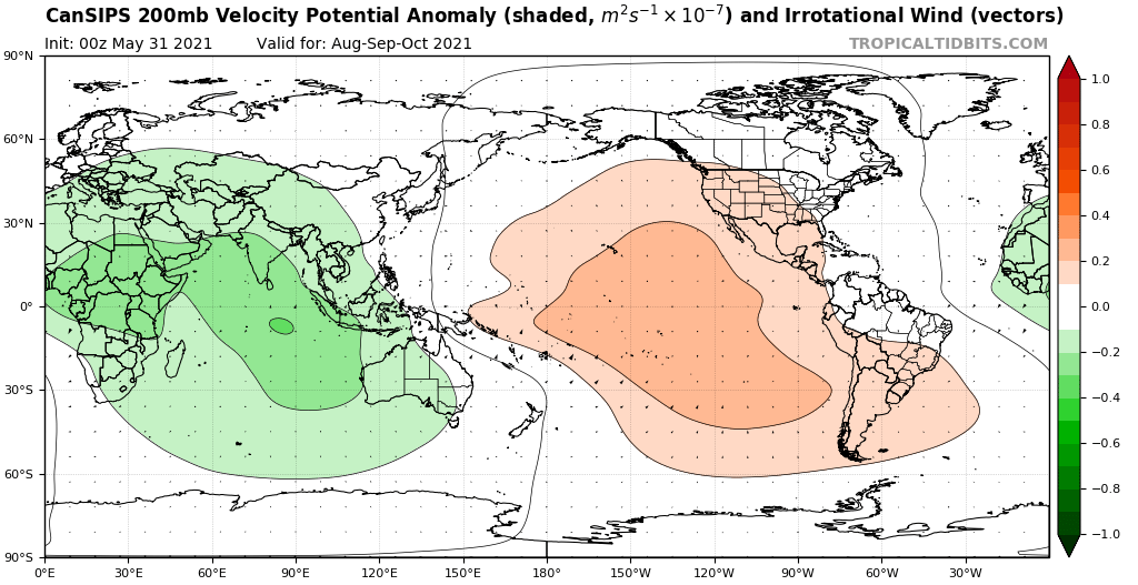
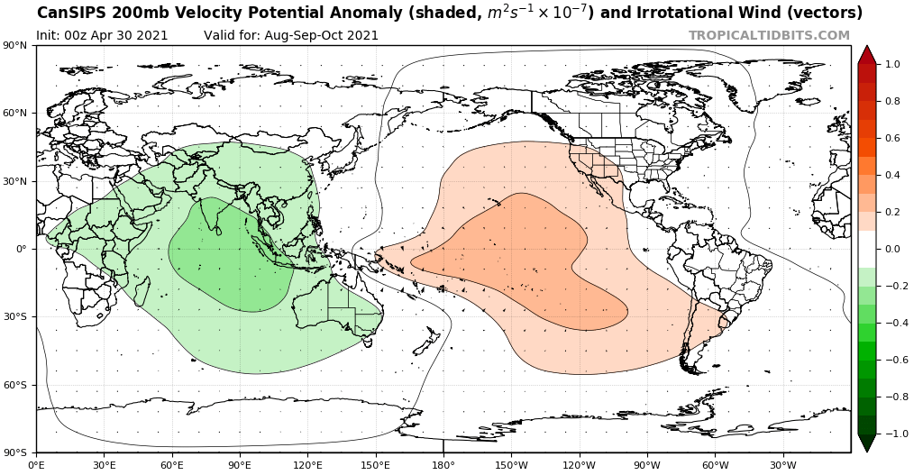
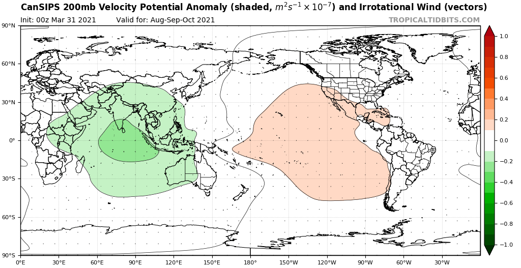
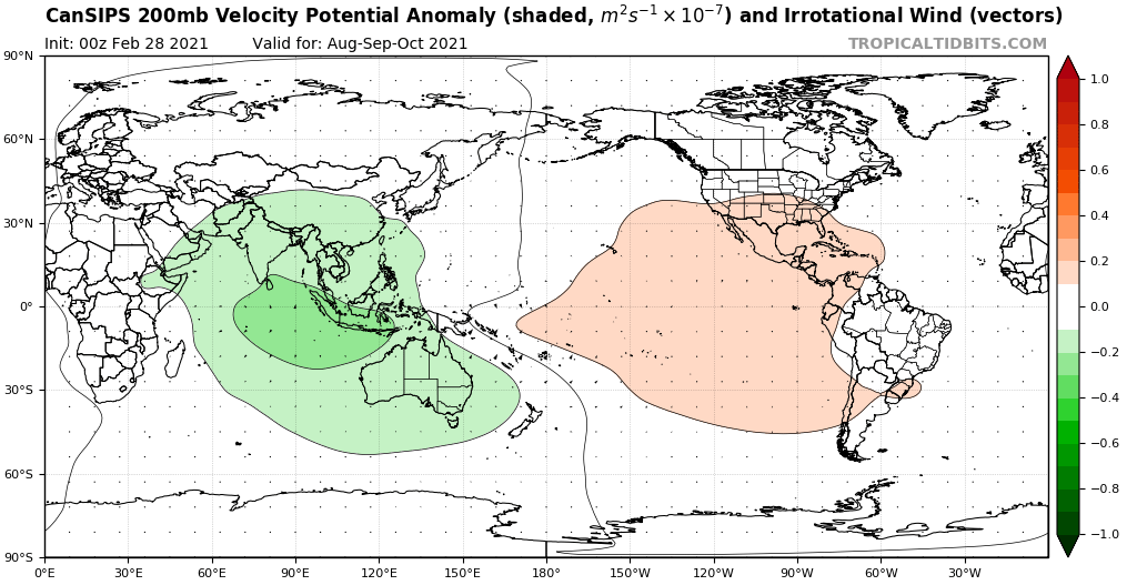
AlphaToOmega wrote:https://i.postimg.cc/g0QxVWTX/cansips-chi200-Mean-month-global-2.png
https://i.postimg.cc/pdp95TqM/cansips-chi200-Mean-month-global-3.png
https://i.postimg.cc/CxvBKDC4/cansips-chi200-Mean-month-global-4.png
https://i.postimg.cc/L84gRvPX/cansips-chi200-Mean-month-global-5.png
https://i.postimg.cc/yYy3w2kt/cansips-chi200-Mean-month-global-6.png
MarioProtVI wrote:Shell Mound wrote:MarioProtVI wrote:Not buying into the GFS’s EPac major spam. ... The monsoon trough setup could easily fix itself by late August and still contribute to a decent MDR season. Finally, the -AMO look is complete crap...
The latest ECMWF has shifted toward the GFS and now shows multiple strong hurricanes over the C/EPAC during the next few weeks. As far as the African monsoonal trough is concerned, the -VP over the IO during ASO should continue to contribute to highly amplified AEWs. These would tend to take their time to consolidate over the MDR, so if a secondary -VP cell is also present over the C/EPAC, it would likely shear any AEW that attempts to develop closer to the Caribbean and/or the islands. Regarding the -AMO, I was referring to the fact that the Canary Current remains cool, despite recent warming of the MDR. One would need to see significant warming over key areas such as the Canaries to be relatively certain that the MDR will continue to warm over time.
The canary current isn’t actually that cool at all. CDAS might be showing that because it’s biased towards cooling with SAL outbreaks making it look cooler then it actually is, thus I would use a different data set such as OISST or Coral Reef
USTropics wrote:Shear is one of the most difficult parameters to forecast, even on an intermediate level (5-10) days. As such, skill level for seasonal shear forecasting is low, and a model blend is typically preferred. As an example, this was the shear forecast last year from the CFS for August and September:
https://i.imgur.com/Uf7NXok.png
https://i.imgur.com/gw7wGa6.png
Specifically for the Atlantic lead time weeks 1 and 2, the shear axis forecasted in the western Caribbean ended up being overestimated (and observed displaced more to the north over north GOM and CONUS). The CFS for lead time weeks 3 and 4 was also too aggressive on the prolonged TUTT axis extending into the Caribbean. Instead, we saw Marco and Laura form in the Caribbean.

Shell Mound wrote:MarioProtVI wrote:Shell Mound wrote:The latest ECMWF has shifted toward the GFS and now shows multiple strong hurricanes over the C/EPAC during the next few weeks. As far as the African monsoonal trough is concerned, the -VP over the IO during ASO should continue to contribute to highly amplified AEWs. These would tend to take their time to consolidate over the MDR, so if a secondary -VP cell is also present over the C/EPAC, it would likely shear any AEW that attempts to develop closer to the Caribbean and/or the islands. Regarding the -AMO, I was referring to the fact that the Canary Current remains cool, despite recent warming of the MDR. One would need to see significant warming over key areas such as the Canaries to be relatively certain that the MDR will continue to warm over time.
The canary current isn’t actually that cool at all. CDAS might be showing that because it’s biased towards cooling with SAL outbreaks making it look cooler then it actually is, thus I would use a different data set such as OISST or Coral Reef
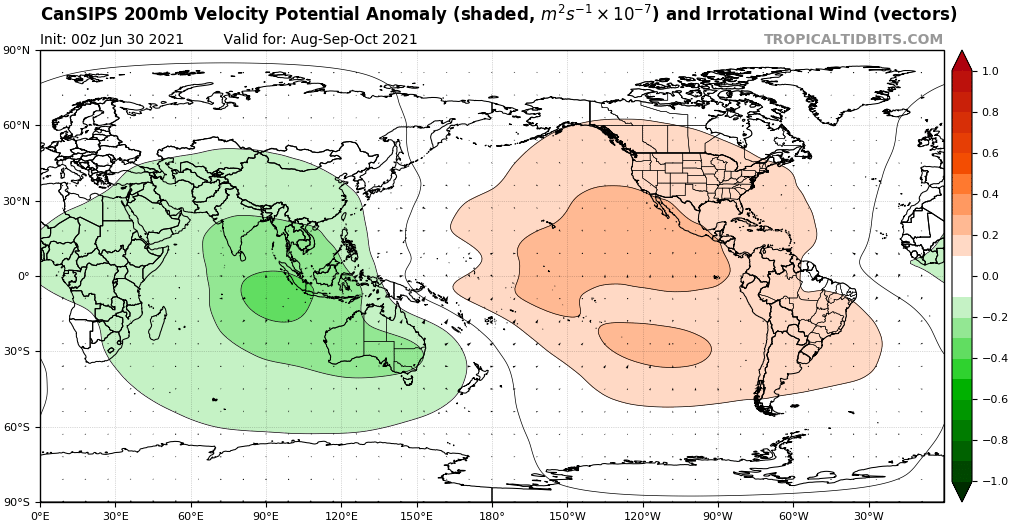
The EPS is shifting toward a much stronger -VP cell over the EPAC through early September, so at this point I think the Atlantic season is going to underperform significantly. The entire month of August is basically going to be dead and early September looks to be far from hospitable for “homegrown” systems, given strong, convectively driven VWS emanating from the EPAC and impinging on the Caribbean. This is significant, because most people here have been expecting “homegrown” development to compensate for a potentially inactive MDR, yet the -VP cell over the EPAC would likely shut down the western part of the basin. Anything that forms there would need to occur along the northern Gulf Coast or off the East Coast, and such a system would be much more likely to be relatively weak than something that forms farther south, i.e., over the western Caribbean.
InfernoFlameCat wrote:SconnieCane wrote:aspen wrote:The OISST seems to have a warm bias. On the CRW map, it’s 0.24C above average. Both agree that the Gulf is roughly 0.55-0.65C warmer that normal, but are very different with the Caribbean: +0.81C (OISST) vs +0.39C (CRW). Regardless, everything is running warmer than average now.
The mean SSTs in the Gulf have risen to 30.01C. This combined with the extra-warm Loop Current really make me concerned about something going bonkers in the Gulf, if it’s given the optimal moisture and shear/UL setup.
The Gulf has been on a tear of late with Harvey (to a lesser extent Nate), Michael, and Hanna/Laura/Sally/Delta/Zeta, only taking 2019 off out of the last four seasons as far as producing hurricanes, some of them major. And they are not following the old "rule" according to the likes of Opal, Ivan, Katrina, Rita, etc; and maintaining or even continuing to intensify at landfall. If that trend doesn't continue in 2021, it won't be because of SSTs/OHC.
Ugly Barry started crying in the background.
Shell Mound wrote:MarioProtVI wrote:Shell Mound wrote:The latest ECMWF has shifted toward the GFS and now shows multiple strong hurricanes over the C/EPAC during the next few weeks. As far as the African monsoonal trough is concerned, the -VP over the IO during ASO should continue to contribute to highly amplified AEWs. These would tend to take their time to consolidate over the MDR, so if a secondary -VP cell is also present over the C/EPAC, it would likely shear any AEW that attempts to develop closer to the Caribbean and/or the islands. Regarding the -AMO, I was referring to the fact that the Canary Current remains cool, despite recent warming of the MDR. One would need to see significant warming over key areas such as the Canaries to be relatively certain that the MDR will continue to warm over time.
The canary current isn’t actually that cool at all. CDAS might be showing that because it’s biased towards cooling with SAL outbreaks making it look cooler then it actually is, thus I would use a different data set such as OISST or Coral Reef
The EPS is shifting toward a much stronger -VP cell over the EPAC through early September, so at this point I think the Atlantic season is going to underperform significantly. The entire month of August is basically going to be dead and early September looks to be far from hospitable for “homegrown” systems, given strong, convectively driven VWS emanating from the EPAC and impinging on the Caribbean. This is significant, because most people here have been expecting “homegrown” development to compensate for a potentially inactive MDR, yet the -VP cell over the EPAC would likely shut down the western part of the basin. Anything that forms there would need to occur along the northern Gulf Coast or off the East Coast, and such a system would be much more likely to be relatively weak than something that forms farther south, i.e., over the western Caribbean.

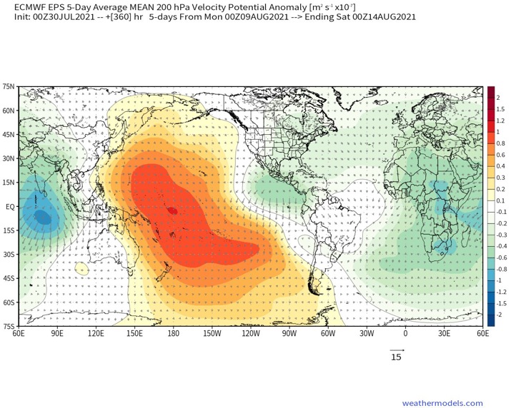
AlphaToOmega wrote:https://i.postimg.cc/5tkmLNTW/msfh-UYym-SL.png
A -VP EPac cell does not mean an inactive season.
aspen wrote:AlphaToOmega wrote:https://i.postimg.cc/5tkmLNTW/msfh-UYym-SL.png
A -VP EPac cell does not mean an inactive season.
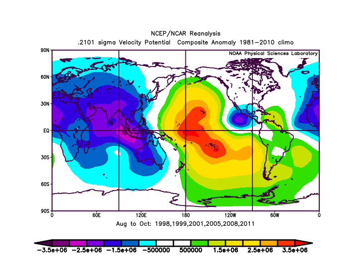
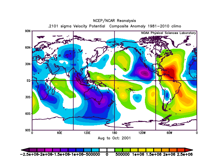
2001 might be a good analogue year, although I think 2021 will probably outperform it a bit. That season saw a July MDR depression, multiple low-latitude systems (Chantal, Iris, Jerry), and late season WCar activity. This year, the low ITCZ will help favor lower-latitude MDR systems, and the onset of a La Niña combined with the favorable VP setup forecast for October-November seems like it’ll favor late-season activity like 2001 and 2020 (although hopefully nowhere near as insane as the latter). What was the VP setup in August 2001?

SconnieCane wrote:InfernoFlameCat wrote:SconnieCane wrote:
The Gulf has been on a tear of late with Harvey (to a lesser extent Nate), Michael, and Hanna/Laura/Sally/Delta/Zeta, only taking 2019 off out of the last four seasons as far as producing hurricanes, some of them major. And they are not following the old "rule" according to the likes of Opal, Ivan, Katrina, Rita, etc; and maintaining or even continuing to intensify at landfall. If that trend doesn't continue in 2021, it won't be because of SSTs/OHC.
Ugly Barry started crying in the background.
Whoops, forgot about that abomination (also Marco, although it didn't make landfall as such). So, we actually are on an unbroken four-season streak of hurricanes in the Gulf, three of them with at least one major hurricane.
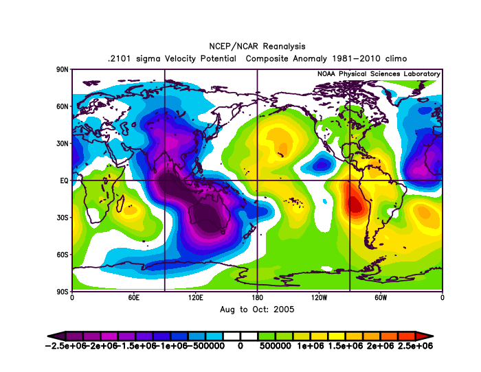
AlphaToOmega wrote:https://i.postimg.cc/T1x5WzdX/uk1824-Tqdx.png
2005 illustrates this point quite nicely. The year of Dennis, Emily, Katrina, Rita, Wilma, and Beta, all Western Atlantic hurricanes, had a -VP cell over the East Pacific. It is dangerous to cancel a season over an EPac cell.
MarioProtVI wrote:Shell Mound wrote:MarioProtVI wrote:The canary current isn’t actually that cool at all. CDAS might be showing that because it’s biased towards cooling with SAL outbreaks making it look cooler then it actually is, thus I would use a different data set such as OISST or Coral Reef
The EPS is shifting toward a much stronger -VP cell over the EPAC through early September, so at this point I think the Atlantic season is going to underperform significantly. The entire month of August is basically going to be dead and early September looks to be far from hospitable for “homegrown” systems, given strong, convectively driven VWS emanating from the EPAC and impinging on the Caribbean. This is significant, because most people here have been expecting “homegrown” development to compensate for a potentially inactive MDR, yet the -VP cell over the EPAC would likely shut down the western part of the basin. Anything that forms there would need to occur along the northern Gulf Coast or off the East Coast, and such a system would be much more likely to be relatively weak than something that forms farther south, i.e., over the western Caribbean.
Literally all other factors point to an above-average season. I don’t know why you’re so confident the Atlantic is going to underperform and your basically suggesting the season might 2013 itself. Come November 30 I am 100% certain that is going to age poorly. Things can change quickly and models are not all the same and can verify poorly like last year.
Shell Mound wrote:MarioProtVI wrote:Shell Mound wrote:The latest ECMWF has shifted toward the GFS and now shows multiple strong hurricanes over the C/EPAC during the next few weeks. As far as the African monsoonal trough is concerned, the -VP over the IO during ASO should continue to contribute to highly amplified AEWs. These would tend to take their time to consolidate over the MDR, so if a secondary -VP cell is also present over the C/EPAC, it would likely shear any AEW that attempts to develop closer to the Caribbean and/or the islands. Regarding the -AMO, I was referring to the fact that the Canary Current remains cool, despite recent warming of the MDR. One would need to see significant warming over key areas such as the Canaries to be relatively certain that the MDR will continue to warm over time.
The canary current isn’t actually that cool at all. CDAS might be showing that because it’s biased towards cooling with SAL outbreaks making it look cooler then it actually is, thus I would use a different data set such as OISST or Coral Reef
The EPS is shifting toward a much stronger -VP cell over the EPAC through early September, so at this point I think the Atlantic season is going to underperform significantly. The entire month of August is basically going to be dead and early September looks to be far from hospitable for “homegrown” systems, given strong, convectively driven VWS emanating from the EPAC and impinging on the Caribbean. This is significant, because most people here have been expecting “homegrown” development to compensate for a potentially inactive MDR, yet the -VP cell over the EPAC would likely shut down the western part of the basin. Anything that forms there would need to occur along the northern Gulf Coast or off the East Coast, and such a system would be much more likely to be relatively weak than something that forms farther south, i.e., over the western Caribbean.
AlphaToOmega wrote:aspen wrote:AlphaToOmega wrote:https://i.postimg.cc/5tkmLNTW/msfh-UYym-SL.png
A -VP EPac cell does not mean an inactive season.
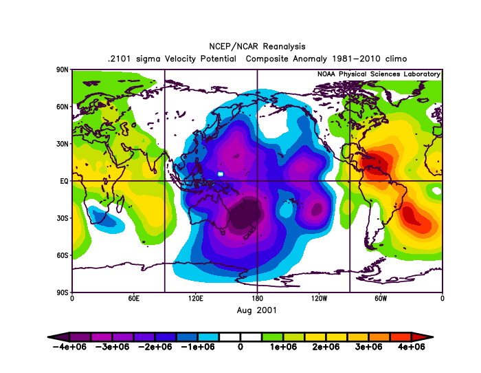
2001 might be a good analogue year, although I think 2021 will probably outperform it a bit. That season saw a July MDR depression, multiple low-latitude systems (Chantal, Iris, Jerry), and late season WCar activity. This year, the low ITCZ will help favor lower-latitude MDR systems, and the onset of a La Niña combined with the favorable VP setup forecast for October-November seems like it’ll favor late-season activity like 2001 and 2020 (although hopefully nowhere near as insane as the latter). What was the VP setup in August 2001?
https://i.postimg.cc/HkYKtnZr/Uzkn-BSd-Th.png
This setup is theoretically terrible for Atlantic tropical activity; but Barry, Chantal, and Dean would say otherwise.
aspen wrote:Shell Mound wrote:MarioProtVI wrote:The canary current isn’t actually that cool at all. CDAS might be showing that because it’s biased towards cooling with SAL outbreaks making it look cooler then it actually is, thus I would use a different data set such as OISST or Coral Reef
The EPS is shifting toward a much stronger -VP cell over the EPAC through early September, so at this point I think the Atlantic season is going to underperform significantly. The entire month of August is basically going to be dead and early September looks to be far from hospitable for “homegrown” systems, given strong, convectively driven VWS emanating from the EPAC and impinging on the Caribbean. This is significant, because most people here have been expecting “homegrown” development to compensate for a potentially inactive MDR, yet the -VP cell over the EPAC would likely shut down the western part of the basin. Anything that forms there would need to occur along the northern Gulf Coast or off the East Coast, and such a system would be much more likely to be relatively weak than something that forms farther south, i.e., over the western Caribbean.
If this wasn’t a weak Nina year then that could be possible. However, because of that -ENSO, the EPac will struggle even with a -VP cell. Many storms have struggled to intensify this season, and while Felicia was able to find success, it didn’t undergo RI until it was far from Mexico. If future systems continue to follow these trends — which seems probable based on the progress of 99E and 90E — shear from a bunch of strong EPac storms probably will not be an issue. Also, as Alpha has pointed out, there are other examples of seasons ranging from “typical” above-normal to hyperactive that saw a -VP cell sometime during ASO, so it’s not a season killer, especially when -ENSO is on the Atlantic’s side. The -VP cell might prevent the Caribbean from being ultra-favorable like last year and perhaps limit some storms, but it won’t prevent systems that people will need to watch out for.
aspen wrote:AlphaToOmega wrote:aspen wrote:2001 might be a good analogue year, although I think 2021 will probably outperform it a bit. That season saw a July MDR depression, multiple low-latitude systems (Chantal, Iris, Jerry), and late season WCar activity. This year, the low ITCZ will help favor lower-latitude MDR systems, and the onset of a La Niña combined with the favorable VP setup forecast for October-November seems like it’ll favor late-season activity like 2001 and 2020 (although hopefully nowhere near as insane as the latter). What was the VP setup in August 2001?
https://i.postimg.cc/HkYKtnZr/Uzkn-BSd-Th.png
This setup is theoretically terrible for Atlantic tropical activity; but Barry, Chantal, and Dean would say otherwise.
Okay scratch that, 2001 is an awful analogue year. The rising branch is way too far east compared to 2021 and the last few years.


Shell Mound wrote:MarioProtVI wrote:Shell Mound wrote:The latest ECMWF has shifted toward the GFS and now shows multiple strong hurricanes over the C/EPAC during the next few weeks. As far as the African monsoonal trough is concerned, the -VP over the IO during ASO should continue to contribute to highly amplified AEWs. These would tend to take their time to consolidate over the MDR, so if a secondary -VP cell is also present over the C/EPAC, it would likely shear any AEW that attempts to develop closer to the Caribbean and/or the islands. Regarding the -AMO, I was referring to the fact that the Canary Current remains cool, despite recent warming of the MDR. One would need to see significant warming over key areas such as the Canaries to be relatively certain that the MDR will continue to warm over time.
The canary current isn’t actually that cool at all. CDAS might be showing that because it’s biased towards cooling with SAL outbreaks making it look cooler then it actually is, thus I would use a different data set such as OISST or Coral Reef
The EPS is shifting toward a much stronger -VP cell over the EPAC through early September, so at this point I think the Atlantic season is going to underperform significantly. The entire month of August is basically going to be dead and early September looks to be far from hospitable for “homegrown” systems, given strong, convectively driven VWS emanating from the EPAC and impinging on the Caribbean. This is significant, because most people here have been expecting “homegrown” development to compensate for a potentially inactive MDR, yet the -VP cell over the EPAC would likely shut down the western part of the basin. Anything that forms there would need to occur along the northern Gulf Coast or off the East Coast, and such a system would be much more likely to be relatively weak than something that forms farther south, i.e., over the western Caribbean.
Users browsing this forum: WaveBreaking and 287 guests

