2021 Indicators: SST's / SAL / MSLP / Shear / Steering / Instability / Sat Images
Moderator: S2k Moderators
Forum rules

The posts in this forum are NOT official forecasts and should not be used as such. They are just the opinion of the poster and may or may not be backed by sound meteorological data. They are NOT endorsed by any professional institution or STORM2K. For official information, please refer to products from the National Hurricane Center and National Weather Service.
-
cheezyWXguy

- Category 5

- Posts: 6282
- Joined: Mon Feb 13, 2006 12:29 am
- Location: Dallas, TX
Re: 2021 Indicators: SST's / SAL / MSLP / Shear / Steering / Instability / Sat Images
These interpretations a of single long range run of the CFS are verging on hurricane cold reading imo
3 likes
-
SFLcane

- S2K Supporter

- Posts: 10281
- Age: 48
- Joined: Sat Jun 05, 2010 1:44 pm
- Location: Lake Worth Florida
Re: 2021 Indicators: SST's / SAL / MSLP / Shear / Steering / Instability / Sat Images
Ok let’s put his cfs stuff to sleep!
Here is the monthly precipitation for Aug do you guys see we’re the precip is? It’s suggesting tracks similar to that of Elsa. My point is look at the northern atl it’s bone dry.
So please stop
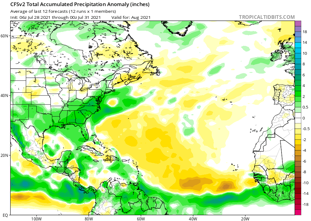
Here is the monthly precipitation for Aug do you guys see we’re the precip is? It’s suggesting tracks similar to that of Elsa. My point is look at the northern atl it’s bone dry.
So please stop
Last edited by SFLcane on Sat Jul 31, 2021 9:36 am, edited 1 time in total.
1 likes
-
Category5Kaiju

- Category 5
- Posts: 4334
- Joined: Thu Dec 24, 2020 12:45 pm
- Location: Seattle and Phoenix
Re: 2021 Indicators: SST's / SAL / MSLP / Shear / Steering / Instability / Sat Images
https://twitter.com/tropicalupdate/status/1421457093496823810
Btw I personally have not seen this source talked about a lot on this particular thread, but have you guys ever heard of Mike's Weatherpage? I occasionally find his tweets on models, conditions, and what not to be a decent source of tropical weather info (particularly during lulls like these) along with the usual Mark Sudduth, Eric Webb, Ben Noll, Phil Klotzbach, Andy Hazelton, etc. group
Btw I personally have not seen this source talked about a lot on this particular thread, but have you guys ever heard of Mike's Weatherpage? I occasionally find his tweets on models, conditions, and what not to be a decent source of tropical weather info (particularly during lulls like these) along with the usual Mark Sudduth, Eric Webb, Ben Noll, Phil Klotzbach, Andy Hazelton, etc. group
0 likes
Unless explicitly stated, all info in my posts is based on my own opinions and observations. Tropical storms and hurricanes can be extremely dangerous. Refer to an accredited weather research agency or meteorologist if you need to make serious decisions regarding an approaching storm.
-
SconnieCane
- Category 5
- Posts: 1013
- Joined: Thu Aug 02, 2018 5:29 pm
- Location: Madison, WI
Re: 2021 Indicators: SST's / SAL / MSLP / Shear / Steering / Instability / Sat Images
Sudduth pretty much flies in the face (couldn't get video to embed) of everything Shell Mound has been saying, calling for high ACE-producers coming out of the MDR.
7 likes
-
SFLcane
- S2K Supporter
- Posts: 10281
- Age: 48
- Joined: Sat Jun 05, 2010 1:44 pm
- Location: Lake Worth Florida
Re: 2021 Indicators: SST's / SAL / MSLP / Shear / Steering / Instability / Sat Images
I have no doubt now the train is coming! Be ready folks
11 likes
-
captainbarbossa19

- Professional-Met

- Posts: 1094
- Age: 27
- Joined: Wed Aug 21, 2019 11:09 pm
- Location: Beaumont, TX
Re: 2021 Indicators: SST's / SAL / MSLP / Shear / Steering / Instability / Sat Images
SconnieCane wrote:Sudduth pretty much flies in the face (couldn't get video to embed) of everything Shell Mound has been saying, calling for high ACE-producers coming out of the MDR.
I remember watching his presentations before. He does a great job and keeps them interesting. Sadly, I think there is a lot of evidence to support his claims of this year resembling the 2017 season. I like how he pointed out that the EPAC has been active, but has not really been producing many high ACE storms.
5 likes
-
gatorcane

- S2K Supporter
- Posts: 23708
- Age: 48
- Joined: Sun Mar 13, 2005 3:54 pm
- Location: Boca Raton, FL
Re: 2021 Indicators: SST's / SAL / MSLP / Shear / Steering / Instability / Sat Images
Looks pretty typical out there as we head into August. All the action over the EPAC, dry and dusty over the Atlantic…for now:
5 likes
-
tolakram
- Admin

- Posts: 20186
- Age: 62
- Joined: Sun Aug 27, 2006 8:23 pm
- Location: Florence, KY (name is Mark)
Re: 2021 Indicators: SST's / SAL / MSLP / Shear / Steering / Instability / Sat Images
The MJO propagates eastward, so I expect the gulf will be favorable first and those conditions will move east. Very similar to 2017 when waves struggled until the were far enough west. Every year it seems like we expect the eastern part of the basin to get active first. Why is this? What am I missing?
In 2017, as the MJO propagated east, we had Harvey in the Gulf, then Irma, then Jose. Katia could have gotten to cat 3 had it formed just a little earlier, but conditions in the western gulf were already becoming less productive.
Every year is different, and other than compare how 2017 behaved I'm not suggesting a 2017 repeat, but generally if disturbances are there this is usually what I expect. West first.
2020 very similar pattern. Laura struggled until the Gulf, eventually a month later Teddy much further east.
11 likes
M a r k
- - - - -
Join us in chat: Storm2K Chatroom Invite. Android and IOS apps also available.
The posts in this forum are NOT official forecasts and should not be used as such. Posts are NOT endorsed by any professional institution or STORM2K.org. For official information and forecasts, please refer to NHC and NWS products.
-
Category5Kaiju
- Category 5
- Posts: 4334
- Joined: Thu Dec 24, 2020 12:45 pm
- Location: Seattle and Phoenix
Re: 2021 Indicators: SST's / SAL / MSLP / Shear / Steering / Instability / Sat Images
Let's nejoy the quiet while we can, because with this prediction at least August looks to be wicked.
https://twitter.com/MJVentrice/status/1421454190832988160
https://twitter.com/MJVentrice/status/1421454190832988160
1 likes
Unless explicitly stated, all info in my posts is based on my own opinions and observations. Tropical storms and hurricanes can be extremely dangerous. Refer to an accredited weather research agency or meteorologist if you need to make serious decisions regarding an approaching storm.
Re: 2021 Indicators: SST's / SAL / MSLP / Shear / Steering / Instability / Sat Images
Well gang we have made it to the eve of the "real season" getting underway. The annual climo ramp climb begins tomorrow and runs pretty much parabolic for 40 days and 40 nights to its Sept 10 peak. Since it starts from a pretty low baseline we need to run for awhile before we're entitled to much...hence the 8-20 bell ring...which resides about halfway up climo mountain. Favorable lift might get here a tad sooner...so 8-10 to 8-20 might be a reasonable time to begin to expect something. 10 or 20 days or so...Oh my it's close...
10 likes
-
Category5Kaiju
- Category 5
- Posts: 4334
- Joined: Thu Dec 24, 2020 12:45 pm
- Location: Seattle and Phoenix
Re: 2021 Indicators: SST's / SAL / MSLP / Shear / Steering / Instability / Sat Images
psyclone wrote:Well gang we have made it to the eve of the "real season" getting underway. The annual climo ramp climb begins tomorrow and runs pretty much parabolic for 40 days and 40 nights to its Sept 10 peak. Since it starts from a pretty low baseline we need to run for awhile before we're entitled to much...hence the 8-20 bell ring...which resides about halfway up climo mountain. Favorable lift might get here a tad sooner...so 8-10 to 8-20 might be a reasonable time to begin to expect something. 10 or 20 days or so...Oh my it's close...
It's that time of the year, I guess. August, the end of summer vacation and the return to school but also the beginning of hurricane tracking fever
5 likes
Unless explicitly stated, all info in my posts is based on my own opinions and observations. Tropical storms and hurricanes can be extremely dangerous. Refer to an accredited weather research agency or meteorologist if you need to make serious decisions regarding an approaching storm.
-
cycloneye

- Admin
- Posts: 149505
- Age: 69
- Joined: Thu Oct 10, 2002 10:54 am
- Location: San Juan, Puerto Rico
Re: 2021 Indicators: SST's / SAL / MSLP / Shear / Steering / Instability / Sat Images
0 likes
Visit the Caribbean-Central America Weather Thread where you can find at first post web cams,radars
and observations from Caribbean basin members Click Here
and observations from Caribbean basin members Click Here

Re: 2021 Indicators: SST's / SAL / MSLP / Shear / Steering / Instability / Sat Images
SFLcane wrote:Ok let’s put his cfs stuff to sleep!
Here is the monthly precipitation for Aug do you guys see we’re the precip is? It’s suggesting tracks similar to that of Elsa. My point is look at the northern atl it’s bone dry.
So please stop
https://i.postimg.cc/1zQQ8vZC/132-DC0-D5-AD0-F-48-DA-A2-F6-1337416-B97-B1.png
You are literally using the very same CFS model that I am, and August is not the entire season. September lines up with what the surface runs were showing, as that's when the bulk of the Atlantic-specific activity was (similar to last year)

At no point did I say there would not be threats, but that if there is more activity in the eastern MDR there would naturally be a higher number of recurves and long-trackers, something that has been. I explicitly noted that there were several instances of storms threatening the southeast and that Gulf of Mexico data was not available as the maps haven't been loading:
Hammy wrote:Gulf/Caribbean maps are not loading beyond about 400h but there were a few storms that crossed over Florida and appeared to strengthen after so that could be a hot spot.
Something similar to 1995, or perhaps a version of 1999 that's shifted a few hundred miles west, looks to be the most likely outcome for the season at this point--a lot of recurves, and a lot of SEUS activity, and (at least for September) a relatively quiet Caribbean.
0 likes
The above post is not official and should not be used as such. It is the opinion of the poster and may or may not be backed by sound meteorological data. It is not endorsed by any professional institution or storm2k.org. For official information, please refer to the NHC and NWS products.
-
Category5Kaiju
- Category 5
- Posts: 4334
- Joined: Thu Dec 24, 2020 12:45 pm
- Location: Seattle and Phoenix
Re: 2021 Indicators: SST's / SAL / MSLP / Shear / Steering / Instability / Sat Images
In terms of steering patterns, I personally think these models can capture general patterns, but I am not exactly sure how specific or reliable they can possibly get given ridging and troughing really are dynamic and can be influenced by a myriad of ever-so changing factors. To complicate things, I have been hearing some people say more OTS and recurves will happen this year and others say that a 2004-like land impact season is not out of the cards. However, if past storms are any predictors of what's to come, if we do see storms like Elsa later this season be favored (in the sense that they develop and depart the MDR at low latitudes), then that could possibly make recurves more difficult and land impacts more likely the way I see it.
0 likes
Unless explicitly stated, all info in my posts is based on my own opinions and observations. Tropical storms and hurricanes can be extremely dangerous. Refer to an accredited weather research agency or meteorologist if you need to make serious decisions regarding an approaching storm.
-
CyclonicFury

- Category 5
- Posts: 2035
- Age: 27
- Joined: Sun Jul 02, 2017 12:32 pm
- Location: NC
- Contact:
Re: 2021 Indicators: SST's / SAL / MSLP / Shear / Steering / Instability / Sat Images
Category5Kaiju wrote:In terms of steering patterns, I personally think these models can capture general patterns, but I am not exactly sure how specific or reliable they can possibly get given ridging and troughing really are dynamic and can be influenced by a myriad of ever-so changing factors. To complicate things, I have been hearing some people say more OTS and recurves will happen this year and others say that a 2004-like land impact season is not out of the cards. However, if past storms are any predictors of what's to come, if we do see storms like Elsa later this season be favored (in the sense that they develop and depart the MDR at low latitudes), then that could possibly make recurves more difficult and land impacts more likely the way I see it.
Personally, in my opinion it's too early to definitively say which areas will and won't be hit. Exact TC tracks come down to specific synoptic details when storms are active. It's very premature to say any area is "off the hook" or "safe" from TC impacts. Many thought that because of its near-record cold MDR, 2018 would have nothing from the MDR impact the U.S., yet Florence survived the entire trek and hit NC as a hurricane. I'm not convinced the MDR will be quiet this year, in fact I could see a few hurricanes there and maybe a major.
2 likes
NCSU B.S. in Meteorology Class of 2021. Tropical weather blogger at http://www.cyclonicfury.com. My forecasts and thoughts are NOT official, for official forecasts please consult the National Hurricane Center.
-
Yellow Evan

- Professional-Met
- Posts: 16240
- Age: 27
- Joined: Fri Jul 15, 2011 12:48 pm
- Location: Henderson, Nevada/Honolulu, HI
- Contact:
Re: 2021 Indicators: SST's / SAL / MSLP / Shear / Steering / Instability / Sat Images
tolakram wrote:The MJO propagates eastward, so I expect the gulf will be favorable first and those conditions will move east. Very similar to 2017 when waves struggled until the were far enough west. Every year it seems like we expect the eastern part of the basin to get active first. Why is this? What am I missing?
In 2017, as the MJO propagated east, we had Harvey in the Gulf, then Irma, then Jose. Katia could have gotten to cat 3 had it formed just a little earlier, but conditions in the western gulf were already becoming less productive.
Every year is different, and other than compare how 2017 behaved I'm not suggesting a 2017 repeat, but generally if disturbances are there this is usually what I expect. West first.
2020 very similar pattern. Laura struggled until the Gulf, eventually a month later Teddy much further east.

MJO was basically irrelevant in 2017 outside of shutting the basin down later in the year. A CCKW did spark Harvey IIRC but most of the infamous activity was fueled by the favorable base state rather than upper atmospheric waves.
Last edited by Yellow Evan on Sat Jul 31, 2021 8:30 pm, edited 1 time in total.
6 likes
-
AxaltaRacing24
- Category 5
- Posts: 1774
- Age: 25
- Joined: Wed Jul 27, 2016 11:14 am
- Location: Jupiter, FL
Re: 2021 Indicators: SST's / SAL / MSLP / Shear / Steering / Instability / Sat Images
CyclonicFury wrote:Category5Kaiju wrote:In terms of steering patterns, I personally think these models can capture general patterns, but I am not exactly sure how specific or reliable they can possibly get given ridging and troughing really are dynamic and can be influenced by a myriad of ever-so changing factors. To complicate things, I have been hearing some people say more OTS and recurves will happen this year and others say that a 2004-like land impact season is not out of the cards. However, if past storms are any predictors of what's to come, if we do see storms like Elsa later this season be favored (in the sense that they develop and depart the MDR at low latitudes), then that could possibly make recurves more difficult and land impacts more likely the way I see it.
Personally, in my opinion it's too early to definitively say which areas will and won't be hit. Exact TC tracks come down to specific synoptic details when storms are active. It's very premature to say any area is "off the hook" or "safe" from TC impacts. Many thought that because of its near-record cold MDR, 2018 would have nothing from the MDR impact the U.S., yet Florence survived the entire trek and hit NC as a hurricane. I'm not convinced the MDR will be quiet this year, in fact I could see a few hurricanes there and maybe a major.
There is no reason to expect a "dead" MDR. The area is ABOVE AVERAGE and will certainty be capable of having hurricanes.
4 likes
-
TROPICALCYCLONEALERT
- Tropical Low

- Posts: 32
- Joined: Thu Feb 20, 2020 9:28 pm
Re: 2021 Indicators: SST's / SAL / MSLP / Shear / Steering / Instability / Sat Images
tolakram wrote:The MJO propagates eastward, so I expect the gulf will be favorable first and those conditions will move east. Very similar to 2017 when waves struggled until the were far enough west. Every year it seems like we expect the eastern part of the basin to get active first. Why is this? What am I missing?
In 2017, as the MJO propagated east, we had Harvey in the Gulf, then Irma, then Jose. Katia could have gotten to cat 3 had it formed just a little earlier, but conditions in the western gulf were already becoming less productive.
Every year is different, and other than compare how 2017 behaved I'm not suggesting a 2017 repeat, but generally if disturbances are there this is usually what I expect. West first.
2020 very similar pattern. Laura struggled until the Gulf, eventually a month later Teddy much further east.
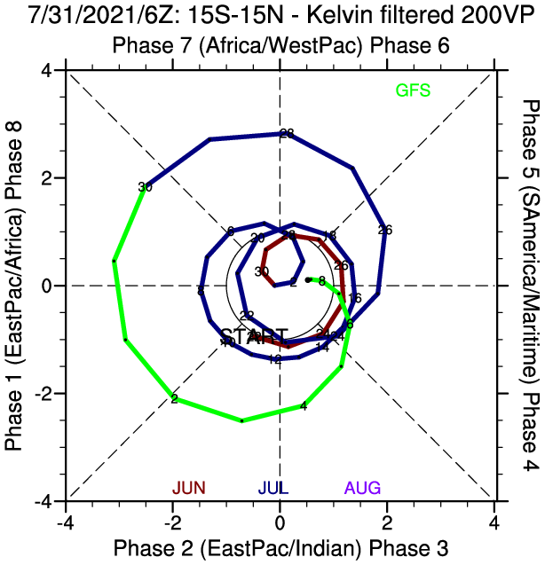
Glancing at the BOM's RMM chart archive, I'd be cautious placing blame for 2017's burst of activity on an MJO pulse. For most of the month, the oscillation actually had a weak signal, and resided in null on the diagram. It later amplified into the Western Pacific come October, likely sparking the monsoon trough that slowly coalesced into STY Lan, while also shutting down the Atlantic outside of some weaker storms and Ophelia.
https://cdn.discordapp.com/attachments/ ... 201707.png
6 likes
-
Category5Kaiju
- Category 5
- Posts: 4334
- Joined: Thu Dec 24, 2020 12:45 pm
- Location: Seattle and Phoenix
Re: 2021 Indicators: SST's / SAL / MSLP / Shear / Steering / Instability / Sat Images
TROPICALCYCLONEALERT wrote:tolakram wrote:The MJO propagates eastward, so I expect the gulf will be favorable first and those conditions will move east. Very similar to 2017 when waves struggled until the were far enough west. Every year it seems like we expect the eastern part of the basin to get active first. Why is this? What am I missing?
In 2017, as the MJO propagated east, we had Harvey in the Gulf, then Irma, then Jose. Katia could have gotten to cat 3 had it formed just a little earlier, but conditions in the western gulf were already becoming less productive.
Every year is different, and other than compare how 2017 behaved I'm not suggesting a 2017 repeat, but generally if disturbances are there this is usually what I expect. West first.
2020 very similar pattern. Laura struggled until the Gulf, eventually a month later Teddy much further east.
Glancing at the BOM's RMM chart archive, I'd be cautious placing blame for 2017's burst of activity on an MJO pulse. For most of the month, the oscillation actually had a weak signal, and resided in null on the diagram. It later amplified into the Western Pacific come October, likely sparking the monsoon trough that slowly coalesced into STY Lan, while also shutting down the Atlantic outside of some weaker storms and Ophelia.
https://cdn.discordapp.com/attachments/ ... 201707.png
2017 sure did end somewhat early; when I first tracked that season I thought we were about to get 19 or so NSs, but it seemed like the basin pretty much shut down its big guns activity right after September was done. It was interesting to say the least
0 likes
Unless explicitly stated, all info in my posts is based on my own opinions and observations. Tropical storms and hurricanes can be extremely dangerous. Refer to an accredited weather research agency or meteorologist if you need to make serious decisions regarding an approaching storm.
-
Kingarabian

- S2K Supporter
- Posts: 16366
- Joined: Sat Aug 08, 2009 3:06 am
- Location: Honolulu, Hawaii
Re: 2021 Indicators: SST's / SAL / MSLP / Shear / Steering / Instability / Sat Images
Even if the MJO signal is in the circle, it still means the MJO is moving somewhere around the planet. The MJO signal per RMM was very weak in 2017, but it was at least not in the Atlantic inactive phase for the month of August and most of September. That in itself means the MJO is actually playing a role in enhanced TC activity. This will also be true in about 2 weeks from now. In terms of Climo, the MJO is very weak during the summer months and even through September, compared to late fall and early winter. it takes very little MJO amplitude (which is easier to see on hovmollers than RMM during these months) to trigger TCG.
The current MJO event over the Pacific is actually much stronger than normal considering the time of year, and if it ends up in the Atlantic, we should expect a big uptick in activity similar to what we're currently seeing in the EPAC.
The current MJO event over the Pacific is actually much stronger than normal considering the time of year, and if it ends up in the Atlantic, we should expect a big uptick in activity similar to what we're currently seeing in the EPAC.
Last edited by Kingarabian on Sat Jul 31, 2021 6:33 pm, edited 1 time in total.
6 likes
RIP Kobe Bryant
Who is online
Users browsing this forum: USTropics and 317 guests