2021 Global Model Runs Discussion (Out thru day 16)

This is the general tropical discussion area. Anyone can take their shot at predicting a storms path.

Moderator: S2k Moderators

Forum rules

The posts in this forum are NOT official forecasts and should not be used as such. They are just the opinion of the poster and may or may not be backed by sound meteorological data. They are NOT endorsed by any professional institution or STORM2K. For official information, please refer to products from the National Hurricane Center and National Weather Service.

Help Support Storm2K
Message
Author
User avatar
aspen
Category 5
Category 5
Posts: 8818
Joined: Sat Oct 12, 2019 7:10 pm
Location: Connecticut, USA

Re: 2021 Global Model Runs Discussion (Out thru day 16)

#421 Postby aspen » Sat Jul 31, 2021 6:06 pm

Stormybajan wrote:
aspen wrote:
Hammy wrote:Euro has a couple of potential systems in about a week.

https://i.imgur.com/VUIza8p.png

Given the GFS run from earlier and the models being inconsistent/not developing anything beyond five days before, this looks like it could be the start of August activity.

The MDR system from the earlier GFS runs and now this Euro run also appears in the CFS model, pretty much the exact same position and time.


Is there any link to this CFS forecast?

Here’s the loop Hammy was using in the indicators thread: https://www.weatheronline.co.uk/cgi-bin ... &RES=0

The CFS is actually pretty excited about development and has a TC coming right off of Africa in about 5-6 days, but beyond that this “future Fred” has a very similar position and time frame as it does in the Euro run.
1 likes   
Irene '11 Sandy '12 Hermine '16 5/15/2018 Derecho Fay '20 Isaias '20 Elsa '21 Henri '21 Ida '21

I am only a meteorology enthusiast who knows a decent amount about tropical cyclones. Look to the professional mets, the NHC, or your local weather office for the best information.

User avatar
cycloneye
Admin
Admin
Posts: 145308
Age: 68
Joined: Thu Oct 10, 2002 10:54 am
Location: San Juan, Puerto Rico

Re: 2021 Global Model Runs Discussion (Out thru day 16)

#422 Postby cycloneye » Sat Jul 31, 2021 7:16 pm

1 likes   
Visit the Caribbean-Central America Weather Thread where you can find at first post web cams,radars
and observations from Caribbean basin members Click Here

User avatar
SFLcane
S2K Supporter
S2K Supporter
Posts: 10163
Age: 47
Joined: Sat Jun 05, 2010 1:44 pm
Location: Lake Worth Florida

Re: 2021 Global Model Runs Discussion (Out thru day 16)

#423 Postby SFLcane » Sat Jul 31, 2021 7:27 pm


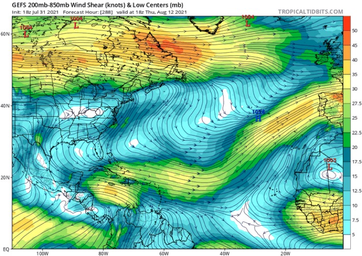
Not gonna happen Luis maybe a brief TD. King TUTT rules August

Image
1 likes   

User avatar
aspen
Category 5
Category 5
Posts: 8818
Joined: Sat Oct 12, 2019 7:10 pm
Location: Connecticut, USA

Re: 2021 Global Model Runs Discussion (Out thru day 16)

#424 Postby aspen » Sat Jul 31, 2021 7:33 pm

SFLcane wrote:


Not gonna happen Luis maybe a brief TD. King TUTT rules August

https://i.postimg.cc/3JMLy9Sv/97-B1-CCC7-F3-D0-440-A-8924-CE64-AECA68-C6.jpg

If it gets strong enough early, maybe we see a situation like Paulette where it gets blasted by a TUTT but survives, and once shear drops again, it’s able to intensify north of 20N.
1 likes   
Irene '11 Sandy '12 Hermine '16 5/15/2018 Derecho Fay '20 Isaias '20 Elsa '21 Henri '21 Ida '21

I am only a meteorology enthusiast who knows a decent amount about tropical cyclones. Look to the professional mets, the NHC, or your local weather office for the best information.

User avatar
Category5Kaiju
Category 5
Category 5
Posts: 4097
Joined: Thu Dec 24, 2020 12:45 pm
Location: Seattle

Re: 2021 Global Model Runs Discussion (Out thru day 16)

#425 Postby Category5Kaiju » Sat Jul 31, 2021 7:37 pm

aspen wrote:
SFLcane wrote:


Not gonna happen Luis maybe a brief TD. King TUTT rules August

https://i.postimg.cc/3JMLy9Sv/97-B1-CCC7-F3-D0-440-A-8924-CE64-AECA68-C6.jpg

If it gets strong enough early, maybe we see a situation like Paulette where it gets blasted by a TUTT but survives, and once shear drops again, it’s able to intensify north of 20N.


Also that is a shear map that is more than 10 days out and reflective of a continously busy EPAC as the GEFS shows; I personally am not sure if that is high confidence level for something that far out in time tbh
7 likes   
Unless explicitly stated, all info in my posts is based on my own opinions and observations. Tropical storms and hurricanes can be extremely dangerous. Do not think you can beat Mother Nature. Refer to an accredited weather research agency or meteorologist if you need to make serious decisions regarding an approaching storm.

User avatar
captainbarbossa19
Professional-Met
Professional-Met
Posts: 1092
Age: 27
Joined: Wed Aug 21, 2019 11:09 pm
Location: Beaumont, TX

Re: 2021 Global Model Runs Discussion (Out thru day 16)

#426 Postby captainbarbossa19 » Sat Jul 31, 2021 9:13 pm

Category5Kaiju wrote:
aspen wrote:
SFLcane wrote:
Not gonna happen Luis maybe a brief TD. King TUTT rules August

https://i.postimg.cc/3JMLy9Sv/97-B1-CCC7-F3-D0-440-A-8924-CE64-AECA68-C6.jpg

If it gets strong enough early, maybe we see a situation like Paulette where it gets blasted by a TUTT but survives, and once shear drops again, it’s able to intensify north of 20N.


Also that is a shear map that is more than 10 days out and reflective of a continously busy EPAC as the GEFS shows; I personally am not sure if that is high confidence level for something that far out in time tbh


Shear maps are often not good more than 72 hours out. Not going to buy that pattern until we get closer.
1 likes   

User avatar
gatorcane
S2K Supporter
S2K Supporter
Posts: 23691
Age: 47
Joined: Sun Mar 13, 2005 3:54 pm
Location: Boca Raton, FL

Re: 2021 Global Model Runs Discussion (Out thru day 16)

#427 Postby gatorcane » Sat Jul 31, 2021 9:17 pm

SFLcane wrote:


Not gonna happen Luis maybe a brief TD. King TUTT rules August

https://i.postimg.cc/3JMLy9Sv/97-B1-CCC7-F3-D0-440-A-8924-CE64-AECA68-C6.jpg


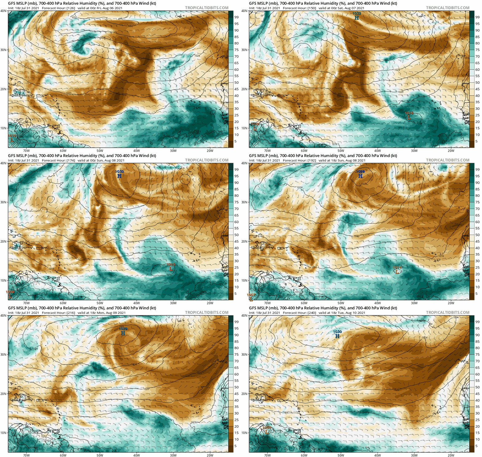
Looks like the GFS also is predicting a large SAL surge from the east which literally squashes this low preventing development. We will see as the run is quite far out:

Image
0 likes   

User avatar
captainbarbossa19
Professional-Met
Professional-Met
Posts: 1092
Age: 27
Joined: Wed Aug 21, 2019 11:09 pm
Location: Beaumont, TX

Re: 2021 Global Model Runs Discussion (Out thru day 16)

#428 Postby captainbarbossa19 » Sat Jul 31, 2021 11:27 pm

Hammy wrote:Euro has a couple of potential systems in about a week.

https://i.imgur.com/VUIza8p.png

Given the GFS run from earlier and the models being inconsistent/not developing anything beyond five days before, this looks like it could be the start of August activity.


One thing to note is that if something does develop, there is a huge ridge over the Atlantic and east coast.
1 likes   

User avatar
AtlanticWind
S2K Supporter
S2K Supporter
Posts: 1888
Age: 66
Joined: Sun Aug 08, 2004 9:57 pm
Location: Plantation,Fla

Re: 2021 Global Model Runs Discussion (Out thru day 16)

#429 Postby AtlanticWind » Sun Aug 01, 2021 1:21 am

SFLcane wrote:


Not gonna happen Luis maybe a brief TD. King TUTT rules August

https://i.postimg.cc/3JMLy9Sv/97-B1-CCC7-F3-D0-440-A-8924-CE64-AECA68-C6.jpg

A 288 hour shear forecast? Unreliable would be an understatement.
1 likes   

User avatar
cycloneye
Admin
Admin
Posts: 145308
Age: 68
Joined: Thu Oct 10, 2002 10:54 am
Location: San Juan, Puerto Rico

Re: 2021 Global Model Runs Discussion (Out thru day 16)

#430 Postby cycloneye » Sun Aug 01, 2021 4:15 am

00z ECMWF hanging on with the strong wave.

Image
2 likes   
Visit the Caribbean-Central America Weather Thread where you can find at first post web cams,radars
and observations from Caribbean basin members Click Here

Shell Mound
Category 5
Category 5
Posts: 2434
Age: 32
Joined: Thu Sep 07, 2017 3:39 pm
Location: St. Petersburg, FL → Scandinavia

Re: 2021 Global Model Runs Discussion (Out thru day 16)

#431 Postby Shell Mound » Sun Aug 01, 2021 4:56 am

cycloneye wrote:00z ECMWF hanging on with the strong wave.

https://i.imgur.com/fxm3VZ9.gif

The incoming 00Z ensembles are likely to trend more bullishly, in line with the more aggressive operational run. However, on this run the prospective system still opens up into a wave at the end, owing to strengthening low-level trades and possibly a TUTT near the islands. Perhaps we’ll see a short-lived system that develops relatively close to West Africa and then degenerates due to more hostile conditions near the Lesser Antilles. The 00Z run shows a very vigorous TUTT axis emerging just as the system nears the islands. The same TUTT also serves to undercut the otherwise robust ML ridging to the northwest of the system, thus weakening the steering currents that might otherwise suggest a long-range threat to the CONUS, were a well-developed TC approaching. The TUTT looks to persist until the last few days of August, so systems will struggle until then.
0 likes   
CVW / MiamiensisWx / Shell Mound
The posts in this forum are NOT official forecasts and should not be used as such. They are just the opinion of the poster and may or may not be backed by sound meteorological data. They are NOT endorsed by any professional institution or STORM2K. For official information, please refer to products from the NHC and NWS.

User avatar
cycloneye
Admin
Admin
Posts: 145308
Age: 68
Joined: Thu Oct 10, 2002 10:54 am
Location: San Juan, Puerto Rico

Re: 2021 Global Model Runs Discussion (Out thru day 16)

#432 Postby cycloneye » Sun Aug 01, 2021 6:03 am

Well, 06z GFS goes bonkers with the wave Euro develops and look at the track.

Image
0 likes   
Visit the Caribbean-Central America Weather Thread where you can find at first post web cams,radars
and observations from Caribbean basin members Click Here

User avatar
cycloneye
Admin
Admin
Posts: 145308
Age: 68
Joined: Thu Oct 10, 2002 10:54 am
Location: San Juan, Puerto Rico

Re: 2021 Global Model Runs Discussion (Out thru day 16)

#433 Postby cycloneye » Sun Aug 01, 2021 6:17 am

It deepens but is the first run doing this so take it with caution.

Image
0 likes   
Visit the Caribbean-Central America Weather Thread where you can find at first post web cams,radars
and observations from Caribbean basin members Click Here

User avatar
cycloneye
Admin
Admin
Posts: 145308
Age: 68
Joined: Thu Oct 10, 2002 10:54 am
Location: San Juan, Puerto Rico

Re: 2021 Global Model Runs Discussion (Out thru day 16)

#434 Postby cycloneye » Sun Aug 01, 2021 6:17 am

It deepens but is the first run doing this so take it with caution.

Image

Image

Image
0 likes   
Visit the Caribbean-Central America Weather Thread where you can find at first post web cams,radars
and observations from Caribbean basin members Click Here

User avatar
SFLcane
S2K Supporter
S2K Supporter
Posts: 10163
Age: 47
Joined: Sat Jun 05, 2010 1:44 pm
Location: Lake Worth Florida

Re: 2021 Global Model Runs Discussion (Out thru day 16)

#435 Postby SFLcane » Sun Aug 01, 2021 6:38 am

Welcome to August 1st!

Next couple weeks should be interesting lol
10 likes   

User avatar
aspen
Category 5
Category 5
Posts: 8818
Joined: Sat Oct 12, 2019 7:10 pm
Location: Connecticut, USA

Re: 2021 Global Model Runs Discussion (Out thru day 16)

#436 Postby aspen » Sun Aug 01, 2021 6:40 am

The 6z GFS’ long-range intensity for future Fred isn’t very important. What is important is that both the GFS and the Euro agree on a tropical wave emerging into the SE MDR on August 7th — just six days out — and developing into a TC within 48-72 hours after splashdown. This also agrees with what the CFS has shown. Over the next several days, we’ll need to look for consistent agreement, whether the CMC and/or ICON hop on board, and if the ensembles start to catch on. If this storm does form, it could be quite a good ACE maker but might pose a threat to land down the line due to its low latitude and the strong ridging that has been forecast for ASO.
9 likes   
Irene '11 Sandy '12 Hermine '16 5/15/2018 Derecho Fay '20 Isaias '20 Elsa '21 Henri '21 Ida '21

I am only a meteorology enthusiast who knows a decent amount about tropical cyclones. Look to the professional mets, the NHC, or your local weather office for the best information.

User avatar
Yellow Evan
Professional-Met
Professional-Met
Posts: 16143
Age: 27
Joined: Fri Jul 15, 2011 12:48 pm
Location: Henderson, Nevada/Honolulu, HI
Contact:

Re: 2021 Global Model Runs Discussion (Out thru day 16)

#437 Postby Yellow Evan » Sun Aug 01, 2021 7:12 am

Ignore what the GFS is showing shear wise in the tropical Atlantic. It’s way overdoing the TUTT cell due to overdoing Eastern Pacific activity.
8 likes   

User avatar
Jr0d
S2K Supporter
S2K Supporter
Posts: 1409
Joined: Tue Aug 27, 2019 10:52 am
Location: Cayo Hueso

Re: 2021 Global Model Runs Discussion (Out thru day 16)

#438 Postby Jr0d » Sun Aug 01, 2021 7:18 am

No surprise nthe models are showing something for mid-August, though if something develops I do think it will be slower to develop that they are currently showing based on how 90%+ of the time when the models get a long range storm correct, their initial timeline will get pushed back by a few days to over a week.

I always say the hurricane season does not really start until August 15th.
0 likes   

User avatar
SFLcane
S2K Supporter
S2K Supporter
Posts: 10163
Age: 47
Joined: Sat Jun 05, 2010 1:44 pm
Location: Lake Worth Florida

Re: 2021 Global Model Runs Discussion (Out thru day 16)

#439 Postby SFLcane » Sun Aug 01, 2021 7:32 am

Yellow Evan wrote:Ignore what the GFS is showing shear wise in the tropical Atlantic. It’s way overdoing the TUTT cell due to overdoing Eastern Pacific activity.


This is true
0 likes   

User avatar
toad strangler
S2K Supporter
S2K Supporter
Posts: 4543
Joined: Sun Jul 28, 2013 3:09 pm
Location: Earth
Contact:

Re: 2021 Global Model Runs Discussion (Out thru day 16)

#440 Postby toad strangler » Sun Aug 01, 2021 8:04 am

Jr0d wrote:No surprise nthe models are showing something for mid-August, though if something develops I do think it will be slower to develop that they are currently showing based on how 90%+ of the time when the models get a long range storm correct, their initial timeline will get pushed back by a few days to over a week.

I always say the hurricane season does not really start until August 15th.


I think everyone pretty much says that but I’ll raise ya 5 days and go with 8/20 in honor of one William Gray!
1 likes   


Return to “Talkin' Tropics”

Who is online

Users browsing this forum: Google Adsense [Bot], ouragans, USTropics, wwizard, wxman57 and 56 guests