2021 Indicators: SST's / SAL / MSLP / Shear / Steering / Instability / Sat Images

This is the general tropical discussion area. Anyone can take their shot at predicting a storms path.

Moderator: S2k Moderators

Forum rules

The posts in this forum are NOT official forecasts and should not be used as such. They are just the opinion of the poster and may or may not be backed by sound meteorological data. They are NOT endorsed by any professional institution or STORM2K. For official information, please refer to products from the National Hurricane Center and National Weather Service.

Help Support Storm2K
Message
Author
User avatar
Category5Kaiju
Category 5
Category 5
Posts: 4097
Joined: Thu Dec 24, 2020 12:45 pm
Location: Seattle

Re: 2021 Indicators: SST's / SAL / MSLP / Shear / Steering / Instability / Sat Images

#2061 Postby Category5Kaiju » Sun Aug 01, 2021 9:30 am

aspen wrote:
AlphaToOmega wrote:I believe 1995 is a good analog in terms of steering and landfalls: +NAO, SE Canada ridge, Atlantic Niño, and -ENSO.

Perhaps the possible future Fred could be analogous to 1995’s Hurricane Felix. It formed in the far eastern MDR on August 8th — around the same time Fred has been modeled to develop — and remained weak for most of its time in the MDR before it really got going between 20-25N. Felix’s track is similar to the 06z GFS track (although that’s likely to change). I can see future Fred taking a while to get going while it’s stuck in the MDR, before finding better luck further NW in mid-August, just like Felix.

I’m not saying it’s gonna become a Cat 4 though.


Yeah, plus ridging and troughing is pretty hard to predict this far in advance, although I am somewhat confident to say that this will likely stay out of the Caribbean Sea and track more to the north. Maybe a track similar to a hybrid of Katia 2011, Hugo, or Florence?
0 likes   
Unless explicitly stated, all info in my posts is based on my own opinions and observations. Tropical storms and hurricanes can be extremely dangerous. Do not think you can beat Mother Nature. Refer to an accredited weather research agency or meteorologist if you need to make serious decisions regarding an approaching storm.

Shell Mound
Category 5
Category 5
Posts: 2434
Age: 32
Joined: Thu Sep 07, 2017 3:39 pm
Location: St. Petersburg, FL → Scandinavia

Re: 2021 Indicators: SST's / SAL / MSLP / Shear / Steering / Instability / Sat Images

#2062 Postby Shell Mound » Sun Aug 01, 2021 9:40 am

Category5Kaiju wrote:
aspen wrote:
AlphaToOmega wrote:I believe 1995 is a good analog in terms of steering and landfalls: +NAO, SE Canada ridge, Atlantic Niño, and -ENSO.

Perhaps the possible future Fred could be analogous to 1995’s Hurricane Felix. It formed in the far eastern MDR on August 8th — around the same time Fred has been modeled to develop — and remained weak for most of its time in the MDR before it really got going between 20-25N. Felix’s track is similar to the 06z GFS track (although that’s likely to change). I can see future Fred taking a while to get going while it’s stuck in the MDR, before finding better luck further NW in mid-August, just like Felix.

I’m not saying it’s gonna become a Cat 4 though.

Yeah, plus ridging and troughing is pretty hard to predict this far in advance, although I am somewhat confident to say that this will likely stay out of the Caribbean Sea and track more to the north.

This potential system is expected to develop a full week ahead, if not more, so I would not speculate about potential tracks yet. If something were to develop a week out, the emergent pattern by then would likely favour potential impacts to either the Caribbean or the CONUS or both, given the state of the MJO. Anything that forms could easily impact the Caribbean before turning northward, especially if it develops at a relatively low latitude. In fact, a strong African monsoon and suppressed ITCZ to date would increase the likelihood of an initial impact in the Caribbean, so I would not dismiss the threat to that area, much less at such an early stage.
3 likes   
CVW / MiamiensisWx / Shell Mound
The posts in this forum are NOT official forecasts and should not be used as such. They are just the opinion of the poster and may or may not be backed by sound meteorological data. They are NOT endorsed by any professional institution or STORM2K. For official information, please refer to products from the NHC and NWS.

User avatar
aspen
Category 5
Category 5
Posts: 8818
Joined: Sat Oct 12, 2019 7:10 pm
Location: Connecticut, USA

Re: 2021 Indicators: SST's / SAL / MSLP / Shear / Steering / Instability / Sat Images

#2063 Postby aspen » Sun Aug 01, 2021 1:24 pm

3 waves being tracked right now…maybe one of them might find a more favorable environment further west in several days as the MJO passes through, or they’ll serve to sweep up SAL for future waves behind them.
0 likes   
Irene '11 Sandy '12 Hermine '16 5/15/2018 Derecho Fay '20 Isaias '20 Elsa '21 Henri '21 Ida '21

I am only a meteorology enthusiast who knows a decent amount about tropical cyclones. Look to the professional mets, the NHC, or your local weather office for the best information.

User avatar
Category5Kaiju
Category 5
Category 5
Posts: 4097
Joined: Thu Dec 24, 2020 12:45 pm
Location: Seattle

Re: 2021 Indicators: SST's / SAL / MSLP / Shear / Steering / Instability / Sat Images

#2064 Postby Category5Kaiju » Sun Aug 01, 2021 1:27 pm

 https://twitter.com/AndyHazelton/status/1421875825218105350


Yeah I'm glad I am not the only one to notice this
1 likes   
Unless explicitly stated, all info in my posts is based on my own opinions and observations. Tropical storms and hurricanes can be extremely dangerous. Do not think you can beat Mother Nature. Refer to an accredited weather research agency or meteorologist if you need to make serious decisions regarding an approaching storm.

AlphaToOmega
Category 5
Category 5
Posts: 1448
Joined: Sat Jun 26, 2021 10:51 am
Location: Somewhere in Massachusetts

Re: 2021 Indicators: SST's / SAL / MSLP / Shear / Steering / Instability / Sat Images

#2065 Postby AlphaToOmega » Sun Aug 01, 2021 6:55 pm

Image
1 likes   

User avatar
abajan
S2K Supporter
S2K Supporter
Posts: 4230
Joined: Sun Sep 07, 2003 5:10 am
Location: Barbados

Re: 2021 Indicators: SST's / SAL / MSLP / Shear / Steering / Instability / Sat Images

#2066 Postby abajan » Sun Aug 01, 2021 10:51 pm

SconnieCane wrote:Sudduth pretty much flies in the face (couldn't get video to embed) of everything Shell Mound has been saying, calling for high ACE-producers coming out of the MDR.

Here's how to embed YouTube videos in S2K posts:
1. Click the Share button under the video
2. Click COPY (You'll see Link copied to clipboard appear at the bottom-left of the screen)
3. On S2K, click the position where you want to embed the video in the post
4. Click the YouTube button at the top of the editor
5. Hit [Ctrl + V] to paste the video link between the YouTube tags

In relation to Step 2, if you want the video to start at a specific point, check the box next to the time stamp (and edit the time to suit) before clicking "COPY".

Incidentally, some YouTube videos now have the option to clip the portion you want, instead of just where you want it to start playing from. But I haven't tried that feature as yet.
5 likes   

User avatar
captainbarbossa19
Professional-Met
Professional-Met
Posts: 1092
Age: 27
Joined: Wed Aug 21, 2019 11:09 pm
Location: Beaumont, TX

Re: 2021 Indicators: SST's / SAL / MSLP / Shear / Steering / Instability / Sat Images

#2067 Postby captainbarbossa19 » Sun Aug 01, 2021 11:38 pm

CDAS SST comparison between early August this year and last year.

August 4, 2020
Image

August 1, 2021
Image

The Bahamas and Gulf appear to be even warmer than they were last year around this time.
6 likes   

User avatar
Category5Kaiju
Category 5
Category 5
Posts: 4097
Joined: Thu Dec 24, 2020 12:45 pm
Location: Seattle

Re: 2021 Indicators: SST's / SAL / MSLP / Shear / Steering / Instability / Sat Images

#2068 Postby Category5Kaiju » Sun Aug 01, 2021 11:53 pm

captainbarbossa19 wrote:CDAS SST comparison between early August this year and last year.

August 4, 2020
https://i.imgur.com/B9AAWMV.png

August 1, 2021
https://i.imgur.com/hEiRf9f.png

The Bahamas and Gulf appear to be even warmer than they were last year around this time.


Image

Image

I swear, I really think that that absurd Loop Current this year is begging for trouble later this year. Hopefully not, but when you just look at that and how recent years (not even 2005, 2017, and 2020) had such a high anomaly for UOHC in that particular part of the Gulf....I really think the Gulf Coast needs to watch out for the possibility of RI storms during peak season.
5 likes   
Unless explicitly stated, all info in my posts is based on my own opinions and observations. Tropical storms and hurricanes can be extremely dangerous. Do not think you can beat Mother Nature. Refer to an accredited weather research agency or meteorologist if you need to make serious decisions regarding an approaching storm.

User avatar
Woofde
Category 1
Category 1
Posts: 480
Joined: Tue Jul 06, 2021 11:33 am

Re: 2021 Indicators: SST's / SAL / MSLP / Shear / Steering / Instability / Sat Images

#2069 Postby Woofde » Mon Aug 02, 2021 12:14 am

2020 and 2021's SST profiles do look markedly similar. The biggest differences are the less progressed Nina, cooler PDO, and the Atl Nino.ImageImage

Sent from my SM-G988U1 using Tapatalk
4 likes   

Shell Mound
Category 5
Category 5
Posts: 2434
Age: 32
Joined: Thu Sep 07, 2017 3:39 pm
Location: St. Petersburg, FL → Scandinavia

Re: 2021 Indicators: SST's / SAL / MSLP / Shear / Steering / Instability / Sat Images

#2070 Postby Shell Mound » Mon Aug 02, 2021 7:14 am

jconsor wrote:I am skeptical of the EPS for the wave just off the African coast currently. Next wave likely has a better chance to develop.

https://twitter.com/AndyHazelton/status/1422155493372481536

 https://twitter.com/AndyHazelton/status/1422156861734785028


 https://twitter.com/AndyHazelton/status/1422160640752431109


 https://twitter.com/dmorris9661/status/1422162833295527941


The tone of the discussion in the thread sounds very bearish in regard to the Atlantic through the last week of August. In particular some contributors mention cooler SST along 15°N that would hinder any system that manages to extricate itself from the ITCZ. Others also note that the EPS has apparently trended slightly toward the GEFS’s slower eastward progression of the -VP over the EPAC. They only intimate that due to climatology (!) the Atlantic “might” become a little more conducive for TCG beyond August 20, particularly during September, and that the -VP over the EPAC needs to be centred east of 60°W for the Atlantic to enter its most favourable state. To me all this sounds extremely bearish.
0 likes   
CVW / MiamiensisWx / Shell Mound
The posts in this forum are NOT official forecasts and should not be used as such. They are just the opinion of the poster and may or may not be backed by sound meteorological data. They are NOT endorsed by any professional institution or STORM2K. For official information, please refer to products from the NHC and NWS.

AlphaToOmega
Category 5
Category 5
Posts: 1448
Joined: Sat Jun 26, 2021 10:51 am
Location: Somewhere in Massachusetts

Re: 2021 Indicators: SST's / SAL / MSLP / Shear / Steering / Instability / Sat Images

#2071 Postby AlphaToOmega » Mon Aug 02, 2021 7:25 am

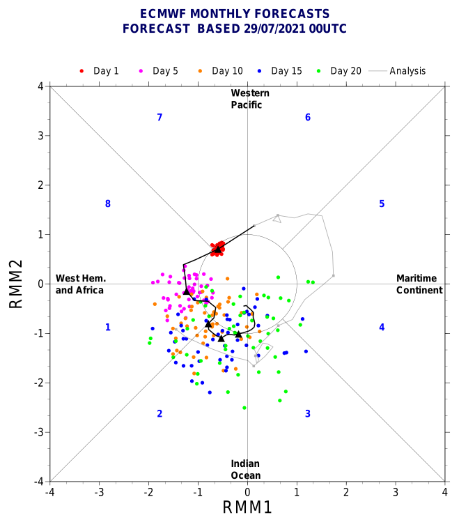
According to the ECMWF, August will have Phases VIII, I, and II of the MJO at a high amplitude. Come September, the MJO will be at a much lower amplitude. Therefore, there is likely going to be a burst of activity in August followed by a train of activity in September. Who knows about October, November, or December?
1 likes   

User avatar
aspen
Category 5
Category 5
Posts: 8818
Joined: Sat Oct 12, 2019 7:10 pm
Location: Connecticut, USA

Re: 2021 Indicators: SST's / SAL / MSLP / Shear / Steering / Instability / Sat Images

#2072 Postby aspen » Mon Aug 02, 2021 7:30 am

AlphaToOmega wrote:According to the ECMWF, August will have Phases VIII, I, and II of the MJO at a high amplitude. Come September, the MJO will be at a much lower amplitude. Therefore, there is likely going to be a burst of activity in August followed by a train of activity in September. Who knows about October, November, or December?

If the CFS is to be believed, the last two weeks or August are gonna be nuts once the MJO finally leaves the EPac behind. However, while sinking motion and Caribbean shear will still be in place as long as the EPac -VP cell exists, the lackluster performance of this trio of EPac systems and the basin’s base state suggests any future systems will probably have trouble and impart less of their own shear into the Atlantic. If a storm tracks north of the Caribbean, it’ll avoid most of that shear.
0 likes   
Irene '11 Sandy '12 Hermine '16 5/15/2018 Derecho Fay '20 Isaias '20 Elsa '21 Henri '21 Ida '21

I am only a meteorology enthusiast who knows a decent amount about tropical cyclones. Look to the professional mets, the NHC, or your local weather office for the best information.

User avatar
NotSparta
Professional-Met
Professional-Met
Posts: 1670
Age: 23
Joined: Fri Aug 18, 2017 8:24 am
Location: Naples, FL
Contact:

Re: 2021 Indicators: SST's / SAL / MSLP / Shear / Steering / Instability / Sat Images

#2073 Postby NotSparta » Mon Aug 02, 2021 7:47 am

Shell Mound wrote:
jconsor wrote:I am skeptical of the EPS for the wave just off the African coast currently. Next wave likely has a better chance to develop.

https://twitter.com/AndyHazelton/status/1422155493372481536

https://twitter.com/AndyHazelton/status/1422156861734785028
https://twitter.com/AndyHazelton/status/1422160640752431109
https://twitter.com/dmorris9661/status/1422162833295527941
The tone of the discussion in the thread sounds very bearish in regard to the Atlantic through the last week of August. In particular some contributors mention cooler SST along 15°N that would hinder any system that manages to extricate itself from the ITCZ. Others also note that the EPS has apparently trended slightly toward the GEFS’s slower eastward progression of the -VP over the EPAC. They only intimate that due to climatology (!) the Atlantic “might” become a little more conducive for TCG beyond August 20, particularly during September, and that the -VP over the EPAC needs to be centred east of 60°W for the Atlantic to enter its most favourable state. To me all this sounds extremely bearish.


Sounds like confirmation bias to me. Have only really seen people bearish on the first couple of weeks, then it's really all systems go as MJO and climo align for a peak season burst it looks like
9 likes   
This post was probably an opinion of mine, and in no way is official. Please refer to http://www.hurricanes.gov for official tropical analysis and advisories.

My website, with lots of tropical wx graphics, including satellite and recon: http://cyclonicwx.com

User avatar
InfernoFlameCat
Category 5
Category 5
Posts: 2102
Age: 22
Joined: Mon Dec 14, 2020 10:52 am
Location: Buford, GA

Re: 2021 Indicators: SST's / SAL / MSLP / Shear / Steering / Instability / Sat Images

#2074 Postby InfernoFlameCat » Mon Aug 02, 2021 8:12 am

That VP cell needs to go in the Epac. Every little thing over there is getting spun up. Share that with the ATL please.
1 likes   
I am by no means a professional. DO NOT look at my forecasts for official information or make decisions based on what I post.

Goal: to become a registered expert over tropical and subtropical cyclones.

User avatar
aspen
Category 5
Category 5
Posts: 8818
Joined: Sat Oct 12, 2019 7:10 pm
Location: Connecticut, USA

Re: 2021 Indicators: SST's / SAL / MSLP / Shear / Steering / Instability / Sat Images

#2075 Postby aspen » Mon Aug 02, 2021 8:19 am

If the EPac was capable of producing actually decent TCs then this phase with the -VP cell and MJO forcing would be interesting…but it’s not, so now we’re all just stuck nitpicking over shear forecasts and MJO propagation and the most minute VP anomalies while the EPac tosses out slop storm after slop storm that aren’t worth giving much attention.
0 likes   
Irene '11 Sandy '12 Hermine '16 5/15/2018 Derecho Fay '20 Isaias '20 Elsa '21 Henri '21 Ida '21

I am only a meteorology enthusiast who knows a decent amount about tropical cyclones. Look to the professional mets, the NHC, or your local weather office for the best information.

User avatar
SFLcane
S2K Supporter
S2K Supporter
Posts: 10163
Age: 47
Joined: Sat Jun 05, 2010 1:44 pm
Location: Lake Worth Florida

Re: 2021 Indicators: SST's / SAL / MSLP / Shear / Steering / Instability / Sat Images

#2076 Postby SFLcane » Mon Aug 02, 2021 8:25 am

aspen wrote:If the EPac was capable of producing actually decent TCs then this phase with the -VP cell and MJO forcing would be interesting…but it’s not, so now we’re all just stuck nitpicking over shear forecasts and MJO propagation and the most minute VP anomalies while the EPac tosses out slop storm after slop storm that aren’t worth giving much attention.


Well, the thing is it's the convection that matters. As long as the EPAC is convectively active (even if they are slop TCs) it's gonna hinder the Atlantic.
3 likes   

User avatar
SFLcane
S2K Supporter
S2K Supporter
Posts: 10163
Age: 47
Joined: Sat Jun 05, 2010 1:44 pm
Location: Lake Worth Florida

Re: 2021 Indicators: SST's / SAL / MSLP / Shear / Steering / Instability / Sat Images

#2077 Postby SFLcane » Mon Aug 02, 2021 8:34 am

More East Pacific competition showing up this year apparently so till that shuts down. :sleeping:
0 likes   

User avatar
Category5Kaiju
Category 5
Category 5
Posts: 4097
Joined: Thu Dec 24, 2020 12:45 pm
Location: Seattle

Re: 2021 Indicators: SST's / SAL / MSLP / Shear / Steering / Instability / Sat Images

#2078 Postby Category5Kaiju » Mon Aug 02, 2021 8:36 am

SFLcane wrote:
aspen wrote:If the EPac was capable of producing actually decent TCs then this phase with the -VP cell and MJO forcing would be interesting…but it’s not, so now we’re all just stuck nitpicking over shear forecasts and MJO propagation and the most minute VP anomalies while the EPac tosses out slop storm after slop storm that aren’t worth giving much attention.


Well, the thing is it's the convection that matters. As long as the EPAC is convectively active (even if they are slop TCs) it's gonna hinder the Atlantic.


I would have to imagine though that while that may still be the case, the Atlantic would be more hindered if those EPAC systems actually became strong or stayed closer to North and Central America and were large in size?
1 likes   
Unless explicitly stated, all info in my posts is based on my own opinions and observations. Tropical storms and hurricanes can be extremely dangerous. Do not think you can beat Mother Nature. Refer to an accredited weather research agency or meteorologist if you need to make serious decisions regarding an approaching storm.

AlphaToOmega
Category 5
Category 5
Posts: 1448
Joined: Sat Jun 26, 2021 10:51 am
Location: Somewhere in Massachusetts

Re: 2021 Indicators: SST's / SAL / MSLP / Shear / Steering / Instability / Sat Images

#2079 Postby AlphaToOmega » Mon Aug 02, 2021 8:36 am

EPac storms are often underperforming their expectations by the NHC at least this year. TD 9E was expected to become a tropical storm, yet it never happened. There have been disturbances in the EPac that were given high chances of development (at or above 70%) this year, yet they did not form. This is evidence that the EPac is hostile for tropical cyclogenesis. The only thing that is making the EPac convectively active is a favorable MJO phase.
2 likes   

User avatar
aspen
Category 5
Category 5
Posts: 8818
Joined: Sat Oct 12, 2019 7:10 pm
Location: Connecticut, USA

Re: 2021 Indicators: SST's / SAL / MSLP / Shear / Steering / Instability / Sat Images

#2080 Postby aspen » Mon Aug 02, 2021 8:39 am

SFLcane wrote:
aspen wrote:If the EPac was capable of producing actually decent TCs then this phase with the -VP cell and MJO forcing would be interesting…but it’s not, so now we’re all just stuck nitpicking over shear forecasts and MJO propagation and the most minute VP anomalies while the EPac tosses out slop storm after slop storm that aren’t worth giving much attention.


Well, the thing is it's the convection that matters. As long as the EPAC is convectively active (even if they are slop TCs) it's gonna hinder the Atlantic.

If late week’s wave develops and sticks to a low latitude early on but then gets north of the Caribbean, would it survive? I don’t think the EPac-induced TUTT gets that far east, so maybe it could be something interesting before running into a wall of shear.

The WPac is also out of commission for doing anything worthwhile because the current setup out there is garbage. Only weak, strung-out TCs for the time being it seems.
0 likes   
Irene '11 Sandy '12 Hermine '16 5/15/2018 Derecho Fay '20 Isaias '20 Elsa '21 Henri '21 Ida '21

I am only a meteorology enthusiast who knows a decent amount about tropical cyclones. Look to the professional mets, the NHC, or your local weather office for the best information.


Return to “Talkin' Tropics”

Who is online

Users browsing this forum: NotSparta and 35 guests