The posts in this forum are NOT official forecasts and should not be used as such. They are just the opinion of the poster and may or may not be backed by sound meteorological data. They are NOT endorsed by any professional institution or STORM2K. For official information, please refer to products from the National Hurricane Center and National Weather Service.
wxman57 wrote:Euro is forecasting an additional 13 named storms in the Atlantic, with 7 hurricanes. Below-normal in the East Pac with an additional 9 named storms with 4 hurricanes there. Sounds about right. Activity should pick up the last half of August with quite a bit of activity in September and October. Building La Nina through the fall/winter may make for a late ending season. Hurricane to threaten the FL Peninsula in mid-October, I guarantee it. Right before my trip to Disney...
I still think the MDR will NOT be a very hospitable place for strong storms again this season. Too much dry, sinking air again (like the last couple of years).
This better not happen during our trip to Universal Studios. Grrrr...
0 likes
The posts in this forum are NOT official forecasts and should not be used as such. They are just the opinion of the poster and may or may not be backed by sound meteorological data. They are NOT endorsed by any professional institution or STORM2K. For official information, please refer to products from the NHC and NWS.
Model Runs Cheat Sheet: GFS (5:30 AM/PM, 11:30 AM/PM) HWRF, GFDL, UKMET, NAVGEM (6:30-8:00 AM/PM, 12:30-2:00 AM/PM) ECMWF (1:45 AM/PM) TCVN is a weighted averaged
wxman57 wrote:Euro is forecasting an additional 13 named storms in the Atlantic, with 7 hurricanes. Below-normal in the East Pac with an additional 9 named storms with 4 hurricanes there. Sounds about right. Activity should pick up the last half of August with quite a bit of activity in September and October. Building La Nina through the fall/winter may make for a late ending season. Hurricane to threaten the FL Peninsula in mid-October, I guarantee it. Right before my trip to Disney...
I still think the MDR will NOT be a very hospitable place for strong storms again this season. Too much dry, sinking air again (like the last couple of years).
Phew, 18 total NS and 8 total hurricanes from the Euro. That’s quite aggressive from a model that has continuously underestimated all of the seasons in this recent active streak.
Even if the MDR remains similarly stable as 2018-2020, I still think we’ll see at least one significant storm come from there. 2018 had Florence, 2019 had Lorenzo (and I guess maybe Dorian since it did form in the western MDR), and 2020 had Teddy. Hopefully if one does form, it stays out to sea and becomes a harmless but interesting ACE generator.
Don't forget 2017's Jose and Ophelia; they stayed off to sea and did little damage
I didn’t mention 2017 because it had a much more favorable MDR than the following three seasons, so it’s an unfair comparison to years that had below-average SST anomalies (2018) or years that had other problems like stable air and very large, difficult-to-consolidate waves (2019 and 2020). Also, Ophelia formed from a non-tropical disturbance in the subtropics, not from an AEW in the tropics like Jose.
I am only a meteorology enthusiast who knows a decent amount about tropical cyclones. Look to the professional mets, the NHC, or your local weather office for the best information.
wxman57 wrote:Euro is forecasting an additional 13 named storms in the Atlantic, with 7 hurricanes. Below-normal in the East Pac with an additional 9 named storms with 4 hurricanes there. Sounds about right. Activity should pick up the last half of August with quite a bit of activity in September and October. Building La Nina through the fall/winter may make for a late ending season. Hurricane to threaten the FL Peninsula in mid-October, I guarantee it. Right before my trip to Disney...
I still think the MDR will NOT be a very hospitable place for strong storms again this season. Too much dry, sinking air again (like the last couple of years).
Can someone link me to the ECMWF page which shows what the euro is forecasting for the rest of the season number wise?
wxman57 wrote:Euro is forecasting an additional 13 named storms in the Atlantic, with 7 hurricanes. Below-normal in the East Pac with an additional 9 named storms with 4 hurricanes there. Sounds about right. Activity should pick up the last half of August with quite a bit of activity in September and October. Building La Nina through the fall/winter may make for a late ending season. Hurricane to threaten the FL Peninsula in mid-October, I guarantee it. Right before my trip to Disney...
I still think the MDR will NOT be a very hospitable place for strong storms again this season. Too much dry, sinking air again (like the last couple of years).
Phew, 18 total NS and 8 total hurricanes from the Euro. That’s quite aggressive from a model that has continuously underestimated all of the seasons in this recent active streak. Even if the MDR remains similarly stable as 2018-2020, I still think we’ll see at least one significant storm come from there. 2018 had Florence, 2019 had Lorenzo (and I guess maybe Dorian since it did form in the western MDR), and 2020 had Teddy. Hopefully if one does form, it stays out to sea and becomes a harmless but interesting ACE generator.
Don't forget 2017's Jose and Ophelia; they stayed off to sea and did little damage
wxman57 is referring to storms that become strong while in the MDR. Since 2017 only Lorenzo (2019) became a major hurricane in the MDR. Anyway, roughly two-thirds (67%) of the approximately thirty Category-4+ hurricanes to strike the CONUS since 1851 originated in the MDR, of which about a third (33%) first attained hurricane status while in the MDR, so an inactive MDR would certainly decrease the risk of a Category-4+ landfall on the CONUS, especially of a strong TUTT as well as sinking air is present, given that a middling TS or marginal hurricane would likely struggle to survive the combination of enhanced VWS and marginal thermodynamics, particularly if it is a small system, as is favoured during -AMO cycles and years with high background pressures. Additionally, of the approximately fifteen storms to have made landfall on the CONUS with MSW ≥ 125 kt, roughly one-third (33%) first attained hurricane status while in the MDR.
Regardless, the upcoming pattern during September looks similar to that which accompanied Hurricane Dean in 2007, keeping most systems south of the CONUS:
The posts in this forum are NOT official forecasts and should not be used as such. They are just the opinion of the poster and may or may not be backed by sound meteorological data. They are NOT endorsed by any professional institution or STORM2K. For official information, please refer to products from the NHC and NWS.
aspen wrote:Phew, 18 total NS and 8 total hurricanes from the Euro. That’s quite aggressive from a model that has continuously underestimated all of the seasons in this recent active streak. Even if the MDR remains similarly stable as 2018-2020, I still think we’ll see at least one significant storm come from there. 2018 had Florence, 2019 had Lorenzo (and I guess maybe Dorian since it did form in the western MDR), and 2020 had Teddy. Hopefully if one does form, it stays out to sea and becomes a harmless but interesting ACE generator.
Don't forget 2017's Jose and Ophelia; they stayed off to sea and did little damage
wxman57 is referring to storms that become strong while in the MDR. Since 2017 only Lorenzo (2019) became a major hurricane in the MDR. Anyway, roughly two-thirds (67%) of the approximately thirty Category-4+ hurricanes to strike the CONUS since 1851 originated in the MDR, of which about a third (33%) first attained hurricane status while in the MDR, so an inactive MDR would certainly decrease the risk of a Category-4+ landfall on the CONUS, especially of a strong TUTT as well as sinking air is present, given that a middling TS or marginal hurricane would likely struggle to survive the combination of enhanced VWS and marginal thermodynamics, particularly if it is a small system, as is favoured during -AMO cycles and years with high background pressures. Additionally, of the approximately fifteen storms to have made landfall on the CONUS with MSW ≥ 125 kt, roughly one-third (33%) first attained hurricane status while in the MDR.
Regardless, the upcoming pattern during September looks similar to that which accompanied Hurricane Dean in 2007, keeping most systems south of the CONUS:
Teddy reached Cat 4 at around 19.8N IIRC and Cat 3 earlier than that. While it's borderline, it still fits the technical definition of the MDR (10-20N latitude wise).
wxman57 wrote:Euro is forecasting an additional 13 named storms in the Atlantic, with 7 hurricanes. Below-normal in the East Pac with an additional 9 named storms with 4 hurricanes there. Sounds about right. Activity should pick up the last half of August with quite a bit of activity in September and October. Building La Nina through the fall/winter may make for a late ending season. Hurricane to threaten the FL Peninsula in mid-October, I guarantee it. Right before my trip to Disney...
I still think the MDR will NOT be a very hospitable place for strong storms again this season. Too much dry, sinking air again (like the last couple of years).
This better not happen during our trip to Universal Studios. Grrrr...
Critical that you get the skip the line upgrades for both Islands of Adventure and Universal. It’s not critical for Typhoon Lagoon. I told I-hater that last month, but we were literally lapping people multiple times on re-rides. Duff’s Beer is pretty good too. Haha
We have made it to MJO Phase 8.
Check out the VP Anomalies for Weeks 1 and particularly Week 2. Might see one or two things form before, but look out middle of the month and at least for a couple weeks thereafter. http://mikeventrice.weebly.com/mjo.html
Last edited by Steve on Tue Aug 03, 2021 10:26 am, edited 1 time in total.
Category5Kaiju wrote:Don't forget 2017's Jose and Ophelia; they stayed off to sea and did little damage
wxman57 is referring to storms that become strong while in the MDR. Since 2017 only Lorenzo (2019) became a major hurricane in the MDR. Anyway, roughly two-thirds (67%) of the approximately thirty Category-4+ hurricanes to strike the CONUS since 1851 originated in the MDR, of which about a third (33%) first attained hurricane status while in the MDR, so an inactive MDR would certainly decrease the risk of a Category-4+ landfall on the CONUS, especially of a strong TUTT as well as sinking air is present, given that a middling TS or marginal hurricane would likely struggle to survive the combination of enhanced VWS and marginal thermodynamics, particularly if it is a small system, as is favoured during -AMO cycles and years with high background pressures. Additionally, of the approximately fifteen storms to have made landfall on the CONUS with MSW ≥ 125 kt, roughly one-third (33%) first attained hurricane status while in the MDR.
Regardless, the upcoming pattern during September looks similar to that which accompanied Hurricane Dean in 2007, keeping most systems south of the CONUS:
Teddy reached Cat 4 at around 19.8N IIRC and Cat 3 earlier than that. While it's borderline, it still fits the technical definition of the MDR (10-20N latitude wise).
You are correct. Its TCR confirms that Teddy became a MH (100 kt) at 18.9°N and a Category 4 (115 kt) at 19.7°N. So Teddy and Lorenzo are the exceptions.
0 likes
CVW / MiamiensisWx / Shell Mound
The posts in this forum are NOT official forecasts and should not be used as such. They are just the opinion of the poster and may or may not be backed by sound meteorological data. They are NOT endorsed by any professional institution or STORM2K. For official information, please refer to products from the NHC and NWS.
Shell Mound wrote:wxman57 is referring to storms that become strong while in the MDR. Since 2017 only Lorenzo (2019) became a major hurricane in the MDR. Anyway, roughly two-thirds (67%) of the approximately thirty Category-4+ hurricanes to strike the CONUS since 1851 originated in the MDR, of which about a third (33%) first attained hurricane status while in the MDR, so an inactive MDR would certainly decrease the risk of a Category-4+ landfall on the CONUS, especially of a strong TUTT as well as sinking air is present, given that a middling TS or marginal hurricane would likely struggle to survive the combination of enhanced VWS and marginal thermodynamics, particularly if it is a small system, as is favoured during -AMO cycles and years with high background pressures. Additionally, of the approximately fifteen storms to have made landfall on the CONUS with MSW ≥ 125 kt, roughly one-third (33%) first attained hurricane status while in the MDR.
Regardless, the upcoming pattern during September looks similar to that which accompanied Hurricane Dean in 2007, keeping most systems south of the CONUS:
Teddy reached Cat 4 at around 19.8N IIRC and Cat 3 earlier than that. While it's borderline, it still fits the technical definition of the MDR (10-20N latitude wise).
You are correct. Its TCR confirms that Teddy became a MH (100 kt) at 18.9°N and a Category 4 (115 kt) at 19.7°N. So Teddy and Lorenzo are the exceptions.
Helene ‘18 should be mentioned as well, as it peaked at 95kt/967mbar at 16.2N but very far east in the MDR. Florence technically was a MDR hurricane, but it didn’t hit that intensity until it was less than a degree south of 20N.
2018 had a surprising number of MDR hurricanes despite its very cool MDR anomalies: Beryl as a rare early July MDR hurricane, Florence as a Cat 1, Helene as a strong Cat 2, and Issac as a weak Cat 1. Both Florence and Helene became MDR hurricanes east of 45W.
I am only a meteorology enthusiast who knows a decent amount about tropical cyclones. Look to the professional mets, the NHC, or your local weather office for the best information.
aspen wrote:I was about to post how the wave quickly developed but got a little too north and weakened. However, if it continues westward after that and doesn’t completely die, it would run into warmer SSTs and perhaps have a chance there.
Every day is trending towards stronger development. Often times, storms do not develop much until they get closer to the Caribbean. The cooler SSTs may help with this. Also, some models earlier this year were often underestimating the strength of the storms.
Exactly; you don't need to have a long-track storm that immediately gets strong in the MDR. We saw this with storms like 2010 Earl and the 1900 Galveston hurricane that remained a TS throughout the MDR but became strong when in the WAtl
Either the strong African monsoon will cause systems to ricochet northward into cooler and more stable conditions, as we observed last season, or the combination of a suppressed ITCZ and strong ridging will result in 2007-type tracks into Central America. Furthermore, the Atlantic Niño means that the warmest SST will be located farther south in the MDR, closer to the equator, than were observed in 2020. I think we will see many sprawling waves that either die early on and/or get ripped apart by strong trades and interaction with South America near the Windwards. I think major hurricanes will tend to concentrate close to Central America, including Yucatán, and/or OTS in the subtropical Atlantic. At this point 2007 should be a leading analog in terms of expected tracks.
This is already becoming 2021’s theme: “too much of a good thing” for significant TCG in the MDR, owing to the strong African monsoon.
0 likes
CVW / MiamiensisWx / Shell Mound
The posts in this forum are NOT official forecasts and should not be used as such. They are just the opinion of the poster and may or may not be backed by sound meteorological data. They are NOT endorsed by any professional institution or STORM2K. For official information, please refer to products from the NHC and NWS.
aspen wrote:Phew, 18 total NS and 8 total hurricanes from the Euro. That’s quite aggressive from a model that has continuously underestimated all of the seasons in this recent active streak. Even if the MDR remains similarly stable as 2018-2020, I still think we’ll see at least one significant storm come from there. 2018 had Florence, 2019 had Lorenzo (and I guess maybe Dorian since it did form in the western MDR), and 2020 had Teddy. Hopefully if one does form, it stays out to sea and becomes a harmless but interesting ACE generator.
Don't forget 2017's Jose and Ophelia; they stayed off to sea and did little damage
wxman57 is referring to storms that become strong while in the MDR. Since 2017 only Lorenzo (2019) became a major hurricane in the MDR. Anyway, roughly two-thirds (67%) of the approximately thirty Category-4+ hurricanes to strike the CONUS since 1851 originated in the MDR, of which about a third (33%) first attained hurricane status while in the MDR, so an inactive MDR would certainly decrease the risk of a Category-4+ landfall on the CONUS, especially of a strong TUTT as well as sinking air is present, given that a middling TS or marginal hurricane would likely struggle to survive the combination of enhanced VWS and marginal thermodynamics, particularly if it is a small system, as is favoured during -AMO cycles and years with high background pressures. Additionally, of the approximately fifteen storms to have made landfall on the CONUS with MSW ≥ 125 kt, roughly one-third (33%) first attained hurricane status while in the MDR.
Regardless, the upcoming pattern during September looks similar to that which accompanied Hurricane Dean in 2007, keeping most systems south of the CONUS:
Not buying the "the Gulf is going to be hostile" tweet. It is way too far out to know if conditions will be favorable IF the wave manages to move that far west. Also, I recall experts talking about unfavorable conditions in an area on a long-range forecast before. Many times, these experts are wrong because the models have not completely adjusted to the rapidly changing conditions that are ongoing near peak season.
I don’t know if this is an indicator or not. My nephew is getting married on Kitty Hawk Pier on Sept 14. Family will be here two weeks starting Sept 11. Now an optimist would say this should keep away hurricanes for at least two weeks. A realist would say a wedding on a pier on the Outer Banks at the peak of hurricane season. Really!
Category5Kaiju wrote:Don't forget 2017's Jose and Ophelia; they stayed off to sea and did little damage
wxman57 is referring to storms that become strong while in the MDR. Since 2017 only Lorenzo (2019) became a major hurricane in the MDR. Anyway, roughly two-thirds (67%) of the approximately thirty Category-4+ hurricanes to strike the CONUS since 1851 originated in the MDR, of which about a third (33%) first attained hurricane status while in the MDR, so an inactive MDR would certainly decrease the risk of a Category-4+ landfall on the CONUS, especially of a strong TUTT as well as sinking air is present, given that a middling TS or marginal hurricane would likely struggle to survive the combination of enhanced VWS and marginal thermodynamics, particularly if it is a small system, as is favoured during -AMO cycles and years with high background pressures. Additionally, of the approximately fifteen storms to have made landfall on the CONUS with MSW ≥ 125 kt, roughly one-third (33%) first attained hurricane status while in the MDR.
Regardless, the upcoming pattern during September looks similar to that which accompanied Hurricane Dean in 2007, keeping most systems south of the CONUS:
Not buying the "the Gulf is going to be hostile" tweet.
The tweet actually does not indicate that the Gulf is going to be “hostile.” In fact, it actually indicates the opposite. However, it also mentions a PV streamer (TUTT) between relatively conducive UL conditions in the Gulf and easternmost MDR, respectively. The problem this year is that SST and THC in the MDR are far cooler than in 2020 and that the monsoonal trough will likely cause many waves to eject north of 15°N, thereby causing them to encounter more hostile thermodynamics and dissipate early on. Also, the strong monsoon and suppressed ITCZ, combined with strong ridging, imply that waves, as constituted, will tend to be sprawling in nature and struggle to develop until reaching either the subtropics or the western Caribbean. At this point I am definitely optimistic for the CONUS’s prospects during the peak of the season, but perhaps Central America will be less fortunate, sadly.
0 likes
CVW / MiamiensisWx / Shell Mound
The posts in this forum are NOT official forecasts and should not be used as such. They are just the opinion of the poster and may or may not be backed by sound meteorological data. They are NOT endorsed by any professional institution or STORM2K. For official information, please refer to products from the NHC and NWS.
captainbarbossa19 wrote:Every day is trending towards stronger development. Often times, storms do not develop much until they get closer to the Caribbean. The cooler SSTs may help with this. Also, some models earlier this year were often underestimating the strength of the storms.
Exactly; you don't need to have a long-track storm that immediately gets strong in the MDR. We saw this with storms like 2010 Earl and the 1900 Galveston hurricane that remained a TS throughout the MDR but became strong when in the WAtl
Either the strong African monsoon will cause systems to ricochet northward into cooler and more stable conditions, as we observed last season, or the combination of a suppressed ITCZ and strong ridging will result in 2007-type tracks into Central America. Furthermore, the Atlantic Niño means that the warmest SST will be located farther south in the MDR, closer to the equator, than were observed in 2020. I think we will see many sprawling waves that either die early on and/or get ripped apart by strong trades and interaction with South America near the Windwards. I think major hurricanes will tend to concentrate close to Central America, including Yucatán, and/or OTS in the subtropical Atlantic. At this point 2007 should be a leading analog in terms of expected tracks.
This is already becoming 2021’s theme: “too much of a good thing” for significant TCG in the MDR, owing to the strong African monsoon.
Things can change in a month and basing this off of one of two systems isn’t a good forecast. Also 2007 was horrible outside of Dean and Felix with nothing above C1, which definitely isn’t gonna be the case for 2021. I still strongly believe that come September the southern ITCZ and Atlantic Niño combined with the other coming favorable conditions will lead to stronger MDR systems then last year.
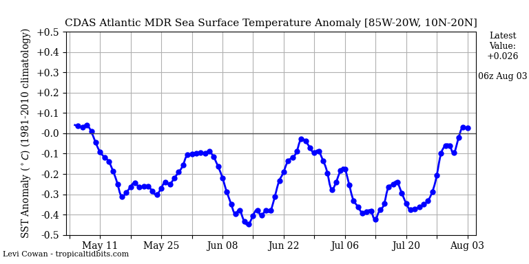
If the CDAS says above average, that's when you know it truly is above average.
8 likes
Unless explicitly stated, all info in my posts is based on my own opinions and observations. Tropical storms and hurricanes can be extremely dangerous. Refer to an accredited weather research agency or meteorologist if you need to make serious decisions regarding an approaching storm.
If the upcoming wave consolidates quicker and becomes a TS before being impacted by the monsoon trough, will that change how much it’ll be dragged north?
If it’s able to stick around 14-15N, it’ll be riding that thin line between favorable and unfavorable SSTs, before ocean temps to its north warm up by about 45-50W.
I am only a meteorology enthusiast who knows a decent amount about tropical cyclones. Look to the professional mets, the NHC, or your local weather office for the best information.
OuterBanker wrote:I don’t know if this is an indicator or not. My nephew is getting married on Kitty Hawk Pier on Sept 14. Family will be here two weeks starting Sept 11. Now an optimist would say this should keep away hurricanes for at least two weeks. A realist would say a wedding on a pier on the Outer Banks at the peak of hurricane season. Really!
I think I'm going with the realist! But you never know.
0 likes
"But it never rained rain. It never snowed snow. And it never blew just wind. It rained things like soup and juice. It snowed mashed potatoes and green peas. And sometimes the wind blew in storms of hamburgers." -- Judi Barrett, Cloudy with a Chance of Meatballs
Updated NMME comes out the 13th should be interesting.
NMME updates before the 8th of each month. Data output in .netcdf and .grib is released a day before the graphics are made (usually on the 6th or 7th) and can be found here - ftp://ftp.cpc.ncep.noaa.gov/NMME/realtime_anom/ENSMEAN/. This includes the following models:


